Bridge Statistics for Northampton, Pennsylvania (PA)
Condition, Traffic, Stress, Structural Evaluation, Project Costs
- National Bridge Inventory (NBI) Statistics
- 14Number of bridges
- 118ft / 35.5mTotal length
- $2,856,000Total costs
- 48,529Total average daily traffic
- 2,695Total average daily truck traffic
- 62,567Total future (year 2022) average daily traffic
- National Bridge Inventory (NBI) Registered Bridges for Northampton
- No street view available for this location
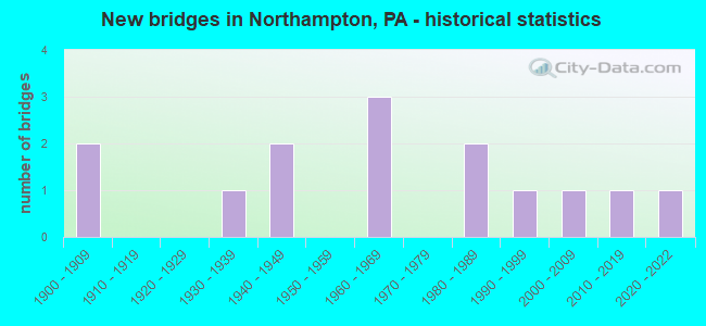
- New bridges - historical statistics
- 21900-1909
- 11930-1939
- 21940-1949
- 31960-1969
- 21980-1989
- 11990-1999
- 12000-2009
- 12010-2019
- 12020-2022
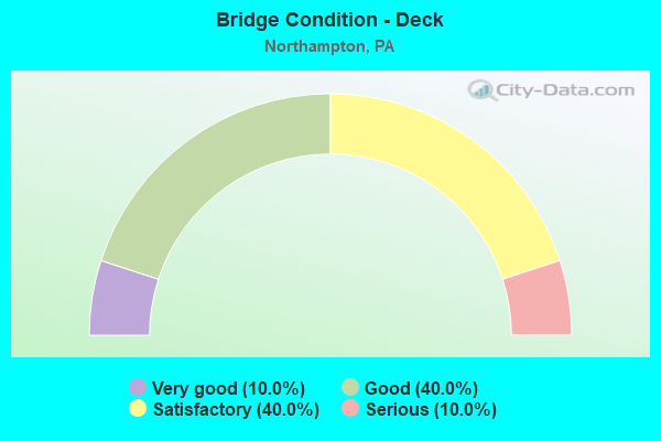
- Bridge Condition - Deck
- 10.0%Very good
- 40.0%Good
- 40.0%Satisfactory
- 10.0%Serious
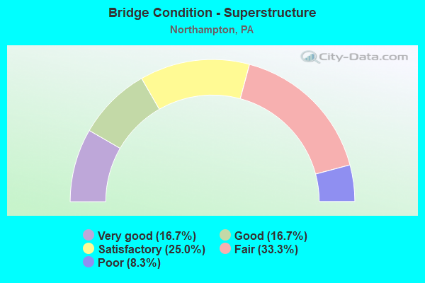
- Bridge Condition - Superstructure
- 16.7%Very good
- 16.7%Good
- 25.0%Satisfactory
- 33.3%Fair
- 8.3%Poor
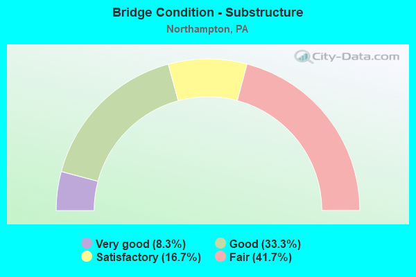
- Bridge Condition - Substructure
- 8.3%Very good
- 33.3%Good
- 16.7%Satisfactory
- 41.7%Fair
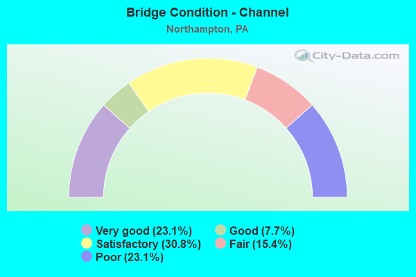
- Bridge Condition - Channel
- 23.1%Very good
- 7.7%Good
- 30.8%Satisfactory
- 15.4%Fair
- 23.1%Poor
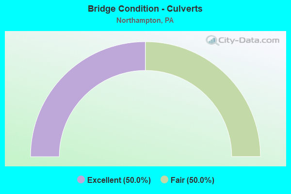
- Bridge Condition - Culverts
- 50.0%Excellent
- 50.0%Fair
Find on map >> Show street view
Structure Number: 2859, Location: NORTHAMPTON BORO LINE (Lat: 40.694219, Lng: -75.491328), Route carried "on" structure: State highway 329, Year Built: 1909, Year Reconstructed: 1982, Status: Open, Structure Length: 3.84m (12.60ft), Average Daily Traffic: 11,964 (year 2021), Truck Traffic: 5%, Average Future Daily Traffic: 15,086 (year 2032), Design Load: HS 20, Features Intersected: HOKENDAUQUA CREEK
Minimum Vertical Clearance: 30+ m (98+ ft), Kilometerpoint: 0.998, Lanes on structure: 2, Base Highway Network: Yes, Owner: State Highway Agency, Approaching Roadway Width: 11.0m (36.1ft), Material/Design: Concrete, Design/Construction: Arch - Deck, Number Of Spans In Main Unit: 2, Length of Maximum Span: 19.2m (63.0ft), Curb-To-Curb Width: 9.1m (29.9ft), Out-to-Out Width: 10.0m (32.8ft)
Condition: Superstructure: Fair, Substructure: Fair, Channel: Poor, Operating Rating: 49.0 metric tons, Method Used To Determine Operating Rating: Field evaluation and documented engineering judgment, Inventory Rating: 32.7 metric tons, Method Used To Determine Inventory Rating: Field evaluation and documented engineering judgment, Structural Evaluation: Somewhat better than minimum adequacy, Deck Geometry: High priority of corrective action, Waterway Adequacy: Better than present minimum criteria, Approach Roadway Alignment: Equal to present desirable criteria, Length Of Structure Improvement: 4.60m (15.09ft), Designated Inspection Frequency: Every 24 months, Inspection Date: March 2020, Bridge Improvement Cost: $125,000, Roadway Improvement Cost: $369,000, Total Project Cost: $1,691,000, Wearing Surface/Protective System: Wearing Surface: Bituminous
Find on map >> Show street view
Structure Number: 28593, Location: NOR-BATH BOULEVARD (Lat: 40.698147, Lng: -75.450189), Route carried "on" structure: State highway 329, Year Built: 1945, Status: Open, Structure Length: 1.31m (4.30ft), Average Daily Traffic: 10,363 (year 2022), Truck Traffic: 9%, Average Future Daily Traffic: 11,628 (year 2032), Design Load: HS 20, Features Intersected: CATASAUQUA CREEK
Minimum Vertical Clearance: 30+ m (98+ ft), Kilometerpoint: 3.906, Lanes on structure: 2, Base Highway Network: Yes, Owner: State Highway Agency, Approaching Roadway Width: 12.8m (42.0ft), Material/Design: Concrete, Design/Construction: Tee Beam, Number Of Spans In Main Unit: 1, Length of Maximum Span: 12.5m (41.0ft), Curb-To-Curb Width: 12.3m (40.4ft), Out-to-Out Width: 13.3m (43.6ft)
Condition: Deck: Satisfactory, Superstructure: Satisfactory, Substructure: Fair, Channel: Poor, Operating Rating: 58.1 metric tons, Method Used To Determine Operating Rating: Load Factor (LF), Inventory Rating: 34.5 metric tons, Method Used To Determine Inventory Rating: Load Factor (LF), Structural Evaluation: Somewhat better than minimum adequacy, Deck Geometry: Somewhat better than minimum adequacy, Waterway Adequacy: Equal to present desirable criteria, Approach Roadway Alignment: Equal to present desirable criteria, Length Of Structure Improvement: 2.00m (6.56ft), Designated Inspection Frequency: Every 24 months, Inspection Date: March 2020, Bridge Improvement Cost: $14,000, Roadway Improvement Cost: $40,000, Total Project Cost: $184,000, Deck Structure Type: Concrete Cast-file-Place, Wearing Surface/Protective System: Wearing Surface: Bituminous
Find on map >> Show street view
Structure Number: 28765, Location: INDIAN TRAIL ROAD (Lat: 40.720897, Lng: -75.504258), Route carried "on" structure: State highway , Year Built: 1939, Status: Open, Structure Length: 2.87m (9.42ft), Average Daily Traffic: 2,523 (year 2022), Truck Traffic: 4%, Average Future Daily Traffic: 3,865 (year 2032), Design Load: HS 20, Features Intersected: HOKENDAUQUA CREEK, Facility Carried by Structure: SR 3016(LR48068)
Minimum Vertical Clearance: 30+ m (98+ ft), Kilometerpoint: 0.985, Lanes on structure: 2, Owner: State Highway Agency, Approaching Roadway Width: 7.9m (25.9ft), Material/Design: Steel, Design/Construction: Stringer/Multi-beam, Number Of Spans In Main Unit: 2, Length of Maximum Span: 13.7m (44.9ft), Curb-To-Curb Width: 8.0m (26.2ft), Out-to-Out Width: 8.7m (28.5ft)
Condition: Deck: Serious, Superstructure: Poor, Substructure: Fair, Channel: Fair, Operating Rating: 44.5 metric tons, Method Used To Determine Operating Rating: Load Factor (LF), Inventory Rating: 26.3 metric tons, Method Used To Determine Inventory Rating: Load Factor (LF), Structural Evaluation: Meets minimum limits, Deck Geometry: High priority of corrective action, Waterway Adequacy: Better than present minimum criteria, Approach Roadway Alignment: Better than present minimum criteria, Length Of Structure Improvement: 3.60m (11.81ft), Designated Inspection Frequency: Every 24 months, Other Special Inspection Frequency: Every 6 months, Inspection Date: December 2020, Other Special Inspection Date: June 2021, Bridge Improvement Cost: $13,000, Roadway Improvement Cost: $37,000, Total Project Cost: $172,000, Deck Structure Type: Concrete Cast-file-Place, Wearing Surface/Protective System: Wearing Surface: Bituminous
Find on map >> Show street view
Structure Number: 28773, Location: 1.7 MI.N.OF PA 329 (Lat: 40.713917, Lng: -75.495619), Route carried "on" structure: State highway , Year Built: 1949, Status: Open, Structure Length: 3.26m (10.70ft), Average Daily Traffic: 3,776 (year 2022), Truck Traffic: 4%, Average Future Daily Traffic: 5,466 (year 2032), Design Load: HS 20, Features Intersected: HOKENDAUQUA CREEK, Facility Carried by Structure: SR 4003 (LR 48061)
Minimum Vertical Clearance: 30+ m (98+ ft), Kilometerpoint: 2.760, Lanes on structure: 2, Owner: State Highway Agency, Approaching Roadway Width: 8.5m (27.9ft), Skew: 1 degrees, Material/Design: Steel, Design/Construction: Stringer/Multi-beam, Number Of Spans In Main Unit: 2, Length of Maximum Span: 15.5m (50.9ft), Curb-To-Curb Width: 8.5m (27.9ft), Out-to-Out Width: 9.0m (29.5ft)
Condition: Deck: Satisfactory, Superstructure: Fair, Substructure: Fair, Channel: Fair, Operating Rating: 53.5 metric tons, Method Used To Determine Operating Rating: Load Factor (LF), Inventory Rating: 31.8 metric tons, Method Used To Determine Inventory Rating: Load Factor (LF), Structural Evaluation: Somewhat better than minimum adequacy, Deck Geometry: Meets minimum limits, Waterway Adequacy: Better than present minimum criteria, Approach Roadway Alignment: Better than present minimum criteria, Length Of Structure Improvement: 4.10m (13.45ft), Designated Inspection Frequency: Every 24 months, Inspection Date: January 2021, Bridge Improvement Cost: $50,000, Roadway Improvement Cost: $146,000, Total Project Cost: $669,000, Deck Structure Type: Open Grating
Find on map >> Show street view
Structure Number: 28774, Location: KREIDERSVILLE ROAD (Lat: 40.726325, Lng: -75.493453), Route carried "on" structure: State highway , Year Built: 1962, Status: Open, Structure Length: 1.83m (6.00ft), Average Daily Traffic: 2,974 (year 2022), Truck Traffic: 6%, Average Future Daily Traffic: 4,528 (year 2032), Design Load: HS 20, Features Intersected: HOKENDAUQUA CREEK, Facility Carried by Structure: SR 4003 (LR 48061)
Minimum Vertical Clearance: 30+ m (98+ ft), Kilometerpoint: 3.888, Lanes on structure: 2, Owner: State Highway Agency, Approaching Roadway Width: 10.1m (33.1ft), Skew: 1 degrees, Material/Design: Prestressed concrete, Design/Construction: Box Beam or Girders - Single/Spread, Number Of Spans In Main Unit: 1, Length of Maximum Span: 18.0m (59.1ft), Curb-To-Curb Width: 8.5m (27.9ft), Out-to-Out Width: 10.2m (33.5ft)
Condition: Deck: Satisfactory, Superstructure: Good, Substructure: Satisfactory, Channel: Satisfactory, Operating Rating: 71.7 metric tons, Method Used To Determine Operating Rating: Load Factor (LF), Inventory Rating: 42.6 metric tons, Method Used To Determine Inventory Rating: Load Factor (LF), Structural Evaluation: Equal to present minimum criteria, Deck Geometry: Meets minimum limits, Waterway Adequacy: Equal to present desirable criteria, Approach Roadway Alignment: Equal to present desirable criteria, Length Of Structure Improvement: 2.50m (8.20ft), Designated Inspection Frequency: Every 48 months, Inspection Date: December 2018, Bridge Improvement Cost: $10,000, Roadway Improvement Cost: $31,000, Total Project Cost: $140,000, Deck Structure Type: Concrete Cast-file-Place, Wearing Surface/Protective System: Wearing Surface: Bituminous
Find on map >> Show street view
Structure Number: 28804, Location: NW KREIDERSVILLE (Lat: 40.723425, Lng: -75.500692), Route carried "on" structure: City street , Year Built: 1909, Status: Open, Structure Length: 1.49m (4.89ft), Average Daily Traffic: 100 (year 2010), Truck Traffic: 1%, Average Future Daily Traffic: 150 (year 2030), Design Load: HS 15, Features Intersected: HOKENDAUQUA CREEK, Facility Carried by Structure: TOMAHAWK TRAIL
Minimum Vertical Clearance: 30+ m (98+ ft), Kilometerpoint: 0.000, Lanes on structure: 2, Owner: County Highway Agency, Approaching Roadway Width: 5.2m (17.1ft), Material/Design: Concrete, Design/Construction: Arch - Deck, Number Of Spans In Main Unit: 1, Length of Maximum Span: 14.9m (48.9ft), Curb-To-Curb Width: 4.5m (14.8ft), Out-to-Out Width: 5.4m (17.7ft)
Condition: Superstructure: Satisfactory, Substructure: Satisfactory, Channel: Satisfactory, Operating Rating: 40.8 metric tons, Method Used To Determine Operating Rating: Field evaluation and documented engineering judgment, Inventory Rating: 32.7 metric tons, Method Used To Determine Inventory Rating: Field evaluation and documented engineering judgment, Structural Evaluation: Equal to present minimum criteria, Deck Geometry: High priority of replacement, Waterway Adequacy: Better than present minimum criteria, Approach Roadway Alignment: Equal to present desirable criteria, Length Of Structure Improvement: 2.30m (7.55ft), Designated Inspection Frequency: Every 24 months, Inspection Date: May 2020
Find on map >> Show street view
Structure Number: 28817, Location: EAST OF SR 3021 (Lat: 40.712892, Lng: -75.448942), Route carried "on" structure: City street , Year Built: 1991, Status: Open, Structure Length: 1.01m (3.31ft), Average Daily Traffic: 300 (year 2015), Truck Traffic: 1%, Average Future Daily Traffic: 250 (year 2035), Design Load: HS 20, Features Intersected: CATASAUQUA CREEK, Facility Carried by Structure: HILLSIDE ROAD
Minimum Vertical Clearance: 30+ m (98+ ft), Kilometerpoint: 0.000, Lanes on structure: 2, Owner: County Highway Agency, Approaching Roadway Width: 6.1m (20.0ft), Material/Design: Prestressed concrete, Design/Construction: Box Beam or Girders - Single/Spread, Number Of Spans In Main Unit: 1, Length of Maximum Span: 9.4m (30.8ft), Curb or Sidewalk Widths: Left: 0.2m (0.7ft), Right: 0.2m (0.7ft), Curb-To-Curb Width: 7.3m (24.0ft), Out-to-Out Width: 8.4m (27.6ft)
Condition: Deck: Good, Superstructure: Good, Substructure: Good, Channel: Very good, Operating Rating: 54.4 metric tons, Method Used To Determine Operating Rating: Load Factor (LF), Inventory Rating: 32.7 metric tons, Method Used To Determine Inventory Rating: Load Factor (LF), Structural Evaluation: Better than present minimum criteria, Deck Geometry: Somewhat better than minimum adequacy, Waterway Adequacy: Better than present minimum criteria, Approach Roadway Alignment: Equal to present minimum criteria, Length Of Structure Improvement: 1.60m (5.25ft), Designated Inspection Frequency: Every 24 months, Inspection Date: March 2020, Deck Structure Type: Open Grating, Wearing Surface/Protective System: Wearing Surface: Monolithic Concrete, Deck Protection: Epoxy Coated Reinforcing
Find on map >> Show street view
Structure Number: 28819, Location: .5 M. NORTH OF PA 329 (Lat: 40.704706, Lng: -75.448569), Route carried "on" structure: City street , Year Built: 1966, Status: Open, Structure Length: 1.95m (6.40ft), Average Daily Traffic: 200 (year 2010), Truck Traffic: 1%, Average Future Daily Traffic: 250 (year 2030), Design Load: HS 20, Features Intersected: CATASAUQUA CREEK, Facility Carried by Structure: TANGLEWOOD ROAD
Minimum Vertical Clearance: 30+ m (98+ ft), Kilometerpoint: 0.000, Lanes on structure: 2, Owner: County Highway Agency, Approaching Roadway Width: 7.3m (24.0ft), Skew: 3 degrees, Material/Design: Steel, Design/Construction: Stringer/Multi-beam, Number Of Spans In Main Unit: 1, Length of Maximum Span: 18.0m (59.1ft), Curb or Sidewalk Widths: Left: 0.4m (1.3ft), Right: 0.4m (1.3ft), Curb-To-Curb Width: 8.5m (27.9ft), Out-to-Out Width: 10.2m (33.5ft)
Condition: Deck: Good, Superstructure: Satisfactory, Substructure: Good, Channel: Good, Operating Rating: 55.3 metric tons, Method Used To Determine Operating Rating: Load Factor (LF), Inventory Rating: 32.7 metric tons, Method Used To Determine Inventory Rating: Load Factor (LF), Structural Evaluation: Equal to present minimum criteria, Deck Geometry: Equal to present minimum criteria, Waterway Adequacy: Superior to present desirable criteria, Approach Roadway Alignment: Equal to present desirable criteria, Length Of Structure Improvement: 2.60m (8.53ft), Designated Inspection Frequency: Every 24 months, Inspection Date: March 2020, Deck Structure Type: Concrete Cast-file-Place, Wearing Surface/Protective System: Wearing Surface: Integral Concrete
Find on map >> Show street view
Structure Number: 28931, Location: 1.5 M. SOUTH OF PA 329 (Lat: 40.679292, Lng: -75.489133), Route carried "on" structure: City street , Year Built: 1965, Status: Open, Structure Length: 2.10m (6.89ft), Average Daily Traffic: 1,000 (year 2010), Truck Traffic: 10%, Average Future Daily Traffic: 1,200 (year 2030), Design Load: H 20, Features Intersected: HOKENDAUQUA CREEK, Facility Carried by Structure: MAIN STREET
Minimum Vertical Clearance: 30+ m (98+ ft), Kilometerpoint: 0.000, Lanes on structure: 2, Owner: County Highway Agency, Approaching Roadway Width: 16.5m (54.1ft), Skew: 2 degrees, Material/Design: Steel, Design/Construction: Stringer/Multi-beam, Number Of Spans In Main Unit: 1, Length of Maximum Span: 20.4m (66.9ft), Curb or Sidewalk Widths: Left: 2.2m (7.2ft), Right: 2.2m (7.2ft), Curb-To-Curb Width: 10.5m (34.4ft), Out-to-Out Width: 15.6m (51.2ft)
Condition: Deck: Satisfactory, Superstructure: Fair, Substructure: Fair, Channel: Satisfactory, Inventory Rating: 75.3 metric tons, Method Used To Determine Inventory Rating: Load Factor (LF), Structural Evaluation: Somewhat better than minimum adequacy, Deck Geometry: Equal to present minimum criteria, Waterway Adequacy: Equal to present desirable criteria, Approach Roadway Alignment: Better than present minimum criteria, Length Of Structure Improvement: 2.80m (9.19ft), Designated Inspection Frequency: Every 24 months, Inspection Date: April 2020, Deck Structure Type: Concrete Cast-file-Place, Wearing Surface/Protective System: Wearing Surface: Latex Concrete
Find on map >> Show street view
Structure Number: 28932, Location: OUTLET TO LEHIGH RIVER (Lat: 40.677122, Lng: -75.489775), Route carried "on" structure: City street , Year Built: 1983, Status: Open, Structure Length: 2.23m (7.32ft), Average Daily Traffic: 350 (year 2010), Truck Traffic: 1%, Average Future Daily Traffic: 761 (year 2030), Design Load: HS 20+Mod, Features Intersected: HOKENDAUQUA CREEK, Facility Carried by Structure: CANAL STREET
Minimum Vertical Clearance: 30+ m (98+ ft), Kilometerpoint: 0.000, Lanes on structure: 2, Owner: County Highway Agency, Approaching Roadway Width: 7.3m (24.0ft), Material/Design: Prestressed concrete, Design/Construction: Box Beam or Girders - Multiple, Number Of Spans In Main Unit: 1, Length of Maximum Span: 21.6m (70.9ft), Curb or Sidewalk Widths: Left: 0.2m (0.7ft), Right: 0.2m (0.7ft), Curb-To-Curb Width: 7.6m (24.9ft), Out-to-Out Width: 8.6m (28.2ft)
Condition: Deck: Good, Superstructure: Fair, Substructure: Good, Channel: Satisfactory, Operating Rating: 47.2 metric tons, Method Used To Determine Operating Rating: Load Factor (LF), Inventory Rating: 20.0 metric tons, Method Used To Determine Inventory Rating: Load Factor (LF), Structural Evaluation: Somewhat better than minimum adequacy, Deck Geometry: Somewhat better than minimum adequacy, Waterway Adequacy: Equal to present minimum criteria, Approach Roadway Alignment: Meets minimum limits, Length Of Structure Improvement: 2.80m (9.19ft), Designated Inspection Frequency: Every 24 months, Inspection Date: May 2021, Deck Structure Type: Concrete Precast Panels, Wearing Surface/Protective System: Wearing Surface: Bituminous
Find on map >> Show street view
Structure Number: 41352, Location: NOR-BATH BOULEVARD (Lat: 40.695294, Lng: -75.483528), Route carried "on" structure: State highway 329, Year Built: 2001, Status: Open, Structure Length: 3.90m (12.80ft), Average Daily Traffic: 11,964 (year 2021), Truck Traffic: 5%, Average Future Daily Traffic: 15,086 (year 2036), Design Load: HS 25 or greater, Features Intersected: QUARRY
Minimum Vertical Clearance: 30+ m (98+ ft), Kilometerpoint: 1.745, Lanes on structure: 2, Base Highway Network: Yes, Owner: State Highway Agency, Approaching Roadway Width: 11.9m (39.0ft), Material/Design: Steel, Design/Construction: Stringer/Multi-beam, Number Of Spans In Main Unit: 1, Length of Maximum Span: 37.5m (123.0ft), Curb-To-Curb Width: 12.0m (39.4ft), Out-to-Out Width: 12.9m (42.3ft)
Condition: Deck: Good, Superstructure: Very good, Substructure: Good, Operating Rating: 88.9 metric tons, Method Used To Determine Operating Rating: Load Factor (LF), Inventory Rating: 53.5 metric tons, Method Used To Determine Inventory Rating: Load Factor (LF), Structural Evaluation: Better than present minimum criteria, Deck Geometry: Somewhat better than minimum adequacy, Approach Roadway Alignment: Equal to present desirable criteria, Length Of Structure Improvement: 4.70m (15.42ft), Designated Inspection Frequency: Every 48 months, Inspection Date: November 2019, Deck Structure Type: Concrete Cast-file-Place, Wearing Surface/Protective System: Wearing Surface: Monolithic Concrete, Deck Protection: Epoxy Coated Reinforcing
Find on map >> Show street view
Structure Number: 47415, Location: EAST OF KREIDERSVILLE (Lat: 40.723358, Lng: -75.480458), Route carried "on" structure: City street , Year Built: 1980, Status: Open, Structure Length: 0.64m (2.10ft), Average Daily Traffic: 250 (year 2012), Truck Traffic: 1%, Average Future Daily Traffic: 275 (year 2022), Design Load: HS 20, Features Intersected: TRIB. HOKENDAUQUA CREEK, Facility Carried by Structure: SNOW HILL ROAD
Minimum Vertical Clearance: 30+ m (98+ ft), Kilometerpoint: 0.000, Lanes on structure: 2, Owner: Town or Township Highway Agency, Approaching Roadway Width: 7.3m (24.0ft), Skew: 1 degrees, Material/Design: Concrete, Design/Construction: Culvert, Number Of Spans In Main Unit: 1, Length of Maximum Span: 2.7m (8.9ft), Curb-To-Curb Width: 8.5m (27.9ft), Out-to-Out Width: 8.5m (27.9ft)
Condition: Channel: Poor, Culverts: Fair, Operating Rating: 40.8 metric tons, Method Used To Determine Operating Rating: Field evaluation and documented engineering judgment, Inventory Rating: 24.5 metric tons, Method Used To Determine Inventory Rating: Field evaluation and documented engineering judgment, Structural Evaluation: Somewhat better than minimum adequacy, Deck Geometry: Equal to present minimum criteria, Waterway Adequacy: Better than present minimum criteria, Approach Roadway Alignment: Equal to present desirable criteria, Designated Inspection Frequency: Every 24 months, Inspection Date: August 2020
Find on map >> Show street view
Structure Number: 52457, Location: COLD SPRINGS BRIDGE (Lat: 40.700942, Lng: -75.516819), Route carried "on" structure: State highway , Year Built: 2015, Status: Open, Structure Length: 7.92m (25.98ft), Average Daily Traffic: 2,665 (year 2022), Truck Traffic: 1%, Average Future Daily Traffic: 3,897 (year 2037), Design Load: HL 93, Features Intersected: SPRING CREEK, Facility Carried by Structure: SR 1027 (LR175)
Minimum Vertical Clearance: 30+ m (98+ ft), Kilometerpoint: 0.491, Lanes on structure: 2, Owner: State Highway Agency, Approaching Roadway Width: 10.1m (33.1ft), Material/Design: Prestressed concrete, Design/Construction: Stringer/Multi-beam, Number Of Spans In Main Unit: 3, Length of Maximum Span: 28.3m (92.8ft), Curb or Sidewalk Widths: Left: 0.5m (1.6ft), Right: 0.5m (1.6ft), Curb-To-Curb Width: 9.8m (32.2ft), Out-to-Out Width: 10.9m (35.8ft)
Condition: Deck: Very good, Superstructure: Very good, Substructure: Very good, Channel: Very good, Operating Rating: 43.7 metric tons, Method Used To Determine Operating Rating: Assigned ratings based on Load and Resistance Factor Design (LRFD) reported by rating factor (RF) using HL93 loadings, Inventory Rating: 33.7 metric tons, Method Used To Determine Inventory Rating: Assigned ratings based on Load and Resistance Factor Design (LRFD) reported by rating factor (RF) using HL93 loadings, Structural Evaluation: Equal to present desirable criteria, Deck Geometry: Meets minimum limits, Waterway Adequacy: Superior to present desirable criteria, Approach Roadway Alignment: Equal to present desirable criteria, Designated Inspection Frequency: Every 48 months, Inspection Date: July 2019, Deck Structure Type: Concrete Cast-file-Place, Wearing Surface/Protective System: Wearing Surface: Monolithic Concrete, Deck Protection: Epoxy Coated Reinforcing
Find on map >> Show street view
Structure Number: 67503, Location: East of SR 3021 (Lat: 40.716806, Lng: -75.444833), Route carried "on" structure: City street , Year Built: 2020, Status: Open, Structure Length: 1.16m (3.81ft), Average Daily Traffic: 100 (year 2010), Truck Traffic: 1%, Average Future Daily Traffic: 125 (year 2030), Design Load: HL 93, Features Intersected: Catasauqua Creek, Facility Carried by Structure: Valley View Road
Minimum Vertical Clearance: 30+ m (98+ ft), Kilometerpoint: 0.000, Lanes on structure: 2, Owner: County Highway Agency, Approaching Roadway Width: 6.7m (22.0ft), Material/Design: Concrete, Design/Construction: Culvert, Number Of Spans In Main Unit: 1, Length of Maximum Span: 11.0m (36.1ft), Curb-To-Curb Width: 6.7m (22.0ft), Out-to-Out Width: 7.8m (25.6ft)
Condition: Channel: Very good, Culverts: Excellent, Operating Rating: 42.1 metric tons, Method Used To Determine Operating Rating: Assigned ratings based on Load and Resistance Factor Design (LRFD) reported by rating factor (RF) using HL93 loadings, Inventory Rating: 35.6 metric tons, Method Used To Determine Inventory Rating: Assigned ratings based on Load and Resistance Factor Design (LRFD) reported by rating factor (RF) using HL93 loadings, Structural Evaluation: Superior to present desirable criteria, Deck Geometry: Somewhat better than minimum adequacy, Waterway Adequacy: Better than present minimum criteria, Approach Roadway Alignment: Equal to present desirable criteria, Designated Inspection Frequency: Every 24 months, Inspection Date: June 2020, Deck Structure Type: Concrete Cast-file-Place