Bridge Statistics for North Smithfield, Rhode Island (RI)
Condition, Traffic, Stress, Structural Evaluation, Project Costs
- National Bridge Inventory (NBI) Statistics
- 19Number of bridges
- 141ft / 43.1mTotal length
- $27,596,000Total costs
- 251,766Total average daily traffic
- 19,254Total average daily truck traffic
- National Bridge Inventory (NBI) Registered Bridges for North Smithfield
- No street view available for this location
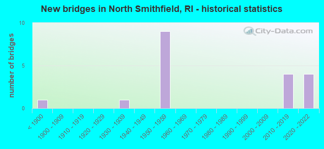
- New bridges - historical statistics
- 1Before 1900
- 11930-1939
- 91950-1959
- 42010-2019
- 42020-2022

- Reconstructed bridges - Historical Statistics
- 31980-1989
- 01990-1999
- 22000-2009
- 12010-2019


- Bridge Condition - Deck
- 30.0%Very good
- 60.0%Good
- 10.0%Satisfactory

- Bridge Condition - Superstructure
- 16.7%Very good
- 41.7%Good
- 33.3%Satisfactory
- 8.3%Fair

- Bridge Condition - Substructure
- 8.3%Very good
- 41.7%Good
- 50.0%Satisfactory

- Bridge Condition - Channel
- 66.7%Good
- 33.3%Satisfactory
Find on map >> Show street view
Structure Number: 44, Location: 0.1 Mi N of JCT RI 138 (Lat: 41.515678, Lng: -71.703497), Route carried "on" structure: City street , Year Built: 1932, Year Reconstructed: 2011, Status: Open, Structure Length: 2.15m (7.05ft), Average Daily Traffic: 1,629 (year 2021), Truck Traffic: 7%, Average Future Daily Traffic: 1,792 (year 2041), Design Load: HS 25 or greater, Features Intersected: WOOD RIVER, Facility Carried by Structure: BRIDGE ST
Minimum Vertical Clearance: 30+ m (98+ ft), Kilometerpoint: 0.098, Lanes on structure: 2, Owner: State Highway Agency, Approaching Roadway Width: 7.9m (25.9ft), Material/Design: Prestressed concrete, Design/Construction: Box Beam or Girders - Multiple, Number Of Spans In Main Unit: 1, Length of Maximum Span: 20.3m (66.6ft), Curb or Sidewalk Widths: Left: 0.0m, Right: 1.5m (4.9ft), Curb-To-Curb Width: 7.9m (25.9ft), Out-to-Out Width: 10.5m (34.4ft)
Condition: Deck: Good, Superstructure: Good, Substructure: Good, Channel: Good, Operating Rating: 96.2 metric tons, Method Used To Determine Operating Rating: Load and Resistance Factor Rating (LRFR) rating reported by rating factor(RF) method using HL-93 loadings, Inventory Rating: 74.2 metric tons, Method Used To Determine Inventory Rating: Load and Resistance Factor Rating (LRFR) rating reported by rating factor(RF) method using HL-93 loadings, Structural Evaluation: Better than present minimum criteria, Deck Geometry: Meets minimum limits, Waterway Adequacy: Superior to present desirable criteria, Approach Roadway Alignment: Equal to present minimum criteria, Length Of Structure Improvement: 1.37m (4.49ft), Designated Inspection Frequency: Every 24 months, Inspection Date: June 2021, Bridge Improvement Cost: $410,000, Roadway Improvement Cost: $41,000, Total Project Cost: $615,000, Deck Structure Type: Other, Wearing Surface/Protective System: Wearing Surface: Bituminous, Membrane: Preformed Fabric, Deck Protection: Epoxy Coated Reinforcing
Find on map >> Show street view
Structure Number: 273, Location: 0.7 Mi E of JCT RI 102 (Lat: 41.999242, Lng: -71.578972), Route carried "on" structure: State highway 5, Year Built: 1855, Status: Open, Structure Length: 4.99m (16.37ft), Average Daily Traffic: 5,430 (year 2021), Truck Traffic: 4%, Average Future Daily Traffic: 5,973 (year 2041), Design Load: H 20, Features Intersected: BRANCH RIVER
Minimum Vertical Clearance: 30+ m (98+ ft), Kilometerpoint: 39.302, Lanes on structure: 2, Owner: State Highway Agency, Approaching Roadway Width: 7.9m (25.9ft), Skew: 1 degrees, Material/Design: Prestressed concrete, Design/Construction: Slab, Number Of Spans In Main Unit: 1, Length of Maximum Span: 49.9m (163.7ft), Curb or Sidewalk Widths: Left: 1.5m (4.9ft), Right: 1.5m (4.9ft), Curb-To-Curb Width: 7.9m (25.9ft), Out-to-Out Width: 13.2m (43.3ft)
Condition: Deck: Good, Superstructure: Satisfactory, Substructure: Satisfactory, Channel: Satisfactory, Structural Evaluation: Equal to present minimum criteria, Deck Geometry: High priority of replacement, Waterway Adequacy: Superior to present desirable criteria, Approach Roadway Alignment: Meets minimum limits, Length Of Structure Improvement: 2.62m (8.60ft), Designated Inspection Frequency: Every 24 months, Inspection Date: May 2021, Bridge Improvement Cost: $1,123,000, Roadway Improvement Cost: $112,000, Total Project Cost: $1,684,000, Deck Structure Type: Concrete Precast Panels, Wearing Surface/Protective System: Wearing Surface: Bituminous, Membrane: Other
Find on map >> Show street view
Structure Number: 44, Location: 1.2 Mi S of JCT RI 104 (Lat: 41.970314, Lng: -71.508717), Route carried "on" structure: State highway 146, Year Built: 1958, Year Reconstructed: 1987, Status: Open, Structure Length: 2.38m (7.81ft), Average Daily Traffic: 42,500 (year 2021), Truck Traffic: 10%, Average Future Daily Traffic: 46,750 (year 2041), Design Load: HS 20, Features Intersected: RI 146A N SMITHFIELD EXP
Minimum Vertical Clearance: 30+ m (98+ ft), Kilometerpoint: 17.484, Lanes on structure: 2, Lanes under structure: 2, Base Highway Network: Yes, Owner: State Highway Agency, Approaching Roadway Width: 11.6m (38.1ft), Skew: 4 degrees, Material/Design: Concrete, Design/Construction: Frame, Number Of Spans In Main Unit: 1, Length of Maximum Span: 21.3m (69.9ft), Curb-To-Curb Width: 11.3m (37.1ft), Out-to-Out Width: 13.3m (43.6ft)
Condition: Deck: Good, Superstructure: Fair, Substructure: Satisfactory, Operating Rating: 51.2 metric tons, Method Used To Determine Operating Rating: Load and Resistance Factor Rating (LRFR) rating reported by rating factor(RF) method using HL-93 loadings, Inventory Rating: 39.5 metric tons, Method Used To Determine Inventory Rating: Load and Resistance Factor Rating (LRFR) rating reported by rating factor(RF) method using HL-93 loadings, Structural Evaluation: Somewhat better than minimum adequacy, Deck Geometry: Somewhat better than minimum adequacy, Underclear: Equal to present minimum criteria, Approach Roadway Alignment: Meets minimum limits, Length Of Structure Improvement: 2.38m (7.81ft), Designated Inspection Frequency: Every 24 months, Inspection Date: July 2021, Bridge Improvement Cost: $2,944,000, Roadway Improvement Cost: $294,000, Total Project Cost: $4,416,000, Wearing Surface/Protective System: Wearing Surface: Bituminous
Find on map >> Show street view
Structure Number: 4415, Location: 1.2 Mi N of JCT RI 146A (Lat: 41.974853, Lng: -71.528919), Route carried "on" structure: State highway 146, Year Built: 2020, Status: Open, Structure Length: 2.77m (9.09ft), Average Daily Traffic: 20,852 (year 2017), Truck Traffic: 5%, Average Future Daily Traffic: 25,477 (year 2037), Design Load: HL 93, Features Intersected: RI 104 FARNUM PIKE
Minimum Vertical Clearance: 30+ m (98+ ft), Kilometerpoint: 19.236, Lanes on structure: 2, Lanes under structure: 2, Base Highway Network: Yes, Owner: State Highway Agency, Approaching Roadway Width: 12.5m (41.0ft), Skew: 2 degrees, Material/Design: Steel, Design/Construction: Stringer/Multi-beam, Number Of Spans In Main Unit: 1, Length of Maximum Span: 26.2m (86.0ft), Curb-To-Curb Width: 12.3m (40.4ft), Out-to-Out Width: 13.4m (44.0ft)
Condition: Deck: Very good, Superstructure: Very good, Substructure: Very good, Operating Rating: 50.5 metric tons, Method Used To Determine Operating Rating: Load and Resistance Factor Rating (LRFR) rating reported by rating factor(RF) method using HL-93 loadings, Inventory Rating: 38.9 metric tons, Method Used To Determine Inventory Rating: Load and Resistance Factor Rating (LRFR) rating reported by rating factor(RF) method using HL-93 loadings, Structural Evaluation: Equal to present desirable criteria, Deck Geometry: Better than present minimum criteria, Underclear: High priority of corrective action, Approach Roadway Alignment: Equal to present minimum criteria, Length Of Structure Improvement: 2.50m (8.20ft), Designated Inspection Frequency: Every 24 months, Inspection Date: October 2021, Bridge Improvement Cost: $468,000, Roadway Improvement Cost: $47,000, Total Project Cost: $627,000, Deck Structure Type: Concrete Cast-file-Place, Wearing Surface/Protective System: Wearing Surface: Bituminous, Membrane: Other, Deck Protection: Galvanized Reinforcing
Find on map >> Show street view
Structure Number: 4417, Location: 1.2 Mi N of JCT RI 146A (Lat: 41.974711, Lng: -71.529100), Route carried "on" structure: State highway 146, Year Built: 2021, Status: Open, Structure Length: 2.77m (9.09ft), Average Daily Traffic: 22,771 (year 2017), Truck Traffic: 5%, Average Future Daily Traffic: 27,823 (year 2037), Design Load: HL 93, Features Intersected: RI 104 FARNUM PIKE
Minimum Vertical Clearance: 30+ m (98+ ft), Kilometerpoint: 6.714, Lanes on structure: 2, Lanes under structure: 2, Base Highway Network: Yes, Owner: State Highway Agency, Approaching Roadway Width: 12.3m (40.4ft), Skew: 2 degrees, Material/Design: Steel, Design/Construction: Stringer/Multi-beam, Number Of Spans In Main Unit: 1, Length of Maximum Span: 26.2m (86.0ft), Curb-To-Curb Width: 12.3m (40.4ft), Out-to-Out Width: 13.4m (44.0ft)
Condition: Deck: Very good, Superstructure: Good, Substructure: Good, Operating Rating: 50.5 metric tons, Method Used To Determine Operating Rating: Load and Resistance Factor Rating (LRFR) rating reported by rating factor(RF) method using HL-93 loadings, Inventory Rating: 38.9 metric tons, Method Used To Determine Inventory Rating: Load and Resistance Factor Rating (LRFR) rating reported by rating factor(RF) method using HL-93 loadings, Structural Evaluation: Better than present minimum criteria, Deck Geometry: Better than present minimum criteria, Underclear: Meets minimum limits, Approach Roadway Alignment: Equal to present minimum criteria, Length Of Structure Improvement: 2.35m (7.71ft), Designated Inspection Frequency: Every 24 months, Inspection Date: July 2021, Bridge Improvement Cost: $1,277,000, Roadway Improvement Cost: $128,000, Total Project Cost: $1,711,000, Deck Structure Type: Concrete Cast-file-Place, Wearing Surface/Protective System: Wearing Surface: Bituminous, Membrane: Other, Deck Protection: Galvanized Reinforcing
Find on map >> Show street view
Structure Number: 4425, Location: 2.5 Mi N of JCT RI 146A (Lat: 41.980783, Lng: -71.541544), Route carried "on" structure: City street , Year Built: 2018, Status: Open, Structure Length: 6.35m (20.83ft), Average Daily Traffic: 672 (year 2021), Truck Traffic: 12%, Average Future Daily Traffic: 739 (year 2041), Design Load: HL 93, Features Intersected: RI 146 N SMITHFIELD EXP, Facility Carried by Structure: WOONSOCKET HILL RD
Minimum Vertical Clearance: 30+ m (98+ ft), Kilometerpoint: 2.082, Lanes on structure: 2, Lanes under structure: 4, Owner: State Highway Agency, Approaching Roadway Width: 9.1m (29.9ft), Material/Design: Steel, Design/Construction: Stringer/Multi-beam, Number Of Spans In Main Unit: 2, Length of Maximum Span: 31.3m (102.7ft), Curb or Sidewalk Widths: Left: 1.8m (5.9ft), Right: 1.8m (5.9ft), Curb-To-Curb Width: 9.1m (29.9ft), Out-to-Out Width: 13.7m (44.9ft)
Condition: Deck: Very good, Superstructure: Very good, Substructure: Good, Operating Rating: 31.1 metric tons, Method Used To Determine Operating Rating: Load and Resistance Factor Rating (LRFR) rating reported by rating factor(RF) method using HL-93 loadings, Inventory Rating: 24.0 metric tons, Method Used To Determine Inventory Rating: Load and Resistance Factor Rating (LRFR) rating reported by rating factor(RF) method using HL-93 loadings, Structural Evaluation: Somewhat better than minimum adequacy, Deck Geometry: Equal to present minimum criteria, Underclear: High priority of corrective action, Approach Roadway Alignment: Equal to present desirable criteria, Length Of Structure Improvement: 5.67m (18.60ft), Designated Inspection Frequency: Every 24 months, Inspection Date: December 2021, Bridge Improvement Cost: $1,640,000, Roadway Improvement Cost: $164,000, Total Project Cost: $2,460,000, Deck Structure Type: Concrete Cast-file-Place, Wearing Surface/Protective System: Wearing Surface: Bituminous, Membrane: Other
Find on map >> Show street view
Structure Number: 443, Location: 2.0 Mi N of JCT RI 104 (Lat: 41.988994, Lng: -71.552131), Route carried "on" structure: State highway 146, Year Built: 1958, Year Reconstructed: 1987, Status: Open, Structure Length: 1.92m (6.30ft), Average Daily Traffic: 5,348 (year 2021), Truck Traffic: 11%, Average Future Daily Traffic: 5,883 (year 2041), Features Intersected: POUND HILL RD
Minimum Vertical Clearance: 30+ m (98+ ft), Kilometerpoint: 21.757, Lanes on structure: 4, Lanes under structure: 2, Base Highway Network: Yes, Owner: State Highway Agency, Approaching Roadway Width: 23.8m (78.1ft), Skew: 22 degrees, Material/Design: Concrete, Design/Construction: Frame, Number Of Spans In Main Unit: 1, Length of Maximum Span: 16.8m (55.1ft), Curb-To-Curb Width: 23.8m (78.1ft), Out-to-Out Width: 32.3m (106.0ft)
Condition: Superstructure: Satisfactory, Substructure: Satisfactory, Operating Rating: 85.2 metric tons, Method Used To Determine Operating Rating: Load and Resistance Factor Rating (LRFR) rating reported by rating factor(RF) method using HL-93 loadings, Inventory Rating: 65.8 metric tons, Method Used To Determine Inventory Rating: Load and Resistance Factor Rating (LRFR) rating reported by rating factor(RF) method using HL-93 loadings, Structural Evaluation: Equal to present minimum criteria, Deck Geometry: Superior to present desirable criteria, Underclear: Meets minimum limits, Approach Roadway Alignment: Equal to present desirable criteria, Length Of Structure Improvement: 1.92m (6.30ft), Designated Inspection Frequency: Every 24 months, Inspection Date: June 2021, Bridge Improvement Cost: $251,000, Roadway Improvement Cost: $25,000, Total Project Cost: $377,000
Find on map >> Show street view
Structure Number: 445, Location: 3.2 Mi N of JCT RI 104 (Lat: 41.996681, Lng: -71.556931), Route carried "on" structure: State highway 146, Year Built: 1959, Status: Open, Structure Length: 2.23m (7.32ft), Average Daily Traffic: 26,951 (year 2015), Truck Traffic: 6%, Average Future Daily Traffic: 32,342 (year 2036), Design Load: HS 20, Features Intersected: BRANCH RIVER
Minimum Vertical Clearance: 30+ m (98+ ft), Kilometerpoint: 22.705, Lanes on structure: 4, Base Highway Network: Yes, Owner: State Highway Agency, Approaching Roadway Width: 23.0m (75.5ft), Skew: 20 degrees, Material/Design: Concrete, Design/Construction: Frame, Number Of Spans In Main Unit: 1, Length of Maximum Span: 19.8m (65.0ft), Curb or Sidewalk Widths: Left: 0.5m (1.6ft), Right: 0.5m (1.6ft), Curb-To-Curb Width: 23.0m (75.5ft), Out-to-Out Width: 31.9m (104.7ft)
Condition: Deck: Good, Superstructure: Satisfactory, Substructure: Satisfactory, Channel: Good, Operating Rating: 57.0 metric tons, Method Used To Determine Operating Rating: Load and Resistance Factor Rating (LRFR) rating reported by rating factor(RF) method using HL-93 loadings, Inventory Rating: 44.1 metric tons, Method Used To Determine Inventory Rating: Load and Resistance Factor Rating (LRFR) rating reported by rating factor(RF) method using HL-93 loadings, Structural Evaluation: Equal to present minimum criteria, Deck Geometry: Superior to present desirable criteria, Waterway Adequacy: Equal to present desirable criteria, Approach Roadway Alignment: Equal to present desirable criteria, Length Of Structure Improvement: 2.23m (7.32ft), Designated Inspection Frequency: Every 24 months, Inspection Date: June 2021, Bridge Improvement Cost: $1,480,000, Roadway Improvement Cost: $148,000, Total Project Cost: $2,219,000, Deck Structure Type: Concrete Cast-file-Place, Wearing Surface/Protective System: Wearing Surface: Bituminous, Membrane: Preformed Fabric
Find on map >> Show street view
Structure Number: 446, Location: 3.7 Mi N of JCT RI 104 (Lat: 42.000125, Lng: -71.558867), Route carried "on" structure: City street , Year Built: 1959, Year Reconstructed: 2010, Status: Open, Structure Length: 6.03m (19.78ft), Average Daily Traffic: 2,920 (year 2021), Truck Traffic: 2%, Average Future Daily Traffic: 3,212 (year 2041), Design Load: HS 25 or greater, Features Intersected: RI 146 N SMITHFIELD EXP, Facility Carried by Structure: SCHOOL ST
Minimum Vertical Clearance: 30+ m (98+ ft), Kilometerpoint: 1.905, Lanes on structure: 2, Lanes under structure: 4, Owner: State Highway Agency, Approaching Roadway Width: 12.2m (40.0ft), Skew: 2 degrees, Material/Design: Steel continuous, Design/Construction: Stringer/Multi-beam, Number Of Spans In Main Unit: 4, Length of Maximum Span: 18.0m (59.1ft), Curb or Sidewalk Widths: Left: 1.8m (5.9ft), Right: 1.8m (5.9ft), Curb-To-Curb Width: 12.2m (40.0ft), Out-to-Out Width: 16.5m (54.1ft)
Condition: Deck: Good, Superstructure: Good, Substructure: Satisfactory, Operating Rating: 70.0 metric tons, Method Used To Determine Operating Rating: Load and Resistance Factor Rating (LRFR) rating reported by rating factor(RF) method using HL-93 loadings, Inventory Rating: 50.2 metric tons, Method Used To Determine Inventory Rating: Load and Resistance Factor Rating (LRFR) rating reported by rating factor(RF) method using HL-93 loadings, Structural Evaluation: Equal to present minimum criteria, Deck Geometry: Equal to present minimum criteria, Underclear: High priority of corrective action, Approach Roadway Alignment: Equal to present desirable criteria, Length Of Structure Improvement: 6.04m (19.82ft), Designated Inspection Frequency: Every 24 months, Inspection Date: November 2021, Bridge Improvement Cost: $3,723,000, Roadway Improvement Cost: $372,000, Total Project Cost: $5,585,000, Deck Structure Type: Concrete Cast-file-Place, Wearing Surface/Protective System: Wearing Surface: Monolithic Concrete, Deck Protection: Epoxy Coated Reinforcing
Find on map >> Show street view
Structure Number: 447, Location: 3.7 Mi N of JCT RI 104 (Lat: 42.002156, Lng: -71.560661), Route carried "on" structure: Alternate State highway 146A, Year Built: 1959, Year Reconstructed: 2009, Status: Open, Structure Length: 4.58m (15.03ft), Average Daily Traffic: 15,600 (year 2021), Truck Traffic: 5%, Average Future Daily Traffic: 17,160 (year 2041), Design Load: HL 93, Features Intersected: RI 146 N SMITHFIELD EXP
Minimum Vertical Clearance: 30+ m (98+ ft), Kilometerpoint: 6.479, Lanes on structure: 2, Lanes under structure: 4, Base Highway Network: Yes, Owner: State Highway Agency, Approaching Roadway Width: 12.2m (40.0ft), Skew: 4 degrees, Material/Design: Steel continuous, Design/Construction: Stringer/Multi-beam, Number Of Spans In Main Unit: 2, Length of Maximum Span: 21.9m (71.9ft), Curb or Sidewalk Widths: Left: 1.8m (5.9ft), Right: 1.8m (5.9ft), Curb-To-Curb Width: 12.2m (40.0ft), Out-to-Out Width: 16.5m (54.1ft)
Condition: Deck: Satisfactory, Superstructure: Good, Substructure: Good, Operating Rating: 30.8 metric tons, Method Used To Determine Operating Rating: Load and Resistance Factor Rating (LRFR) rating reported by rating factor(RF) method using HL-93 loadings, Inventory Rating: 23.7 metric tons, Method Used To Determine Inventory Rating: Load and Resistance Factor Rating (LRFR) rating reported by rating factor(RF) method using HL-93 loadings, Structural Evaluation: Somewhat better than minimum adequacy, Deck Geometry: Somewhat better than minimum adequacy, Underclear: Meets minimum limits, Approach Roadway Alignment: Equal to present desirable criteria, Length Of Structure Improvement: 2.99m (9.81ft), Designated Inspection Frequency: Every 24 months, Inspection Date: November 2021, Bridge Improvement Cost: $2,363,000, Roadway Improvement Cost: $236,000, Total Project Cost: $3,544,000, Deck Structure Type: Concrete Cast-file-Place, Wearing Surface/Protective System: Wearing Surface: Bituminous, Membrane: Built-up, Deck Protection: Epoxy Coated Reinforcing
Find on map >> Show street view
Structure Number: 448, Location: 1.0 Mi S of Mass Line (Lat: 42.009161, Lng: -71.574597), Route carried "on" structure: State highway 146, Year Built: 1959, Year Reconstructed: 1987, Status: Open, Structure Length: 1.30m (4.27ft), Average Daily Traffic: 34,375 (year 2021), Truck Traffic: 11%, Average Future Daily Traffic: 37,813 (year 2041), Design Load: HS 20, Features Intersected: Old Great Road
Minimum Vertical Clearance: 30+ m (98+ ft), Kilometerpoint: 24.806, Lanes on structure: 4, Lanes under structure: 2, Base Highway Network: Yes, Owner: State Highway Agency, Approaching Roadway Width: 22.6m (74.1ft), Skew: 20 degrees, Material/Design: Concrete, Design/Construction: Frame, Number Of Spans In Main Unit: 1, Length of Maximum Span: 11.1m (36.4ft), Curb or Sidewalk Widths: Left: 0.5m (1.6ft), Right: 0.5m (1.6ft), Curb-To-Curb Width: 22.6m (74.1ft), Out-to-Out Width: 30.8m (101.0ft)
Condition: Superstructure: Satisfactory, Substructure: Satisfactory, Operating Rating: 57.7 metric tons, Method Used To Determine Operating Rating: Load and Resistance Factor Rating (LRFR) rating reported by rating factor(RF) method using HL-93 loadings, Inventory Rating: 44.4 metric tons, Method Used To Determine Inventory Rating: Load and Resistance Factor Rating (LRFR) rating reported by rating factor(RF) method using HL-93 loadings, Structural Evaluation: Equal to present minimum criteria, Deck Geometry: Superior to present desirable criteria, Underclear: High priority of corrective action, Approach Roadway Alignment: Better than present minimum criteria, Length Of Structure Improvement: 1.37m (4.49ft), Designated Inspection Frequency: Every 24 months, Inspection Date: November 2021, Bridge Improvement Cost: $909,000, Roadway Improvement Cost: $91,000, Total Project Cost: $1,364,000, Deck Structure Type: Concrete Cast-file-Place, Wearing Surface/Protective System: Wearing Surface: Bituminous, Membrane: Other
Find on map >> Show street view
Structure Number: 4495, Location: 0.1 Mi S of JCT MASS LINE (Lat: 42.012569, Lng: -71.583831), Route carried "on" structure: City street 5, Year Built: 2017, Status: Open, Structure Length: 5.68m (18.64ft), Average Daily Traffic: 2,285 (year 2021), Truck Traffic: 5%, Average Future Daily Traffic: 2,514 (year 2041), Design Load: HL 93, Features Intersected: RI 146 N SMITHFIELD EXP
Minimum Vertical Clearance: 30+ m (98+ ft), Kilometerpoint: 41.212, Lanes on structure: 2, Lanes under structure: 4, Owner: State Highway Agency, Approaching Roadway Width: 12.2m (40.0ft), Material/Design: Steel continuous, Design/Construction: Stringer/Multi-beam, Number Of Spans In Main Unit: 4, Length of Maximum Span: 15.8m (51.8ft), Curb or Sidewalk Widths: Left: 1.8m (5.9ft), Right: 1.8m (5.9ft), Curb-To-Curb Width: 12.2m (40.0ft), Out-to-Out Width: 16.5m (54.1ft)
Condition: Deck: Good, Superstructure: Good, Substructure: Good, Operating Rating: 83.3 metric tons, Method Used To Determine Operating Rating: Load and Resistance Factor Rating (LRFR) rating reported by rating factor(RF) method using HL-93 loadings, Inventory Rating: 64.2 metric tons, Method Used To Determine Inventory Rating: Load and Resistance Factor Rating (LRFR) rating reported by rating factor(RF) method using HL-93 loadings, Structural Evaluation: Better than present minimum criteria, Deck Geometry: Equal to present minimum criteria, Underclear: Meets minimum limits, Approach Roadway Alignment: Equal to present desirable criteria, Length Of Structure Improvement: 5.64m (18.50ft), Designated Inspection Frequency: Every 24 months, Inspection Date: November 2021, Bridge Improvement Cost: $1,996,000, Roadway Improvement Cost: $200,000, Total Project Cost: $2,994,000, Deck Structure Type: Concrete Cast-file-Place, Wearing Surface/Protective System: Wearing Surface: Bituminous, Membrane: Preformed Fabric, Deck Protection: Galvanized Reinforcing
Find on map >> Show street view
Structure Number: 44, Location: 1.2 Mi S of JCT RI 104 (Lat: 41.970314, Lng: -71.508717), Route carried "under" structure: Ramp State highway 146, Year Built: 1958, Structure Length: 0. m, Average Daily Traffic: 42,500 (year 2021), Truck Traffic: 10%, Features Intersected: RI 146A N SMITHFIELD EXP
Minimum Vertical Clearance: 4.39m (14.40ft), Kilometerpoint: 0.000, Lanes on structure: 2, Lanes under structure: 1, Material/Design: Concrete, Design/Construction: Frame, Length of Maximum Span: 21.3m (69.9ft)
Find on map >> Show street view
Structure Number: 4415, Location: 1.2 Mi N of JCT RI 146A (Lat: 41.974853, Lng: -71.528919), Route carried "under" structure: Alternate State highway 104, Year Built: 2020, Structure Length: 0. m, Average Daily Traffic: 2,905 (year 2017), Truck Traffic: 3%, Features Intersected: RI 104 FARNUM PIKE, Facility Carried by Structure: RI 146 NB
Minimum Vertical Clearance: 5.61m (18.41ft), Kilometerpoint: 0.000, Lanes on structure: 2, Lanes under structure: 2, Material/Design: Steel, Design/Construction: Stringer/Multi-beam, Length of Maximum Span: 26.2m (86.0ft)
Find on map >> Show street view
Structure Number: 4417, Location: 1.2 Mi N of JCT RI 146A (Lat: 41.974711, Lng: -71.529100), Route carried "under" structure: State highway 104, Year Built: 2021, Structure Length: 0. m, Average Daily Traffic: 3,551 (year 2017), Truck Traffic: 3%, Features Intersected: RI 104 FARNUM PIKE, Facility Carried by Structure: RI 146 SB
Minimum Vertical Clearance: 5.04m (16.54ft), Kilometerpoint: 6.714, Lanes on structure: 2, Lanes under structure: 2, Material/Design: Steel, Design/Construction: Stringer/Multi-beam, Length of Maximum Span: 26.2m (86.0ft)
Find on map >> Show street view
Structure Number: 4425, Location: 2.5 Mi N of JCT RI 146A (Lat: 41.980783, Lng: -71.541544), Route carried "under" structure: State highway 146, Year Built: 2018, Structure Length: 0. m, Average Daily Traffic: 672 (year 2021), Truck Traffic: 12%, Features Intersected: RI 146 N SMITHFIELD EXP, Facility Carried by Structure: WOONSOCKET HILL RD
Minimum Vertical Clearance: 6.25m (20.51ft), Kilometerpoint: 0.000, Lanes on structure: 2, Lanes under structure: 4, Material/Design: Steel, Design/Construction: Stringer/Multi-beam, Length of Maximum Span: 31.3m (102.7ft)
Find on map >> Show street view
Structure Number: 446, Location: 3.7 Mi N of JCT RI 104 (Lat: 42.000125, Lng: -71.558867), Route carried "under" structure: State highway 146, Year Built: 1959, Structure Length: 0. m, Average Daily Traffic: 2,920 (year 2021), Truck Traffic: 2%, Features Intersected: RI 146 N SMITHFIELD EXP, Facility Carried by Structure: SCHOOL ST
Minimum Vertical Clearance: 4.50m (14.76ft), Kilometerpoint: 0.000, Lanes on structure: 2, Lanes under structure: 4, Material/Design: Steel continuous, Design/Construction: Stringer/Multi-beam, Length of Maximum Span: 18.0m (59.1ft)
Find on map >> Show street view
Structure Number: 447, Location: 3.7 Mi N of JCT RI 104 (Lat: 42.002156, Lng: -71.560661), Route carried "under" structure: Alternate State highway 146, Year Built: 1959, Structure Length: 0. m, Average Daily Traffic: 15,600 (year 2021), Truck Traffic: 5%, Features Intersected: RI 146 N SMITHFIELD EXP
Minimum Vertical Clearance: 5.08m (16.67ft), Kilometerpoint: 0.000, Lanes on structure: 2, Lanes under structure: 4, Material/Design: Steel continuous, Design/Construction: Stringer/Multi-beam, Length of Maximum Span: 21.9m (71.9ft)
Find on map >> Show street view
Structure Number: 4495, Location: 0.1 Mi S of JCT MASS LINE (Lat: 42.012569, Lng: -71.583831), Route carried "under" structure: State highway 146, Year Built: 2017, Structure Length: 0. m, Average Daily Traffic: 2,285 (year 2021), Truck Traffic: 5%, Features Intersected: RI 146 N SMITHFIELD EXP, Facility Carried by Structure: RI 5 (CENTRAL ST)
Minimum Vertical Clearance: 4.50m (14.76ft), Kilometerpoint: 0.000, Lanes on structure: 2, Lanes under structure: 4, Material/Design: Steel continuous, Design/Construction: Stringer/Multi-beam, Length of Maximum Span: 15.8m (51.8ft)