Bridge Statistics for North Chicago, Illinois (IL)
Condition, Traffic, Stress, Structural Evaluation, Project Costs
- National Bridge Inventory (NBI) Statistics
- 15Number of bridges
- 164ft / 49.8mTotal length
- $198,000Total costs
- 106,530Total average daily traffic
- 4,033Total average daily truck traffic
- National Bridge Inventory (NBI) Registered Bridges for North Chicago
- No street view available for this location
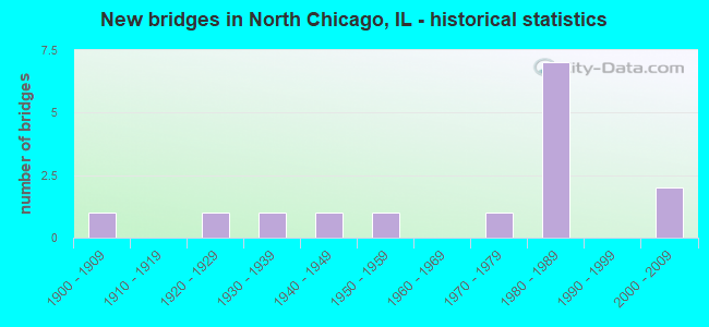
- New bridges - historical statistics
- 11900-1909
- 11920-1929
- 11930-1939
- 11940-1949
- 11950-1959
- 11970-1979
- 71980-1989
- 22000-2009

- Reconstructed bridges - Historical Statistics
- 11970-1979
- 11980-1989
- 11990-1999


- Bridge Condition - Deck
- 37.5%Good
- 50.0%Satisfactory
- 12.5%Fair

- Bridge Condition - Superstructure
- 37.5%Good
- 37.5%Satisfactory
- 12.5%Fair
- 12.5%Poor

- Bridge Condition - Substructure
- 12.5%Very good
- 62.5%Good
- 12.5%Satisfactory
- 12.5%Fair

- Bridge Condition - Channel
- 16.7%Very good
- 33.3%Good
- 33.3%Satisfactory
- 16.7%Fair
Find on map >> Show street view
Structure Number: 1IL00S1, Location: 0.5 KM E OF SHERIDAN RD (Lat: 42.312081, Lng: -87.842444), Route carried "on" structure: Other road , Year Built: 2005, Status: Open, Structure Length: 5.51m (18.08ft), Average Daily Traffic: 12,075 (year 2008), Truck Traffic: 2%, Average Future Daily Traffic: 13,325 (year 2035), Features Intersected: PETTIBONE CK/ CRUSLEY DR, Facility Carried by Structure: FARRAGUT AVENUE
Minimum Vertical Clearance: 30+ m (98+ ft), Kilometerpoint: 0.000, Lanes on structure: 2, Lanes under structure: 1, Owner: Navy/Marines, Approaching Roadway Width: 11.6m (38.1ft), Material/Design: Steel continuous, Design/Construction: Stringer/Multi-beam, Number Of Spans In Main Unit: 3, Length of Maximum Span: 24.4m (80.1ft), Curb or Sidewalk Widths: Left: 2.1m (6.9ft), Right: 2.1m (6.9ft), Curb-To-Curb Width: 11.6m (38.1ft), Out-to-Out Width: 16.5m (54.1ft)
Condition: Deck: Good, Superstructure: Good, Substructure: Good, Channel: Good, Operating Rating: 54.7 metric tons, Method Used To Determine Operating Rating: Load Factor (LF), Inventory Rating: 32.7 metric tons, Method Used To Determine Inventory Rating: Load Factor (LF), Structural Evaluation: Better than present minimum criteria, Deck Geometry: Somewhat better than minimum adequacy, Waterway Adequacy: Equal to present desirable criteria, Approach Roadway Alignment: Equal to present desirable criteria, Length Of Structure Improvement: 5.51m (18.08ft), Designated Inspection Frequency: Every 24 months, Inspection Date: July 2020, Bridge Improvement Cost: $31,000, Roadway Improvement Cost: $38,000, Total Project Cost: $69,000 ( Estimate for 2020), Deck Structure Type: Concrete Cast-file-Place, Wearing Surface/Protective System: Wearing Surface: Monolithic Concrete, Deck Protection: Epoxy Coated Reinforcing
Find on map >> Show street view
Structure Number: 1IL00S9, Location: 0.5 KM S OF DECATUR AVE (Lat: 42.309106, Lng: -87.838786), Route carried "on" structure: Other road , Year Built: 1926, Year Reconstructed: 1985, Status: Posted for load, Structure Length: 10.52m (34.51ft), Average Daily Traffic: 1,260 (year 2008), Truck Traffic: 5%, Average Future Daily Traffic: 1,260 (year 2035), Features Intersected: PETTIBONE CREEK, Facility Carried by Structure: SAMPSON STREET
Minimum Vertical Clearance: 30+ m (98+ ft), Kilometerpoint: 0.000, Lanes on structure: 1, Owner: Navy/Marines, Approaching Roadway Width: 8.6m (28.2ft), Material/Design: Concrete, Design/Construction: Arch - Deck, Number Of Spans In Main Unit: 3, Length of Maximum Span: 36.6m (120.1ft), Curb or Sidewalk Widths: Left: 1.5m (4.9ft), Right: 1.3m (4.3ft), Curb-To-Curb Width: 8.3m (27.2ft), Out-to-Out Width: 12.2m (40.0ft)
Condition: Deck: Fair, Superstructure: Poor, Substructure: Fair, Channel: Satisfactory, Operating Rating: 10.9 metric tons, Method Used To Determine Operating Rating: Field evaluation and documented engineering judgment, Inventory Rating: 10.9 metric tons, Method Used To Determine Inventory Rating: Field evaluation and documented engineering judgment, Structural Evaluation: High priority of replacement, Deck Geometry: Meets minimum limits, Waterway Adequacy: Equal to present desirable criteria, Approach Roadway Alignment: Equal to present desirable criteria, Bridge Posting: Required (Relationship of Operating Rating to Maximum Legal Load: 30.0 - 39.9% below), Length Of Structure Improvement: 10.52m (34.51ft), Designated Inspection Frequency: Every 24 months, Inspection Date: July 2020, Bridge Improvement Cost: $2,000, Roadway Improvement Cost: $35,000, Total Project Cost: $37,000 ( Estimate for 2020), Deck Structure Type: Other, Wearing Surface/Protective System: Wearing Surface: Bituminous
Find on map >> Show street view
Structure Number: 1IL0S12, Location: 0.01KM S OF CROSLEY DR (Lat: 42.309319, Lng: -87.836211), Route carried "on" structure: Other road , Year Built: 1938, Year Reconstructed: 1995, Status: Posted for load, Structure Length: 0.90m (2.95ft), Average Daily Traffic: 210 (year 2008), Truck Traffic: 5%, Average Future Daily Traffic: 308 (year 2035), Design Load: HS 20, Features Intersected: PETTIBONE CREEK, Facility Carried by Structure: 10TH STREET
Minimum Vertical Clearance: 30+ m (98+ ft), Kilometerpoint: 0.000, Lanes on structure: 2, Owner: Navy/Marines, Approaching Roadway Width: 6.1m (20.0ft), Skew: 1 degrees, Material/Design: Prestressed concrete, Design/Construction: Slab, Number Of Spans In Main Unit: 1, Length of Maximum Span: 8.4m (27.6ft), Curb-To-Curb Width: 5.3m (17.4ft), Out-to-Out Width: 6.4m (21.0ft)
Condition: Deck: Satisfactory, Superstructure: Fair, Substructure: Satisfactory, Channel: Good, Operating Rating: 54.1 metric tons, Method Used To Determine Operating Rating: Load Factor (LF), Inventory Rating: 32.4 metric tons, Method Used To Determine Inventory Rating: Load Factor (LF), Structural Evaluation: Somewhat better than minimum adequacy, Deck Geometry: High priority of replacement, Waterway Adequacy: Equal to present desirable criteria, Approach Roadway Alignment: Equal to present minimum criteria, Length Of Structure Improvement: 0.90m (2.95ft), Designated Inspection Frequency: Every 24 months, Inspection Date: July 2020, Bridge Improvement Cost: $5,000, Roadway Improvement Cost: $37,000, Total Project Cost: $42,000 ( Estimate for 2020), Deck Structure Type: Concrete Precast Panels, Wearing Surface/Protective System: Wearing Surface: Bituminous
Find on map >> Show street view
Structure Number: 1IL114H, Location: 0.6 KM E OF SHERIDAN RD (Lat: 42.306453, Lng: -87.841083), Route carried "on" structure: Other road , Year Built: 2009, Status: Posted for load, Structure Length: 8.35m (27.40ft), Average Daily Traffic: 4,725 (year 2008), Truck Traffic: 5%, Average Future Daily Traffic: 5,000 (year 2039), Design Load: HS 20, Features Intersected: PETTIBONE CR, ACCESS RD, Facility Carried by Structure: "D" STREET
Minimum Vertical Clearance: 30+ m (98+ ft), Kilometerpoint: 0.000, Lanes on structure: 2, Owner: Navy/Marines, Approaching Roadway Width: 7.3m (24.0ft), Material/Design: Prestressed concrete, Design/Construction: Stringer/Multi-beam, Number Of Spans In Main Unit: 3, Length of Maximum Span: 27.4m (89.9ft), Curb or Sidewalk Widths: Left: 1.8m (5.9ft), Right: 1.8m (5.9ft), Curb-To-Curb Width: 7.9m (25.9ft), Out-to-Out Width: 12.2m (40.0ft)
Condition: Deck: Good, Superstructure: Good, Substructure: Very good, Channel: Very good, Operating Rating: 71.2 metric tons, Method Used To Determine Operating Rating: Load Factor (LF), Inventory Rating: 42.6 metric tons, Method Used To Determine Inventory Rating: Load Factor (LF), Structural Evaluation: Better than present minimum criteria, Deck Geometry: High priority of corrective action, Approach Roadway Alignment: Equal to present desirable criteria, Length Of Structure Improvement: 8.22m (26.97ft), Designated Inspection Frequency: Every 24 months, Inspection Date: July 2020, Bridge Improvement Cost: $3,000, Roadway Improvement Cost: $38,000, Total Project Cost: $41,000 ( Estimate for 2020), Deck Structure Type: Concrete Cast-file-Place, Wearing Surface/Protective System: Wearing Surface: Monolithic Concrete, Deck Protection: Epoxy Coated Reinforcing
Find on map >> Show street view
Structure Number: 1IL2212, Location: 50M E. OF MISSISSIPPI ST. (Lat: 42.307278, Lng: -87.872528), Route carried "on" structure: Other road , Year Built: 1957, Status: Open, Structure Length: 0.63m (2.07ft), Average Daily Traffic: 210 (year 2008), Truck Traffic: 5%, Average Future Daily Traffic: 315 (year 2039), Features Intersected: CREEK, Facility Carried by Structure: CONNECICUT AVE
Minimum Vertical Clearance: 30+ m (98+ ft), Kilometerpoint: 0.000, Lanes on structure: 2, Owner: Navy/Marines, Approaching Roadway Width: 7.2m (23.6ft), Material/Design: Concrete, Design/Construction: Culvert, Number Of Spans In Main Unit: 2, Length of Maximum Span: 3.0m (9.8ft), Curb or Sidewalk Widths: Left: 1.5m (4.9ft), Right: 0.3m (1.0ft)
Condition: Channel: Fair, Culverts: Satisfactory, Operating Rating: 36.2 metric tons, Method Used To Determine Operating Rating: Field evaluation and documented engineering judgment, Inventory Rating: 32.6 metric tons, Method Used To Determine Inventory Rating: Field evaluation and documented engineering judgment, Structural Evaluation: Equal to present minimum criteria, Waterway Adequacy: Better than present minimum criteria, Approach Roadway Alignment: Equal to present desirable criteria, Length Of Structure Improvement: 0.63m (2.07ft), Designated Inspection Frequency: Every 24 months, Inspection Date: July 2020, Roadway Improvement Cost: $9,000, Total Project Cost: $9,000 ( Estimate for 2020)
Find on map >> Show street view
Structure Number: 490161, Location: 0.05 E OF AMSTUTZ (Lat: 42.307769, Lng: -87.846064), Route carried "on" structure: Other road , Year Built: 1989, Status: Open, Structure Length: 5.54m (18.18ft), Average Daily Traffic: 3,900 (year 2021), Truck Traffic: 4%, Average Future Daily Traffic: 4,619 (year 2032), Design Load: HS 20, Features Intersected: BUCKLEY ROAD, Facility Carried by Structure: SHERIDAN RD
Minimum Vertical Clearance: 30+ m (98+ ft), Kilometerpoint: 1.802, Lanes on structure: 5, Lanes under structure: 4, Base Highway Network: Yes, Owner: State Highway Agency, Approaching Roadway Width: 20.7m (67.9ft), Material/Design: Prestressed concrete continuous, Design/Construction: Stringer/Multi-beam, Number Of Spans In Main Unit: 3, Length of Maximum Span: 25.9m (85.0ft), Curb or Sidewalk Widths: Left: 3.0m (9.8ft), Right: 0.0m, Curb-To-Curb Width: 20.7m (67.9ft), Out-to-Out Width: 24.9m (81.7ft)
Condition: Deck: Satisfactory, Superstructure: Satisfactory, Substructure: Good, Operating Rating: 77.1 metric tons, Method Used To Determine Operating Rating: Load Factor (LF) rating reported by rating factor (RF) method using MS18 loading, Inventory Rating: 42.1 metric tons, Method Used To Determine Inventory Rating: Load Factor (LF) rating reported by rating factor (RF) method using MS18 loading, Structural Evaluation: Equal to present minimum criteria, Deck Geometry: Somewhat better than minimum adequacy, Underclear: Meets minimum limits, Approach Roadway Alignment: Equal to present desirable criteria, Designated Inspection Frequency: Every 24 months, Inspection Date: November 2021, Deck Structure Type: Concrete Cast-file-Place, Wearing Surface/Protective System: Wearing Surface: Latex Concrete, Deck Protection: Epoxy Coated Reinforcing
Find on map >> Show street view
Structure Number: 490162, Location: 0.5 M N OF IL 137 (Lat: 42.315381, Lng: -87.844139), Route carried "on" structure: Other road , Year Built: 1989, Status: Open, Structure Length: 5.54m (18.18ft), Average Daily Traffic: 6,000 (year 2021), Truck Traffic: 5%, Average Future Daily Traffic: 4,619 (year 2032), Design Load: HS 20, Features Intersected: 24TH ST, Facility Carried by Structure: SHERIDAN RD
Minimum Vertical Clearance: 30+ m (98+ ft), Kilometerpoint: 0.949, Lanes on structure: 4, Lanes under structure: 2, Base Highway Network: Yes, Owner: State Highway Agency, Approaching Roadway Width: 20.7m (67.9ft), Material/Design: Prestressed concrete continuous, Design/Construction: Stringer/Multi-beam, Number Of Spans In Main Unit: 3, Length of Maximum Span: 27.4m (89.9ft), Curb or Sidewalk Widths: Left: 3.0m (9.8ft), Right: 0.0m, Curb-To-Curb Width: 20.7m (67.9ft), Out-to-Out Width: 25.0m (82.0ft)
Condition: Deck: Satisfactory, Superstructure: Good, Substructure: Good, Operating Rating: 79.1 metric tons, Method Used To Determine Operating Rating: Load Factor (LF) rating reported by rating factor (RF) method using MS18 loading, Inventory Rating: 47.3 metric tons, Method Used To Determine Inventory Rating: Load Factor (LF) rating reported by rating factor (RF) method using MS18 loading, Structural Evaluation: Better than present minimum criteria, Deck Geometry: Superior to present desirable criteria, Underclear: Somewhat better than minimum adequacy, Approach Roadway Alignment: Better than present minimum criteria, Designated Inspection Frequency: Every 48 months, Inspection Date: November 2021, Deck Structure Type: Concrete Cast-file-Place, Wearing Surface/Protective System: Deck Protection: Epoxy Coated Reinforcing
Find on map >> Show street view
Structure Number: 490163, Location: 0.53 M N OF IL 137 (Lat: 42.315608, Lng: -87.845022), Route carried "on" structure: State highway 137, Year Built: 1989, Status: Open, Structure Length: 3.13m (10.27ft), Average Daily Traffic: 14,600 (year 2021), Truck Traffic: 3%, Average Future Daily Traffic: 11,186 (year 2032), Design Load: HS 20, Features Intersected: 24TH ST
Minimum Vertical Clearance: 30+ m (98+ ft), Kilometerpoint: 17.445, Lanes on structure: 4, Lanes under structure: 4, Base Highway Network: Yes, Owner: State Highway Agency, Approaching Roadway Width: 26.8m (87.9ft), Skew: 30 degrees, Material/Design: Steel continuous, Design/Construction: Stringer/Multi-beam, Number Of Spans In Main Unit: 1, Length of Maximum Span: 30.5m (100.1ft), Curb-To-Curb Width: 26.5m (86.9ft), Out-to-Out Width: 28.4m (93.2ft)
Condition: Deck: Good, Superstructure: Satisfactory, Substructure: Good, Operating Rating: 71.3 metric tons, Method Used To Determine Operating Rating: Load Factor (LF) rating reported by rating factor (RF) method using MS18 loading, Inventory Rating: 42.4 metric tons, Method Used To Determine Inventory Rating: Load Factor (LF) rating reported by rating factor (RF) method using MS18 loading, Structural Evaluation: Equal to present minimum criteria, Deck Geometry: Superior to present desirable criteria, Underclear: Equal to present minimum criteria, Approach Roadway Alignment: Equal to present desirable criteria, Designated Inspection Frequency: Every 24 months, Inspection Date: July 2021, Deck Structure Type: Concrete Cast-file-Place, Wearing Surface/Protective System: Deck Protection: Epoxy Coated Reinforcing
Find on map >> Show street view
Structure Number: 492011, Location: 0.18 M E US 41 (Lat: 42.308722, Lng: -87.872461), Route carried "on" structure: State highway 137, Year Built: 1942, Year Reconstructed: 1976, Status: Open, Structure Length: 0.63m (2.07ft), Average Daily Traffic: 18,700 (year 2021), Truck Traffic: 4%, Average Future Daily Traffic: 20,034 (year 2032), Design Load: HS 20, Features Intersected: SKOKIE RIVER
Minimum Vertical Clearance: 30+ m (98+ ft), Kilometerpoint: 14.452, Lanes on structure: 4, Base Highway Network: Yes, Owner: State Highway Agency, Approaching Roadway Width: 24.4m (80.1ft), Material/Design: Concrete continuous, Design/Construction: Culvert, Number Of Spans In Main Unit: 2, Length of Maximum Span: 3.0m (9.8ft)
Condition: Channel: Satisfactory, Culverts: Satisfactory, Operating Rating: 54.1 metric tons, Method Used To Determine Operating Rating: Field evaluation and documented engineering judgment, Inventory Rating: 32.4 metric tons, Method Used To Determine Inventory Rating: Field evaluation and documented engineering judgment, Structural Evaluation: Equal to present minimum criteria, Waterway Adequacy: Equal to present desirable criteria, Approach Roadway Alignment: Equal to present desirable criteria, Designated Inspection Frequency: Every 24 months, Inspection Date: March 2021, Deck Structure Type: Other
Find on map >> Show street view
Structure Number: 493052, Location: .6 MI E ILL 43 (Lat: 42.334258, Lng: -87.877144), Route carried "on" structure: City street , Year Built: 1979, Status: Open, Structure Length: 9.06m (29.72ft), Average Daily Traffic: 15,900 (year 2019), Truck Traffic: 3%, Average Future Daily Traffic: 14,256 (year 2032), Design Load: HS 20+Mod, Features Intersected: US RTE 41, Facility Carried by Structure: PULASKI DR 14TH ST
Minimum Vertical Clearance: 30+ m (98+ ft), Kilometerpoint: 1.609, Lanes on structure: 4, Lanes under structure: 4, Base Highway Network: Yes (Inventory Route: 5110000, Subroute: 95), Owner: County Highway Agency, Approaching Roadway Width: 13.4m (44.0ft), Skew: 1 degrees, Material/Design: Steel continuous, Design/Construction: Stringer/Multi-beam, Number Of Spans In Main Unit: 3, Number Of Approach Spans: 2, Length of Maximum Span: 30.1m (98.8ft), Curb or Sidewalk Widths: Left: 1.5m (4.9ft), Right: 1.5m (4.9ft), Curb-To-Curb Width: 17.1m (56.1ft), Out-to-Out Width: 20.7m (67.9ft)
Condition: Deck: Satisfactory, Superstructure: Satisfactory, Substructure: Good, Operating Rating: 44.4 metric tons, Method Used To Determine Operating Rating: Assigned rating based on Load Factor Design (LFD) reported by rating factor (RF) using MS18 loading, Inventory Rating: 32.4 metric tons, Method Used To Determine Inventory Rating: Assigned rating based on Load Factor Design (LFD) reported by rating factor (RF) using MS18 loading, Structural Evaluation: Equal to present minimum criteria, Deck Geometry: Somewhat better than minimum adequacy, Underclear: Better than present minimum criteria, Approach Roadway Alignment: Equal to present desirable criteria, Designated Inspection Frequency: Every 24 months, Inspection Date: January 2022, Deck Structure Type: Concrete Cast-file-Place, Wearing Surface/Protective System: Wearing Surface: Bituminous, Membrane: Other
Find on map >> Show street view
Structure Number: 490108, Location: 1.3 M N OF ILL 137 (Lat: 42.324822, Lng: -87.839683), Route carried "under" structure: State highway 137, Year Built: 1900, Structure Length: 0. m, Average Daily Traffic: 14,600 (year 2021), Truck Traffic: 3%, Features Intersected: SHERIDAN ROAD, Facility Carried by Structure: EJEE RR
Minimum Vertical Clearance: 4.24m (13.91ft), Kilometerpoint: 18.555, Lanes under structure: 4, Material/Design: Steel, Design/Construction: Girder and Floorbeam System, Length of Maximum Span: 19.8m (65.0ft)
Find on map >> Show street view
Structure Number: 490158, Location: 0.9M.E.OF IL-131 (Lat: 42.307775, Lng: -87.846267), Route carried "under" structure: Other road , Year Built: 1988, Structure Length: 0. m, Average Daily Traffic: 6,250 (year 2021), Truck Traffic: 6%, Features Intersected: IL-137 BUCKLEY RD., Facility Carried by Structure: C.& N.W.RR
Minimum Vertical Clearance: 4.52m (14.83ft), Kilometerpoint: 0.064, Lanes under structure: 4, Material/Design: Prestressed concrete continuous, Design/Construction: Stringer/Multi-beam, Length of Maximum Span: 13.4m (44.0ft)
Find on map >> Show street view
Structure Number: 490161, Location: 0.05 E OF AMSTUTZ (Lat: 42.307769, Lng: -87.846064), Route carried "under" structure: Other road , Year Built: 1989, Structure Length: 0. m, Average Daily Traffic: 6,250 (year 2021), Truck Traffic: 6%, Features Intersected: BUCKLEY ROAD, Facility Carried by Structure: SHERIDAN RD
Minimum Vertical Clearance: 4.55m (14.93ft), Kilometerpoint: 0.080, Lanes on structure: 5, Lanes under structure: 4, Material/Design: Prestressed concrete continuous, Design/Construction: Stringer/Multi-beam, Length of Maximum Span: 25.9m (85.0ft)
Find on map >> Show street view
Structure Number: 490162, Location: 0.5 M N OF IL 137 (Lat: 42.315242, Lng: -87.843006), Route carried "under" structure: City street , Year Built: 1989, Structure Length: 0. m, Average Daily Traffic: 925 (year 2019), Truck Traffic: 9%, Features Intersected: 24TH ST, Facility Carried by Structure: SHERIDAN RD
Minimum Vertical Clearance: 4.62m (15.16ft), Kilometerpoint: 0.338, Lanes on structure: 4, Lanes under structure: 2, Material/Design: Prestressed concrete continuous, Design/Construction: Stringer/Multi-beam, Length of Maximum Span: 27.4m (89.9ft)
Find on map >> Show street view
Structure Number: 490163, Location: 0.53 M N OF IL 137 (Lat: 42.315114, Lng: -87.843089), Route carried "under" structure: City street , Year Built: 1989, Structure Length: 0. m, Average Daily Traffic: 925 (year 2019), Truck Traffic: 9%, Features Intersected: 24TH ST, Facility Carried by Structure: IL 137 (LK FRT FRW
Minimum Vertical Clearance: 4.52m (14.83ft), Kilometerpoint: 0.322, Lanes on structure: 4, Lanes under structure: 4, Material/Design: Steel continuous, Design/Construction: Stringer/Multi-beam, Length of Maximum Span: 30.5m (100.1ft)