Bridge Statistics for North Bethesda, Maryland (MD)
Condition, Traffic, Stress, Structural Evaluation, Project Costs
- National Bridge Inventory (NBI) Statistics
- 36Number of bridges
- 381ft / 116mTotal length
- $3,962,000Total costs
- 3,117,510Total average daily traffic
- 156,898Total average daily truck traffic
- National Bridge Inventory (NBI) Registered Bridges for North Bethesda
- No street view available for this location
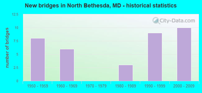
- New bridges - historical statistics
- 81950-1959
- 61960-1969
- 31980-1989
- 91990-1999
- 102000-2009

- Reconstructed bridges - Historical Statistics
- 11980-1989
- 41990-1999
- 22000-2009
- 12010-2019


- Bridge Condition - Deck
- 5.6%Very good
- 77.8%Good
- 16.7%Satisfactory

- Bridge Condition - Superstructure
- 21.1%Very good
- 47.4%Good
- 31.6%Satisfactory

- Bridge Condition - Substructure
- 15.8%Very good
- 31.6%Good
- 52.6%Satisfactory

- Bridge Condition - Channel
- 75.0%Good
- 25.0%Satisfactory
Find on map >> Show street view
Structure Number: 10000015007701, Location: 0.27 MILE NORTH OF I-495 (Lat: 39.022597, Lng: -77.106108), Route carried "on" structure: County highway 326, Year Built: 1958, Year Reconstructed: 2007, Status: Open, Structure Length: 8.38m (27.49ft), Average Daily Traffic: 4,422 (year 2006), Truck Traffic: 5%, Average Future Daily Traffic: 5,099 (year 2026), Design Load: H 20, Features Intersected: IS 270, Facility Carried by Structure: GROSVENOR LANE
Minimum Vertical Clearance: 30+ m (98+ ft), Kilometerpoint: 0.322, Lanes on structure: 2, Lanes under structure: 6, Owner: State Highway Agency, Approaching Roadway Width: 11.6m (38.1ft), Skew: 3 degrees, Material/Design: Steel, Design/Construction: Stringer/Multi-beam, Number Of Spans In Main Unit: 4, Length of Maximum Span: 23.8m (78.1ft), Curb or Sidewalk Widths: Left: 0.9m (3.0ft), Right: 0.9m (3.0ft), Curb-To-Curb Width: 9.1m (29.9ft), Out-to-Out Width: 11.6m (38.1ft)
Condition: Deck: Good, Superstructure: Satisfactory, Substructure: Satisfactory, Operating Rating: 82.1 metric tons, Method Used To Determine Operating Rating: Load Factor (LF), Inventory Rating: 49.0 metric tons, Method Used To Determine Inventory Rating: Load Factor (LF), Structural Evaluation: Equal to present minimum criteria, Deck Geometry: Meets minimum limits, Underclear: Meets minimum limits, Approach Roadway Alignment: Equal to present desirable criteria, Length Of Structure Improvement: 8.38m (27.49ft), Designated Inspection Frequency: Every 24 months, Inspection Date: August 2021, Bridge Improvement Cost: $630,000, Roadway Improvement Cost: $63,000, Total Project Cost: $693,000, Deck Structure Type: Concrete Cast-file-Place, Wearing Surface/Protective System: Wearing Surface: Bituminous
Find on map >> Show street view
Structure Number: 10000015007901, Location: 0.404 M N/DEMOCRACY BLVD (Lat: 39.030283, Lng: -77.126289), Route carried "on" structure: State highway 187, Year Built: 2002, Status: Open, Structure Length: 6.74m (22.11ft), Average Daily Traffic: 45,401 (year 2009), Truck Traffic: 3%, Average Future Daily Traffic: 51,355 (year 2026), Design Load: HS 25 or greater, Features Intersected: IS 270
Minimum Vertical Clearance: 30+ m (98+ ft), Kilometerpoint: 6.056, Lanes on structure: 11, Lanes under structure: 8, Base Highway Network: Yes, Owner: State Highway Agency, Approaching Roadway Width: 44.8m (147.0ft), Skew: 20 degrees, Material/Design: Steel continuous, Design/Construction: Stringer/Multi-beam, Number Of Spans In Main Unit: 2, Length of Maximum Span: 33.5m (109.9ft), Curb or Sidewalk Widths: Left: 1.5m (4.9ft), Right: 1.5m (4.9ft), Curb-To-Curb Width: 39.3m (128.9ft), Out-to-Out Width: 44.6m (146.3ft)
Condition: Deck: Good, Superstructure: Good, Substructure: Good, Operating Rating: 83.0 metric tons, Method Used To Determine Operating Rating: Load Factor (LF), Inventory Rating: 49.4 metric tons, Method Used To Determine Inventory Rating: Load Factor (LF), Structural Evaluation: Better than present minimum criteria, Deck Geometry: Meets minimum limits, Underclear: Meets minimum limits, Approach Roadway Alignment: Equal to present desirable criteria, Designated Inspection Frequency: Every 24 months, Inspection Date: June 2021, Deck Structure Type: Concrete Cast-file-Place, Wearing Surface/Protective System: Wearing Surface: Integral Concrete, Deck Protection: Epoxy Coated Reinforcing
Find on map >> Show street view
Structure Number: 10000015008002, Location: 0.13 MILE N OF IS 270Y (Lat: 39.038806, Lng: -77.145886), Route carried "on" structure: Interstate 270, Year Built: 1958, Year Reconstructed: 1988, Status: Open, Structure Length: 0.64m (2.10ft), Average Daily Traffic: 265,320 (year 2009), Truck Traffic: 8%, Average Future Daily Traffic: 364,620 (year 2029), Design Load: HS 20, Features Intersected: OLD FARM CREEK
Minimum Vertical Clearance: 30+ m (98+ ft), Kilometerpoint: 4.489, Lanes on structure: 12, Base Highway Network: Yes, Owner: State Highway Agency, Approaching Roadway Width: 77.4m (253.9ft), Skew: 21 degrees, Material/Design: Concrete, Design/Construction: Culvert, Length of Maximum Span: 6.1m (20.0ft)
Condition: Channel: Good, Culverts: Satisfactory, Structural Evaluation: Equal to present minimum criteria, Waterway Adequacy: Equal to present desirable criteria, Approach Roadway Alignment: Equal to present desirable criteria, Designated Inspection Frequency: Every 24 months, Inspection Date: September 2020
Find on map >> Show street view
Structure Number: 10000015008101, Location: 0.08 MILE N OF IS 270Y (Lat: 39.037814, Lng: -77.145344), Route carried "on" structure: Interstate 270, Year Built: 1958, Year Reconstructed: 1990, Status: Open, Structure Length: 3.14m (10.30ft), Average Daily Traffic: 265,320 (year 2009), Truck Traffic: 8%, Average Future Daily Traffic: 364,620 (year 2029), Design Load: HS 20+Mod, Features Intersected: TUCKERMAN LANE
Minimum Vertical Clearance: 30+ m (98+ ft), Kilometerpoint: 4.441, Lanes on structure: 12, Lanes under structure: 2, Base Highway Network: Yes, Owner: State Highway Agency, Approaching Roadway Width: 57.9m (190.0ft), Skew: 20 degrees, Material/Design: Steel, Design/Construction: Stringer/Multi-beam, Number Of Spans In Main Unit: 3, Length of Maximum Span: 14.0m (45.9ft), Curb-To-Curb Width: 57.9m (190.0ft), Out-to-Out Width: 58.9m (193.2ft)
Condition: Deck: Good, Superstructure: Good, Substructure: Satisfactory, Inventory Rating: 73.0 metric tons, Method Used To Determine Inventory Rating: Load Factor (LF), Structural Evaluation: Equal to present minimum criteria, Deck Geometry: Superior to present desirable criteria, Underclear: Somewhat better than minimum adequacy, Approach Roadway Alignment: Equal to present desirable criteria, Designated Inspection Frequency: Every 24 months, Inspection Date: April 2020, Deck Structure Type: Concrete Cast-file-Place, Wearing Surface/Protective System: Wearing Surface: Monolithic Concrete, Deck Protection: Epoxy Coated Reinforcing
Find on map >> Show street view
Structure Number: 10000015008201, Location: 0.85 MILE NORTH OF MD 187 (Lat: 39.034119, Lng: -77.142828), Route carried "on" structure: Interstate 270, Year Built: 1958, Year Reconstructed: 1990, Status: Open, Structure Length: 9.11m (29.89ft), Average Daily Traffic: 130,450 (year 2009), Truck Traffic: 8%, Average Future Daily Traffic: 67,976 (year 2026), Design Load: HS 20, Features Intersected: IS 270Y RAMPS B & B3
Minimum Vertical Clearance: 30+ m (98+ ft), Kilometerpoint: 3.846, Lanes on structure: 3, Lanes under structure: 3, Base Highway Network: Yes, Owner: State Highway Agency, Approaching Roadway Width: 17.7m (58.1ft), Skew: 6 degrees, Material/Design: Steel, Design/Construction: Stringer/Multi-beam, Number Of Spans In Main Unit: 1, Number Of Approach Spans: 2, Length of Maximum Span: 36.6m (120.1ft), Curb-To-Curb Width: 17.7m (58.1ft), Out-to-Out Width: 18.8m (61.7ft)
Condition: Deck: Satisfactory, Superstructure: Satisfactory, Substructure: Satisfactory, Operating Rating: 71.2 metric tons, Method Used To Determine Operating Rating: Load Factor (LF), Inventory Rating: 42.6 metric tons, Method Used To Determine Inventory Rating: Load Factor (LF), Structural Evaluation: Equal to present minimum criteria, Deck Geometry: Better than present minimum criteria, Underclear: High priority of corrective action, Approach Roadway Alignment: Equal to present minimum criteria, Designated Inspection Frequency: Every 24 months, Inspection Date: September 2021, Deck Structure Type: Concrete Cast-file-Place, Wearing Surface/Protective System: Wearing Surface: Monolithic Concrete, Deck Protection: Epoxy Coated Reinforcing
Find on map >> Show street view
Structure Number: 10000015009701, Location: @ IS 270Y (Lat: 39.021742, Lng: -77.142347), Route carried "on" structure: County highway 166, Year Built: 2004, Status: Open, Structure Length: 7.50m (24.61ft), Average Daily Traffic: 25,601 (year 2018), Truck Traffic: 5%, Average Future Daily Traffic: 25,624 (year 2038), Design Load: HS 25 or greater, Features Intersected: IS 270Y, Facility Carried by Structure: DEMOCRACY BLVD
Minimum Vertical Clearance: 30+ m (98+ ft), Kilometerpoint: 1.577, Lanes on structure: 8, Lanes under structure: 6, Owner: State Highway Agency, Approaching Roadway Width: 31.7m (104.0ft), Skew: 22 degrees, Material/Design: Steel, Design/Construction: Stringer/Multi-beam, Number Of Spans In Main Unit: 2, Length of Maximum Span: 37.2m (122.0ft), Curb or Sidewalk Widths: Left: 3.0m (9.8ft), Right: 1.6m (5.2ft), Curb-To-Curb Width: 30.5m (100.1ft), Out-to-Out Width: 37.2m (122.0ft)
Condition: Deck: Good, Superstructure: Good, Substructure: Good, Operating Rating: 71.7 metric tons, Method Used To Determine Operating Rating: Load Factor (LF), Inventory Rating: 64.4 metric tons, Method Used To Determine Inventory Rating: Load Factor (LF), Structural Evaluation: Better than present minimum criteria, Deck Geometry: Somewhat better than minimum adequacy, Underclear: Meets minimum limits, Approach Roadway Alignment: Equal to present desirable criteria, Designated Inspection Frequency: Every 24 months, Inspection Date: November 2021, Deck Structure Type: Concrete Cast-file-Place, Wearing Surface/Protective System: Wearing Surface: Integral Concrete, Deck Protection: Epoxy Coated Reinforcing
Find on map >> Show street view
Structure Number: 10000015011201, Location: 0.26 MILE EAST OF MD 191 (Lat: 39.012983, Lng: -77.149228), Route carried "on" structure: Interstate 495, Year Built: 1996, Status: Open, Structure Length: 9.33m (30.61ft), Average Daily Traffic: 115,850 (year 2009), Truck Traffic: 8%, Average Future Daily Traffic: 132,850 (year 2029), Design Load: HS 25 or greater, Features Intersected: IS 270Y
Minimum Vertical Clearance: 30+ m (98+ ft), Kilometerpoint: 6.356, Lanes on structure: 3, Lanes under structure: 2, Base Highway Network: Yes, Owner: State Highway Agency, Approaching Roadway Width: 17.1m (56.1ft), Skew: 3 degrees, Material/Design: Steel continuous, Design/Construction: Stringer/Multi-beam, Number Of Spans In Main Unit: 2, Length of Maximum Span: 48.2m (158.1ft), Curb or Sidewalk Widths: Left: 0.6m (2.0ft), Right: 0.6m (2.0ft), Curb-To-Curb Width: 17.7m (58.1ft), Out-to-Out Width: 18.9m (62.0ft)
Condition: Deck: Satisfactory, Superstructure: Good, Substructure: Good, Inventory Rating: 69.8 metric tons, Method Used To Determine Inventory Rating: Load Factor (LF), Structural Evaluation: Better than present minimum criteria, Deck Geometry: Better than present minimum criteria, Underclear: Equal to present desirable criteria, Approach Roadway Alignment: Equal to present minimum criteria, Designated Inspection Frequency: Every 24 months, Inspection Date: March 2020, Deck Structure Type: Concrete Cast-file-Place, Wearing Surface/Protective System: Wearing Surface: Monolithic Concrete, Membrane: Built-up, Deck Protection: Epoxy Coated Reinforcing
Find on map >> Show street view
Structure Number: 10000015011701, Location: 0.1 MILE N OF IS 495 WBL (Lat: 39.019792, Lng: -77.102947), Route carried "on" structure: State highway 355, Year Built: 1960, Year Reconstructed: 1998, Status: Open, Structure Length: 4.24m (13.91ft), Average Daily Traffic: 55,020 (year 2009), Truck Traffic: 8%, Average Future Daily Traffic: 33,587 (year 2026), Design Load: HS 20, Features Intersected: MD 355 RAMP 1
Minimum Vertical Clearance: 30+ m (98+ ft), Kilometerpoint: 6.645, Lanes on structure: 3, Lanes under structure: 1, Base Highway Network: Yes, Owner: State Highway Agency, Approaching Roadway Width: 11.0m (36.1ft), Skew: 3 degrees, Material/Design: Steel continuous, Design/Construction: Stringer/Multi-beam, Number Of Spans In Main Unit: 3, Length of Maximum Span: 15.2m (49.9ft), Curb-To-Curb Width: 11.0m (36.1ft), Out-to-Out Width: 12.7m (41.7ft)
Condition: Deck: Good, Superstructure: Satisfactory, Substructure: Satisfactory, Operating Rating: 60.3 metric tons, Method Used To Determine Operating Rating: Load Factor (LF), Inventory Rating: 36.3 metric tons, Method Used To Determine Inventory Rating: Load Factor (LF), Structural Evaluation: Equal to present minimum criteria, Deck Geometry: High priority of replacement, Underclear: High priority of corrective action, Approach Roadway Alignment: Equal to present desirable criteria, Length Of Structure Improvement: 4.24m (13.91ft), Designated Inspection Frequency: Every 24 months, Inspection Date: November 2020, Bridge Improvement Cost: $348,000, Roadway Improvement Cost: $35,000, Total Project Cost: $383,000, Deck Structure Type: Concrete Cast-file-Place, Wearing Surface/Protective System: Wearing Surface: Bituminous
Find on map >> Show street view
Structure Number: 10000015011801, Location: 0.07 MILE NORTH OF IS 495 (Lat: 39.019100, Lng: -77.102853), Route carried "on" structure: State highway 355, Year Built: 1960, Status: Open, Structure Length: 9.94m (32.61ft), Average Daily Traffic: 55,020 (year 2009), Truck Traffic: 8%, Average Future Daily Traffic: 33,587 (year 2026), Design Load: HS 20, Features Intersected: IS 495 OL
Minimum Vertical Clearance: 30+ m (98+ ft), Kilometerpoint: 6.484, Lanes on structure: 4, Lanes under structure: 5, Base Highway Network: Yes, Owner: State Highway Agency, Approaching Roadway Width: 17.1m (56.1ft), Skew: 5 degrees, Material/Design: Steel continuous, Design/Construction: Stringer/Multi-beam, Number Of Spans In Main Unit: 2, Number Of Approach Spans: 2, Length of Maximum Span: 36.3m (119.1ft), Curb-To-Curb Width: 17.1m (56.1ft), Out-to-Out Width: 18.8m (61.7ft)
Condition: Deck: Good, Superstructure: Satisfactory, Substructure: Satisfactory, Operating Rating: 49.4 metric tons, Method Used To Determine Operating Rating: Load Factor (LF), Inventory Rating: 29.5 metric tons, Method Used To Determine Inventory Rating: Load Factor (LF), Structural Evaluation: Equal to present minimum criteria, Deck Geometry: Somewhat better than minimum adequacy, Underclear: High priority of corrective action, Approach Roadway Alignment: Equal to present desirable criteria, Length Of Structure Improvement: 9.94m (32.61ft), Designated Inspection Frequency: Every 24 months, Inspection Date: March 2021, Bridge Improvement Cost: $1,207,000, Roadway Improvement Cost: $121,000, Total Project Cost: $1,328,000, Deck Structure Type: Concrete Cast-file-Place, Wearing Surface/Protective System: Wearing Surface: Bituminous
Find on map >> Show street view
Structure Number: 10000015011901, Location: 0.07 MILE NORTH OF IS 495 (Lat: 39.017250, Lng: -77.100753), Route carried "on" structure: State highway 355, Year Built: 1958, Year Reconstructed: 2008, Status: Open, Structure Length: 8.05m (26.41ft), Average Daily Traffic: 55,020 (year 2009), Truck Traffic: 8%, Average Future Daily Traffic: 33,587 (year 2026), Design Load: HS 20, Features Intersected: IS 495 OL
Minimum Vertical Clearance: 30+ m (98+ ft), Kilometerpoint: 6.484, Lanes on structure: 3, Lanes under structure: 4, Base Highway Network: Yes, Owner: State Highway Agency, Approaching Roadway Width: 11.0m (36.1ft), Skew: 5 degrees, Material/Design: Steel, Design/Construction: Stringer/Multi-beam, Number Of Spans In Main Unit: 3, Length of Maximum Span: 37.2m (122.0ft), Curb or Sidewalk Widths: Left: 0.0m, Right: 1.6m (5.2ft), Curb-To-Curb Width: 11.2m (36.7ft), Out-to-Out Width: 13.6m (44.6ft)
Condition: Deck: Good, Superstructure: Good, Substructure: Good, Operating Rating: 57.1 metric tons, Method Used To Determine Operating Rating: Load Factor (LF), Inventory Rating: 34.0 metric tons, Method Used To Determine Inventory Rating: Load Factor (LF), Structural Evaluation: Better than present minimum criteria, Deck Geometry: High priority of replacement, Underclear: High priority of replacement, Approach Roadway Alignment: Equal to present desirable criteria, Length Of Structure Improvement: 8.05m (26.41ft), Designated Inspection Frequency: Every 24 months, Inspection Date: March 2021, Bridge Improvement Cost: $1,416,000, Roadway Improvement Cost: $142,000, Total Project Cost: $1,558,000, Deck Structure Type: Concrete Cast-file-Place, Wearing Surface/Protective System: Wearing Surface: Bituminous
Find on map >> Show street view
Structure Number: 10000015014501, Location: 1.04 MILE SOUTH OF MD 187 (Lat: 39.019914, Lng: -77.105442), Route carried "on" structure: Interstate 270, Year Built: 1990, Status: Open, Structure Length: 3.60m (11.81ft), Average Daily Traffic: 44,696 (year 2017), Truck Traffic: 8%, Average Future Daily Traffic: 66,416 (year 2037), Design Load: HS 20+Mod, Features Intersected: IS 495 OL
Minimum Vertical Clearance: 4.88m (16.01ft), Kilometerpoint: 0.080, Lanes on structure: 2, Lanes under structure: 4, Base Highway Network: Yes, Owner: State Highway Agency, Approaching Roadway Width: 12.2m (40.0ft), Skew: 2 degrees, Material/Design: Steel, Design/Construction: Stringer/Multi-beam, Number Of Spans In Main Unit: 1, Length of Maximum Span: 34.4m (112.9ft), Curb-To-Curb Width: 12.2m (40.0ft), Out-to-Out Width: 13.2m (43.3ft)
Condition: Deck: Good, Superstructure: Good, Substructure: Satisfactory, Inventory Rating: 57.6 metric tons, Method Used To Determine Inventory Rating: Load Factor (LF), Structural Evaluation: Equal to present minimum criteria, Deck Geometry: Better than present minimum criteria, Underclear: Somewhat better than minimum adequacy, Approach Roadway Alignment: Equal to present desirable criteria, Designated Inspection Frequency: Every 24 months, Inspection Date: August 2020, Deck Structure Type: Concrete Cast-file-Place, Wearing Surface/Protective System: Wearing Surface: Monolithic Concrete, Deck Protection: Epoxy Coated Reinforcing
Find on map >> Show street view
Structure Number: 10000015016201, Location: 1.19 MILE SOUTH OF MD 187 (Lat: 39.019564, Lng: -77.104794), Route carried "on" structure: Ramp Interstate 270, Year Built: 1990, Status: Open, Structure Length: 4.15m (13.62ft), Average Daily Traffic: 11,255 (year 2017), Truck Traffic: 8%, Average Future Daily Traffic: 16,725 (year 2037), Design Load: HS 20+Mod, Features Intersected: IS 495 OL
Minimum Vertical Clearance: 30+ m (98+ ft), Kilometerpoint: 0.209, Lanes on structure: 1, Lanes under structure: 4, Base Highway Network: Yes, Owner: State Highway Agency, Approaching Roadway Width: 9.4m (30.8ft), Skew: 3 degrees, Material/Design: Steel, Design/Construction: Stringer/Multi-beam, Number Of Spans In Main Unit: 1, Length of Maximum Span: 39.3m (128.9ft), Curb-To-Curb Width: 9.4m (30.8ft), Out-to-Out Width: 10.4m (34.1ft)
Condition: Deck: Good, Superstructure: Good, Substructure: Satisfactory, Operating Rating: 90.2 metric tons, Method Used To Determine Operating Rating: Load Factor (LF), Inventory Rating: 73.5 metric tons, Method Used To Determine Inventory Rating: Load Factor (LF), Structural Evaluation: Equal to present minimum criteria, Deck Geometry: Superior to present desirable criteria, Underclear: Equal to present minimum criteria, Approach Roadway Alignment: Equal to present desirable criteria, Designated Inspection Frequency: Every 24 months, Inspection Date: August 2020, Deck Structure Type: Concrete Cast-file-Place, Wearing Surface/Protective System: Wearing Surface: Monolithic Concrete, Deck Protection: Epoxy Coated Reinforcing
Find on map >> Show street view
Structure Number: 10000015016801, Location: 0.29 MILE NORTH OF MD 187 (Lat: 39.031350, Lng: -77.131589), Route carried "on" structure: State highway 187B, Year Built: 2002, Status: Open, Structure Length: 5.30m (17.39ft), Average Daily Traffic: 19,205 (year 2008), Average Future Daily Traffic: 22,143 (year 2026), Design Load: HS 25 or greater, Features Intersected: 1S 270
Minimum Vertical Clearance: 30+ m (98+ ft), Kilometerpoint: 0.224, Lanes on structure: 5, Lanes under structure: 6, Owner: State Highway Agency, Approaching Roadway Width: 32.3m (106.0ft), Skew: 30 degrees, Material/Design: Steel continuous, Design/Construction: Stringer/Multi-beam, Number Of Spans In Main Unit: 2, Length of Maximum Span: 26.2m (86.0ft), Curb or Sidewalk Widths: Left: 3.0m (9.8ft), Right: 0.0m, Curb-To-Curb Width: 20.1m (65.9ft), Out-to-Out Width: 25.5m (83.7ft)
Condition: Deck: Good, Superstructure: Good, Substructure: Good, Inventory Rating: 60.8 metric tons, Method Used To Determine Inventory Rating: Load Factor (LF), Structural Evaluation: Better than present minimum criteria, Deck Geometry: Somewhat better than minimum adequacy, Underclear: Equal to present minimum criteria, Approach Roadway Alignment: Equal to present desirable criteria, Designated Inspection Frequency: Every 24 months, Inspection Date: June 2021, Deck Structure Type: Concrete Cast-file-Place, Wearing Surface/Protective System: Wearing Surface: Integral Concrete, Deck Protection: Epoxy Coated Reinforcing
Find on map >> Show street view
Structure Number: 10000015017004, Location: 0.13 M E OF BR NO 1506800 (Lat: 39.055947, Lng: -77.152189), Route carried "on" structure: State highway 927, Year Built: 1988, Status: Open, Structure Length: 1.13m (3.71ft), Average Daily Traffic: 57,252 (year 2009), Truck Traffic: 8%, Average Future Daily Traffic: 61,812 (year 2029), Design Load: HS 20, Features Intersected: IS 270 RAMP 'I'
Minimum Vertical Clearance: 5.18m (16.99ft), Kilometerpoint: 2.430, Lanes on structure: 5, Lanes under structure: 1, Base Highway Network: Yes, Owner: State Highway Agency, Approaching Roadway Width: 37.8m (124.0ft), Skew: 20 degrees, Material/Design: Concrete, Design/Construction: Frame, Number Of Spans In Main Unit: 1, Length of Maximum Span: 11.3m (37.1ft), Curb-To-Curb Width: 32.9m (107.9ft), Out-to-Out Width: 38.1m (125.0ft)
Condition: Deck: Satisfactory, Superstructure: Satisfactory, Substructure: Satisfactory, Operating Rating: 44.4 metric tons, Method Used To Determine Operating Rating: Allowable Stress (AS), Inventory Rating: 32.7 metric tons, Method Used To Determine Inventory Rating: Allowable Stress (AS), Structural Evaluation: Equal to present minimum criteria, Deck Geometry: Superior to present desirable criteria, Underclear: Superior to present desirable criteria, Approach Roadway Alignment: Equal to present desirable criteria, Designated Inspection Frequency: Every 24 months, Inspection Date: September 2020, Deck Structure Type: Concrete Cast-file-Place, Wearing Surface/Protective System: Wearing Surface: Monolithic Concrete, Deck Protection: Epoxy Coated Reinforcing
Find on map >> Show street view
Structure Number: 10000015018201, Location: AT WESTLAKE TERRACE (Lat: 39.022325, Lng: -77.140294), Route carried "on" structure: Interstate 270Y, Year Built: 2004, Status: Open, Structure Length: 15.39m (50.49ft), Average Daily Traffic: 114,000 (year 2000), Truck Traffic: 6%, Average Future Daily Traffic: 177,000 (year 2020), Design Load: HS 25 or greater, Features Intersected: IS 270Y MEDIAN
Minimum Vertical Clearance: 30+ m (98+ ft), Kilometerpoint: 1.915, Lanes on structure: 2, Base Highway Network: Yes, Owner: State Highway Agency, Approaching Roadway Width: 12.8m (42.0ft), Skew: 30 degrees, Material/Design: Steel, Design/Construction: Girder and Floorbeam System, Number Of Spans In Main Unit: 6, Length of Maximum Span: 27.4m (89.9ft), Curb-To-Curb Width: 12.2m (40.0ft), Out-to-Out Width: 14.0m (45.9ft)
Condition: Deck: Good, Superstructure: Very good, Substructure: Very good, Operating Rating: 79.8 metric tons, Method Used To Determine Operating Rating: Load Factor (LF), Inventory Rating: 47.6 metric tons, Method Used To Determine Inventory Rating: Load Factor (LF), Structural Evaluation: Equal to present desirable criteria, Deck Geometry: Somewhat better than minimum adequacy, Approach Roadway Alignment: Equal to present desirable criteria, Designated Inspection Frequency: Every 24 months, Critical Feature Inspection Frequency: Every 24 months, Other Special Inspection Frequency: Every 12 months, Inspection Date: October 2021, Critical Feature Inspection Date: October 2021, Other Special Inspection Date: October 2021, Deck Structure Type: Concrete Cast-file-Place, Wearing Surface/Protective System: Wearing Surface: Integral Concrete, Deck Protection: Epoxy Coated Reinforcing
Find on map >> Show street view
Structure Number: 10000015019401, Location: 2.5 MI N. OF I-495 (Lat: 39.052406, Lng: -77.116008), Route carried "on" structure: State highway 355, Year Built: 2009, Status: Open, Structure Length: 5.49m (18.01ft), Average Daily Traffic: 60,000 (year 2007), Truck Traffic: 4%, Average Future Daily Traffic: 98,100 (year 2030), Features Intersected: RELOCATED RANDOLPH ROAD
Minimum Vertical Clearance: 30+ m (98+ ft), Kilometerpoint: 10.603, Lanes on structure: 7, Lanes under structure: 6, Base Highway Network: Yes, Owner: State Highway Agency, Approaching Roadway Width: 35.1m (115.2ft), Skew: 20 degrees, Material/Design: Steel continuous, Design/Construction: Stringer/Multi-beam, Number Of Spans In Main Unit: 2, Length of Maximum Span: 28.3m (92.8ft), Curb or Sidewalk Widths: Left: 0.0m, Right: 2.0m (6.6ft), Curb-To-Curb Width: 27.3m (89.6ft), Out-to-Out Width: 35.2m (115.5ft)
Condition: Deck: Good, Superstructure: Very good, Substructure: Very good, Operating Rating: 96.6 metric tons, Method Used To Determine Operating Rating: Load and Resistance Factor Rating (LRFR) rating reported by rating factor(RF) method using HL-93 loadings, Inventory Rating: 74.5 metric tons, Method Used To Determine Inventory Rating: Load and Resistance Factor Rating (LRFR) rating reported by rating factor(RF) method using HL-93 loadings, Structural Evaluation: Equal to present desirable criteria, Deck Geometry: Somewhat better than minimum adequacy, Underclear: Superior to present desirable criteria, Approach Roadway Alignment: Equal to present desirable criteria, Designated Inspection Frequency: Every 24 months, Inspection Date: September 2021, Deck Structure Type: Concrete Cast-file-Place, Wearing Surface/Protective System: Wearing Surface: Monolithic Concrete, Deck Protection: Epoxy Coated Reinforcing
Find on map >> Show street view
Structure Number: 200000M-011101, Location: 40 FT E OF FALLEN OAK RD (Lat: 38.999358, Lng: -77.129728), Route carried "on" structure: County highway 1536, Year Built: 1964, Year Reconstructed: 2015, Status: Open, Structure Length: 0.98m (3.22ft), Average Daily Traffic: 211 (year 2018), Truck Traffic: 1%, Average Future Daily Traffic: 345 (year 2040), Features Intersected: BOOZE CREEK, Facility Carried by Structure: VALLEY ROAD
Minimum Vertical Clearance: 30+ m (98+ ft), Kilometerpoint: 0.531, Lanes on structure: 2, Owner: County Highway Agency, Approaching Roadway Width: 7.9m (25.9ft), Material/Design: Prestressed concrete, Design/Construction: Slab, Number Of Spans In Main Unit: 1, Length of Maximum Span: 8.8m (28.9ft), Curb or Sidewalk Widths: Left: 1.5m (4.9ft), Right: 1.5m (4.9ft), Curb-To-Curb Width: 7.9m (25.9ft), Out-to-Out Width: 11.9m (39.0ft)
Condition: Deck: Very good, Superstructure: Very good, Substructure: Very good, Channel: Good, Operating Rating: 89.7 metric tons, Method Used To Determine Operating Rating: Load and Resistance Factor Rating (LRFR) rating reported by rating factor(RF) method using HL-93 loadings, Inventory Rating: 67.4 metric tons, Method Used To Determine Inventory Rating: Load and Resistance Factor Rating (LRFR) rating reported by rating factor(RF) method using HL-93 loadings, Structural Evaluation: Equal to present desirable criteria, Deck Geometry: Somewhat better than minimum adequacy, Waterway Adequacy: Better than present minimum criteria, Approach Roadway Alignment: Equal to present desirable criteria, Designated Inspection Frequency: Every 24 months, Inspection Date: Febuary 2020, Deck Structure Type: Concrete Cast-file-Place, Wearing Surface/Protective System: Wearing Surface: Integral Concrete
Find on map >> Show street view
Structure Number: 200000M-011201, Location: 0.5 MILES SOUTH OF MD 191 (Lat: 38.997008, Lng: -77.139178), Route carried "on" structure: County highway 836, Year Built: 2008, Status: Open, Structure Length: 1.22m (4.00ft), Average Daily Traffic: 1,938 (year 2021), Truck Traffic: 3%, Average Future Daily Traffic: 2,152 (year 2041), Design Load: HS 25 or greater, Features Intersected: BOOZE CREEK, Facility Carried by Structure: BURNING TREE ROAD
Minimum Vertical Clearance: 30+ m (98+ ft), Kilometerpoint: 0.483, Lanes on structure: 2, Owner: County Highway Agency, Approaching Roadway Width: 6.1m (20.0ft), Material/Design: Prestressed concrete, Design/Construction: Slab, Number Of Spans In Main Unit: 1, Length of Maximum Span: 11.3m (37.1ft), Curb or Sidewalk Widths: Left: 1.6m (5.2ft), Right: 1.6m (5.2ft), Curb-To-Curb Width: 8.8m (28.9ft), Out-to-Out Width: 12.8m (42.0ft)
Condition: Deck: Good, Superstructure: Very good, Substructure: Good, Channel: Good, Inventory Rating: 57.6 metric tons, Method Used To Determine Inventory Rating: Load Factor (LF), Structural Evaluation: Better than present minimum criteria, Deck Geometry: Somewhat better than minimum adequacy, Waterway Adequacy: Better than present minimum criteria, Approach Roadway Alignment: Equal to present desirable criteria, Designated Inspection Frequency: Every 24 months, Inspection Date: July 2021, Deck Structure Type: Concrete Precast Panels, Wearing Surface/Protective System: Wearing Surface: Integral Concrete, Deck Protection: Epoxy Coated Reinforcing
Find on map >> Show street view
Structure Number: 200000M-024701, Location: 1 MI N OF DEMOCRACY BLVD (Lat: 39.026339, Lng: -77.142458), Route carried "on" structure: County highway 3438, Year Built: 1994, Year Reconstructed: 2004, Status: Open, Structure Length: 11.13m (36.52ft), Average Daily Traffic: 17,489 (year 2021), Truck Traffic: 5%, Average Future Daily Traffic: 21,267 (year 2041), Design Load: HS 25 or greater, Features Intersected: I-270, Facility Carried by Structure: WESTLAKE TERRACE-F
Minimum Vertical Clearance: 30+ m (98+ ft), Kilometerpoint: 0.000, Lanes on structure: 5, Lanes under structure: 8, Owner: County Highway Agency, Approaching Roadway Width: 20.4m (66.9ft), Skew: 20 degrees, Material/Design: Steel continuous, Design/Construction: Stringer/Multi-beam, Number Of Spans In Main Unit: 3, Length of Maximum Span: 43.6m (143.0ft), Curb or Sidewalk Widths: Left: 1.8m (5.9ft), Right: 1.8m (5.9ft), Curb-To-Curb Width: 19.8m (65.0ft), Out-to-Out Width: 24.8m (81.4ft)
Condition: Deck: Good, Superstructure: Good, Substructure: Satisfactory, Operating Rating: 76.2 metric tons, Method Used To Determine Operating Rating: Load Factor (LF), Inventory Rating: 45.8 metric tons, Method Used To Determine Inventory Rating: Load Factor (LF), Structural Evaluation: Equal to present minimum criteria, Deck Geometry: Meets minimum limits, Underclear: Superior to present desirable criteria, Approach Roadway Alignment: Equal to present minimum criteria, Designated Inspection Frequency: Every 24 months, Inspection Date: August 2021, Deck Structure Type: Concrete Cast-file-Place, Wearing Surface/Protective System: Wearing Surface: Integral Concrete, Deck Protection: Epoxy Coated Reinforcing
Find on map >> Show street view
Structure Number: 200000M-043501, Location: 900 FT. W. OF MD 191 (Lat: 38.997022, Lng: -77.133283), Route carried "on" structure: County highway 2319, Year Built: 1980, Status: Open, Structure Length: 0.88m (2.89ft), Average Daily Traffic: 100 (year 2018), Truck Traffic: 1%, Average Future Daily Traffic: 125 (year 2040), Features Intersected: BOOZE CREEK TRIB, Facility Carried by Structure: HOWELL ROAD
Minimum Vertical Clearance: 30+ m (98+ ft), Kilometerpoint: 0.000, Lanes on structure: 2, Owner: County Highway Agency, Approaching Roadway Width: 7.9m (25.9ft), Material/Design: Steel, Design/Construction: Arch - Deck, Length of Maximum Span: 4.3m (14.1ft), Curb-To-Curb Width: 7.9m (25.9ft), Out-to-Out Width: 7.9m (25.9ft)
Condition: Superstructure: Satisfactory, Substructure: Satisfactory, Channel: Satisfactory, Structural Evaluation: Equal to present minimum criteria, Deck Geometry: Equal to present minimum criteria, Waterway Adequacy: Equal to present desirable criteria, Approach Roadway Alignment: Equal to present desirable criteria, Designated Inspection Frequency: Every 24 months, Inspection Date: January 2020
Find on map >> Show street view
Structure Number: 10000015007701, Location: 0.27 MILE NORTH OF IS 695 (Lat: 39.022597, Lng: -77.106108), Route carried "under" structure: Interstate 270, Year Built: 1958, Structure Length: 0. m, Average Daily Traffic: 122,760 (year 2009), Features Intersected: IS 270, Facility Carried by Structure: GROSVENOR LA
Minimum Vertical Clearance: 4.57m (14.99ft), Kilometerpoint: 0.434, Lanes on structure: 2, Lanes under structure: 4, Material/Design: Steel, Design/Construction: Stringer/Multi-beam, Length of Maximum Span: 23.8m (78.1ft)
Find on map >> Show street view
Structure Number: 10000015007901, Location: 1027 M N OF BR NO 1507700 (Lat: 39.030283, Lng: -77.126289), Route carried "under" structure: Interstate 270, Year Built: 2002, Structure Length: 0. m, Average Daily Traffic: 130,450 (year 2009), Features Intersected: IS 270, Facility Carried by Structure: MD 187
Minimum Vertical Clearance: 4.88m (16.01ft), Kilometerpoint: 2.478, Lanes on structure: 11, Lanes under structure: 8, Material/Design: Steel continuous, Design/Construction: Stringer/Multi-beam, Length of Maximum Span: 33.5m (109.9ft)
Find on map >> Show street view
Structure Number: 10000015008101, Location: 0.25 MI W OF IS 270Y (Lat: 39.037814, Lng: -77.145344), Route carried "under" structure: County highway 164, Year Built: 1958, Structure Length: 0. m, Average Daily Traffic: 21,000 (year 2006), Features Intersected: TUCKERMAN LANE, Facility Carried by Structure: IS 270
Minimum Vertical Clearance: 4.27m (14.01ft), Kilometerpoint: 1.850, Lanes on structure: 12, Lanes under structure: 2, Material/Design: Steel, Design/Construction: Stringer/Multi-beam, Length of Maximum Span: 14.0m (45.9ft)
Find on map >> Show street view
Structure Number: 10000015008201, Location: .91 M N OF DEMOCRACY BLVD (Lat: 39.034119, Lng: -77.142828), Route carried "under" structure: Interstate 270Y, Year Built: 1958, Structure Length: 0. m, Average Daily Traffic: 132,561 (year 2009), Features Intersected: IS 270Y RAMPS 'B' & 'B3', Facility Carried by Structure: IS 270 RAMP 'C'
Minimum Vertical Clearance: 5.18m (16.99ft), Kilometerpoint: 2.590, Lanes on structure: 3, Lanes under structure: 3, Material/Design: Steel, Design/Construction: Stringer/Multi-beam, Length of Maximum Span: 36.6m (120.1ft)
Find on map >> Show street view
Structure Number: 10000015009701, Location: 0.79 MILE NORTH OF IS 495 (Lat: 39.021742, Lng: -77.142347), Route carried "under" structure: Interstate 270Y, Year Built: 2004, Structure Length: 0. m, Average Daily Traffic: 132,561 (year 2009), Truck Traffic: 8%, Features Intersected: IS 270Y, Facility Carried by Structure: DEMOCRACY BLVD
Minimum Vertical Clearance: 4.88m (16.01ft), Kilometerpoint: 1.271, Lanes on structure: 8, Lanes under structure: 6, Material/Design: Steel, Design/Construction: Stringer/Multi-beam, Length of Maximum Span: 37.2m (122.0ft)
Find on map >> Show street view
Structure Number: 10000015011201, Location: 0.05 MILE NORTH OF IS 495 (Lat: 39.012983, Lng: -77.149228), Route carried "under" structure: Interstate 270Y, Year Built: 1996, Structure Length: 0. m, Average Daily Traffic: 129,011 (year 2009), Features Intersected: IS 270Y, Facility Carried by Structure: IS 495 OL
Minimum Vertical Clearance: 5.18m (16.99ft), Kilometerpoint: 0.080, Lanes on structure: 3, Lanes under structure: 2, Material/Design: Steel continuous, Design/Construction: Stringer/Multi-beam, Length of Maximum Span: 30.5m (100.1ft)
Find on map >> Show street view
Structure Number: 10000015011701, Location: 0.10 MI N OF IS 495 (Lat: 39.019792, Lng: -77.102947), Route carried "under" structure: Interstate 270, Year Built: 1960, Structure Length: 0. m, Average Daily Traffic: 10,596 (year 2007), Truck Traffic: 8%, Features Intersected: MD 355 RAMP 1, Facility Carried by Structure: MD 355 SBR
Minimum Vertical Clearance: 5.49m (18.01ft), Kilometerpoint: 0.161, Lanes on structure: 3, Lanes under structure: 2, Material/Design: Steel continuous, Design/Construction: Stringer/Multi-beam, Length of Maximum Span: 15.2m (49.9ft)
Find on map >> Show street view
Structure Number: 10000015011801, Location: 1.02 MILES EAST OF MD 187 (Lat: 39.019100, Lng: -77.102853), Route carried "under" structure: Interstate 495, Year Built: 1960, Structure Length: 0. m, Average Daily Traffic: 115,750 (year 2009), Features Intersected: IS 495 OL, Facility Carried by Structure: MD 355 SBR
Minimum Vertical Clearance: 4.88m (16.01ft), Kilometerpoint: 10.668, Lanes on structure: 4, Lanes under structure: 5, Material/Design: Steel continuous, Design/Construction: Stringer/Multi-beam, Length of Maximum Span: 36.3m (119.1ft)
Find on map >> Show street view
Structure Number: 10000015011901, Location: 1.1 MILES EAST OF MD 187 (Lat: 39.017250, Lng: -77.100753), Route carried "under" structure: Interstate 495, Year Built: 1960, Structure Length: 0. m, Average Daily Traffic: 238,050 (year 2009), Features Intersected: IS 495 OL, Facility Carried by Structure: MD 355 NBR
Minimum Vertical Clearance: 5.49m (18.01ft), Kilometerpoint: 10.796, Lanes on structure: 3, Lanes under structure: 4, Material/Design: Steel, Design/Construction: Stringer/Multi-beam, Length of Maximum Span: 37.2m (122.0ft)
Find on map >> Show street view
Structure Number: 10000015014501, Location: 0.15 MILE WEST OF IS 270 (Lat: 39.019914, Lng: -77.105442), Route carried "under" structure: Interstate 495, Year Built: 1990, Structure Length: 0. m, Average Daily Traffic: 115,750 (year 2009), Truck Traffic: 8%, Features Intersected: IS 495 OL, Facility Carried by Structure: IS 270 SBR
Minimum Vertical Clearance: 4.88m (16.01ft), Kilometerpoint: 10.249, Lanes on structure: 2, Lanes under structure: 4, Material/Design: Steel, Design/Construction: Stringer/Multi-beam, Length of Maximum Span: 34.4m (112.9ft)
Find on map >> Show street view
Structure Number: 10000015016201, Location: 0.78 MILE EAST OF MD 187 (Lat: 39.019564, Lng: -77.104794), Route carried "under" structure: Interstate 495, Year Built: 1990, Structure Length: 0. m, Average Daily Traffic: 115,750 (year 2009), Truck Traffic: 8%, Features Intersected: IS 495 OL, Facility Carried by Structure: IS 270 RAMP 'A'(6)
Minimum Vertical Clearance: 5.49m (18.01ft), Kilometerpoint: 10.282, Lanes on structure: 1, Lanes under structure: 4, Material/Design: Steel, Design/Construction: Stringer/Multi-beam, Length of Maximum Span: 39.3m (128.9ft)
Find on map >> Show street view
Structure Number: 10000015016801, Location: 0.29 MILE NORTH OF MD 187 (Lat: 39.031350, Lng: -77.131589), Route carried "under" structure: Interstate 270, Year Built: 2002, Structure Length: 0. m, Average Daily Traffic: 130,450 (year 2009), Truck Traffic: 6%, Features Intersected: IS 270, Facility Carried by Structure: ROCKLEDGE BL'VD
Minimum Vertical Clearance: 4.88m (16.01ft), Kilometerpoint: 2.944, Lanes on structure: 5, Lanes under structure: 6, Material/Design: Steel continuous, Design/Construction: Stringer/Multi-beam, Length of Maximum Span: 26.2m (86.0ft)
Find on map >> Show street view
Structure Number: 10000015017001, Location: 0.13 MILE EAST OF IS 270 (Lat: 39.055947, Lng: -77.152189), Route carried "under" structure: Ramp Interstate 270, Year Built: 1988, Structure Length: 0. m, Average Daily Traffic: 1,487 (year 2006), Truck Traffic: 8%, Features Intersected: IS 270 RAMP 'I', Facility Carried by Structure: MD 927 & RAMP 'D'
Minimum Vertical Clearance: 5.18m (16.99ft), Kilometerpoint: 6.661, Lanes on structure: 5, Lanes under structure: 1, Material/Design: Concrete, Design/Construction: Frame, Length of Maximum Span: 11.3m (37.1ft)
Find on map >> Show street view
Structure Number: 10000015017101, Location: 0.87 M N/DEMOCRACY BL'VD (Lat: 39.033367, Lng: -77.142581), Route carried "under" structure: Interstate 270Y, Year Built: 1995, Structure Length: 0. m, Average Daily Traffic: 132,561 (year 2009), Truck Traffic: 8%, Features Intersected: IS 270Y, Facility Carried by Structure: IS 270 RAMP A 1
Minimum Vertical Clearance: 7.62m (25.00ft), Kilometerpoint: 2.671, Lanes on structure: 1, Lanes under structure: 3, Material/Design: Steel continuous, Design/Construction: Stringer/Multi-beam, Length of Maximum Span: 76.2m (250.0ft)
Find on map >> Show street view
Structure Number: 200000M-024701, Location: 1 MI N OF DEMOCRACY BLVD (Lat: 0.650378, Lng: -1.285639), Route carried "under" structure: Spur Interstate 270, Year Built: 1994, Structure Length: 0. m, Average Daily Traffic: 133,092 (year 2010), Truck Traffic: 4%, Features Intersected: I-270, Facility Carried by Structure: WESTLAKE TERRACE-F
Minimum Vertical Clearance: 5.18m (16.99ft), Kilometerpoint: 2.164, Lanes on structure: 5, Lanes under structure: 8, Material/Design: Steel continuous, Design/Construction: Stringer/Multi-beam, Length of Maximum Span: 43.6m (143.0ft)
Find on map >> Show street view
Structure Number: 200000M-904313, Location: MI NORTH OF I-495 (Lat: 39.026867, Lng: -77.111867), Route carried "under" structure: Spur Interstate 270, Year Built: 2003, Structure Length: 0. m, Average Daily Traffic: 112,111 (year 2021), Truck Traffic: 5%, Features Intersected: SPUR OF I-270 BETH, Facility Carried by Structure: SDA TROLLEY T.695
Minimum Vertical Clearance: 5.18m (16.99ft), Kilometerpoint: 1.118, Lanes under structure: 6, Material/Design: Steel, Design/Construction: Truss - Thru, Length of Maximum Span: 49.4m (162.1ft)