Bridge Statistics for New Providence, New Jersey (NJ)
Condition, Traffic, Stress, Structural Evaluation, Project Costs
- National Bridge Inventory (NBI) Statistics
- 10Number of bridges
- 52ft / 15.5mTotal length
- $15,445,000Total costs
- 81,490Total average daily traffic
- 2,956Total average daily truck traffic
- 98,265Total future (year 2040) average daily traffic
- National Bridge Inventory (NBI) Registered Bridges for New Providence
- No street view available for this location
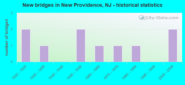
- New bridges - historical statistics
- 21920-1929
- 11930-1939
- 21950-1959
- 11960-1969
- 11970-1979
- 11980-1989
- 22000-2009

- Reconstructed bridges - Historical Statistics
- 11970-1979
- 01980-1989
- 01990-1999
- 12000-2009


- Bridge Condition - Deck
- 22.2%Good
- 55.6%Satisfactory
- 22.2%Fair

- Bridge Condition - Superstructure
- 11.1%Very good
- 11.1%Good
- 44.4%Satisfactory
- 22.2%Fair
- 11.1%Poor

- Bridge Condition - Substructure
- 33.3%Good
- 44.4%Satisfactory
- 22.2%Fair

- Bridge Condition - Channel
- 11.1%Very good
- 66.7%Good
- 22.2%Satisfactory
Find on map >> Show street view
Structure Number: 1400544, Location: 0.82 MI NORTH OF CR 638 (Lat: 40.701200, Lng: -74.475889), Route carried "on" structure: County highway 604, Year Built: 1988, Status: Open, Structure Length: 1.40m (4.59ft), Average Daily Traffic: 4,733 (year 2021), Truck Traffic: 3%, Average Future Daily Traffic: 5,679 (year 2041), Design Load: HS 20+Mod, Features Intersected: BLACK BROOK
Minimum Vertical Clearance: 30+ m (98+ ft), Kilometerpoint: 1.320, Lanes on structure: 2, Owner: County Highway Agency, Approaching Roadway Width: 7.6m (24.9ft), Material/Design: Prestressed concrete, Design/Construction: Slab, Number Of Spans In Main Unit: 1, Length of Maximum Span: 12.8m (42.0ft), Curb-To-Curb Width: 7.5m (24.6ft), Out-to-Out Width: 8.6m (28.2ft)
Condition: Deck: Satisfactory, Superstructure: Satisfactory, Substructure: Good, Channel: Good, Operating Rating: 49.0 metric tons, Method Used To Determine Operating Rating: Load Factor (LF), Inventory Rating: 29.0 metric tons, Method Used To Determine Inventory Rating: Load Factor (LF), Structural Evaluation: Equal to present minimum criteria, Deck Geometry: High priority of replacement, Waterway Adequacy: Equal to present minimum criteria, Approach Roadway Alignment: Meets minimum limits, Length Of Structure Improvement: 1.40m (4.59ft), Designated Inspection Frequency: Every 24 months, Inspection Date: September 2021, Bridge Improvement Cost: $194,000, Roadway Improvement Cost: $56,000, Total Project Cost: $387,000 ( Estimate for 2021), Deck Structure Type: Concrete Precast Panels, Wearing Surface/Protective System: Wearing Surface: Bituminous
Find on map >> Show street view
Structure Number: 2011007, Location: NEAR GALES DRIVE (Lat: 40.702839, Lng: -74.405381), Route carried "on" structure: County highway 647, Year Built: 2004, Status: Open, Structure Length: 0.98m (3.22ft), Average Daily Traffic: 13,970 (year 2020), Truck Traffic: 4%, Average Future Daily Traffic: 16,765 (year 2040), Design Load: HS 25 or greater, Features Intersected: SALT BROOK
Minimum Vertical Clearance: 30+ m (98+ ft), Kilometerpoint: 2.945, Lanes on structure: 2, Owner: County Highway Agency, Approaching Roadway Width: 12.2m (40.0ft), Skew: 3 degrees, Material/Design: Prestressed concrete, Design/Construction: Slab, Number Of Spans In Main Unit: 1, Length of Maximum Span: 7.9m (25.9ft), Curb or Sidewalk Widths: Left: 3.4m (11.2ft), Right: 3.4m (11.2ft), Curb-To-Curb Width: 12.2m (40.0ft), Out-to-Out Width: 20.1m (65.9ft)
Condition: Deck: Good, Superstructure: Very good, Substructure: Good, Channel: Good, Inventory Rating: 75.3 metric tons, Method Used To Determine Inventory Rating: Load Factor (LF), Structural Evaluation: Better than present minimum criteria, Deck Geometry: Somewhat better than minimum adequacy, Waterway Adequacy: Equal to present desirable criteria, Approach Roadway Alignment: Equal to present desirable criteria, Designated Inspection Frequency: Every 24 months, Inspection Date: March 2020, Deck Structure Type: Concrete Cast-file-Place, Wearing Surface/Protective System: Wearing Surface: Bituminous, Deck Protection: Galvanized Reinforcing
Find on map >> Show street view
Structure Number: 2011009, Location: NEAR MARION AVENUE (Lat: 40.701500, Lng: -74.398600), Route carried "on" structure: City street , Year Built: 1965, Status: Open, Structure Length: 1.10m (3.61ft), Average Daily Traffic: 3,794 (year 2020), Truck Traffic: 1%, Average Future Daily Traffic: 4,631 (year 2040), Design Load: HS 20+Mod, Features Intersected: SALT BROOK, Facility Carried by Structure: LIVINGSTON AVENUE
Minimum Vertical Clearance: 30+ m (98+ ft), Kilometerpoint: 0.000, Lanes on structure: 2, Owner: County Highway Agency, Approaching Roadway Width: 11.0m (36.1ft), Skew: 3 degrees, Material/Design: Prestressed concrete, Design/Construction: Slab, Number Of Spans In Main Unit: 1, Length of Maximum Span: 7.9m (25.9ft), Curb or Sidewalk Widths: Left: 3.9m (12.8ft), Right: 3.9m (12.8ft), Curb-To-Curb Width: 11.0m (36.1ft), Out-to-Out Width: 19.2m (63.0ft)
Condition: Deck: Satisfactory, Superstructure: Satisfactory, Substructure: Satisfactory, Channel: Good, Operating Rating: 53.5 metric tons, Method Used To Determine Operating Rating: Load Factor (LF), Inventory Rating: 31.8 metric tons, Method Used To Determine Inventory Rating: Load Factor (LF), Structural Evaluation: Equal to present minimum criteria, Deck Geometry: Somewhat better than minimum adequacy, Waterway Adequacy: Equal to present desirable criteria, Approach Roadway Alignment: Equal to present desirable criteria, Designated Inspection Frequency: Every 24 months, Inspection Date: March 2020, Deck Structure Type: Concrete Precast Panels, Wearing Surface/Protective System: Wearing Surface: Bituminous
Find on map >> Show street view
Structure Number: 2011039, Location: 1.5 MI SOUTH OF I-78 (Lat: 40.699300, Lng: -74.401850), Route carried "on" structure: County highway 647, Year Built: 1928, Year Reconstructed: 1984, Status: Open, Structure Length: 1.16m (3.81ft), Average Daily Traffic: 13,970 (year 2020), Truck Traffic: 4%, Average Future Daily Traffic: 16,765 (year 2040), Design Load: HS 25 or greater, Features Intersected: CENTRAL BR. SALT BROOK
Minimum Vertical Clearance: 30+ m (98+ ft), Kilometerpoint: 2.446, Lanes on structure: 2, Owner: County Highway Agency, Approaching Roadway Width: 13.1m (43.0ft), Skew: 5 degrees, Material/Design: Concrete, Design/Construction: Slab, Number Of Spans In Main Unit: 1, Length of Maximum Span: 9.1m (29.9ft), Curb or Sidewalk Widths: Left: 2.6m (8.5ft), Right: 3.4m (11.2ft), Curb-To-Curb Width: 13.1m (43.0ft), Out-to-Out Width: 19.7m (64.6ft)
Condition: Deck: Satisfactory, Superstructure: Satisfactory, Substructure: Satisfactory, Channel: Good, Inventory Rating: 65.3 metric tons, Method Used To Determine Inventory Rating: Load Factor (LF), Structural Evaluation: Equal to present minimum criteria, Deck Geometry: Somewhat better than minimum adequacy, Waterway Adequacy: Equal to present desirable criteria, Approach Roadway Alignment: Better than present minimum criteria, Designated Inspection Frequency: Every 24 months, Inspection Date: March 2020, Deck Structure Type: Concrete Cast-file-Place, Wearing Surface/Protective System: Wearing Surface: Bituminous, Membrane: Other, Deck Protection: Other
Find on map >> Show street view
Structure Number: 2011047, Location: 0.1 MILES WEST OF CR 647 (Lat: 40.705169, Lng: -74.408081), Route carried "on" structure: County highway 512, Year Built: 1958, Status: Open, Structure Length: 1.43m (4.69ft), Average Daily Traffic: 10,420 (year 2020), Truck Traffic: 4%, Average Future Daily Traffic: 12,504 (year 2040), Design Load: HS 20, Features Intersected: SALT BROOK
Minimum Vertical Clearance: 30+ m (98+ ft), Kilometerpoint: 45.818, Lanes on structure: 2, Owner: County Highway Agency, Approaching Roadway Width: 13.9m (45.6ft), Material/Design: Prestressed concrete, Design/Construction: Box Beam or Girders - Multiple, Number Of Spans In Main Unit: 2, Length of Maximum Span: 6.7m (22.0ft), Curb or Sidewalk Widths: Left: 1.5m (4.9ft), Right: 1.5m (4.9ft), Curb-To-Curb Width: 13.9m (45.6ft), Out-to-Out Width: 17.5m (57.4ft)
Condition: Deck: Fair, Superstructure: Fair, Substructure: Fair, Channel: Good, Operating Rating: 78.9 metric tons, Method Used To Determine Operating Rating: Load Factor (LF), Inventory Rating: 44.5 metric tons, Method Used To Determine Inventory Rating: Load Factor (LF), Structural Evaluation: Somewhat better than minimum adequacy, Deck Geometry: Superior to present desirable criteria, Waterway Adequacy: Equal to present desirable criteria, Approach Roadway Alignment: Better than present minimum criteria, Designated Inspection Frequency: Every 24 months, Inspection Date: March 2020, Deck Structure Type: Concrete Precast Panels, Wearing Surface/Protective System: Wearing Surface: Bituminous
Find on map >> Show street view
Structure Number: 2011055, Location: 0.24 MI SOUTH OF CR 512 (Lat: 40.710339, Lng: -74.384281), Route carried "on" structure: City street , Year Built: 2009, Status: Open, Structure Length: 0.61m (2.00ft), Average Daily Traffic: 5,854 (year 2020), Truck Traffic: 3%, Average Future Daily Traffic: 7,150 (year 2040), Design Load: HS 25 or greater, Features Intersected: SALT BROOK, Facility Carried by Structure: DIVISION AVENUE
Minimum Vertical Clearance: 30+ m (98+ ft), Kilometerpoint: 1.223, Lanes on structure: 2, Owner: County Highway Agency, Approaching Roadway Width: 9.8m (32.2ft), Material/Design: Concrete, Design/Construction: Culvert, Number Of Spans In Main Unit: 1, Length of Maximum Span: 6.1m (20.0ft), Curb or Sidewalk Widths: Left: 2.0m (6.6ft), Right: 2.0m (6.6ft), Curb-To-Curb Width: 9.8m (32.2ft), Out-to-Out Width: 14.9m (48.9ft)
Condition: Channel: Good, Culverts: Very good, Inventory Rating: 65.3 metric tons, Method Used To Determine Inventory Rating: Load Factor (LF), Structural Evaluation: Equal to present desirable criteria, Deck Geometry: Meets minimum limits, Waterway Adequacy: Meets minimum limits, Approach Roadway Alignment: Better than present minimum criteria, Designated Inspection Frequency: Every 24 months, Inspection Date: April 2020
Find on map >> Show street view
Structure Number: 201106, Location: 0.5 MI NORTH OF CO RT 512 (Lat: 40.713350, Lng: -74.407131), Route carried "on" structure: County highway 647, Year Built: 1976, Status: Open, Structure Length: 3.87m (12.70ft), Average Daily Traffic: 11,013 (year 2020), Truck Traffic: 4%, Average Future Daily Traffic: 13,131 (year 2040), Design Load: HS 20, Features Intersected: PASSAIC RIVER
Minimum Vertical Clearance: 30+ m (98+ ft), Kilometerpoint: 4.152, Lanes on structure: 2, Owner: County Highway Agency, Approaching Roadway Width: 14.0m (45.9ft), Skew: 3 degrees, Material/Design: Prestressed concrete, Design/Construction: Box Beam or Girders - Multiple, Number Of Spans In Main Unit: 2, Length of Maximum Span: 18.6m (61.0ft), Curb or Sidewalk Widths: Left: 1.8m (5.9ft), Right: 1.9m (6.2ft), Curb-To-Curb Width: 14.0m (45.9ft), Out-to-Out Width: 18.4m (60.4ft)
Condition: Deck: Satisfactory, Superstructure: Poor, Substructure: Satisfactory, Channel: Satisfactory, Operating Rating: 54.4 metric tons, Method Used To Determine Operating Rating: Load Factor (LF), Inventory Rating: 31.8 metric tons, Method Used To Determine Inventory Rating: Load Factor (LF), Structural Evaluation: Meets minimum limits, Deck Geometry: Superior to present desirable criteria, Waterway Adequacy: Better than present minimum criteria, Approach Roadway Alignment: Better than present minimum criteria, Length Of Structure Improvement: 3.87m (12.70ft), Designated Inspection Frequency: Every 24 months, Inspection Date: March 2020, Bridge Improvement Cost: $1,600,000, Roadway Improvement Cost: $100,000, Total Project Cost: $2,523,000 ( Estimate for 2020), Deck Structure Type: Concrete Cast-file-Place, Wearing Surface/Protective System: Wearing Surface: Epoxy Overlay
Find on map >> Show street view
Structure Number: 2011062, Location: 0.4 MI WEST OF CR 512 (Lat: 40.701231, Lng: -74.426481), Route carried "on" structure: City street , Year Built: 1928, Year Reconstructed: 2008, Status: Open, Structure Length: 2.74m (8.99ft), Average Daily Traffic: 6,390 (year 2020), Truck Traffic: 3%, Average Future Daily Traffic: 7,798 (year 2040), Design Load: HS 25 or greater, Features Intersected: PASSAIC RIVER, Facility Carried by Structure: CENTRAL AVENUE
Minimum Vertical Clearance: 30+ m (98+ ft), Kilometerpoint: 0.000, Lanes on structure: 2, Owner: County Highway Agency, Approaching Roadway Width: 10.5m (34.4ft), Material/Design: Prestressed concrete, Design/Construction: Box Beam or Girders - Multiple, Number Of Spans In Main Unit: 2, Length of Maximum Span: 12.8m (42.0ft), Curb or Sidewalk Widths: Left: 1.8m (5.9ft), Right: 1.8m (5.9ft), Curb-To-Curb Width: 10.5m (34.4ft), Out-to-Out Width: 14.8m (48.6ft)
Condition: Deck: Good, Superstructure: Good, Substructure: Good, Channel: Very good, Operating Rating: 89.8 metric tons, Method Used To Determine Operating Rating: Load Factor (LF), Inventory Rating: 53.5 metric tons, Method Used To Determine Inventory Rating: Load Factor (LF), Structural Evaluation: Better than present minimum criteria, Deck Geometry: Meets minimum limits, Waterway Adequacy: Better than present minimum criteria, Approach Roadway Alignment: Equal to present desirable criteria, Designated Inspection Frequency: Every 24 months, Underwater Inspection Frequency: Every 48 months, Inspection Date: March 2020, Underwater Inspection Date: April 2018, Deck Structure Type: Concrete Cast-file-Place, Wearing Surface/Protective System: Wearing Surface: Other, Deck Protection: Galvanized Reinforcing
Find on map >> Show street view
Structure Number: 2011073, Location: NEAR BROOKSIDE ROAD (Lat: 40.703611, Lng: -74.392950), Route carried "on" structure: City street , Year Built: 1959, Status: Open, Structure Length: 0.67m (2.20ft), Average Daily Traffic: 398 (year 2020), Truck Traffic: 1%, Average Future Daily Traffic: 484 (year 2040), Features Intersected: SALT BROOK, Facility Carried by Structure: CONSTANCE ROAD
Minimum Vertical Clearance: 30+ m (98+ ft), Kilometerpoint: 0.000, Lanes on structure: 2, Owner: City or Municipal Highway Agency, Approaching Roadway Width: 9.2m (30.2ft), Material/Design: Prestressed concrete, Design/Construction: Slab, Number Of Spans In Main Unit: 1, Length of Maximum Span: 6.4m (21.0ft), Curb or Sidewalk Widths: Left: 2.4m (7.9ft), Right: 2.4m (7.9ft), Curb-To-Curb Width: 9.2m (30.2ft), Out-to-Out Width: 14.1m (46.3ft)
Condition: Deck: Fair, Superstructure: Fair, Substructure: Satisfactory, Channel: Satisfactory, Operating Rating: 54.4 metric tons, Method Used To Determine Operating Rating: Field evaluation and documented engineering judgment, Inventory Rating: 32.7 metric tons, Method Used To Determine Inventory Rating: Field evaluation and documented engineering judgment, Structural Evaluation: Somewhat better than minimum adequacy, Deck Geometry: Equal to present minimum criteria, Waterway Adequacy: Equal to present desirable criteria, Approach Roadway Alignment: Equal to present desirable criteria, Designated Inspection Frequency: Every 24 months, Inspection Date: April 2020, Deck Structure Type: Concrete Precast Panels, Wearing Surface/Protective System: Wearing Surface: Bituminous
Find on map >> Show street view
Structure Number: 2061151, Location: 3.2 MI W I78 & NJ24 JCT (Lat: 40.713000, Lng: -74.385650), Route carried "on" structure: County highway 512, Year Built: 1931, Status: Open, Structure Length: 1.55m (5.09ft), Average Daily Traffic: 10,948 (year 2021), Truck Traffic: 4%, Average Future Daily Traffic: 13,358 (year 2041), Features Intersected: GLADSTONE LINE
Minimum Vertical Clearance: 30+ m (98+ ft), Kilometerpoint: 47.991, Lanes on structure: 2, Owner: State Agenciy, Approaching Roadway Width: 12.2m (40.0ft), Skew: 3 degrees, Material/Design: Concrete, Design/Construction: Slab, Number Of Spans In Main Unit: 1, Length of Maximum Span: 14.0m (45.9ft), Curb or Sidewalk Widths: Left: 2.7m (8.9ft), Right: 2.7m (8.9ft), Curb-To-Curb Width: 12.2m (40.0ft), Out-to-Out Width: 18.3m (60.0ft)
Condition: Deck: Satisfactory, Superstructure: Satisfactory, Substructure: Fair, Operating Rating: 89.8 metric tons, Method Used To Determine Operating Rating: Load Factor (LF), Inventory Rating: 58.1 metric tons, Method Used To Determine Inventory Rating: Load Factor (LF), Structural Evaluation: Somewhat better than minimum adequacy, Deck Geometry: Somewhat better than minimum adequacy, Underclear: High priority of replacement, Approach Roadway Alignment: Equal to present minimum criteria, Length Of Structure Improvement: 2.29m (7.51ft), Designated Inspection Frequency: Every 24 months, Inspection Date: Febuary 2021, Bridge Improvement Cost: $3,343,000, Roadway Improvement Cost: $836,000, Total Project Cost: $12,535,000 ( Estimate for 2021), Deck Structure Type: Concrete Cast-file-Place, Wearing Surface/Protective System: Wearing Surface: Bituminous