Bridge Statistics for New London, Connecticut (CT)
Condition, Traffic, Stress, Structural Evaluation, Project Costs
- National Bridge Inventory (NBI) Statistics
- 57Number of bridges
- 1,129ft / 344mTotal length
- $13,800,000Total costs
- 790,223Total average daily traffic
- 76,365Total average daily truck traffic
- National Bridge Inventory (NBI) Registered Bridges for New London
- No street view available for this location
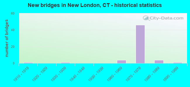
- New bridges - historical statistics
- 11910-1919
- 11930-1939
- 41960-1969
- 461970-1979
- 41980-1989
- 11990-1999

- Reconstructed bridges - Historical Statistics
- 11960-1969
- 01970-1979
- 01980-1989
- 11990-1999


- Bridge Condition - Deck
- 36.8%Good
- 36.8%Satisfactory
- 26.3%Fair

- Bridge Condition - Superstructure
- 26.3%Good
- 31.6%Satisfactory
- 31.6%Fair
- 10.5%Poor

- Bridge Condition - Substructure
- 26.3%Good
- 73.7%Satisfactory

- Bridge Condition - Channel
- 50.0%Good
- 50.0%Satisfactory

- Bridge Condition - Culverts
- 50.0%Good
- 50.0%Satisfactory
Find on map >> Show street view
Structure Number: 354, Location: 0.6 MI NORTH OF ROUTE 85 (Lat: 41.370728, Lng: -72.122369), Route carried "on" structure: City street , Year Built: 1960, Status: Open, Structure Length: 10.45m (34.28ft), Average Daily Traffic: 6,365 (year 2020), Truck Traffic: 4%, Average Future Daily Traffic: 9,458 (year 2040), Design Load: HS 20, Features Intersected: I-95, SR 623 & SR 624, Facility Carried by Structure: VAUXHALL ST EXT
Minimum Vertical Clearance: 30+ m (98+ ft), Kilometerpoint: 0.435, Lanes on structure: 2, Lanes under structure: 7, Owner: State Highway Agency, Approaching Roadway Width: 12.2m (40.0ft), Skew: 5 degrees, Material/Design: Steel, Design/Construction: Stringer/Multi-beam, Number Of Spans In Main Unit: 4, Length of Maximum Span: 25.9m (85.0ft), Curb or Sidewalk Widths: Left: 0.5m (1.6ft), Right: 1.5m (4.9ft), Curb-To-Curb Width: 12.2m (40.0ft), Out-to-Out Width: 15.0m (49.2ft)
Condition: Deck: Fair, Superstructure: Satisfactory, Substructure: Satisfactory, Operating Rating: 71.9 metric tons, Method Used To Determine Operating Rating: Load and Resistance Factor Rating (LRFR) rating reported by rating factor(RF) method using HL-93 loadings, Inventory Rating: 55.4 metric tons, Method Used To Determine Inventory Rating: Load and Resistance Factor Rating (LRFR) rating reported by rating factor(RF) method using HL-93 loadings, Structural Evaluation: Equal to present minimum criteria, Deck Geometry: Somewhat better than minimum adequacy, Underclear: High priority of corrective action, Approach Roadway Alignment: Equal to present minimum criteria, Designated Inspection Frequency: Every 24 months, Inspection Date: May 2020, Deck Structure Type: Concrete Cast-file-Place, Wearing Surface/Protective System: Wearing Surface: Bituminous, Membrane: Preformed Fabric
Find on map >> Show street view
Structure Number: 2514A, Location: O/THAMES RV LOC ROAD & RR (Lat: 41.364217, Lng: -72.091222), Route carried "on" structure: Interstate 95, Year Built: 1973, Status: Open, Structure Length: 194.10m (636.81ft), Average Daily Traffic: 43,700 (year 2020), Truck Traffic: 14%, Average Future Daily Traffic: 64,934 (year 2040), Design Load: HS 20, Features Intersected: THAMES RV LOC RDS & RR
Minimum Vertical Clearance: 7.01m (23.00ft), Kilometerpoint: 151.745, Lanes on structure: 4, Lanes under structure: 12, Base Highway Network: Yes, Owner: State Highway Agency, Approaching Roadway Width: 20.7m (67.9ft), Skew: 9 degrees, Navigation Control: Yes ( Vertical Clearance: 41.1m (134.8ft), Horizontal Clearance: 61.0m (200.1ft)), Material/Design: Steel continuous, Design/Construction: Truss - Deck, Number Of Spans In Main Unit: 11, Number Of Approach Spans: 19, Length of Maximum Span: 164.6m (540.0ft), Curb or Sidewalk Widths: Left: 1.4m (4.6ft), Right: 0.0m, Curb-To-Curb Width: 20.7m (67.9ft), Out-to-Out Width: 21.9m (71.9ft)
Condition: Deck: Satisfactory, Superstructure: Fair, Substructure: Satisfactory, Channel: Satisfactory, Operating Rating: 49.1 metric tons, Method Used To Determine Operating Rating: Load Factor (LF), Inventory Rating: 29.4 metric tons, Method Used To Determine Inventory Rating: Load Factor (LF), Structural Evaluation: Somewhat better than minimum adequacy, Deck Geometry: Equal to present minimum criteria, Underclear: Somewhat better than minimum adequacy, Waterway Adequacy: Superior to present desirable criteria, Approach Roadway Alignment: Better than present minimum criteria, Designated Inspection Frequency: Every 24 months, Critical Feature Inspection Frequency: Every 24 months, Underwater Inspection Frequency: Every 24 months, Inspection Date: June 2021, Critical Feature Inspection Date: June 2021, Underwater Inspection Date: June 2021, Deck Structure Type: Concrete Cast-file-Place, Wearing Surface/Protective System: Wearing Surface: Bituminous, Membrane: Built-up
Find on map >> Show street view
Structure Number: 2514B, Location: EXIT 84 I-95 SOUTH (Lat: 41.365139, Lng: -72.101939), Route carried "on" structure: Ramp Interstate 95, Year Built: 1975, Status: Open, Structure Length: 11.03m (36.19ft), Average Daily Traffic: 17,600 (year 2017), Truck Traffic: 9%, Average Future Daily Traffic: 26,152 (year 2037), Design Load: HS 20, Features Intersected: SR 635 & STATE PIER RD
Minimum Vertical Clearance: 30+ m (98+ ft), Kilometerpoint: 0.724, Lanes on structure: 2, Lanes under structure: 4, Owner: State Highway Agency, Approaching Roadway Width: 12.2m (40.0ft), Skew: 9 degrees, Material/Design: Steel, Design/Construction: Stringer/Multi-beam, Number Of Spans In Main Unit: 3, Length of Maximum Span: 38.4m (126.0ft), Curb or Sidewalk Widths: Left: 1.8m (5.9ft), Right: 0.0m, Curb-To-Curb Width: 12.2m (40.0ft), Out-to-Out Width: 15.1m (49.5ft)
Condition: Deck: Satisfactory, Superstructure: Satisfactory, Substructure: Satisfactory, Operating Rating: 98.8 metric tons, Method Used To Determine Operating Rating: Load Factor (LF), Inventory Rating: 59.2 metric tons, Method Used To Determine Inventory Rating: Load Factor (LF), Structural Evaluation: Equal to present minimum criteria, Deck Geometry: Superior to present desirable criteria, Underclear: Better than present minimum criteria, Approach Roadway Alignment: Somewhat better than minimum adequacy, Designated Inspection Frequency: Every 24 months, Inspection Date: July 2021, Deck Structure Type: Concrete Cast-file-Place, Wearing Surface/Protective System: Wearing Surface: Bituminous, Membrane: Preformed Fabric
Find on map >> Show street view
Structure Number: 2572, Location: 0.1 MI N OF I-95 (Lat: 41.365303, Lng: -72.107942), Route carried "on" structure: US 1, Year Built: 1973, Status: Open, Structure Length: 9.16m (30.05ft), Average Daily Traffic: 4,200 (year 2017), Truck Traffic: 6%, Average Future Daily Traffic: 6,241 (year 2037), Design Load: HS 20, Features Intersected: I-95 RAMP 310,SR 641 SB
Minimum Vertical Clearance: 30+ m (98+ ft), Kilometerpoint: 162.125, Lanes on structure: 1, Lanes under structure: 2, Base Highway Network: Yes, Owner: State Highway Agency, Approaching Roadway Width: 7.3m (24.0ft), Skew: 5 degrees, Material/Design: Steel continuous, Design/Construction: Stringer/Multi-beam, Number Of Spans In Main Unit: 2, Length of Maximum Span: 46.8m (153.5ft), Curb-To-Curb Width: 7.3m (24.0ft), Out-to-Out Width: 8.5m (27.9ft)
Condition: Deck: Satisfactory, Superstructure: Poor, Substructure: Good, Operating Rating: 36.9 metric tons, Method Used To Determine Operating Rating: Load and Resistance Factor Rating (LRFR) rating reported by rating factor(RF) method using HL-93 loadings, Inventory Rating: 28.5 metric tons, Method Used To Determine Inventory Rating: Load and Resistance Factor Rating (LRFR) rating reported by rating factor(RF) method using HL-93 loadings, Structural Evaluation: Meets minimum limits, Deck Geometry: High priority of replacement, Underclear: Equal to present minimum criteria, Approach Roadway Alignment: Equal to present minimum criteria, Designated Inspection Frequency: Every 24 months, Inspection Date: December 2020, Total Project Cost: $13,800,000, Deck Structure Type: Concrete Cast-file-Place, Wearing Surface/Protective System: Wearing Surface: Bituminous, Membrane: Built-up
Find on map >> Show street view
Structure Number: 2602, Location: 0.6 MI N OF ROUTE 85 (Lat: 41.368742, Lng: -72.115761), Route carried "on" structure: State highway 908, Year Built: 1973, Status: Open, Structure Length: 10.29m (33.76ft), Average Daily Traffic: 11,700 (year 2017), Truck Traffic: 6%, Average Future Daily Traffic: 17,385 (year 2037), Design Load: HS 20, Features Intersected: I-95, SR 623 & N SR 624
Minimum Vertical Clearance: 30+ m (98+ ft), Kilometerpoint: 0.064, Lanes on structure: 4, Lanes under structure: 12, Base Highway Network: Yes, Owner: State Highway Agency, Approaching Roadway Width: 16.2m (53.1ft), Material/Design: Steel, Design/Construction: Stringer/Multi-beam, Number Of Spans In Main Unit: 4, Length of Maximum Span: 26.8m (87.9ft), Curb or Sidewalk Widths: Left: 2.7m (8.9ft), Right: 0.0m, Curb-To-Curb Width: 16.2m (53.1ft), Out-to-Out Width: 19.9m (65.3ft)
Condition: Deck: Satisfactory, Superstructure: Satisfactory, Substructure: Satisfactory, Operating Rating: 56.4 metric tons, Method Used To Determine Operating Rating: Load and Resistance Factor Rating (LRFR) rating reported by rating factor(RF) method using HL-93 loadings, Inventory Rating: 43.4 metric tons, Method Used To Determine Inventory Rating: Load and Resistance Factor Rating (LRFR) rating reported by rating factor(RF) method using HL-93 loadings, Structural Evaluation: Equal to present minimum criteria, Deck Geometry: Meets minimum limits, Underclear: Equal to present minimum criteria, Approach Roadway Alignment: Equal to present minimum criteria, Designated Inspection Frequency: Every 24 months, Inspection Date: April 2021, Deck Structure Type: Concrete Cast-file-Place, Wearing Surface/Protective System: Wearing Surface: Bituminous, Membrane: Other
Find on map >> Show street view
Structure Number: 2603, Location: 0.39 MI S OF ROUTE 32 INT (Lat: 41.366111, Lng: -72.108611), Route carried "on" structure: Alternate State highway 636, Year Built: 1973, Status: Open, Structure Length: 11.15m (36.58ft), Average Daily Traffic: 6,900 (year 2017), Truck Traffic: 3%, Average Future Daily Traffic: 10,253 (year 2037), Design Load: HS 20, Features Intersected: I-95&SR623+641&I-95 310
Minimum Vertical Clearance: 30+ m (98+ ft), Kilometerpoint: 0.129, Lanes on structure: 4, Lanes under structure: 11, Owner: State Highway Agency, Approaching Roadway Width: 16.2m (53.1ft), Skew: 9 degrees, Material/Design: Steel, Design/Construction: Stringer/Multi-beam, Number Of Spans In Main Unit: 4, Length of Maximum Span: 35.4m (116.1ft), Curb or Sidewalk Widths: Left: 4.0m (13.1ft), Right: 0.0m, Curb-To-Curb Width: 16.2m (53.1ft), Out-to-Out Width: 21.1m (69.2ft)
Condition: Deck: Satisfactory, Superstructure: Fair, Substructure: Satisfactory, Operating Rating: 76.2 metric tons, Method Used To Determine Operating Rating: Load Factor (LF), Inventory Rating: 45.4 metric tons, Method Used To Determine Inventory Rating: Load Factor (LF), Structural Evaluation: Somewhat better than minimum adequacy, Deck Geometry: Meets minimum limits, Underclear: Equal to present minimum criteria, Approach Roadway Alignment: Equal to present desirable criteria, Designated Inspection Frequency: Every 24 months, Inspection Date: May 2021, Deck Structure Type: Concrete Cast-file-Place, Wearing Surface/Protective System: Wearing Surface: Bituminous, Membrane: Built-up
Find on map >> Show street view
Structure Number: 2611, Location: 1.4 MILE N OF ROUTE 85 (Lat: 41.366281, Lng: -72.108128), Route carried "on" structure: Ramp State highway 32, Year Built: 1973, Status: Open, Structure Length: 9.69m (31.79ft), Average Daily Traffic: 8,600 (year 2017), Truck Traffic: 8%, Average Future Daily Traffic: 12,779 (year 2037), Design Load: HS 20, Features Intersected: INTERSTATE 95 & SR 623
Minimum Vertical Clearance: 30+ m (98+ ft), Kilometerpoint: 0.145, Lanes on structure: 1, Lanes under structure: 9, Owner: State Highway Agency, Approaching Roadway Width: 7.9m (25.9ft), Skew: 3 degrees, Material/Design: Steel continuous, Design/Construction: Stringer/Multi-beam, Number Of Spans In Main Unit: 3, Length of Maximum Span: 35.7m (117.1ft), Curb-To-Curb Width: 7.9m (25.9ft), Out-to-Out Width: 9.1m (29.9ft)
Condition: Deck: Satisfactory, Superstructure: Fair, Substructure: Satisfactory, Operating Rating: 58.4 metric tons, Method Used To Determine Operating Rating: Load Factor (LF), Inventory Rating: 35.3 metric tons, Method Used To Determine Inventory Rating: Load Factor (LF), Structural Evaluation: Somewhat better than minimum adequacy, Deck Geometry: Equal to present desirable criteria, Underclear: Equal to present minimum criteria, Approach Roadway Alignment: Somewhat better than minimum adequacy, Designated Inspection Frequency: Every 24 months, Inspection Date: March 2021, Deck Structure Type: Concrete Cast-file-Place, Wearing Surface/Protective System: Wearing Surface: Monolithic Concrete
Find on map >> Show street view
Structure Number: 2612, Location: 0.47 MI N OF JCT SSR 437 (Lat: 41.365203, Lng: -72.105972), Route carried "on" structure: State highway 32, Year Built: 1974, Status: Open, Structure Length: 22.56m (74.02ft), Average Daily Traffic: 10,500 (year 2017), Truck Traffic: 8%, Average Future Daily Traffic: 15,602 (year 2037), Design Load: HS 20, Features Intersected: I-95, US 1 NB,SR 623&641
Minimum Vertical Clearance: 30+ m (98+ ft), Kilometerpoint: 0.756, Lanes on structure: 3, Lanes under structure: 13, Base Highway Network: Yes, Owner: State Highway Agency, Approaching Roadway Width: 15.2m (49.9ft), Skew: 4 degrees, Material/Design: Steel, Design/Construction: Stringer/Multi-beam, Number Of Spans In Main Unit: 6, Length of Maximum Span: 37.5m (123.0ft), Curb-To-Curb Width: 15.2m (49.9ft), Out-to-Out Width: 16.4m (53.8ft)
Condition: Deck: Fair, Superstructure: Fair, Substructure: Satisfactory, Operating Rating: 90.2 metric tons, Method Used To Determine Operating Rating: Load Factor (LF), Inventory Rating: 54.1 metric tons, Method Used To Determine Inventory Rating: Load Factor (LF), Structural Evaluation: Somewhat better than minimum adequacy, Deck Geometry: Equal to present minimum criteria, Underclear: Equal to present minimum criteria, Approach Roadway Alignment: Equal to present desirable criteria, Designated Inspection Frequency: Every 24 months, Inspection Date: August 2021, Deck Structure Type: Concrete Cast-file-Place, Wearing Surface/Protective System: Wearing Surface: Bituminous
Find on map >> Show street view
Structure Number: 2833, Location: 1.6 MI N OF ROUTE 85 (Lat: 41.365008, Lng: -72.105275), Route carried "on" structure: State highway 32, Year Built: 1974, Status: Open, Structure Length: 23.29m (76.41ft), Average Daily Traffic: 4,900 (year 2017), Truck Traffic: 8%, Average Future Daily Traffic: 7,281 (year 2037), Design Load: HS 20, Features Intersected: I-95,US 1 NB,SR 623&641
Minimum Vertical Clearance: 6.48m (21.26ft), Kilometerpoint: 0.708, Lanes on structure: 3, Lanes under structure: 13, Base Highway Network: Yes, Owner: State Highway Agency, Approaching Roadway Width: 15.2m (49.9ft), Skew: 4 degrees, Material/Design: Steel, Design/Construction: Stringer/Multi-beam, Number Of Spans In Main Unit: 6, Length of Maximum Span: 40.4m (132.5ft), Curb-To-Curb Width: 15.2m (49.9ft), Out-to-Out Width: 16.4m (53.8ft)
Condition: Deck: Fair, Superstructure: Poor, Substructure: Satisfactory, Inventory Rating: 60.9 metric tons, Method Used To Determine Inventory Rating: Load Factor (LF), Structural Evaluation: Meets minimum limits, Deck Geometry: Meets minimum limits, Underclear: Equal to present minimum criteria, Approach Roadway Alignment: Equal to present desirable criteria, Designated Inspection Frequency: Every 24 months, Inspection Date: August 2021, Deck Structure Type: Concrete Cast-file-Place, Wearing Surface/Protective System: Wearing Surface: Bituminous
Find on map >> Show street view
Structure Number: 2864, Location: 0.2 MI N OF ROUTE 32 (Lat: 41.363553, Lng: -72.102597), Route carried "on" structure: Ramp Interstate 95, Year Built: 1975, Status: Open, Structure Length: 3.62m (11.88ft), Average Daily Traffic: 10,200 (year 2017), Truck Traffic: 9%, Average Future Daily Traffic: 15,156 (year 2037), Design Load: HS 20, Features Intersected: SR 641
Minimum Vertical Clearance: 30+ m (98+ ft), Kilometerpoint: 0.032, Lanes on structure: 1, Lanes under structure: 3, Owner: State Highway Agency, Approaching Roadway Width: 10.4m (34.1ft), Skew: 1 degrees, Material/Design: Steel, Design/Construction: Stringer/Multi-beam, Number Of Spans In Main Unit: 1, Length of Maximum Span: 34.4m (112.9ft), Curb or Sidewalk Widths: Left: 0.0m, Right: 1.2m (3.9ft), Curb-To-Curb Width: 10.2m (33.5ft), Out-to-Out Width: 12.7m (41.7ft)
Condition: Deck: Good, Superstructure: Fair, Substructure: Satisfactory, Operating Rating: 89.8 metric tons, Method Used To Determine Operating Rating: Load Factor (LF), Inventory Rating: 57.1 metric tons, Method Used To Determine Inventory Rating: Load Factor (LF), Structural Evaluation: Somewhat better than minimum adequacy, Deck Geometry: Superior to present desirable criteria, Underclear: Better than present minimum criteria, Approach Roadway Alignment: Equal to present minimum criteria, Designated Inspection Frequency: Every 24 months, Inspection Date: April 2021, Deck Structure Type: Concrete Cast-file-Place, Wearing Surface/Protective System: Wearing Surface: Bituminous
Find on map >> Show street view
Structure Number: 2887, Location: 475 FT E OF ROUTE 32 (Lat: 41.361353, Lng: -72.097625), Route carried "on" structure: ServiceState highway 437, Year Built: 1973, Status: Open, Structure Length: 1.34m (4.40ft), Average Daily Traffic: 2,600 (year 2017), Truck Traffic: 4%, Average Future Daily Traffic: 3,863 (year 2037), Design Load: HS 20, Features Intersected: WINTHROP COVE
Minimum Vertical Clearance: 30+ m (98+ ft), Kilometerpoint: 0.129, Lanes on structure: 4, Owner: State Highway Agency, Approaching Roadway Width: 10.4m (34.1ft), Skew: 3 degrees, Material/Design: Concrete continuous, Design/Construction: Culvert, Number Of Spans In Main Unit: 2, Length of Maximum Span: 6.4m (21.0ft), Curb or Sidewalk Widths: Left: 1.5m (4.9ft), Right: 1.5m (4.9ft)
Condition: Channel: Good, Culverts: Good, Operating Rating: 35.6 metric tons, Method Used To Determine Operating Rating: Load and Resistance Factor Rating (LRFR) rating reported by rating factor(RF) method using HL-93 loadings, Inventory Rating: 27.5 metric tons, Method Used To Determine Inventory Rating: Load and Resistance Factor Rating (LRFR) rating reported by rating factor(RF) method using HL-93 loadings, Structural Evaluation: Equal to present minimum criteria, Waterway Adequacy: Equal to present desirable criteria, Approach Roadway Alignment: Better than present minimum criteria, Designated Inspection Frequency: Every 48 months, Inspection Date: June 2020
Find on map >> Show street view
Structure Number: 2888, Location: 0.8 MI N OF I-95 (Lat: 41.370333, Lng: -72.104586), Route carried "on" structure: State highway 636, Year Built: 1973, Status: Open, Structure Length: 7.44m (24.41ft), Average Daily Traffic: 3,700 (year 2017), Truck Traffic: 5%, Average Future Daily Traffic: 5,498 (year 2037), Design Load: HS 20, Features Intersected: ROUTE 32 & I-95SB TR 817
Minimum Vertical Clearance: 30+ m (98+ ft), Kilometerpoint: 0.756, Lanes on structure: 2, Lanes under structure: 5, Owner: State Highway Agency, Approaching Roadway Width: 9.4m (30.8ft), Skew: 3 degrees, Material/Design: Steel continuous, Design/Construction: Stringer/Multi-beam, Number Of Spans In Main Unit: 2, Length of Maximum Span: 39.6m (129.9ft), Curb or Sidewalk Widths: Left: 0.0m, Right: 1.7m (5.6ft), Curb-To-Curb Width: 9.4m (30.8ft), Out-to-Out Width: 12.1m (39.7ft)
Condition: Deck: Satisfactory, Superstructure: Satisfactory, Substructure: Good, Operating Rating: 78.7 metric tons, Method Used To Determine Operating Rating: Load Factor (LF), Inventory Rating: 47.3 metric tons, Method Used To Determine Inventory Rating: Load Factor (LF), Structural Evaluation: Equal to present minimum criteria, Deck Geometry: Meets minimum limits, Underclear: Somewhat better than minimum adequacy, Approach Roadway Alignment: Somewhat better than minimum adequacy, Designated Inspection Frequency: Every 24 months, Inspection Date: November 2020, Deck Structure Type: Concrete Cast-file-Place, Wearing Surface/Protective System: Wearing Surface: Bituminous, Membrane: Built-up
Find on map >> Show street view
Structure Number: 2897, Location: 0.4 MI N OF I-95 (Lat: 41.371011, Lng: -72.104008), Route carried "on" structure: State highway 635, Year Built: 1973, Status: Open, Structure Length: 7.99m (26.21ft), Average Daily Traffic: 6,200 (year 2017), Truck Traffic: 4%, Average Future Daily Traffic: 9,213 (year 2037), Design Load: HS 20, Features Intersected: RT 32+RAMP 3,I-95 TR 817
Minimum Vertical Clearance: 30+ m (98+ ft), Kilometerpoint: 0.805, Lanes on structure: 3, Lanes under structure: 6, Owner: State Highway Agency, Approaching Roadway Width: 13.4m (44.0ft), Skew: 2 degrees, Material/Design: Steel continuous, Design/Construction: Stringer/Multi-beam, Number Of Spans In Main Unit: 2, Length of Maximum Span: 42.7m (140.1ft), Curb or Sidewalk Widths: Left: 1.7m (5.6ft), Right: 1.7m (5.6ft), Curb-To-Curb Width: 13.4m (44.0ft), Out-to-Out Width: 17.5m (57.4ft)
Condition: Deck: Good, Superstructure: Satisfactory, Substructure: Satisfactory, Operating Rating: 34.7 metric tons, Method Used To Determine Operating Rating: Load and Resistance Factor Rating (LRFR) rating reported by rating factor(RF) method using HL-93 loadings, Inventory Rating: 26.9 metric tons, Method Used To Determine Inventory Rating: Load and Resistance Factor Rating (LRFR) rating reported by rating factor(RF) method using HL-93 loadings, Structural Evaluation: Equal to present minimum criteria, Deck Geometry: Somewhat better than minimum adequacy, Underclear: High priority of corrective action, Approach Roadway Alignment: Equal to present minimum criteria, Designated Inspection Frequency: Every 24 months, Inspection Date: November 2020, Deck Structure Type: Concrete Cast-file-Place, Wearing Surface/Protective System: Wearing Surface: Bituminous, Membrane: Built-up
Find on map >> Show street view
Structure Number: 2898, Location: 1.0 MI S OF US ROUTE 1 (Lat: 41.334717, Lng: -72.104858), Route carried "on" structure: State highway 213, Year Built: 1930, Year Reconstructed: 1973, Status: Open, Structure Length: 1.07m (3.51ft), Average Daily Traffic: 10,900 (year 2016), Truck Traffic: 5%, Average Future Daily Traffic: 16,196 (year 2036), Design Load: HS 20, Features Intersected: AMTRAK RAILROAD
Minimum Vertical Clearance: 30+ m (98+ ft), Kilometerpoint: 9.077, Lanes on structure: 2, Owner: State Highway Agency, Approaching Roadway Width: 9.1m (29.9ft), Material/Design: Prestressed concrete, Design/Construction: Slab, Number Of Spans In Main Unit: 1, Length of Maximum Span: 9.4m (30.8ft), Curb or Sidewalk Widths: Left: 1.7m (5.6ft), Right: 1.7m (5.6ft), Curb-To-Curb Width: 9.1m (29.9ft), Out-to-Out Width: 13.3m (43.6ft)
Condition: Deck: Good, Superstructure: Good, Substructure: Good, Operating Rating: 59.2 metric tons, Method Used To Determine Operating Rating: Load Factor (LF), Inventory Rating: 35.5 metric tons, Method Used To Determine Inventory Rating: Load Factor (LF), Structural Evaluation: Better than present minimum criteria, Deck Geometry: High priority of corrective action, Underclear: High priority of corrective action, Approach Roadway Alignment: Equal to present desirable criteria, Designated Inspection Frequency: Every 48 months, Inspection Date: Febuary 2018, Deck Structure Type: Other, Wearing Surface/Protective System: Wearing Surface: Bituminous, Membrane: Built-up
Find on map >> Show street view
Structure Number: 382, Location: 0.1 MI W OF THAMES RIVER (Lat: 41.364350, Lng: -72.102764), Route carried "on" structure: Interstate 95, Year Built: 1975, Status: Open, Structure Length: 3.75m (12.30ft), Average Daily Traffic: 41,300 (year 2017), Truck Traffic: 14%, Average Future Daily Traffic: 61,368 (year 2037), Design Load: HS 20, Features Intersected: WILLIAMS ST (SR 635)
Minimum Vertical Clearance: 30+ m (98+ ft), Kilometerpoint: 150.441, Lanes on structure: 4, Lanes under structure: 3, Base Highway Network: Yes, Owner: State Highway Agency, Approaching Roadway Width: 22.3m (73.2ft), Material/Design: Steel, Design/Construction: Stringer/Multi-beam, Number Of Spans In Main Unit: 1, Length of Maximum Span: 36.1m (118.4ft), Curb-To-Curb Width: 22.4m (73.5ft), Out-to-Out Width: 23.6m (77.4ft)
Condition: Deck: Good, Superstructure: Good, Substructure: Satisfactory, Operating Rating: 45.0 metric tons, Method Used To Determine Operating Rating: Load and Resistance Factor Rating (LRFR) rating reported by rating factor(RF) method using HL-93 loadings, Inventory Rating: 34.7 metric tons, Method Used To Determine Inventory Rating: Load and Resistance Factor Rating (LRFR) rating reported by rating factor(RF) method using HL-93 loadings, Structural Evaluation: Equal to present minimum criteria, Deck Geometry: Superior to present desirable criteria, Underclear: Equal to present minimum criteria, Approach Roadway Alignment: Equal to present desirable criteria, Designated Inspection Frequency: Every 24 months, Inspection Date: August 2021, Deck Structure Type: Concrete Cast-file-Place, Wearing Surface/Protective System: Wearing Surface: Bituminous
Find on map >> Show street view
Structure Number: 4311, Location: 0.2 MI E OF ROUTE 213 (Lat: 41.317297, Lng: -72.103572), Route carried "on" structure: City street , Year Built: 1980, Status: Open, Structure Length: 3.38m (11.09ft), Average Daily Traffic: 1,700 (year 2020), Truck Traffic: 4%, Average Future Daily Traffic: 2,526 (year 2040), Design Load: HS 20, Features Intersected: ALEWIFE COVE, Facility Carried by Structure: GLENWOOD AVENUE
Minimum Vertical Clearance: 30+ m (98+ ft), Kilometerpoint: 0.225, Lanes on structure: 2, Owner: City or Municipal Highway Agency, Approaching Roadway Width: 8.5m (27.9ft), Material/Design: Steel, Design/Construction: Stringer/Multi-beam, Number Of Spans In Main Unit: 1, Length of Maximum Span: 32.3m (106.0ft), Curb or Sidewalk Widths: Left: 1.7m (5.6ft), Right: 0.0m, Curb-To-Curb Width: 8.5m (27.9ft), Out-to-Out Width: 11.2m (36.7ft)
Condition: Deck: Good, Superstructure: Good, Substructure: Good, Channel: Good, Operating Rating: 92.4 metric tons, Method Used To Determine Operating Rating: Load Factor (LF), Inventory Rating: 55.1 metric tons, Method Used To Determine Inventory Rating: Load Factor (LF), Structural Evaluation: Better than present minimum criteria, Deck Geometry: Somewhat better than minimum adequacy, Waterway Adequacy: Equal to present desirable criteria, Approach Roadway Alignment: Somewhat better than minimum adequacy, Designated Inspection Frequency: Every 24 months, Inspection Date: August 2020, Deck Structure Type: Concrete Cast-file-Place, Wearing Surface/Protective System: Wearing Surface: Bituminous, Membrane: Preformed Fabric
Find on map >> Show street view
Structure Number: 4333, Location: 1.0 MI S OF ROUTE 213 (Lat: 41.335797, Lng: -72.102500), Route carried "on" structure: City street , Year Built: 1980, Status: Open, Structure Length: 1.77m (5.81ft), Average Daily Traffic: 4,458 (year 2017), Truck Traffic: 3%, Average Future Daily Traffic: 6,624 (year 2037), Design Load: HS 20, Features Intersected: AMTRAK RAILROAD, Facility Carried by Structure: MONTAUK AVENUE
Minimum Vertical Clearance: 30+ m (98+ ft), Kilometerpoint: 2.092, Lanes on structure: 2, Maintenance Responsibility: Local Agency, Approaching Roadway Width: 15.9m (52.2ft), Skew: 1 degrees, Material/Design: Prestressed concrete, Design/Construction: Box Beam or Girders - Multiple, Number Of Spans In Main Unit: 1, Length of Maximum Span: 16.0m (52.5ft), Curb or Sidewalk Widths: Left: 2.2m (7.2ft), Right: 3.0m (9.8ft), Curb-To-Curb Width: 15.9m (52.2ft), Out-to-Out Width: 21.8m (71.5ft)
Condition: Deck: Fair, Superstructure: Satisfactory, Substructure: Good, Operating Rating: 60.4 metric tons, Method Used To Determine Operating Rating: Load Factor (LF), Inventory Rating: 36.2 metric tons, Method Used To Determine Inventory Rating: Load Factor (LF), Structural Evaluation: Equal to present minimum criteria, Deck Geometry: Superior to present desirable criteria, Underclear: Equal to present minimum criteria, Approach Roadway Alignment: Equal to present desirable criteria, Designated Inspection Frequency: Every 24 months, Inspection Date: Febuary 2020, Deck Structure Type: Other, Wearing Surface/Protective System: Wearing Surface: Bituminous, Membrane: Preformed Fabric
Find on map >> Show street view
Structure Number: 5521, Location: 1000 FT WEST OF THAMES RV (Lat: 41.362225, Lng: -72.092381), Route carried "on" structure: ServiceState highway 437, Year Built: 1987, Status: Open, Structure Length: 2.01m (6.59ft), Average Daily Traffic: 500 (year 2017), Truck Traffic: 6%, Average Future Daily Traffic: 743 (year 2037), Design Load: HS 20, Features Intersected: NEW ENGLAND CENTRAL RR
Minimum Vertical Clearance: 30+ m (98+ ft), Kilometerpoint: 0.595, Lanes on structure: 2, Owner: State Highway Agency, Approaching Roadway Width: 8.8m (28.9ft), Material/Design: Steel, Design/Construction: Stringer/Multi-beam, Number Of Spans In Main Unit: 1, Length of Maximum Span: 18.0m (59.1ft), Curb or Sidewalk Widths: Left: 0.0m, Right: 3.3m (10.8ft), Curb-To-Curb Width: 14.0m (45.9ft), Out-to-Out Width: 18.1m (59.4ft)
Condition: Deck: Good, Superstructure: Good, Substructure: Satisfactory, Operating Rating: 83.2 metric tons, Method Used To Determine Operating Rating: Load Factor (LF), Inventory Rating: 49.9 metric tons, Method Used To Determine Inventory Rating: Load Factor (LF), Structural Evaluation: Equal to present minimum criteria, Deck Geometry: Superior to present desirable criteria, Underclear: Meets minimum limits, Approach Roadway Alignment: Equal to present desirable criteria, Designated Inspection Frequency: Every 24 months, Inspection Date: June 2019, Deck Structure Type: Concrete Cast-file-Place, Wearing Surface/Protective System: Wearing Surface: Bituminous, Membrane: Preformed Fabric, Deck Protection: Epoxy Coated Reinforcing
Find on map >> Show street view
Structure Number: 5876, Location: 0.4 MI E OF ROUTE 32 (Lat: 41.362011, Lng: -72.092097), Route carried "on" structure: ServiceUS 437, Year Built: 1915, Year Reconstructed: 1990, Status: Open, Structure Length: 0.91m (2.99ft), Average Daily Traffic: 200 (year 2017), Truck Traffic: 20%, Average Future Daily Traffic: 297 (year 2037), Design Load: HS 20, Features Intersected: EIGHTH STREET
Minimum Vertical Clearance: 30+ m (98+ ft), Kilometerpoint: 0.644, Lanes on structure: 2, Lanes under structure: 2, Owner: State Agenciy, Approaching Roadway Width: 8.8m (28.9ft), Material/Design: Prestressed concrete, Design/Construction: Slab, Number Of Spans In Main Unit: 1, Length of Maximum Span: 8.7m (28.5ft), Curb or Sidewalk Widths: Left: 0.0m, Right: 1.4m (4.6ft), Curb-To-Curb Width: 8.9m (29.2ft), Out-to-Out Width: 11.3m (37.1ft)
Condition: Deck: Fair, Superstructure: Fair, Substructure: Satisfactory, Operating Rating: 37.3 metric tons, Method Used To Determine Operating Rating: Load and Resistance Factor Rating (LRFR) rating reported by rating factor(RF) method using HL-93 loadings, Inventory Rating: 28.5 metric tons, Method Used To Determine Inventory Rating: Load and Resistance Factor Rating (LRFR) rating reported by rating factor(RF) method using HL-93 loadings, Structural Evaluation: Somewhat better than minimum adequacy, Deck Geometry: Equal to present minimum criteria, Underclear: High priority of corrective action, Approach Roadway Alignment: Somewhat better than minimum adequacy, Designated Inspection Frequency: Every 24 months, Inspection Date: March 2021, Deck Structure Type: Other, Wearing Surface/Protective System: Wearing Surface: Bituminous, Membrane: Built-up, Deck Protection: Epoxy Coated Reinforcing
Find on map >> Show street view
Structure Number: 603, Location: 0.3 MI E OF ROUTE 32 (Lat: 41.361917, Lng: -72.093642), Route carried "on" structure: ServiceState highway 437, Year Built: 1990, Status: Open, Structure Length: 7.95m (26.08ft), Average Daily Traffic: 500 (year 2017), Truck Traffic: 6%, Average Future Daily Traffic: 743 (year 2037), Design Load: HS 20, Features Intersected: NE CENTRAL RR & DRIVEWAY
Minimum Vertical Clearance: 30+ m (98+ ft), Kilometerpoint: 0.451, Lanes on structure: 2, Lanes under structure: 1, Owner: State Highway Agency, Approaching Roadway Width: 11.0m (36.1ft), Skew: 1 degrees, Material/Design: Steel, Design/Construction: Stringer/Multi-beam, Number Of Spans In Main Unit: 3, Length of Maximum Span: 44.5m (146.0ft), Curb or Sidewalk Widths: Left: 0.0m, Right: 1.7m (5.6ft), Curb-To-Curb Width: 11.0m (36.1ft), Out-to-Out Width: 13.6m (44.6ft)
Condition: Deck: Good, Superstructure: Good, Substructure: Satisfactory, Operating Rating: 55.1 metric tons, Method Used To Determine Operating Rating: Load and Resistance Factor Rating (LRFR) rating reported by rating factor(RF) method using HL-93 loadings, Inventory Rating: 42.4 metric tons, Method Used To Determine Inventory Rating: Load and Resistance Factor Rating (LRFR) rating reported by rating factor(RF) method using HL-93 loadings, Structural Evaluation: Equal to present minimum criteria, Deck Geometry: Better than present minimum criteria, Underclear: Meets minimum limits, Approach Roadway Alignment: Equal to present minimum criteria, Designated Inspection Frequency: Every 24 months, Inspection Date: June 2021, Deck Structure Type: Concrete Cast-file-Place, Wearing Surface/Protective System: Wearing Surface: Bituminous, Membrane: Preformed Fabric, Deck Protection: Epoxy Coated Reinforcing
Find on map >> Show street view
Structure Number: 6145, Location: 150 FT N OF HAMILTON ST (Lat: 41.346314, Lng: -72.100011), Route carried "on" structure: City street , Year Built: 1975, Status: Open, Structure Length: 0.79m (2.59ft), Average Daily Traffic: 13,100 (year 2017), Truck Traffic: 4%, Average Future Daily Traffic: 19,465 (year 2037), Features Intersected: BROOK, Facility Carried by Structure: HOWARD STREET
Minimum Vertical Clearance: 30+ m (98+ ft), Kilometerpoint: 0.386, Lanes on structure: 4, Owner: City or Municipal Highway Agency, Approaching Roadway Width: 14.9m (48.9ft), Material/Design: Concrete continuous, Design/Construction: Culvert, Number Of Spans In Main Unit: 2, Length of Maximum Span: 3.7m (12.1ft), Curb or Sidewalk Widths: Left: 1.5m (4.9ft), Right: 3.0m (9.8ft)
Condition: Channel: Satisfactory, Culverts: Satisfactory, Operating Rating: 42.6 metric tons, Method Used To Determine Operating Rating: Field evaluation and documented engineering judgment, Inventory Rating: 32.7 metric tons, Method Used To Determine Inventory Rating: Field evaluation and documented engineering judgment, Structural Evaluation: Equal to present minimum criteria, Waterway Adequacy: Better than present minimum criteria, Approach Roadway Alignment: Equal to present desirable criteria, Designated Inspection Frequency: Every 24 months, Underwater Inspection Frequency: Every 24 months, Inspection Date: September 2020, Underwater Inspection Date: September 2020
Find on map >> Show street view
Structure Number: 354, Location: 0.6 MI NORTH OF ROUTE 85 (Lat: 41.370728, Lng: -72.122369), Route carried "under" structure: Interstate 95, Year Built: 1960, Structure Length: 0. m, Average Daily Traffic: 56,400 (year 2017), Truck Traffic: 14%, Features Intersected: I-95, SR 623 & SR 624, Facility Carried by Structure: VAUXHALL ST EXT
Minimum Vertical Clearance: 4.47m (14.67ft), Kilometerpoint: 148.655, Lanes on structure: 2, Lanes under structure: 4, Material/Design: Steel, Design/Construction: Stringer/Multi-beam, Length of Maximum Span: 25.9m (85.0ft)
Find on map >> Show street view
Structure Number: 354, Location: 0.6 MI NORTH OF ROUTE 85 (Lat: 41.370728, Lng: -72.122369), Route carried "under" structure: State highway 624, Year Built: 1960, Structure Length: 0. m, Average Daily Traffic: 4,800 (year 2017), Truck Traffic: 3%, Features Intersected: I-95, SR 623 & SR 624, Facility Carried by Structure: VAUXHALL ST EXT
Minimum Vertical Clearance: 4.55m (14.93ft), Kilometerpoint: 0.290, Lanes on structure: 2, Lanes under structure: 1, Material/Design: Steel, Design/Construction: Stringer/Multi-beam, Length of Maximum Span: 25.9m (85.0ft)
Find on map >> Show street view
Structure Number: 354, Location: 0.6 MI NORTH OF ROUTE 85 (Lat: 41.370728, Lng: -72.122369), Route carried "under" structure: State highway 623, Year Built: 1960, Structure Length: 0. m, Average Daily Traffic: 9,400 (year 2017), Truck Traffic: 4%, Features Intersected: I-95, SR 623 & SR 624, Facility Carried by Structure: VAUXHALL ST EXT
Minimum Vertical Clearance: 4.67m (15.32ft), Kilometerpoint: 1.690, Lanes on structure: 2, Lanes under structure: 2, Material/Design: Steel, Design/Construction: Stringer/Multi-beam, Length of Maximum Span: 25.9m (85.0ft)
Find on map >> Show street view
Structure Number: 2514A, Location: O/THAMES RV LOC ROAD & RR (Lat: 41.364217, Lng: -72.091222), Route carried "under" structure: State highway 635, Year Built: 1973, Structure Length: 0. m, Average Daily Traffic: 9,500 (year 2020), Truck Traffic: 6%, Features Intersected: THAMES RV LOC RDS & RR, Facility Carried by Structure: INTERSTATE 95 SOUT
Minimum Vertical Clearance: 5.72m (18.77ft), Kilometerpoint: 0.129, Lanes on structure: 4, Lanes under structure: 2, Material/Design: Steel continuous, Design/Construction: Truss - Deck, Length of Maximum Span: 164.6m (540.0ft)
Find on map >> Show street view
Structure Number: 2514B, Location: EXIT 84 I-95 SOUTH (Lat: 41.365139, Lng: -72.101939), Route carried "under" structure: State highway 635, Year Built: 1975, Structure Length: 0. m, Average Daily Traffic: 12,400 (year 2017), Truck Traffic: 6%, Features Intersected: SR 635 & STATE PIER RD, Facility Carried by Structure: I-95 TR 817
Minimum Vertical Clearance: 5.36m (17.59ft), Kilometerpoint: 0.177, Lanes on structure: 2, Lanes under structure: 2, Material/Design: Steel, Design/Construction: Stringer/Multi-beam, Length of Maximum Span: 38.4m (126.0ft)
Find on map >> Show street view
Structure Number: 2572, Location: 0.1 MI N OF I-95 (Lat: 41.365303, Lng: -72.107942), Route carried "under" structure: Ramp Interstate 95, Year Built: 1973, Structure Length: 0. m, Average Daily Traffic: 2,500 (year 2017), Truck Traffic: 6%, Features Intersected: I-95 RAMP 310,SR 641 SB, Facility Carried by Structure: US ROUTE 1 NB
Minimum Vertical Clearance: 5.05m (16.57ft), Kilometerpoint: 162.125, Lanes on structure: 1, Lanes under structure: 1, Material/Design: Steel continuous, Design/Construction: Stringer/Multi-beam, Length of Maximum Span: 46.8m (153.5ft)
Find on map >> Show street view
Structure Number: 2572, Location: 0.1 MI N OF I-95 (Lat: 41.365303, Lng: -72.107942), Route carried "under" structure: State highway 641, Year Built: 1973, Structure Length: 0. m, Average Daily Traffic: 2,000 (year 2017), Truck Traffic: 5%, Features Intersected: I-95 RAMP 310,SR 641 SB, Facility Carried by Structure: US ROUTE 1 NB
Minimum Vertical Clearance: 5.44m (17.85ft), Kilometerpoint: 0.354, Lanes on structure: 1, Lanes under structure: 1, Material/Design: Steel continuous, Design/Construction: Stringer/Multi-beam, Length of Maximum Span: 46.8m (153.5ft)
Find on map >> Show street view
Structure Number: 2602, Location: 0.6 MI N OF ROUTE 85 (Lat: 41.368742, Lng: -72.115761), Route carried "under" structure: State highway 624, Year Built: 1973, Structure Length: 0. m, Average Daily Traffic: 3,800 (year 2017), Truck Traffic: 6%, Features Intersected: I-95, SR 623 & N SR 624, Facility Carried by Structure: SR 908 COLMAN ST
Minimum Vertical Clearance: 5.33m (17.49ft), Kilometerpoint: 0.853, Lanes on structure: 4, Lanes under structure: 3, Material/Design: Steel, Design/Construction: Stringer/Multi-beam, Length of Maximum Span: 26.8m (87.9ft)
Find on map >> Show street view
Structure Number: 2602, Location: 0.6 MI N OF ROUTE 85 (Lat: 41.368742, Lng: -72.115761), Route carried "under" structure: State highway 623, Year Built: 1973, Structure Length: 0. m, Average Daily Traffic: 9,700 (year 2017), Truck Traffic: 5%, Features Intersected: I-95, SR 623 & N SR 624, Facility Carried by Structure: SR 908 COLMAN ST
Minimum Vertical Clearance: 5.77m (18.93ft), Kilometerpoint: 1.062, Lanes on structure: 4, Lanes under structure: 3, Material/Design: Steel, Design/Construction: Stringer/Multi-beam, Length of Maximum Span: 26.8m (87.9ft)
Find on map >> Show street view
Structure Number: 2602, Location: 0.6 MI N OF ROUTE 85 (Lat: 41.368742, Lng: -72.115761), Route carried "under" structure: Interstate 95, Year Built: 1973, Structure Length: 0. m, Average Daily Traffic: 57,700 (year 2017), Truck Traffic: 9%, Features Intersected: I-95, SR 623 & N SR 624, Facility Carried by Structure: SR 908 COLMAN ST
Minimum Vertical Clearance: 5.89m (19.32ft), Kilometerpoint: 149.267, Lanes on structure: 4, Lanes under structure: 6, Material/Design: Steel, Design/Construction: Stringer/Multi-beam, Length of Maximum Span: 26.8m (87.9ft)
Find on map >> Show street view
Structure Number: 2603, Location: 0.39 MI S OF ROUTE 32 INT (Lat: 41.366111, Lng: -72.108611), Route carried "under" structure: Alternate State highway 641, Year Built: 1973, Structure Length: 0. m, Average Daily Traffic: 2,000 (year 2017), Truck Traffic: 3%, Features Intersected: I-95&SR623+641&I-95 310, Facility Carried by Structure: SR636, BRIGGS ST
Minimum Vertical Clearance: 5.08m (16.67ft), Kilometerpoint: 0.257, Lanes on structure: 4, Lanes under structure: 1, Material/Design: Steel, Design/Construction: Stringer/Multi-beam, Length of Maximum Span: 35.4m (116.1ft)
Find on map >> Show street view
Structure Number: 2603, Location: 0.39 MI S OF ROUTE 32 INT (Lat: 41.366111, Lng: -72.108611), Route carried "under" structure: Ramp Interstate 95, Year Built: 1973, Structure Length: 0. m, Average Daily Traffic: 2,500 (year 2017), Truck Traffic: 14%, Features Intersected: I-95&SR623+641&I-95 310, Facility Carried by Structure: SR636, BRIGGS ST
Minimum Vertical Clearance: 5.49m (18.01ft), Kilometerpoint: 0.000, Lanes on structure: 4, Lanes under structure: 1, Material/Design: Steel, Design/Construction: Stringer/Multi-beam, Length of Maximum Span: 35.4m (116.1ft)
Find on map >> Show street view
Structure Number: 2603, Location: 0.39 MI S OF ROUTE 32 INT (Lat: 41.366111, Lng: -72.108611), Route carried "under" structure: Alternate State highway 623, Year Built: 1973, Structure Length: 0. m, Average Daily Traffic: 10,000 (year 2017), Truck Traffic: 3%, Features Intersected: I-95&SR623+641&I-95 310, Facility Carried by Structure: SR636, BRIGGS ST
Minimum Vertical Clearance: 7.01m (23.00ft), Kilometerpoint: 0.418, Lanes on structure: 4, Lanes under structure: 3, Material/Design: Steel, Design/Construction: Stringer/Multi-beam, Length of Maximum Span: 35.4m (116.1ft)
Find on map >> Show street view
Structure Number: 2603, Location: 0.39 MI S OF ROUTE 32 INT (Lat: 41.366111, Lng: -72.108611), Route carried "under" structure: Interstate 95, Year Built: 1973, Structure Length: 0. m, Average Daily Traffic: 55,200 (year 2017), Truck Traffic: 14%, Features Intersected: I-95&SR623+641&I-95 310, Facility Carried by Structure: SR636, BRIGGS ST
Minimum Vertical Clearance: 6.63m (21.75ft), Kilometerpoint: 149.910, Lanes on structure: 4, Lanes under structure: 6, Material/Design: Steel, Design/Construction: Stringer/Multi-beam, Length of Maximum Span: 35.4m (116.1ft)
Find on map >> Show street view
Structure Number: 2611, Location: 1.4 MILE N OF ROUTE 85 (Lat: 41.366281, Lng: -72.108128), Route carried "under" structure: State highway 623, Year Built: 1973, Structure Length: 0. m, Average Daily Traffic: 10,000 (year 2017), Truck Traffic: 6%, Features Intersected: INTERSTATE 95 & SR 623, Facility Carried by Structure: ROUTE 32 RAMP 002
Minimum Vertical Clearance: 6.17m (20.24ft), Kilometerpoint: 0.370, Lanes on structure: 1, Lanes under structure: 3, Material/Design: Steel continuous, Design/Construction: Stringer/Multi-beam, Length of Maximum Span: 35.7m (117.1ft)
Find on map >> Show street view
Structure Number: 2611, Location: 1.4 MILE N OF ROUTE 85 (Lat: 41.366281, Lng: -72.108128), Route carried "under" structure: Interstate 95, Year Built: 1973, Structure Length: 0. m, Average Daily Traffic: 55,200 (year 2017), Truck Traffic: 14%, Features Intersected: INTERSTATE 95 & SR 623, Facility Carried by Structure: ROUTE 32 RAMP 002
Minimum Vertical Clearance: 5.92m (19.42ft), Kilometerpoint: 149.991, Lanes on structure: 1, Lanes under structure: 6, Material/Design: Steel continuous, Design/Construction: Stringer/Multi-beam, Length of Maximum Span: 35.7m (117.1ft)
Find on map >> Show street view
Structure Number: 2612, Location: 0.47 MI N OF JCT SSR 437 (Lat: 41.365203, Lng: -72.105972), Route carried "under" structure: ServiceState highway 623, Year Built: 1974, Structure Length: 0. m, Average Daily Traffic: 6,900 (year 2020), Truck Traffic: 3%, Features Intersected: I-95, US 1 NB,SR 623&641, Facility Carried by Structure: ROUTE 32 SB
Minimum Vertical Clearance: 5.46m (17.91ft), Kilometerpoint: 0.241, Lanes on structure: 3, Lanes under structure: 2, Material/Design: Steel, Design/Construction: Stringer/Multi-beam, Length of Maximum Span: 37.5m (123.0ft)
Find on map >> Show street view
Structure Number: 2612, Location: 0.47 MI N OF JCT SSR 437 (Lat: 41.365203, Lng: -72.105972), Route carried "under" structure: ServiceState highway 641, Year Built: 1974, Structure Length: 0. m, Average Daily Traffic: 9,600 (year 2020), Truck Traffic: 6%, Features Intersected: I-95, US 1 NB,SR 623&641, Facility Carried by Structure: ROUTE 32 SB
Minimum Vertical Clearance: 5.39m (17.68ft), Kilometerpoint: 0.644, Lanes on structure: 3, Lanes under structure: 2, Material/Design: Steel, Design/Construction: Stringer/Multi-beam, Length of Maximum Span: 37.5m (123.0ft)
Find on map >> Show street view
Structure Number: 2612, Location: 0.47 MI N OF JCT SSR 437 (Lat: 41.365203, Lng: -72.105972), Route carried "under" structure: US 1, Year Built: 1974, Structure Length: 0. m, Average Daily Traffic: 9,600 (year 2020), Truck Traffic: 5%, Features Intersected: I-95, US 1 NB,SR 623&641, Facility Carried by Structure: ROUTE 32 SB
Minimum Vertical Clearance: 6.73m (22.08ft), Kilometerpoint: 162.351, Lanes on structure: 3, Lanes under structure: 2, Material/Design: Steel, Design/Construction: Stringer/Multi-beam, Length of Maximum Span: 37.5m (123.0ft)
Find on map >> Show street view
Structure Number: 2612, Location: 0.47 MI N OF JCT SSR 437 (Lat: 41.365203, Lng: -72.105972), Route carried "under" structure: Ramp State highway 32, Year Built: 1974, Structure Length: 0. m, Average Daily Traffic: 1,300 (year 2020), Truck Traffic: 8%, Features Intersected: I-95, US 1 NB,SR 623&641
Minimum Vertical Clearance: 5.23m (17.16ft), Lanes on structure: 3, Lanes under structure: 1, Material/Design: Steel, Design/Construction: Stringer/Multi-beam, Length of Maximum Span: 37.5m (123.0ft)
Find on map >> Show street view
Structure Number: 2612, Location: 0.47 MI N OF JCT SSR 437 (Lat: 41.365203, Lng: -72.105972), Route carried "under" structure: Interstate 95, Year Built: 1974, Structure Length: 0. m, Average Daily Traffic: 49,300 (year 2017), Truck Traffic: 14%, Features Intersected: I-95, US 1 NB,SR 623&641, Facility Carried by Structure: ROUTE 32 SB
Minimum Vertical Clearance: 6.60m (21.65ft), Kilometerpoint: 150.152, Lanes on structure: 3, Lanes under structure: 6, Material/Design: Steel, Design/Construction: Stringer/Multi-beam, Length of Maximum Span: 37.5m (123.0ft)
Find on map >> Show street view
Structure Number: 2833, Location: 1.6 MI N OF ROUTE 85 (Lat: 41.365008, Lng: -72.105275), Route carried "under" structure: Interstate 95, Year Built: 1974, Structure Length: 0. m, Average Daily Traffic: 49,300 (year 2020), Truck Traffic: 14%, Features Intersected: I-95,US 1 NB,SR 623&641, Facility Carried by Structure: ROUTE 32 NB
Minimum Vertical Clearance: 7.32m (24.02ft), Kilometerpoint: 150.152, Lanes on structure: 3, Lanes under structure: 6, Material/Design: Steel, Design/Construction: Stringer/Multi-beam, Length of Maximum Span: 40.4m (132.5ft)
Find on map >> Show street view
Structure Number: 2833, Location: 1.6 MI N OF ROUTE 85 (Lat: 41.365008, Lng: -72.105275), Route carried "under" structure: US 1, Year Built: 1974, Structure Length: 0. m, Average Daily Traffic: 9,600 (year 2020), Truck Traffic: 6%, Features Intersected: I-95,US 1 NB,SR 623&641, Facility Carried by Structure: ROUTE 32 NB
Minimum Vertical Clearance: 7.62m (25.00ft), Kilometerpoint: 162.399, Lanes on structure: 3, Lanes under structure: 2, Material/Design: Steel, Design/Construction: Stringer/Multi-beam, Length of Maximum Span: 40.4m (132.5ft)
Find on map >> Show street view
Structure Number: 2833, Location: 1.6 MI N OF ROUTE 85 (Lat: 41.365008, Lng: -72.105275), Route carried "under" structure: State highway 623, Year Built: 1974, Structure Length: 0. m, Average Daily Traffic: 6,900 (year 2020), Truck Traffic: 6%, Features Intersected: I-95,US 1 NB,SR 623&641, Facility Carried by Structure: ROUTE 32 NB
Minimum Vertical Clearance: 7.26m (23.82ft), Kilometerpoint: 0.145, Lanes on structure: 3, Lanes under structure: 2, Material/Design: Steel, Design/Construction: Stringer/Multi-beam, Length of Maximum Span: 40.4m (132.5ft)
Find on map >> Show street view
Structure Number: 2833, Location: 1.6 MI N OF ROUTE 85 (Lat: 41.365008, Lng: -72.105275), Route carried "under" structure: State highway 641, Year Built: 1974, Structure Length: 0. m, Average Daily Traffic: 4,500 (year 2017), Truck Traffic: 3%, Features Intersected: I-95,US 1 NB,SR 623&641, Facility Carried by Structure: ROUTE 32 NB
Minimum Vertical Clearance: 6.81m (22.34ft), Kilometerpoint: 0.676, Lanes on structure: 3, Lanes under structure: 2, Material/Design: Steel, Design/Construction: Stringer/Multi-beam, Length of Maximum Span: 40.4m (132.5ft)
Find on map >> Show street view
Structure Number: 2833, Location: 1.6 MI N OF ROUTE 85 (Lat: 41.365008, Lng: -72.105275), Route carried "under" structure: Ramp State highway 32, Year Built: 1974, Structure Length: 0. m, Average Daily Traffic: 1,300 (year 2020), Truck Traffic: 8%, Features Intersected: I-95,US 1 NB,SR 623&641
Minimum Vertical Clearance: 7.19m (23.59ft), Kilometerpoint: 0.515, Lanes on structure: 3, Lanes under structure: 1, Material/Design: Steel, Design/Construction: Stringer/Multi-beam, Length of Maximum Span: 40.4m (132.5ft)
Find on map >> Show street view
Structure Number: 2846, Location: 0.2 MI N OF I-95 (Lat: 41.367319, Lng: -72.105886), Route carried "under" structure: Ramp Interstate 95, Year Built: 1973, Structure Length: 0. m, Average Daily Traffic: 7,200 (year 2017), Truck Traffic: 8%, Features Intersected: I-95 SB TR 818, Facility Carried by Structure: ROUTE 32 NB
Minimum Vertical Clearance: 5.00m (16.40ft), Kilometerpoint: 0.161, Lanes on structure: 2, Lanes under structure: 1, Material/Design: Steel, Design/Construction: Stringer/Multi-beam, Length of Maximum Span: 34.8m (114.2ft)
Find on map >> Show street view
Structure Number: 2864, Location: 0.2 MI N OF ROUTE 32 (Lat: 41.363553, Lng: -72.102597), Route carried "under" structure: State highway 641, Year Built: 1975, Structure Length: 0. m, Average Daily Traffic: 8,100 (year 2017), Truck Traffic: 1%, Features Intersected: SR 641, Facility Carried by Structure: I-95 NB TR 819
Minimum Vertical Clearance: 5.72m (18.77ft), Kilometerpoint: 0.869, Lanes on structure: 1, Lanes under structure: 3, Material/Design: Steel, Design/Construction: Stringer/Multi-beam, Length of Maximum Span: 34.4m (112.9ft)
Find on map >> Show street view
Structure Number: 2875, Location: 0.3 MI S OF I-95 (Lat: 41.360700, Lng: -72.099858), Route carried "under" structure: State highway 32, Year Built: 1973, Structure Length: 0. m, Average Daily Traffic: 21,300 (year 2017), Truck Traffic: 6%, Features Intersected: ROUTE 32, Facility Carried by Structure: SR 641
Minimum Vertical Clearance: 7.62m (25.00ft), Kilometerpoint: 0.177, Lanes on structure: 2, Lanes under structure: 7, Material/Design: Steel continuous, Design/Construction: Stringer/Multi-beam, Length of Maximum Span: 47.2m (154.9ft)
Find on map >> Show street view
Structure Number: 2888, Location: 0.8 MI N OF I-95 (Lat: 41.370333, Lng: -72.104586), Route carried "under" structure: Ramp Interstate 95, Year Built: 1973, Structure Length: 0. m, Average Daily Traffic: 7,400 (year 2017), Truck Traffic: 9%, Features Intersected: ROUTE 32 & I-95SB TR 817, Facility Carried by Structure: SR 636 NB
Minimum Vertical Clearance: 5.13m (16.83ft), Kilometerpoint: 0.064, Lanes on structure: 2, Lanes under structure: 1, Material/Design: Steel continuous, Design/Construction: Stringer/Multi-beam, Length of Maximum Span: 39.6m (129.9ft)
Find on map >> Show street view
Structure Number: 2888, Location: 0.8 MI N OF I-95 (Lat: 41.370333, Lng: -72.104586), Route carried "under" structure: State highway 32, Year Built: 1973, Structure Length: 0. m, Average Daily Traffic: 14,800 (year 2017), Truck Traffic: 6%, Features Intersected: ROUTE 32 & I-95SB TR 817, Facility Carried by Structure: SR 636 NB
Minimum Vertical Clearance: 5.00m (16.40ft), Kilometerpoint: 1.448, Lanes on structure: 2, Lanes under structure: 4, Material/Design: Steel continuous, Design/Construction: Stringer/Multi-beam, Length of Maximum Span: 39.6m (129.9ft)
Find on map >> Show street view
Structure Number: 2897, Location: 0.4 MI N OF I-95 (Lat: 41.371011, Lng: -72.104008), Route carried "under" structure: State highway 32, Year Built: 1973, Structure Length: 0. m, Average Daily Traffic: 22,200 (year 2017), Truck Traffic: 6%, Features Intersected: RT 32+RAMP 3,I-95 TR 817, Facility Carried by Structure: SR 635
Minimum Vertical Clearance: 5.21m (17.09ft), Kilometerpoint: 1.529, Lanes on structure: 3, Lanes under structure: 4, Material/Design: Steel continuous, Design/Construction: Stringer/Multi-beam, Length of Maximum Span: 42.7m (140.1ft)
Find on map >> Show street view
Structure Number: 2897, Location: 0.4 MI N OF I-95 (Lat: 41.371011, Lng: -72.104008), Route carried "under" structure: Ramp Interstate 95, Year Built: 1973, Structure Length: 0. m, Average Daily Traffic: 7,400 (year 2017), Truck Traffic: 9%, Features Intersected: RT 32+RAMP 3,I-95 TR 817, Facility Carried by Structure: SR 635
Minimum Vertical Clearance: 4.98m (16.34ft), Kilometerpoint: 0.016, Lanes on structure: 3, Lanes under structure: 1, Material/Design: Steel continuous, Design/Construction: Stringer/Multi-beam, Length of Maximum Span: 42.7m (140.1ft)
Find on map >> Show street view
Structure Number: 2897, Location: 0.4 MI N OF I-95 (Lat: 41.371011, Lng: -72.104008), Route carried "under" structure: Ramp Interstate 32, Year Built: 1973, Structure Length: 0. m, Average Daily Traffic: 3,800 (year 2017), Truck Traffic: 9%, Features Intersected: RT 32+RAMP 3,I-95 TR 817, Facility Carried by Structure: SR 635
Minimum Vertical Clearance: 5.49m (18.01ft), Kilometerpoint: 0.145, Lanes on structure: 3, Lanes under structure: 1, Material/Design: Steel continuous, Design/Construction: Stringer/Multi-beam, Length of Maximum Span: 42.7m (140.1ft)
Find on map >> Show street view
Structure Number: 382, Location: 0.1 MI W OF THAMES RIVER (Lat: 41.364350, Lng: -72.102764), Route carried "under" structure: State highway 635, Year Built: 1975, Structure Length: 0. m, Average Daily Traffic: 12,400 (year 2017), Truck Traffic: 5%, Features Intersected: WILLIAMS ST (SR 635), Facility Carried by Structure: INTERSTATE-95 NB
Minimum Vertical Clearance: 5.23m (17.16ft), Kilometerpoint: 0.064, Lanes on structure: 4, Lanes under structure: 3, Material/Design: Steel, Design/Construction: Stringer/Multi-beam, Length of Maximum Span: 36.1m (118.4ft)
Find on map >> Show street view
Structure Number: 5315, Location: 1.0 MI N OF I-95 (Lat: 41.381206, Lng: -72.104564), Route carried "under" structure: State highway 32, Year Built: 1984, Structure Length: 0. m, Average Daily Traffic: 24,400 (year 2017), Truck Traffic: 5%, Features Intersected: ROUTE 32, Facility Carried by Structure: PEDESTRIAN WALK
Minimum Vertical Clearance: 5.26m (17.26ft), Kilometerpoint: 2.752, Lanes under structure: 4, Material/Design: Prestressed concrete, Design/Construction: Tee Beam, Length of Maximum Span: 31.7m (104.0ft)