Bridge Statistics for New Canaan, Connecticut (CT)
Condition, Traffic, Stress, Structural Evaluation, Project Costs
- National Bridge Inventory (NBI) Statistics
- 25Number of bridges
- 98ft / 29.5mTotal length
- $3,496,000Total costs
- 656,106Total average daily traffic
- 10,119Total average daily truck traffic
- National Bridge Inventory (NBI) Registered Bridges for New Canaan
- No street view available for this location
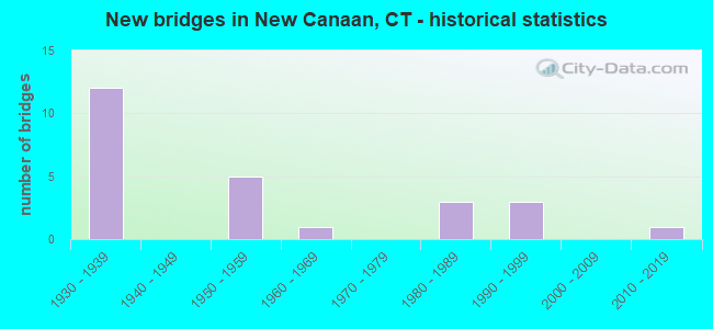
- New bridges - historical statistics
- 121930-1939
- 51950-1959
- 11960-1969
- 31980-1989
- 31990-1999
- 12010-2019

- Reconstructed bridges - Historical Statistics
- 11960-1969
- 11970-1979
- 41980-1989
- 11990-1999
- 32000-2009


- Bridge Condition - Deck
- 43.8%Good
- 25.0%Satisfactory
- 31.3%Fair

- Bridge Condition - Superstructure
- 11.1%Very good
- 27.8%Good
- 33.3%Satisfactory
- 27.8%Fair

- Bridge Condition - Substructure
- 55.6%Good
- 38.9%Satisfactory
- 5.6%Fair

- Bridge Condition - Channel
- 8.3%Very good
- 33.3%Good
- 58.3%Satisfactory
Find on map >> Show street view
Structure Number: 581, Location: 2.4 MI NORTH OF ROUTE 34 (Lat: 41.351217, Lng: -73.095225), Route carried "on" structure: State highway 8, Year Built: 1956, Year Reconstructed: 1989, Status: Open, Structure Length: 1.52m (4.99ft), Average Daily Traffic: 63,800 (year 2018), Truck Traffic: 5%, Average Future Daily Traffic: 94,800 (year 2038), Design Load: HS 20, Features Intersected: HULL STREET
Minimum Vertical Clearance: 30+ m (98+ ft), Kilometerpoint: 24.430, Lanes on structure: 4, Lanes under structure: 2, Base Highway Network: Yes, Owner: State Highway Agency, Approaching Roadway Width: 23.5m (77.1ft), Skew: 32 degrees, Material/Design: Steel, Design/Construction: Stringer/Multi-beam, Number Of Spans In Main Unit: 1, Length of Maximum Span: 14.0m (45.9ft), Curb-To-Curb Width: 23.7m (77.8ft), Out-to-Out Width: 25.5m (83.7ft)
Condition: Deck: Good, Superstructure: Satisfactory, Substructure: Good, Operating Rating: 40.2 metric tons, Method Used To Determine Operating Rating: Load and Resistance Factor Rating (LRFR) rating reported by rating factor(RF) method using HL-93 loadings, Inventory Rating: 30.8 metric tons, Method Used To Determine Inventory Rating: Load and Resistance Factor Rating (LRFR) rating reported by rating factor(RF) method using HL-93 loadings, Structural Evaluation: Equal to present minimum criteria, Deck Geometry: Superior to present desirable criteria, Underclear: Somewhat better than minimum adequacy, Approach Roadway Alignment: Equal to present desirable criteria, Designated Inspection Frequency: Every 24 months, Inspection Date: Febuary 2022, Deck Structure Type: Concrete Cast-file-Place, Wearing Surface/Protective System: Wearing Surface: Bituminous, Membrane: Preformed Fabric, Deck Protection: Epoxy Coated Reinforcing
Find on map >> Show street view
Structure Number: 708, Location: 1.0 MI S OF ROUTE 106 (Lat: 41.118986, Lng: -73.517553), Route carried "on" structure: City street , Year Built: 1937, Status: Open, Structure Length: 1.98m (6.50ft), Average Daily Traffic: 2,500 (year 2020), Truck Traffic: 3%, Average Future Daily Traffic: 3,715 (year 2040), Design Load: H 20, Features Intersected: ROUTE 15, Facility Carried by Structure: PONUS RIDGE ROAD
Minimum Vertical Clearance: 30+ m (98+ ft), Kilometerpoint: 0.531, Lanes on structure: 2, Lanes under structure: 4, Owner: State Highway Agency, Approaching Roadway Width: 7.0m (23.0ft), Skew: 1 degrees, Material/Design: Concrete, Design/Construction: Frame, Number Of Spans In Main Unit: 1, Length of Maximum Span: 19.8m (65.0ft), Curb or Sidewalk Widths: Left: 0.3m (1.0ft), Right: 0.3m (1.0ft), Curb-To-Curb Width: 9.1m (29.9ft), Out-to-Out Width: 10.7m (35.1ft)
Condition: Deck: Satisfactory, Superstructure: Satisfactory, Substructure: Satisfactory, Inventory Rating: 81.4 metric tons, Method Used To Determine Inventory Rating: Load Factor (LF), Structural Evaluation: Equal to present minimum criteria, Deck Geometry: Meets minimum limits, Underclear: High priority of corrective action, Approach Roadway Alignment: Equal to present minimum criteria, Designated Inspection Frequency: Every 24 months, Inspection Date: November 2021
Find on map >> Show street view
Structure Number: 709, Location: ROUTE 15 EXIT NO. 36 (Lat: 41.117189, Lng: -73.499344), Route carried "on" structure: State highway 15, Year Built: 1937, Year Reconstructed: 1994, Status: Posted for load-capacity, Structure Length: 1.46m (4.79ft), Average Daily Traffic: 73,500 (year 2015), Truck Traffic: 1%, Average Future Daily Traffic: 109,214 (year 2035), Design Load: H 20, Features Intersected: ROUTE 106
Minimum Vertical Clearance: 30+ m (98+ ft), Kilometerpoint: 21.308, Lanes on structure: 6, Lanes under structure: 4, Base Highway Network: Yes, Owner: State Highway Agency, Approaching Roadway Width: 27.7m (90.9ft), Skew: 30 degrees, Material/Design: Concrete, Design/Construction: Frame, Number Of Spans In Main Unit: 1, Length of Maximum Span: 14.6m (47.9ft), Curb-To-Curb Width: 27.2m (89.2ft), Out-to-Out Width: 29.2m (95.8ft)
Condition: Superstructure: Satisfactory, Substructure: Satisfactory, Operating Rating: 52.6 metric tons, Method Used To Determine Operating Rating: Field evaluation and documented engineering judgment, Inventory Rating: 30.8 metric tons, Method Used To Determine Inventory Rating: Field evaluation and documented engineering judgment, Structural Evaluation: Equal to present minimum criteria, Deck Geometry: Equal to present minimum criteria, Underclear: High priority of corrective action, Approach Roadway Alignment: Equal to present desirable criteria, Designated Inspection Frequency: Every 24 months, Inspection Date: June 2020, Deck Structure Type: Other, Wearing Surface/Protective System: Wearing Surface: Bituminous, Membrane: Preformed Fabric
Find on map >> Show street view
Structure Number: 712, Location: EXIT 37 ROUTE 15 (Lat: 41.119103, Lng: -73.483100), Route carried "on" structure: State highway 124, Year Built: 1937, Year Reconstructed: 1972, Status: Open, Structure Length: 2.37m (7.78ft), Average Daily Traffic: 10,000 (year 2017), Truck Traffic: 6%, Average Future Daily Traffic: 14,859 (year 2037), Design Load: H 20, Features Intersected: ROUTE 15
Minimum Vertical Clearance: 30+ m (98+ ft), Kilometerpoint: 4.957, Lanes on structure: 2, Lanes under structure: 4, Base Highway Network: Yes, Owner: State Highway Agency, Approaching Roadway Width: 13.7m (44.9ft), Skew: 2 degrees, Material/Design: Concrete, Design/Construction: Frame, Number Of Spans In Main Unit: 1, Length of Maximum Span: 20.6m (67.6ft), Curb or Sidewalk Widths: Left: 0.2m (0.7ft), Right: 0.2m (0.7ft), Curb-To-Curb Width: 13.7m (44.9ft), Out-to-Out Width: 16.0m (52.5ft)
Condition: Deck: Fair, Superstructure: Fair, Substructure: Good, Operating Rating: 59.9 metric tons, Method Used To Determine Operating Rating: Load Factor (LF), Inventory Rating: 35.4 metric tons, Method Used To Determine Inventory Rating: Load Factor (LF), Structural Evaluation: Somewhat better than minimum adequacy, Deck Geometry: Superior to present desirable criteria, Underclear: High priority of corrective action, Approach Roadway Alignment: Equal to present minimum criteria, Designated Inspection Frequency: Every 24 months, Inspection Date: March 2021, Deck Structure Type: Concrete Cast-file-Place, Wearing Surface/Protective System: Wearing Surface: Bituminous, Membrane: Built-up
Find on map >> Show street view
Structure Number: 713, Location: OVER ROUTE 15 (Lat: 41.123236, Lng: -73.473661), Route carried "on" structure: City street , Year Built: 1938, Year Reconstructed: 1991, Status: Open, Structure Length: 2.49m (8.17ft), Average Daily Traffic: 3,800 (year 2018), Truck Traffic: 4%, Average Future Daily Traffic: 5,646 (year 2038), Design Load: HS 20, Features Intersected: ROUTE 15, Facility Carried by Structure: WHITE OAK SHADE RD
Minimum Vertical Clearance: 30+ m (98+ ft), Kilometerpoint: 1.625, Lanes on structure: 2, Lanes under structure: 4, Owner: State Highway Agency, Approaching Roadway Width: 9.1m (29.9ft), Skew: 2 degrees, Material/Design: Concrete, Design/Construction: Frame, Number Of Spans In Main Unit: 1, Length of Maximum Span: 20.8m (68.2ft), Curb-To-Curb Width: 9.1m (29.9ft), Out-to-Out Width: 11.1m (36.4ft)
Condition: Superstructure: Fair, Substructure: Fair, Operating Rating: 54.5 metric tons, Method Used To Determine Operating Rating: Load Factor (LF), Inventory Rating: 32.7 metric tons, Method Used To Determine Inventory Rating: Load Factor (LF), Structural Evaluation: Somewhat better than minimum adequacy, Deck Geometry: Meets minimum limits, Underclear: High priority of corrective action, Approach Roadway Alignment: Equal to present desirable criteria, Designated Inspection Frequency: Every 24 months, Inspection Date: July 2020, Deck Structure Type: Concrete Cast-file-Place, Wearing Surface/Protective System: Wearing Surface: Bituminous, Membrane: Preformed Fabric, Deck Protection: Epoxy Coated Reinforcing
Find on map >> Show street view
Structure Number: 917, Location: 0.6 MI FROM NEW YORK S L (Lat: 41.185247, Lng: -73.529806), Route carried "on" structure: State highway 124, Year Built: 1957, Year Reconstructed: 1999, Status: Open, Structure Length: 0.79m (2.59ft), Average Daily Traffic: 4,200 (year 2017), Truck Traffic: 5%, Average Future Daily Traffic: 6,241 (year 2037), Design Load: HS 20, Features Intersected: RIPPOWAM RIVER
Minimum Vertical Clearance: 30+ m (98+ ft), Kilometerpoint: 14.243, Lanes on structure: 2, Owner: State Highway Agency, Approaching Roadway Width: 8.8m (28.9ft), Skew: 1 degrees, Material/Design: Prestressed concrete, Design/Construction: Slab, Number Of Spans In Main Unit: 1, Length of Maximum Span: 7.3m (24.0ft), Curb-To-Curb Width: 12.8m (42.0ft), Out-to-Out Width: 13.9m (45.6ft)
Condition: Deck: Good, Superstructure: Good, Substructure: Satisfactory, Channel: Satisfactory, Operating Rating: 57.0 metric tons, Method Used To Determine Operating Rating: Load and Resistance Factor Rating (LRFR) rating reported by rating factor(RF) method using HL-93 loadings, Inventory Rating: 43.7 metric tons, Method Used To Determine Inventory Rating: Load and Resistance Factor Rating (LRFR) rating reported by rating factor(RF) method using HL-93 loadings, Structural Evaluation: Equal to present minimum criteria, Deck Geometry: Equal to present minimum criteria, Waterway Adequacy: Equal to present minimum criteria, Approach Roadway Alignment: Equal to present desirable criteria, Designated Inspection Frequency: Every 24 months, Inspection Date: May 2020, Deck Structure Type: Other, Wearing Surface/Protective System: Wearing Surface: Bituminous, Membrane: Built-up, Deck Protection: Epoxy Coated Reinforcing
Find on map >> Show street view
Structure Number: 1333, Location: 100' NO OF FOREST ST JCT (Lat: 41.155528, Lng: -73.493447), Route carried "on" structure: State highway 123, Year Built: 1962, Status: Open, Structure Length: 1.07m (3.51ft), Average Daily Traffic: 8,400 (year 2020), Truck Traffic: 6%, Average Future Daily Traffic: 12,482 (year 2040), Design Load: HS 20, Features Intersected: FIVE MILE RIVER
Minimum Vertical Clearance: 30+ m (98+ ft), Kilometerpoint: 8.143, Lanes on structure: 2, Base Highway Network: Yes, Owner: State Highway Agency, Approaching Roadway Width: 12.2m (40.0ft), Skew: 3 degrees, Material/Design: Steel, Design/Construction: Stringer/Multi-beam, Number Of Spans In Main Unit: 1, Length of Maximum Span: 8.5m (27.9ft), Curb or Sidewalk Widths: Left: 1.8m (5.9ft), Right: 1.8m (5.9ft), Curb-To-Curb Width: 12.2m (40.0ft), Out-to-Out Width: 16.5m (54.1ft)
Condition: Deck: Satisfactory, Superstructure: Satisfactory, Substructure: Good, Channel: Satisfactory, Operating Rating: 59.0 metric tons, Method Used To Determine Operating Rating: Load Factor (LF), Inventory Rating: 35.5 metric tons, Method Used To Determine Inventory Rating: Load Factor (LF), Structural Evaluation: Equal to present minimum criteria, Deck Geometry: Somewhat better than minimum adequacy, Waterway Adequacy: Better than present minimum criteria, Approach Roadway Alignment: Equal to present desirable criteria, Designated Inspection Frequency: Every 24 months, Inspection Date: September 2021, Deck Structure Type: Concrete Cast-file-Place, Wearing Surface/Protective System: Wearing Surface: Bituminous, Membrane: Preformed Fabric
Find on map >> Show street view
Structure Number: 2144, Location: 1 MILE SOUTH OF RTE 123 (Lat: 41.124758, Lng: -73.471158), Route carried "on" structure: State highway 15, Year Built: 1937, Year Reconstructed: 1975, Status: Posted for load-capacity, Structure Length: 1.25m (4.10ft), Average Daily Traffic: 72,900 (year 2015), Truck Traffic: 1%, Average Future Daily Traffic: 108,322 (year 2035), Features Intersected: FIVE MILE RIVER
Minimum Vertical Clearance: 30+ m (98+ ft), Kilometerpoint: 23.931, Lanes on structure: 4, Base Highway Network: Yes, Owner: State Highway Agency, Approaching Roadway Width: 15.9m (52.2ft), Skew: 20 degrees, Material/Design: Concrete, Design/Construction: Culvert, Number Of Spans In Main Unit: 3, Length of Maximum Span: 3.4m (11.2ft)
Condition: Channel: Satisfactory, Culverts: Satisfactory, Operating Rating: 42.6 metric tons, Method Used To Determine Operating Rating: Field evaluation and documented engineering judgment, Inventory Rating: 32.7 metric tons, Method Used To Determine Inventory Rating: Field evaluation and documented engineering judgment, Structural Evaluation: Equal to present minimum criteria, Waterway Adequacy: Equal to present minimum criteria, Approach Roadway Alignment: Equal to present desirable criteria, Designated Inspection Frequency: Every 24 months, Inspection Date: January 2020
Find on map >> Show street view
Structure Number: 2647, Location: 0.4 MI NORTH OF ROUTE 106 (Lat: 41.151331, Lng: -73.489467), Route carried "on" structure: State highway 123, Year Built: 1933, Status: Open, Structure Length: 0.70m (2.30ft), Average Daily Traffic: 11,600 (year 2017), Truck Traffic: 6%, Average Future Daily Traffic: 17,236 (year 2037), Design Load: H 20, Features Intersected: FIVE MILE RIVER
Minimum Vertical Clearance: 30+ m (98+ ft), Kilometerpoint: 7.548, Lanes on structure: 2, Base Highway Network: Yes, Owner: State Highway Agency, Approaching Roadway Width: 15.2m (49.9ft), Skew: 4 degrees, Material/Design: Concrete, Design/Construction: Slab, Number Of Spans In Main Unit: 1, Length of Maximum Span: 6.1m (20.0ft), Curb-To-Curb Width: 15.2m (49.9ft), Out-to-Out Width: 16.8m (55.1ft)
Condition: Deck: Fair, Superstructure: Fair, Substructure: Satisfactory, Channel: Satisfactory, Operating Rating: 52.6 metric tons, Method Used To Determine Operating Rating: Field evaluation and documented engineering judgment, Inventory Rating: 30.8 metric tons, Method Used To Determine Inventory Rating: Field evaluation and documented engineering judgment, Structural Evaluation: Somewhat better than minimum adequacy, Deck Geometry: Superior to present desirable criteria, Waterway Adequacy: Equal to present minimum criteria, Approach Roadway Alignment: Equal to present minimum criteria, Designated Inspection Frequency: Every 24 months, Inspection Date: August 2020, Deck Structure Type: Concrete Cast-file-Place, Wearing Surface/Protective System: Wearing Surface: Bituminous
Find on map >> Show street view
Structure Number: 4095, Location: 100' EAST OF MAIN STREET (Lat: 41.136583, Lng: -73.479356), Route carried "on" structure: City street , Year Built: 1956, Year Reconstructed: 2011, Status: Open, Structure Length: 1.45m (4.76ft), Average Daily Traffic: 3,600 (year 2017), Truck Traffic: 4%, Average Future Daily Traffic: 5,349 (year 2037), Design Load: HL 93, Features Intersected: FIVE MILE RIVER, Facility Carried by Structure: OLD NORWALK ROAD
Minimum Vertical Clearance: 30+ m (98+ ft), Kilometerpoint: 0.000, Lanes on structure: 2, Owner: Town or Township Highway Agency, Approaching Roadway Width: 9.4m (30.8ft), Skew: 1 degrees, Material/Design: Steel, Design/Construction: Stringer/Multi-beam, Number Of Spans In Main Unit: 1, Length of Maximum Span: 13.1m (43.0ft), Curb or Sidewalk Widths: Left: 0.0m, Right: 1.5m (4.9ft), Curb-To-Curb Width: 9.4m (30.8ft), Out-to-Out Width: 11.9m (39.0ft)
Condition: Deck: Good, Superstructure: Very good, Substructure: Good, Channel: Satisfactory, Operating Rating: 81.3 metric tons, Method Used To Determine Operating Rating: Load and Resistance Factor Rating (LRFR) rating reported by rating factor(RF) method using HL-93 loadings, Inventory Rating: 62.5 metric tons, Method Used To Determine Inventory Rating: Load and Resistance Factor Rating (LRFR) rating reported by rating factor(RF) method using HL-93 loadings, Structural Evaluation: Better than present minimum criteria, Deck Geometry: Meets minimum limits, Waterway Adequacy: Superior to present desirable criteria, Approach Roadway Alignment: Equal to present desirable criteria, Designated Inspection Frequency: Every 24 months, Inspection Date: January 2021, Deck Structure Type: Concrete Cast-file-Place, Wearing Surface/Protective System: Wearing Surface: Bituminous, Membrane: Built-up, Deck Protection: Epoxy Coated Reinforcing
Find on map >> Show street view
Structure Number: 4963, Location: 500' WEST OF VALLEY ROAD (Lat: 41.198611, Lng: -73.492567), Route carried "on" structure: City street , Year Built: 1956, Year Reconstructed: 2000, Status: Open, Structure Length: 1.46m (4.79ft), Average Daily Traffic: 1,400 (year 2017), Truck Traffic: 2%, Average Future Daily Traffic: 2,080 (year 2037), Design Load: HS 20, Features Intersected: SILVERMINE RIVER, Facility Carried by Structure: NORTH WILTON ROAD
Minimum Vertical Clearance: 30+ m (98+ ft), Kilometerpoint: 0.000, Lanes on structure: 2, Owner: Town or Township Highway Agency, Approaching Roadway Width: 8.5m (27.9ft), Material/Design: Prestressed concrete, Design/Construction: Box Beam or Girders - Multiple, Number Of Spans In Main Unit: 1, Length of Maximum Span: 13.4m (44.0ft), Curb-To-Curb Width: 8.5m (27.9ft), Out-to-Out Width: 9.6m (31.5ft)
Condition: Deck: Satisfactory, Superstructure: Satisfactory, Substructure: Good, Channel: Good, Operating Rating: 68.7 metric tons, Method Used To Determine Operating Rating: Load Factor (LF), Inventory Rating: 41.2 metric tons, Method Used To Determine Inventory Rating: Load Factor (LF), Structural Evaluation: Equal to present minimum criteria, Deck Geometry: Somewhat better than minimum adequacy, Waterway Adequacy: Better than present minimum criteria, Approach Roadway Alignment: Equal to present desirable criteria, Designated Inspection Frequency: Every 24 months, Inspection Date: Febuary 2021, Deck Structure Type: Concrete Cast-file-Place, Wearing Surface/Protective System: Wearing Surface: Bituminous, Membrane: Built-up, Deck Protection: Epoxy Coated Reinforcing
Find on map >> Show street view
Structure Number: 5, Location: JCT OF MILL PORT AVENUE (Lat: 41.144756, Lng: -73.484317), Route carried "on" structure: City street , Year Built: 1957, Year Reconstructed: 2008, Status: Open, Structure Length: 1.16m (3.81ft), Average Daily Traffic: 1,200 (year 2021), Truck Traffic: 2%, Average Future Daily Traffic: 1,783 (year 2041), Design Load: HS 20, Features Intersected: FIVE MILE RIVER, Facility Carried by Structure: LAKEVIEW AVENUE
Minimum Vertical Clearance: 30+ m (98+ ft), Kilometerpoint: 0.000, Lanes on structure: 2, Owner: Town or Township Highway Agency, Approaching Roadway Width: 8.2m (26.9ft), Skew: 1 degrees, Material/Design: Steel, Design/Construction: Stringer/Multi-beam, Number Of Spans In Main Unit: 1, Length of Maximum Span: 10.4m (34.1ft), Curb or Sidewalk Widths: Left: 1.7m (5.6ft), Right: 0.0m, Curb-To-Curb Width: 8.6m (28.2ft), Out-to-Out Width: 11.4m (37.4ft)
Condition: Deck: Good, Superstructure: Good, Substructure: Good, Channel: Good, Operating Rating: 82.0 metric tons, Method Used To Determine Operating Rating: Load and Resistance Factor Rating (LRFR) rating reported by rating factor(RF) method using HL-93 loadings, Inventory Rating: 62.9 metric tons, Method Used To Determine Inventory Rating: Load and Resistance Factor Rating (LRFR) rating reported by rating factor(RF) method using HL-93 loadings, Structural Evaluation: Better than present minimum criteria, Deck Geometry: Somewhat better than minimum adequacy, Waterway Adequacy: Superior to present desirable criteria, Approach Roadway Alignment: Equal to present minimum criteria, Designated Inspection Frequency: Every 24 months, Inspection Date: January 2021, Deck Structure Type: Concrete Cast-file-Place, Wearing Surface/Protective System: Wearing Surface: Bituminous, Membrane: Built-up, Deck Protection: Epoxy Coated Reinforcing
Find on map >> Show street view
Structure Number: 5574, Location: 0.1 MI WEST OF ROUTE 106 (Lat: 41.118722, Lng: -73.501311), Route carried "on" structure: City street , Year Built: 2018, Status: Open, Structure Length: 2.32m (7.61ft), Average Daily Traffic: 1,900 (year 2021), Truck Traffic: 7%, Average Future Daily Traffic: 2,823 (year 2041), Design Load: HL 93, Features Intersected: NOROTON RIVER, Facility Carried by Structure: JELLIFF MILL ROAD
Minimum Vertical Clearance: 30+ m (98+ ft), Kilometerpoint: 0.000, Lanes on structure: 2, Owner: Town or Township Highway Agency, Approaching Roadway Width: 8.5m (27.9ft), Skew: 4 degrees, Material/Design: Steel, Design/Construction: Stringer/Multi-beam, Number Of Spans In Main Unit: 1, Length of Maximum Span: 21.0m (68.9ft), Curb-To-Curb Width: 8.5m (27.9ft), Out-to-Out Width: 9.6m (31.5ft)
Condition: Deck: Good, Superstructure: Very good, Substructure: Good, Channel: Very good, Operating Rating: 61.2 metric tons, Method Used To Determine Operating Rating: Load and Resistance Factor Rating (LRFR) rating reported by rating factor(RF) method using HL-93 loadings, Inventory Rating: 47.3 metric tons, Method Used To Determine Inventory Rating: Load and Resistance Factor Rating (LRFR) rating reported by rating factor(RF) method using HL-93 loadings, Structural Evaluation: Better than present minimum criteria, Deck Geometry: Somewhat better than minimum adequacy, Waterway Adequacy: Better than present minimum criteria, Approach Roadway Alignment: Equal to present minimum criteria, Designated Inspection Frequency: Every 24 months, Inspection Date: January 2021, Total Project Cost: $3,496,000, Deck Structure Type: Concrete Cast-file-Place, Wearing Surface/Protective System: Wearing Surface: Bituminous, Membrane: Built-up, Deck Protection: Epoxy Coated Reinforcing
Find on map >> Show street view
Structure Number: 5706, Location: 475 FT S OF ROUTE 123 (Lat: 41.147831, Lng: -73.483503), Route carried "on" structure: State highway 106, Year Built: 1989, Status: Open, Structure Length: 1.25m (4.10ft), Average Daily Traffic: 8,200 (year 2015), Truck Traffic: 3%, Average Future Daily Traffic: 12,184 (year 2035), Design Load: HS 20, Features Intersected: FIVE MILE RIVER
Minimum Vertical Clearance: 30+ m (98+ ft), Kilometerpoint: 11.877, Lanes on structure: 2, Base Highway Network: Yes, Owner: State Highway Agency, Approaching Roadway Width: 9.8m (32.2ft), Skew: 1 degrees, Material/Design: Steel, Design/Construction: Stringer/Multi-beam, Number Of Spans In Main Unit: 1, Length of Maximum Span: 10.7m (35.1ft), Curb or Sidewalk Widths: Left: 1.7m (5.6ft), Right: 0.0m, Curb-To-Curb Width: 9.8m (32.2ft), Out-to-Out Width: 12.4m (40.7ft)
Condition: Deck: Good, Superstructure: Good, Substructure: Good, Channel: Good, Inventory Rating: 98.8 metric tons, Method Used To Determine Inventory Rating: Load Factor (LF), Structural Evaluation: Better than present minimum criteria, Deck Geometry: Meets minimum limits, Waterway Adequacy: Superior to present desirable criteria, Approach Roadway Alignment: Equal to present minimum criteria, Designated Inspection Frequency: Every 48 months, Inspection Date: April 2018, Deck Structure Type: Concrete Cast-file-Place, Wearing Surface/Protective System: Wearing Surface: Bituminous, Membrane: Preformed Fabric, Deck Protection: Epoxy Coated Reinforcing
Find on map >> Show street view
Structure Number: 581, Location: 0.6 MI S OF ROUTE 124 (Lat: 41.116542, Lng: -73.493675), Route carried "on" structure: City street , Year Built: 1937, Year Reconstructed: 1989, Status: Open, Structure Length: 2.07m (6.79ft), Average Daily Traffic: 1,746 (year 2020), Truck Traffic: 4%, Average Future Daily Traffic: 2,594 (year 2040), Design Load: HS 20, Features Intersected: ROUTE 15, Facility Carried by Structure: LAPHAM ROAD
Minimum Vertical Clearance: 30+ m (98+ ft), Kilometerpoint: 0.209, Lanes on structure: 2, Lanes under structure: 4, Owner: State Highway Agency, Approaching Roadway Width: 9.1m (29.9ft), Material/Design: Prestressed concrete, Design/Construction: Box Beam or Girders - Multiple, Number Of Spans In Main Unit: 1, Length of Maximum Span: 19.5m (64.0ft), Curb-To-Curb Width: 9.1m (29.9ft), Out-to-Out Width: 10.6m (34.8ft)
Condition: Deck: Fair, Superstructure: Fair, Substructure: Satisfactory, Operating Rating: 56.1 metric tons, Method Used To Determine Operating Rating: Load and Resistance Factor Rating (LRFR) rating reported by rating factor(RF) method using HL-93 loadings, Inventory Rating: 43.1 metric tons, Method Used To Determine Inventory Rating: Load and Resistance Factor Rating (LRFR) rating reported by rating factor(RF) method using HL-93 loadings, Structural Evaluation: Somewhat better than minimum adequacy, Deck Geometry: Somewhat better than minimum adequacy, Underclear: High priority of corrective action, Approach Roadway Alignment: Equal to present desirable criteria, Designated Inspection Frequency: Every 24 months, Inspection Date: June 2020, Deck Structure Type: Other, Wearing Surface/Protective System: Wearing Surface: Latex Concrete, Deck Protection: Epoxy Coated Reinforcing
Find on map >> Show street view
Structure Number: 5811, Location: 0.3 MI.W.OF NORWALK T.L. (Lat: 41.127042, Lng: -73.467475), Route carried "on" structure: City street , Year Built: 1989, Status: Open, Structure Length: 2.32m (7.61ft), Average Daily Traffic: 3,400 (year 2017), Truck Traffic: 3%, Average Future Daily Traffic: 5,052 (year 2037), Design Load: HS 20, Features Intersected: ROUTE 15, Facility Carried by Structure: MARVIN RIDGE ROAD
Minimum Vertical Clearance: 30+ m (98+ ft), Kilometerpoint: 1.191, Lanes on structure: 2, Lanes under structure: 4, Owner: State Highway Agency, Approaching Roadway Width: 7.9m (25.9ft), Skew: 1 degrees, Material/Design: Prestressed concrete, Design/Construction: Box Beam or Girders - Multiple, Number Of Spans In Main Unit: 1, Length of Maximum Span: 21.6m (70.9ft), Curb-To-Curb Width: 9.1m (29.9ft), Out-to-Out Width: 10.6m (34.8ft)
Condition: Deck: Fair, Superstructure: Fair, Substructure: Satisfactory, Operating Rating: 52.5 metric tons, Method Used To Determine Operating Rating: Load and Resistance Factor Rating (LRFR) rating reported by rating factor(RF) method using HL-93 loadings, Inventory Rating: 40.5 metric tons, Method Used To Determine Inventory Rating: Load and Resistance Factor Rating (LRFR) rating reported by rating factor(RF) method using HL-93 loadings, Structural Evaluation: Somewhat better than minimum adequacy, Deck Geometry: Meets minimum limits, Underclear: High priority of corrective action, Approach Roadway Alignment: Equal to present minimum criteria, Designated Inspection Frequency: Every 24 months, Inspection Date: June 2020, Deck Structure Type: Other, Wearing Surface/Protective System: Wearing Surface: Latex Concrete, Deck Protection: Epoxy Coated Reinforcing
Find on map >> Show street view
Structure Number: 5852, Location: AT STAMFORD TOWN LINE (Lat: 41.164861, Lng: -73.544322), Route carried "on" structure: City street , Year Built: 1990, Status: Open, Structure Length: 1.28m (4.20ft), Average Daily Traffic: 400 (year 2021), Truck Traffic: 1%, Average Future Daily Traffic: 594 (year 2041), Design Load: HS 20, Features Intersected: RIPPOWAM RIVER, Facility Carried by Structure: RESERVOIR LANE
Minimum Vertical Clearance: 30+ m (98+ ft), Kilometerpoint: 0.000, Lanes on structure: 2, Owner: Town or Township Highway Agency, Approaching Roadway Width: 6.7m (22.0ft), Material/Design: Prestressed concrete, Design/Construction: Slab, Number Of Spans In Main Unit: 1, Length of Maximum Span: 11.9m (39.0ft), Curb-To-Curb Width: 6.7m (22.0ft), Out-to-Out Width: 7.9m (25.9ft)
Condition: Deck: Fair, Superstructure: Satisfactory, Substructure: Good, Channel: Satisfactory, Operating Rating: 78.7 metric tons, Method Used To Determine Operating Rating: Load Factor (LF), Inventory Rating: 47.2 metric tons, Method Used To Determine Inventory Rating: Load Factor (LF), Structural Evaluation: Equal to present minimum criteria, Deck Geometry: Meets minimum limits, Waterway Adequacy: Superior to present desirable criteria, Approach Roadway Alignment: Equal to present desirable criteria, Designated Inspection Frequency: Every 24 months, Inspection Date: January 2021, Deck Structure Type: Other, Wearing Surface/Protective System: Wearing Surface: Bituminous, Membrane: Preformed Fabric, Deck Protection: Epoxy Coated Reinforcing
Find on map >> Show street view
Structure Number: 5853, Location: 300'W OF PONUS RIDGE ROAD (Lat: 41.178708, Lng: -73.553756), Route carried "on" structure: City street , Year Built: 1990, Status: Open, Structure Length: 1.28m (4.20ft), Average Daily Traffic: 1,140 (year 2021), Truck Traffic: 1%, Average Future Daily Traffic: 1,694 (year 2041), Design Load: HS 20, Features Intersected: RIPPOWAM RIVER, Facility Carried by Structure: TRINITY PASS ROAD
Minimum Vertical Clearance: 30+ m (98+ ft), Kilometerpoint: 0.000, Lanes on structure: 2, Owner: Town or Township Highway Agency, Approaching Roadway Width: 6.7m (22.0ft), Material/Design: Prestressed concrete, Design/Construction: Slab, Number Of Spans In Main Unit: 1, Length of Maximum Span: 11.9m (39.0ft), Curb or Sidewalk Widths: Left: 0.2m (0.7ft), Right: 0.2m (0.7ft), Curb-To-Curb Width: 6.7m (22.0ft), Out-to-Out Width: 7.9m (25.9ft)
Condition: Deck: Good, Superstructure: Good, Substructure: Good, Channel: Good, Operating Rating: 64.8 metric tons, Method Used To Determine Operating Rating: Load Factor (LF), Inventory Rating: 38.7 metric tons, Method Used To Determine Inventory Rating: Load Factor (LF), Structural Evaluation: Better than present minimum criteria, Deck Geometry: High priority of corrective action, Waterway Adequacy: Superior to present desirable criteria, Approach Roadway Alignment: Better than present minimum criteria, Designated Inspection Frequency: Every 24 months, Inspection Date: January 2021, Deck Structure Type: Other, Wearing Surface/Protective System: Wearing Surface: Bituminous, Membrane: Preformed Fabric, Deck Protection: Epoxy Coated Reinforcing
Find on map >> Show street view
Structure Number: 5874, Location: WILTON - NEW CANAAN TL (Lat: 41.161022, Lng: -73.462669), Route carried "on" structure: State highway 106, Year Built: 1990, Status: Open, Structure Length: 1.31m (4.30ft), Average Daily Traffic: 2,900 (year 2020), Truck Traffic: 5%, Average Future Daily Traffic: 4,309 (year 2040), Design Load: HS 20, Features Intersected: SILVERMINE RIVER
Minimum Vertical Clearance: 30+ m (98+ ft), Kilometerpoint: 14.645, Lanes on structure: 2, Owner: State Highway Agency, Approaching Roadway Width: 9.4m (30.8ft), Skew: 4 degrees, Material/Design: Prestressed concrete, Design/Construction: Slab, Number Of Spans In Main Unit: 1, Length of Maximum Span: 12.8m (42.0ft), Curb-To-Curb Width: 9.8m (32.2ft), Out-to-Out Width: 11.1m (36.4ft)
Condition: Deck: Satisfactory, Superstructure: Good, Substructure: Satisfactory, Channel: Satisfactory, Operating Rating: 53.1 metric tons, Method Used To Determine Operating Rating: Load and Resistance Factor Rating (LRFR) rating reported by rating factor(RF) method using HL-93 loadings, Inventory Rating: 40.8 metric tons, Method Used To Determine Inventory Rating: Load and Resistance Factor Rating (LRFR) rating reported by rating factor(RF) method using HL-93 loadings, Structural Evaluation: Equal to present minimum criteria, Deck Geometry: Meets minimum limits, Waterway Adequacy: Equal to present minimum criteria, Approach Roadway Alignment: Equal to present desirable criteria, Designated Inspection Frequency: Every 24 months, Inspection Date: April 2021, Deck Structure Type: Other, Wearing Surface/Protective System: Wearing Surface: Bituminous, Membrane: Preformed Fabric, Deck Protection: Epoxy Coated Reinforcing
Find on map >> Show street view
Structure Number: 708, Location: 1.0 MI S OF ROUTE 106 (Lat: 41.118986, Lng: -73.517553), Route carried "under" structure: State highway 15, Year Built: 1937, Structure Length: 0. m, Average Daily Traffic: 74,420 (year 2019), Features Intersected: ROUTE 15, Facility Carried by Structure: PONUS RIDGE ROAD
Minimum Vertical Clearance: 4.34m (14.24ft), Kilometerpoint: 19.779, Lanes on structure: 2, Lanes under structure: 4, Material/Design: Concrete, Design/Construction: Frame, Length of Maximum Span: 19.8m (65.0ft)
Find on map >> Show street view
Structure Number: 709, Location: ROUTE 15 EXIT NO. 36 (Lat: 41.117189, Lng: -73.499344), Route carried "under" structure: State highway 106, Year Built: 1937, Structure Length: 0. m, Average Daily Traffic: 12,900 (year 2017), Truck Traffic: 1%, Features Intersected: ROUTE 106, Facility Carried by Structure: ROUTE 15
Minimum Vertical Clearance: 4.60m (15.09ft), Kilometerpoint: 7.274, Lanes on structure: 6, Lanes under structure: 4, Material/Design: Concrete, Design/Construction: Frame, Length of Maximum Span: 14.6m (47.9ft)
Find on map >> Show street view
Structure Number: 712, Location: EXIT 37 ROUTE 15 (Lat: 41.119103, Lng: -73.483100), Route carried "under" structure: State highway 15, Year Built: 1937, Structure Length: 0. m, Average Daily Traffic: 72,900 (year 2017), Truck Traffic: 1%, Features Intersected: ROUTE 15, Facility Carried by Structure: ROUTE 124
Minimum Vertical Clearance: 4.32m (14.17ft), Kilometerpoint: 22.756, Lanes on structure: 2, Lanes under structure: 4, Material/Design: Concrete, Design/Construction: Frame, Length of Maximum Span: 20.6m (67.6ft)
Find on map >> Show street view
Structure Number: 713, Location: OVER ROUTE 15 (Lat: 41.123236, Lng: -73.473661), Route carried "under" structure: State highway 15, Year Built: 1938, Structure Length: 0. m, Average Daily Traffic: 72,900 (year 2018), Truck Traffic: 1%, Features Intersected: ROUTE 15, Facility Carried by Structure: WHITE OAK SHADE RD
Minimum Vertical Clearance: 4.70m (15.42ft), Kilometerpoint: 23.673, Lanes on structure: 2, Lanes under structure: 4, Material/Design: Concrete, Design/Construction: Frame, Length of Maximum Span: 20.8m (68.2ft)
Find on map >> Show street view
Structure Number: 581, Location: 0.6 MI S OF ROUTE 124 (Lat: 41.116542, Lng: -73.493675), Route carried "under" structure: State highway 15, Year Built: 1937, Structure Length: 0. m, Average Daily Traffic: 73,500 (year 2015), Truck Traffic: 1%, Features Intersected: ROUTE 15, Facility Carried by Structure: LAPHAM ROAD
Minimum Vertical Clearance: 4.24m (13.91ft), Kilometerpoint: 21.807, Lanes on structure: 2, Lanes under structure: 4, Material/Design: Prestressed concrete, Design/Construction: Box Beam or Girders - Multiple, Length of Maximum Span: 19.5m (64.0ft)
Find on map >> Show street view
Structure Number: 5811, Location: 0.3 MI.W.OF NORWALK T.L. (Lat: 41.127042, Lng: -73.467475), Route carried "under" structure: State highway 15, Year Built: 1989, Structure Length: 0. m, Average Daily Traffic: 72,900 (year 2015), Features Intersected: ROUTE 15, Facility Carried by Structure: MARVIN RIDGE ROAD
Minimum Vertical Clearance: 4.24m (13.91ft), Kilometerpoint: 24.349, Lanes on structure: 2, Lanes under structure: 4, Material/Design: Prestressed concrete, Design/Construction: Box Beam or Girders - Multiple, Length of Maximum Span: 21.6m (70.9ft)