Bridge Statistics for Narragansett, Rhode Island (RI)
Condition, Traffic, Stress, Structural Evaluation, Project Costs
- National Bridge Inventory (NBI) Statistics
- 13Number of bridges
- 115ft / 34.8mTotal length
- $22,622,000Total costs
- 104,716Total average daily traffic
- 9,246Total average daily truck traffic
- National Bridge Inventory (NBI) Registered Bridges for Narragansett
- No street view available for this location
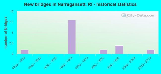
- New bridges - historical statistics
- 11930-1939
- 81960-1969
- 11980-1989
- 21990-1999
- 12010-2019


- Bridge Condition - Deck
- 42.9%Good
- 42.9%Satisfactory
- 14.3%Fair

- Bridge Condition - Superstructure
- 42.9%Good
- 14.3%Satisfactory
- 28.6%Fair
- 14.3%Poor

- Bridge Condition - Substructure
- 57.1%Good
- 28.6%Satisfactory
- 14.3%Fair

- Bridge Condition - Channel
- 20.0%Very good
- 40.0%Satisfactory
- 40.0%Fair
Find on map >> Show street view
Structure Number: 17, Location: 2.6 Mi E of JCT US 1 (Lat: 41.449031, Lng: -71.449783), Route carried "on" structure: US 1A, Year Built: 1981, Status: Open, Structure Length: 4.72m (15.49ft), Average Daily Traffic: 11,818 (year 2021), Truck Traffic: 7%, Average Future Daily Traffic: 13,000 (year 2041), Design Load: HS 20, Features Intersected: NARROW RIVER
Minimum Vertical Clearance: 30+ m (98+ ft), Kilometerpoint: 4.300, Lanes on structure: 2, Base Highway Network: Yes, Owner: State Highway Agency, Approaching Roadway Width: 13.4m (44.0ft), Material/Design: Steel, Design/Construction: Stringer/Multi-beam, Number Of Spans In Main Unit: 1, Length of Maximum Span: 45.7m (149.9ft), Curb or Sidewalk Widths: Left: 1.8m (5.9ft), Right: 1.8m (5.9ft), Curb-To-Curb Width: 13.4m (44.0ft), Out-to-Out Width: 19.1m (62.7ft)
Condition: Deck: Satisfactory, Superstructure: Fair, Substructure: Satisfactory, Channel: Satisfactory, Operating Rating: 56.1 metric tons, Method Used To Determine Operating Rating: Load and Resistance Factor Rating (LRFR) rating reported by rating factor(RF) method using HL-93 loadings, Inventory Rating: 43.1 metric tons, Method Used To Determine Inventory Rating: Load and Resistance Factor Rating (LRFR) rating reported by rating factor(RF) method using HL-93 loadings, Structural Evaluation: Somewhat better than minimum adequacy, Deck Geometry: Equal to present minimum criteria, Waterway Adequacy: Equal to present desirable criteria, Approach Roadway Alignment: Better than present minimum criteria, Length Of Structure Improvement: 4.69m (15.39ft), Designated Inspection Frequency: Every 24 months, Inspection Date: October 2020, Bridge Improvement Cost: $2,874,000, Roadway Improvement Cost: $287,000, Total Project Cost: $4,311,000, Deck Structure Type: Concrete Cast-file-Place, Wearing Surface/Protective System: Wearing Surface: Bituminous, Membrane: Built-up
Find on map >> Show street view
Structure Number: 344, Location: 0.5 Mi W of JCT US 1A (Lat: 41.488292, Lng: -71.447158), Route carried "on" structure: State highway , Year Built: 1934, Status: Open, Structure Length: 1.65m (5.41ft), Average Daily Traffic: 10,491 (year 2021), Truck Traffic: 7%, Average Future Daily Traffic: 11,540 (year 2041), Design Load: H 20, Features Intersected: PETTAQUAMSCUTT RIVER, Facility Carried by Structure: BRIDGETOWN RD
Minimum Vertical Clearance: 30+ m (98+ ft), Kilometerpoint: 1.210, Lanes on structure: 2, Owner: State Highway Agency, Approaching Roadway Width: 12.2m (40.0ft), Skew: 1 degrees, Material/Design: Concrete continuous, Design/Construction: Slab, Number Of Spans In Main Unit: 2, Length of Maximum Span: 7.3m (24.0ft), Curb-To-Curb Width: 12.2m (40.0ft), Out-to-Out Width: 13.4m (44.0ft)
Condition: Deck: Fair, Superstructure: Fair, Substructure: Fair, Channel: Satisfactory, Operating Rating: 81.0 metric tons, Method Used To Determine Operating Rating: Load and Resistance Factor Rating (LRFR) rating reported by rating factor(RF) method using HL-93 loadings, Inventory Rating: 62.5 metric tons, Method Used To Determine Inventory Rating: Load and Resistance Factor Rating (LRFR) rating reported by rating factor(RF) method using HL-93 loadings, Structural Evaluation: Somewhat better than minimum adequacy, Deck Geometry: Somewhat better than minimum adequacy, Waterway Adequacy: Equal to present desirable criteria, Approach Roadway Alignment: Meets minimum limits, Length Of Structure Improvement: 1.62m (5.31ft), Designated Inspection Frequency: Every 24 months, Underwater Inspection Frequency: Every 48 months, Inspection Date: November 2020, Underwater Inspection Date: November 2020, Bridge Improvement Cost: $625,000, Roadway Improvement Cost: $63,000, Total Project Cost: $938,000, Deck Structure Type: Concrete Cast-file-Place, Wearing Surface/Protective System: Wearing Surface: Bituminous, Membrane: Built-up
Find on map >> Show street view
Structure Number: 481, Location: 0.1 Mi N of Scenic 1A (Lat: 41.435003, Lng: -71.482986), Route carried "on" structure: US 1, Year Built: 1962, Year Reconstructed: 2010, Status: Open, Structure Length: 5.46m (17.91ft), Average Daily Traffic: 11,225 (year 2015), Truck Traffic: 2%, Average Future Daily Traffic: 13,470 (year 2036), Design Load: HS 25 or greater, Features Intersected: RI 108 KING RD&PT JDH RD
Minimum Vertical Clearance: 30+ m (98+ ft), Kilometerpoint: 35.285, Lanes on structure: 2, Lanes under structure: 4, Base Highway Network: Yes, Owner: State Highway Agency, Approaching Roadway Width: 11.7m (38.4ft), Skew: 4 degrees, Material/Design: Steel, Design/Construction: Stringer/Multi-beam, Number Of Spans In Main Unit: 3, Length of Maximum Span: 31.3m (102.7ft), Curb-To-Curb Width: 11.7m (38.4ft), Out-to-Out Width: 12.8m (42.0ft)
Condition: Deck: Good, Superstructure: Good, Substructure: Good, Operating Rating: 35.3 metric tons, Method Used To Determine Operating Rating: Load and Resistance Factor Rating (LRFR) rating reported by rating factor(RF) method using HL-93 loadings, Inventory Rating: 27.2 metric tons, Method Used To Determine Inventory Rating: Load and Resistance Factor Rating (LRFR) rating reported by rating factor(RF) method using HL-93 loadings, Structural Evaluation: Equal to present minimum criteria, Deck Geometry: Equal to present minimum criteria, Underclear: High priority of corrective action, Approach Roadway Alignment: Better than present minimum criteria, Length Of Structure Improvement: 5.58m (18.31ft), Designated Inspection Frequency: Every 24 months, Inspection Date: September 2020, Bridge Improvement Cost: $1,463,000, Roadway Improvement Cost: $146,000, Total Project Cost: $2,194,000, Deck Structure Type: Concrete Cast-file-Place, Wearing Surface/Protective System: Wearing Surface: Bituminous, Membrane: Built-up, Deck Protection: Epoxy Coated Reinforcing
Find on map >> Show street view
Structure Number: 4812, Location: 0.1 Mi N of Scenic 1A (Lat: 41.435167, Lng: -71.483086), Route carried "on" structure: US 1, Year Built: 1962, Year Reconstructed: 2010, Status: Open, Structure Length: 5.06m (16.60ft), Average Daily Traffic: 11,225 (year 2008), Truck Traffic: 10%, Average Future Daily Traffic: 13,470 (year 2036), Design Load: HS 25 or greater, Features Intersected: RI 108 KING RD&PT JDH RD
Minimum Vertical Clearance: 30+ m (98+ ft), Kilometerpoint: 12.302, Lanes on structure: 2, Lanes under structure: 4, Base Highway Network: Yes, Owner: State Highway Agency, Approaching Roadway Width: 11.7m (38.4ft), Skew: 4 degrees, Material/Design: Steel, Design/Construction: Stringer/Multi-beam, Number Of Spans In Main Unit: 3, Length of Maximum Span: 28.2m (92.5ft), Curb-To-Curb Width: 11.7m (38.4ft), Out-to-Out Width: 12.8m (42.0ft)
Condition: Deck: Good, Superstructure: Good, Substructure: Good, Operating Rating: 40.8 metric tons, Method Used To Determine Operating Rating: Load and Resistance Factor Rating (LRFR) rating reported by rating factor(RF) method using HL-93 loadings, Inventory Rating: 31.4 metric tons, Method Used To Determine Inventory Rating: Load and Resistance Factor Rating (LRFR) rating reported by rating factor(RF) method using HL-93 loadings, Structural Evaluation: Better than present minimum criteria, Deck Geometry: Equal to present minimum criteria, Underclear: Meets minimum limits, Approach Roadway Alignment: Better than present minimum criteria, Length Of Structure Improvement: 4.18m (13.71ft), Designated Inspection Frequency: Every 24 months, Inspection Date: September 2020, Bridge Improvement Cost: $1,698,000, Roadway Improvement Cost: $170,000, Total Project Cost: $2,547,000, Deck Structure Type: Concrete Cast-file-Place, Wearing Surface/Protective System: Wearing Surface: Bituminous, Membrane: Built-up, Deck Protection: Epoxy Coated Reinforcing
Find on map >> Show street view
Structure Number: 482, Location: 0.3 Mi S of JCT 1A (Lat: 41.432056, Lng: -71.481875), Route carried "on" structure: Ramp US 1, Year Built: 1963, Year Reconstructed: 2010, Status: Open, Structure Length: 4.54m (14.90ft), Average Daily Traffic: 3,400 (year 2015), Truck Traffic: 10%, Average Future Daily Traffic: 4,080 (year 2036), Design Load: HS 20+Mod, Features Intersected: RI 108 POINT JUDITH RD
Minimum Vertical Clearance: 30+ m (98+ ft), Kilometerpoint: 0.171, Lanes on structure: 1, Lanes under structure: 4, Owner: State Highway Agency, Approaching Roadway Width: 6.7m (22.0ft), Skew: 4 degrees, Material/Design: Prestressed concrete, Design/Construction: Stringer/Multi-beam, Number Of Spans In Main Unit: 1, Number Of Approach Spans: 2, Length of Maximum Span: 23.5m (77.1ft), Curb or Sidewalk Widths: Left: 0.6m (2.0ft), Right: 0.6m (2.0ft), Curb-To-Curb Width: 6.7m (22.0ft), Out-to-Out Width: 8.5m (27.9ft)
Condition: Deck: Satisfactory, Superstructure: Poor, Substructure: Satisfactory, Operating Rating: 38.1 metric tons, Method Used To Determine Operating Rating: Load and Resistance Factor (LRFR), Inventory Rating: 29.4 metric tons, Method Used To Determine Inventory Rating: Load and Resistance Factor (LRFR), Structural Evaluation: Meets minimum limits, Deck Geometry: Equal to present minimum criteria, Underclear: High priority of corrective action, Approach Roadway Alignment: Equal to present minimum criteria, Length Of Structure Improvement: 4.66m (15.29ft), Designated Inspection Frequency: Every 24 months, Inspection Date: September 2020, Bridge Improvement Cost: $2,535,000, Roadway Improvement Cost: $254,000, Total Project Cost: $3,803,000, Deck Structure Type: Concrete Cast-file-Place, Wearing Surface/Protective System: Wearing Surface: Bituminous, Membrane: Built-up
Find on map >> Show street view
Structure Number: 483, Location: 0.1 Mi N of JCT RI 108 (Lat: 41.431553, Lng: -71.485172), Route carried "on" structure: Alternate County highway , Year Built: 1963, Status: Open, Structure Length: 5.82m (19.09ft), Average Daily Traffic: 12,625 (year 2014), Truck Traffic: 10%, Average Future Daily Traffic: 15,150 (year 2036), Design Load: HS 20, Features Intersected: US 1 POST RD, Facility Carried by Structure: WOODRUFF AV
Minimum Vertical Clearance: 30+ m (98+ ft), Kilometerpoint: 2.696, Lanes on structure: 2, Lanes under structure: 4, Owner: State Highway Agency, Approaching Roadway Width: 13.4m (44.0ft), Skew: 3 degrees, Material/Design: Prestressed concrete, Design/Construction: Stringer/Multi-beam, Number Of Spans In Main Unit: 2, Number Of Approach Spans: 2, Length of Maximum Span: 18.6m (61.0ft), Curb or Sidewalk Widths: Left: 1.8m (5.9ft), Right: 1.8m (5.9ft), Curb-To-Curb Width: 13.4m (44.0ft), Out-to-Out Width: 17.7m (58.1ft)
Condition: Deck: Satisfactory, Superstructure: Satisfactory, Substructure: Good, Operating Rating: 42.4 metric tons, Method Used To Determine Operating Rating: Load and Resistance Factor Rating (LRFR) rating reported by rating factor(RF) method using HL-93 loadings, Inventory Rating: 32.7 metric tons, Method Used To Determine Inventory Rating: Load and Resistance Factor Rating (LRFR) rating reported by rating factor(RF) method using HL-93 loadings, Structural Evaluation: Equal to present minimum criteria, Deck Geometry: Equal to present minimum criteria, Underclear: Somewhat better than minimum adequacy, Approach Roadway Alignment: Equal to present minimum criteria, Length Of Structure Improvement: 5.73m (18.80ft), Designated Inspection Frequency: Every 24 months, Inspection Date: November 2020, Bridge Improvement Cost: $194,000, Roadway Improvement Cost: $19,000, Total Project Cost: $291,000, Deck Structure Type: Concrete Cast-file-Place, Wearing Surface/Protective System: Wearing Surface: Bituminous, Membrane: Other
Find on map >> Show street view
Structure Number: 4995, Location: 0.1 Mi N of Galilee Rd (Lat: 41.384192, Lng: -71.507275), Route carried "on" structure: City street , Year Built: 2016, Status: Open, Structure Length: 6.23m (20.44ft), Average Daily Traffic: 1,621 (year 2021), Truck Traffic: 8%, Average Future Daily Traffic: 1,783 (year 2041), Design Load: HL 93, Features Intersected: TIDAL FLATS INLET, Facility Carried by Structure: GREAT ISLAND RD
Minimum Vertical Clearance: 30+ m (98+ ft), Kilometerpoint: 0.356, Lanes on structure: 2, Owner: State Highway Agency, Approaching Roadway Width: 9.1m (29.9ft), Skew: 2 degrees, Material/Design: Prestressed concrete, Design/Construction: Box Beam or Girders - Multiple, Number Of Spans In Main Unit: 3, Length of Maximum Span: 25.3m (83.0ft), Curb or Sidewalk Widths: Left: 1.5m (4.9ft), Right: 1.5m (4.9ft), Curb-To-Curb Width: 9.1m (29.9ft), Out-to-Out Width: 13.7m (44.9ft)
Condition: Deck: Good, Superstructure: Good, Substructure: Good, Channel: Very good, Operating Rating: 69.0 metric tons, Method Used To Determine Operating Rating: Load and Resistance Factor Rating (LRFR) rating reported by rating factor(RF) method using HL-93 loadings, Inventory Rating: 53.1 metric tons, Method Used To Determine Inventory Rating: Load and Resistance Factor Rating (LRFR) rating reported by rating factor(RF) method using HL-93 loadings, Structural Evaluation: Better than present minimum criteria, Deck Geometry: Somewhat better than minimum adequacy, Waterway Adequacy: Equal to present desirable criteria, Approach Roadway Alignment: Equal to present desirable criteria, Length Of Structure Improvement: 6.23m (20.44ft), Designated Inspection Frequency: Every 24 months, Underwater Inspection Frequency: Every 48 months, Inspection Date: October 2021, Underwater Inspection Date: October 2021, Bridge Improvement Cost: $6,830,000, Roadway Improvement Cost: $1,708,000, Total Project Cost: $8,538,000 ( Estimate for 2014), Deck Structure Type: Concrete Cast-file-Place, Wearing Surface/Protective System: Wearing Surface: Bituminous, Membrane: Preformed Fabric, Deck Protection: Galvanized Reinforcing
Find on map >> Show street view
Structure Number: 1025, Location: .88Mi west of Rt 108 (Lat: 41.380614, Lng: -71.505225), Route carried "on" structure: Bypass County highway , Year Built: 1992, Status: Open, Structure Length: 0.67m (2.20ft), Average Daily Traffic: 5,411 (year 2021), Truck Traffic: 4%, Average Future Daily Traffic: 5,952 (year 2041), Design Load: HS 20, Features Intersected: POINT JUDITH POND, Facility Carried by Structure: GALILEE ESCAPE RD
Minimum Vertical Clearance: 30+ m (98+ ft), Kilometerpoint: 0.317, Lanes on structure: 4, Base Highway Network: Yes, Owner: State Highway Agency, Approaching Roadway Width: 21.3m (69.9ft), Skew: 10 degrees, Material/Design: Concrete, Design/Construction: Culvert, Number Of Spans In Main Unit: 2, Length of Maximum Span: 3.0m (9.8ft), Curb or Sidewalk Widths: Left: 1.5m (4.9ft), Right: 0.0m, Curb-To-Curb Width: 21.3m (69.9ft), Out-to-Out Width: 21.3m (69.9ft)
Condition: Channel: Fair, Culverts: Good, Operating Rating: 52.8 metric tons, Method Used To Determine Operating Rating: Load and Resistance Factor Rating (LRFR) rating reported by rating factor(RF) method using HL-93 loadings, Inventory Rating: 40.8 metric tons, Method Used To Determine Inventory Rating: Load and Resistance Factor Rating (LRFR) rating reported by rating factor(RF) method using HL-93 loadings, Structural Evaluation: Better than present minimum criteria, Deck Geometry: Superior to present desirable criteria, Waterway Adequacy: Superior to present desirable criteria, Approach Roadway Alignment: Equal to present desirable criteria, Designated Inspection Frequency: Every 24 months, Inspection Date: October 2020
Find on map >> Show street view
Structure Number: 1026, Location: .55 mi west of rt 108 (Lat: 41.379575, Lng: -71.498975), Route carried "on" structure: Bypass County highway , Year Built: 1992, Status: Open, Structure Length: 0.67m (2.20ft), Average Daily Traffic: 3,900 (year 2021), Truck Traffic: 28%, Average Future Daily Traffic: 4,290 (year 2041), Design Load: HS 20, Features Intersected: POINT JUDITH POND, Facility Carried by Structure: GALILEE ESCAPE RD
Minimum Vertical Clearance: 30+ m (98+ ft), Kilometerpoint: 0.853, Lanes on structure: 4, Base Highway Network: Yes, Owner: State Highway Agency, Approaching Roadway Width: 21.3m (69.9ft), Skew: 10 degrees, Material/Design: Concrete, Design/Construction: Culvert, Number Of Spans In Main Unit: 2, Length of Maximum Span: 3.0m (9.8ft), Curb or Sidewalk Widths: Left: 1.5m (4.9ft), Right: 0.0m, Out-to-Out Width: 21.3m (69.9ft)
Condition: Channel: Fair, Culverts: Good, Operating Rating: 52.8 metric tons, Method Used To Determine Operating Rating: Load and Resistance Factor Rating (LRFR) rating reported by rating factor(RF) method using HL-93 loadings, Inventory Rating: 40.8 metric tons, Method Used To Determine Inventory Rating: Load and Resistance Factor Rating (LRFR) rating reported by rating factor(RF) method using HL-93 loadings, Structural Evaluation: Better than present minimum criteria, Waterway Adequacy: Superior to present desirable criteria, Approach Roadway Alignment: Equal to present desirable criteria, Designated Inspection Frequency: Every 24 months, Inspection Date: October 2020
Find on map >> Show street view
Structure Number: 481, Location: 0.1 Mi N of Scenic 1A (Lat: 41.435003, Lng: -71.482986), Route carried "under" structure: Alternate State highway 108, Year Built: 1962, Structure Length: 0. m, Average Daily Traffic: 6,500 (year 2008), Truck Traffic: 10%, Features Intersected: RI 108 KING RD&PT JDH RD, Facility Carried by Structure: US 1 NB POST RD
Minimum Vertical Clearance: 4.36m (14.30ft), Kilometerpoint: 0.000, Lanes on structure: 2, Lanes under structure: 4, Material/Design: Steel, Design/Construction: Stringer/Multi-beam, Length of Maximum Span: 31.3m (102.7ft)
Find on map >> Show street view
Structure Number: 4812, Location: 0.1 Mi N of Scenic 1A (Lat: 41.435167, Lng: -71.483086), Route carried "under" structure: Alternate State highway 108, Year Built: 1962, Structure Length: 0. m, Average Daily Traffic: 6,500 (year 2008), Truck Traffic: 10%, Features Intersected: RI 108 KING RD&PT JDH RD, Facility Carried by Structure: US 1 SB POST RD
Minimum Vertical Clearance: 4.57m (14.99ft), Kilometerpoint: 0.000, Lanes on structure: 2, Lanes under structure: 4, Material/Design: Steel, Design/Construction: Stringer/Multi-beam, Length of Maximum Span: 28.2m (92.5ft)
Find on map >> Show street view
Structure Number: 482, Location: 0.3 Mi S of JCT 1A (Lat: 41.432056, Lng: -71.481875), Route carried "under" structure: State highway 108, Year Built: 1963, Structure Length: 0. m, Average Daily Traffic: 10,000 (year 2008), Truck Traffic: 10%, Features Intersected: RI 108 POINT JUDITH RD, Facility Carried by Structure: US 1 POST RD RAMP
Minimum Vertical Clearance: 4.29m (14.07ft), Kilometerpoint: 0.000, Lanes on structure: 1, Lanes under structure: 3, Material/Design: Prestressed concrete, Design/Construction: Stringer/Multi-beam, Length of Maximum Span: 23.5m (77.1ft)
Find on map >> Show street view
Structure Number: 483, Location: 0.1 Mi N of JCT RI 108 (Lat: 41.431553, Lng: -71.485172), Route carried "under" structure: US 1, Year Built: 1963, Structure Length: 0. m, Average Daily Traffic: 10,000 (year 2008), Truck Traffic: 10%, Features Intersected: US 1 POST RD, Facility Carried by Structure: WOODRUFF AV
Minimum Vertical Clearance: 4.55m (14.93ft), Kilometerpoint: 0.000, Lanes on structure: 2, Lanes under structure: 4, Material/Design: Prestressed concrete, Design/Construction: Stringer/Multi-beam, Length of Maximum Span: 18.6m (61.0ft)