Bridge Statistics for Naples, Texas (TX)
Condition, Traffic, Stress, Structural Evaluation, Project Costs
- National Bridge Inventory (NBI) Statistics
- 15Number of bridges
- 282ft / 86.1mTotal length
- 12,303Total average daily traffic
- 1,630Total average daily truck traffic
- National Bridge Inventory (NBI) Registered Bridges for Naples
- No street view available for this location
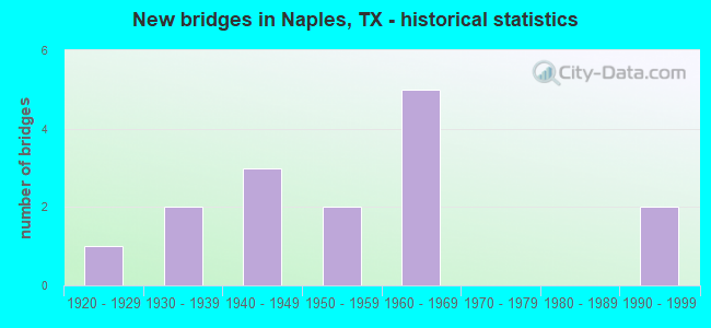
- New bridges - historical statistics
- 11920-1929
- 21930-1939
- 31940-1949
- 21950-1959
- 51960-1969
- 21990-1999


- Bridge Condition - Deck
- 42.9%Good
- 57.1%Satisfactory

- Bridge Condition - Superstructure
- 28.6%Good
- 71.4%Satisfactory

- Bridge Condition - Substructure
- 28.6%Good
- 28.6%Satisfactory
- 42.9%Fair

- Bridge Condition - Channel
- 23.1%Good
- 46.2%Satisfactory
- 30.8%Fair
Find on map >> Show street view
Structure Number: 19019000101108, Location: AT SULPHUR RIVER (Lat: 33.252181, Lng: -94.623147), Route carried "on" structure: US 67, Year Built: 1942, Status: Open, Structure Length: 38.86m (127.49ft), Average Daily Traffic: 708 (year 2020), Truck Traffic: 15%, Average Future Daily Traffic: 1,580 (year 2033), Design Load: H 15, Features Intersected: SULPHUR RIVER
Minimum Vertical Clearance: 30+ m (98+ ft), Kilometerpoint: 25.206, Lanes on structure: 2, Owner: State Highway Agency, Approaching Roadway Width: 7.6m (24.9ft), Material/Design: Steel continuous, Design/Construction: Stringer/Multi-beam, Number Of Spans In Main Unit: 3, Number Of Approach Spans: 27, Length of Maximum Span: 22.9m (75.1ft), Curb-To-Curb Width: 7.7m (25.3ft), Out-to-Out Width: 9.5m (31.2ft)
Condition: Deck: Satisfactory, Superstructure: Satisfactory, Substructure: Fair, Channel: Satisfactory, Operating Rating: 41.7 metric tons, Method Used To Determine Operating Rating: Load Factor (LF), Inventory Rating: 24.5 metric tons, Method Used To Determine Inventory Rating: Load Factor (LF), Structural Evaluation: Somewhat better than minimum adequacy, Deck Geometry: Meets minimum limits, Waterway Adequacy: Equal to present minimum criteria, Approach Roadway Alignment: Equal to present desirable criteria, Designated Inspection Frequency: Every 24 months, Underwater Inspection Frequency: Every 60 months, Inspection Date: June 2020, Underwater Inspection Date: Febuary 2017, Deck Structure Type: Concrete Cast-file-Place, Wearing Surface/Protective System: Wearing Surface: Bituminous
Find on map >> Show street view
Structure Number: 190340001010079, Location: 3.60 MI NE OF SH 77 (Lat: 33.246464, Lng: -94.631106), Route carried "on" structure: US 67, Year Built: 1941, Status: Temporarily open, Structure Length: 24.38m (79.99ft), Average Daily Traffic: 953 (year 2020), Truck Traffic: 14%, Average Future Daily Traffic: 1,510 (year 2033), Design Load: H 15, Features Intersected: JENNINGS SLOUGH
Minimum Vertical Clearance: 30+ m (98+ ft), Kilometerpoint: 0.492, Lanes on structure: 2, Owner: State Highway Agency, Approaching Roadway Width: 13.4m (44.0ft), Material/Design: Steel, Design/Construction: Stringer/Multi-beam, Number Of Spans In Main Unit: 20, Length of Maximum Span: 12.2m (40.0ft), Curb-To-Curb Width: 7.6m (24.9ft), Out-to-Out Width: 9.5m (31.2ft)
Condition: Deck: Good, Superstructure: Satisfactory, Substructure: Fair, Channel: Good, Operating Rating: 46.3 metric tons, Method Used To Determine Operating Rating: Load Factor (LF), Inventory Rating: 27.2 metric tons, Method Used To Determine Inventory Rating: Load Factor (LF), Structural Evaluation: Somewhat better than minimum adequacy, Deck Geometry: Meets minimum limits, Waterway Adequacy: Superior to present desirable criteria, Approach Roadway Alignment: Equal to present desirable criteria, Designated Inspection Frequency: Every 24 months, Inspection Date: July 2020, Deck Structure Type: Concrete Cast-file-Place, Wearing Surface/Protective System: Wearing Surface: Bituminous
Find on map >> Show street view
Structure Number: 190340157402001, Location: 0.0 MI SE OF MORRIS C/L (Lat: 33.153522, Lng: -94.652369), Route carried "on" structure: State highway 161, Year Built: 1953, Status: Open, Structure Length: 1.55m (5.09ft), Average Daily Traffic: 278 (year 2020), Truck Traffic: 17%, Average Future Daily Traffic: 490 (year 2033), Features Intersected: FLOYD CREEK
Minimum Vertical Clearance: 30+ m (98+ ft), Kilometerpoint: 0.005, Lanes on structure: 2, Owner: State Highway Agency, Approaching Roadway Width: 6.1m (20.0ft), Material/Design: Concrete, Design/Construction: Culvert, Number Of Spans In Main Unit: 6, Length of Maximum Span: 2.4m (7.9ft), Curb-To-Curb Width: 6.1m (20.0ft), Out-to-Out Width: 8.3m (27.2ft)
Condition: Channel: Satisfactory, Culverts: Satisfactory, Operating Rating: 39.9 metric tons, Method Used To Determine Operating Rating: Load Factor (LF), Inventory Rating: 23.6 metric tons, Method Used To Determine Inventory Rating: Load Factor (LF), Structural Evaluation: Equal to present minimum criteria, Deck Geometry: Meets minimum limits, Waterway Adequacy: Better than present minimum criteria, Approach Roadway Alignment: Somewhat better than minimum adequacy, Designated Inspection Frequency: Every 24 months, Inspection Date: September 2020, Deck Structure Type: Concrete Cast-file-Place, Wearing Surface/Protective System: Wearing Surface: Bituminous
Find on map >> Show street view
Structure Number: 190340157402002, Location: 0.10 MI SE OF MORRIS C/L (Lat: 33.152331, Lng: -94.651778), Route carried "on" structure: State highway 161, Year Built: 1953, Status: Open, Structure Length: 1.31m (4.30ft), Average Daily Traffic: 278 (year 2020), Truck Traffic: 17%, Average Future Daily Traffic: 490 (year 2033), Features Intersected: WATSON CREEK
Minimum Vertical Clearance: 30+ m (98+ ft), Kilometerpoint: 0.208, Lanes on structure: 2, Owner: State Highway Agency, Approaching Roadway Width: 6.1m (20.0ft), Material/Design: Concrete, Design/Construction: Culvert, Number Of Spans In Main Unit: 5, Length of Maximum Span: 2.4m (7.9ft), Curb-To-Curb Width: 6.1m (20.0ft), Out-to-Out Width: 8.9m (29.2ft)
Condition: Channel: Satisfactory, Culverts: Satisfactory, Operating Rating: 39.9 metric tons, Method Used To Determine Operating Rating: Load Factor (LF), Inventory Rating: 23.6 metric tons, Method Used To Determine Inventory Rating: Load Factor (LF), Structural Evaluation: Equal to present minimum criteria, Deck Geometry: Meets minimum limits, Waterway Adequacy: Better than present minimum criteria, Approach Roadway Alignment: Meets minimum limits, Designated Inspection Frequency: Every 24 months, Inspection Date: September 2020, Deck Structure Type: Concrete Cast-file-Place, Wearing Surface/Protective System: Wearing Surface: Bituminous
Find on map >> Show street view
Structure Number: 190340291901001, Location: 2.20 MI SE OF SH 77 (Lat: 33.177111, Lng: -94.634972), Route carried "on" structure: State highway 2888, Year Built: 1965, Status: Open, Structure Length: 1.07m (3.51ft), Average Daily Traffic: 235 (year 2020), Truck Traffic: 16%, Average Future Daily Traffic: 340 (year 2033), Design Load: HS 20, Features Intersected: DRAW
Minimum Vertical Clearance: 30+ m (98+ ft), Kilometerpoint: 3.557, Lanes on structure: 2, Owner: State Highway Agency, Approaching Roadway Width: 7.9m (25.9ft), Material/Design: Concrete, Design/Construction: Culvert, Number Of Spans In Main Unit: 4, Length of Maximum Span: 2.4m (7.9ft), Curb-To-Curb Width: 10.1m (33.1ft), Out-to-Out Width: 10.5m (34.4ft)
Condition: Channel: Fair, Culverts: Satisfactory, Operating Rating: 39.9 metric tons, Method Used To Determine Operating Rating: Load Factor (LF), Inventory Rating: 23.6 metric tons, Method Used To Determine Inventory Rating: Load Factor (LF), Structural Evaluation: Equal to present minimum criteria, Deck Geometry: Better than present minimum criteria, Waterway Adequacy: Better than present minimum criteria, Approach Roadway Alignment: Equal to present desirable criteria, Designated Inspection Frequency: Every 24 months, Inspection Date: September 2020, Deck Structure Type: Concrete Cast-file-Place, Wearing Surface/Protective System: Wearing Surface: Bituminous
Find on map >> Show street view
Structure Number: 191720001008063, Location: 2.75 MI W OF FM 144 (Lat: 33.188133, Lng: -94.792869), Route carried "on" structure: US 67, Year Built: 1936, Year Reconstructed: 1965, Status: Open, Structure Length: 1.28m (4.20ft), Average Daily Traffic: 3,078 (year 2020), Truck Traffic: 11%, Average Future Daily Traffic: 4,880 (year 2033), Features Intersected: BOGGY CREEK
Minimum Vertical Clearance: 30+ m (98+ ft), Kilometerpoint: 15.239, Lanes on structure: 4, Owner: State Highway Agency, Approaching Roadway Width: 14.0m (45.9ft), Material/Design: Concrete, Design/Construction: Culvert, Number Of Spans In Main Unit: 4, Length of Maximum Span: 3.0m (9.8ft), Curb-To-Curb Width: 14.5m (47.6ft), Out-to-Out Width: 15.9m (52.2ft)
Condition: Channel: Fair, Culverts: Satisfactory, Operating Rating: 32.7 metric tons, Method Used To Determine Operating Rating: Field evaluation and documented engineering judgment, Inventory Rating: 24.5 metric tons, Method Used To Determine Inventory Rating: Field evaluation and documented engineering judgment, Structural Evaluation: Equal to present minimum criteria, Deck Geometry: High priority of replacement, Waterway Adequacy: Equal to present minimum criteria, Approach Roadway Alignment: Equal to present desirable criteria, Designated Inspection Frequency: Every 24 months, Inspection Date: May 2020, Deck Structure Type: Concrete Cast-file-Place, Wearing Surface/Protective System: Wearing Surface: Bituminous
Find on map >> Show street view
Structure Number: 191720001008137, Location: 0.00 MI NW OF US 67 (Lat: 33.209303, Lng: -94.673000), Route carried "on" structure: State highway 77, Year Built: 1969, Status: Open, Structure Length: 10.82m (35.50ft), Average Daily Traffic: 530 (year 2013), Truck Traffic: 15%, Average Future Daily Traffic: 740 (year 2033), Design Load: H 20, Features Intersected: US 67 JOHNSON ST UPRR
Minimum Vertical Clearance: 30+ m (98+ ft), Kilometerpoint: 7.590, Lanes on structure: 2, Lanes under structure: 6, Owner: State Highway Agency, Approaching Roadway Width: 13.4m (44.0ft), Material/Design: Prestressed concrete, Design/Construction: Stringer/Multi-beam, Number Of Spans In Main Unit: 7, Length of Maximum Span: 18.3m (60.0ft), Curb-To-Curb Width: 13.3m (43.6ft), Out-to-Out Width: 13.9m (45.6ft)
Condition: Deck: Good, Superstructure: Good, Substructure: Good, Operating Rating: 53.5 metric tons, Method Used To Determine Operating Rating: Load Factor (LF), Inventory Rating: 29.0 metric tons, Method Used To Determine Inventory Rating: Load Factor (LF), Structural Evaluation: Better than present minimum criteria, Deck Geometry: Superior to present desirable criteria, Underclear: Somewhat better than minimum adequacy, Approach Roadway Alignment: Equal to present desirable criteria, Designated Inspection Frequency: Every 24 months, Inspection Date: May 2020, Deck Structure Type: Concrete Cast-file-Place, Wearing Surface/Protective System: Wearing Surface: Bituminous
Find on map >> Show street view
Structure Number: 191720001008147, Location: 1.00 MI NE OF SH 77 (Lat: 33.222156, Lng: -94.663367), Route carried "on" structure: US 67, Year Built: 1942, Status: Open, Structure Length: 0.88m (2.89ft), Average Daily Traffic: 916 (year 2020), Truck Traffic: 15%, Average Future Daily Traffic: 1,550 (year 2033), Features Intersected: CANEY CREEK
Minimum Vertical Clearance: 30+ m (98+ ft), Kilometerpoint: 0.972, Lanes on structure: 2, Owner: State Highway Agency, Approaching Roadway Width: 12.8m (42.0ft), Skew: 3 degrees, Material/Design: Concrete, Design/Construction: Culvert, Number Of Spans In Main Unit: 3, Length of Maximum Span: 2.4m (7.9ft), Curb-To-Curb Width: 12.7m (41.7ft), Out-to-Out Width: 14.4m (47.2ft)
Condition: Channel: Satisfactory, Culverts: Satisfactory, Operating Rating: 32.7 metric tons, Method Used To Determine Operating Rating: Field evaluation and documented engineering judgment, Inventory Rating: 24.5 metric tons, Method Used To Determine Inventory Rating: Field evaluation and documented engineering judgment, Structural Evaluation: Equal to present minimum criteria, Deck Geometry: Superior to present desirable criteria, Waterway Adequacy: Equal to present minimum criteria, Approach Roadway Alignment: Equal to present desirable criteria, Designated Inspection Frequency: Every 24 months, Inspection Date: May 2020, Deck Structure Type: Concrete Cast-file-Place, Wearing Surface/Protective System: Wearing Surface: Bituminous
Find on map >> Show street view
Structure Number: 191720062201003, Location: 0.50 MI S OF FM 161 (Lat: 33.179322, Lng: -94.675539), Route carried "on" structure: State highway 338, Year Built: 1962, Status: Open, Structure Length: 0.64m (2.10ft), Average Daily Traffic: 1,372 (year 2020), Truck Traffic: 14%, Average Future Daily Traffic: 1,900 (year 2033), Design Load: HS 20, Features Intersected: GIN CREEK
Minimum Vertical Clearance: 30+ m (98+ ft), Kilometerpoint: 19.262, Lanes on structure: 4, Owner: State Highway Agency, Approaching Roadway Width: 15.9m (52.2ft), Material/Design: Concrete, Design/Construction: Culvert, Number Of Spans In Main Unit: 2, Length of Maximum Span: 3.0m (9.8ft), Curb-To-Curb Width: 15.9m (52.2ft), Out-to-Out Width: 23.0m (75.5ft)
Condition: Channel: Satisfactory, Culverts: Satisfactory, Operating Rating: 39.9 metric tons, Method Used To Determine Operating Rating: Load Factor (LF), Inventory Rating: 23.6 metric tons, Method Used To Determine Inventory Rating: Load Factor (LF), Structural Evaluation: Equal to present minimum criteria, Deck Geometry: Meets minimum limits, Waterway Adequacy: Equal to present minimum criteria, Approach Roadway Alignment: Equal to present desirable criteria, Designated Inspection Frequency: Every 24 months, Inspection Date: July 2020, Deck Structure Type: Concrete Cast-file-Place, Wearing Surface/Protective System: Wearing Surface: Bituminous
Find on map >> Show street view
Structure Number: 191720062201004, Location: 2.20 MI S OF FM 161 (Lat: 33.156286, Lng: -94.686008), Route carried "on" structure: State highway 338, Year Built: 1964, Status: Open, Structure Length: 0.73m (2.40ft), Average Daily Traffic: 1,372 (year 2020), Truck Traffic: 14%, Average Future Daily Traffic: 1,900 (year 2033), Design Load: HS 20, Features Intersected: WATSON CREEK
Minimum Vertical Clearance: 30+ m (98+ ft), Kilometerpoint: 21.993, Lanes on structure: 2, Owner: State Highway Agency, Approaching Roadway Width: 8.5m (27.9ft), Skew: 3 degrees, Material/Design: Concrete, Design/Construction: Culvert, Number Of Spans In Main Unit: 2, Length of Maximum Span: 3.7m (12.1ft)
Condition: Channel: Good, Culverts: Satisfactory, Operating Rating: 39.9 metric tons, Method Used To Determine Operating Rating: Load Factor (LF), Inventory Rating: 23.6 metric tons, Method Used To Determine Inventory Rating: Load Factor (LF), Structural Evaluation: Equal to present minimum criteria, Waterway Adequacy: Equal to present minimum criteria, Approach Roadway Alignment: Equal to present desirable criteria, Designated Inspection Frequency: Every 24 months, Inspection Date: July 2020
Find on map >> Show street view
Structure Number: 191720AA0148001, Location: 0.5 MI NE OF US 67 (Lat: 33.222872, Lng: -94.668344), Route carried "on" structure: County highway 4321, Year Built: 1933, Status: Posted for load, Structure Length: 1.22m (4.00ft), Average Daily Traffic: 25 (year 2013), Average Future Daily Traffic: 25 (year 2033), Features Intersected: LITTLE CANEY CREEK
Minimum Vertical Clearance: 30+ m (98+ ft), Kilometerpoint: 0.805, Lanes on structure: 1, Owner: County Highway Agency, Approaching Roadway Width: 3.4m (11.2ft), Material/Design: Concrete, Design/Construction: Slab, Number Of Spans In Main Unit: 2, Length of Maximum Span: 6.1m (20.0ft), Curb-To-Curb Width: 5.5m (18.0ft), Out-to-Out Width: 6.3m (20.7ft)
Condition: Deck: Satisfactory, Superstructure: Satisfactory, Substructure: Fair, Channel: Fair, Operating Rating: 32.7 metric tons, Method Used To Determine Operating Rating: Field evaluation and documented engineering judgment, Inventory Rating: 24.5 metric tons, Method Used To Determine Inventory Rating: Field evaluation and documented engineering judgment, Structural Evaluation: Somewhat better than minimum adequacy, Deck Geometry: Meets minimum limits, Waterway Adequacy: Better than present minimum criteria, Approach Roadway Alignment: Equal to present desirable criteria, Bridge Posting: Required (Relationship of Operating Rating to Maximum Legal Load: > 39.9% below), Designated Inspection Frequency: Every 24 months, Inspection Date: August 2020, Deck Structure Type: Concrete Cast-file-Place, Wearing Surface/Protective System: Wearing Surface: Bituminous
Find on map >> Show street view
Structure Number: 191720AA0148002, Location: 1.3 MI NE OF US 67 (Lat: 33.232819, Lng: -94.661631), Route carried "on" structure: County highway 4321, Year Built: 1925, Status: Open, Structure Length: 1.22m (4.00ft), Average Daily Traffic: 25 (year 2013), Average Future Daily Traffic: 25 (year 2033), Features Intersected: CANEY CREEK
Minimum Vertical Clearance: 30+ m (98+ ft), Kilometerpoint: 2.092, Lanes on structure: 1, Owner: County Highway Agency, Approaching Roadway Width: 3.7m (12.1ft), Material/Design: Concrete, Design/Construction: Slab, Number Of Spans In Main Unit: 2, Length of Maximum Span: 6.1m (20.0ft), Curb-To-Curb Width: 5.5m (18.0ft), Out-to-Out Width: 6.3m (20.7ft)
Condition: Deck: Good, Superstructure: Good, Substructure: Satisfactory, Channel: Fair, Operating Rating: 32.7 metric tons, Method Used To Determine Operating Rating: Field evaluation and documented engineering judgment, Inventory Rating: 24.5 metric tons, Method Used To Determine Inventory Rating: Field evaluation and documented engineering judgment, Structural Evaluation: Equal to present minimum criteria, Deck Geometry: Meets minimum limits, Waterway Adequacy: Better than present minimum criteria, Approach Roadway Alignment: Equal to present desirable criteria, Designated Inspection Frequency: Every 24 months, Inspection Date: August 2020, Deck Structure Type: Concrete Cast-file-Place, Wearing Surface/Protective System: Wearing Surface: Bituminous
Find on map >> Show street view
Structure Number: 191720AA0170001, Location: 0.3 MI W OF FM 161 (Lat: 33.173533, Lng: -94.665725), Route carried "on" structure: County highway 4304, Year Built: 1991, Status: Open, Structure Length: 1.28m (4.20ft), Average Daily Traffic: 23 (year 2013), Average Future Daily Traffic: 23 (year 2033), Features Intersected: WATSON CREEK TRIBUTARY
Minimum Vertical Clearance: 30+ m (98+ ft), Kilometerpoint: 0.483, Lanes on structure: 1, Owner: County Highway Agency, Approaching Roadway Width: 3.0m (9.8ft), Material/Design: Steel, Number Of Spans In Main Unit: 1, Length of Maximum Span: 11.9m (39.0ft), Curb-To-Curb Width: 5.8m (19.0ft), Out-to-Out Width: 5.8m (19.0ft)
Condition: Deck: Satisfactory, Superstructure: Satisfactory, Substructure: Satisfactory, Channel: Satisfactory, Operating Rating: 32.7 metric tons, Method Used To Determine Operating Rating: Field evaluation and documented engineering judgment, Inventory Rating: 24.5 metric tons, Method Used To Determine Inventory Rating: Field evaluation and documented engineering judgment, Structural Evaluation: Equal to present minimum criteria, Deck Geometry: Meets minimum limits, Waterway Adequacy: Meets minimum limits, Approach Roadway Alignment: Better than present minimum criteria, Designated Inspection Frequency: Every 24 months, Inspection Date: August 2020, Deck Structure Type: Steel plate, Wearing Surface/Protective System: Wearing Surface: Bituminous
Find on map >> Show street view
Structure Number: 191720AA4207001, Location: 1.9 MI S OF SH 338 (Lat: 33.151378, Lng: -94.669067), Route carried "on" structure: County highway 4207, Year Built: 1993, Status: Open, Structure Length: 0.85m (2.79ft), Average Daily Traffic: 30 (year 2013), Average Future Daily Traffic: 30 (year 2033), Features Intersected: WATSON CREEK
Minimum Vertical Clearance: 30+ m (98+ ft), Kilometerpoint: 3.058, Lanes on structure: 1, Owner: County Highway Agency, Approaching Roadway Width: 3.7m (12.1ft), Material/Design: Steel, Design/Construction: Stringer/Multi-beam, Number Of Spans In Main Unit: 1, Length of Maximum Span: 8.2m (26.9ft), Curb-To-Curb Width: 5.5m (18.0ft), Out-to-Out Width: 5.5m (18.0ft)
Condition: Deck: Satisfactory, Superstructure: Satisfactory, Substructure: Good, Channel: Good, Operating Rating: 32.7 metric tons, Method Used To Determine Operating Rating: Field evaluation and documented engineering judgment, Inventory Rating: 24.5 metric tons, Method Used To Determine Inventory Rating: Field evaluation and documented engineering judgment, Structural Evaluation: Equal to present minimum criteria, Deck Geometry: Meets minimum limits, Waterway Adequacy: Meets minimum limits, Approach Roadway Alignment: Better than present minimum criteria, Designated Inspection Frequency: Every 24 months, Inspection Date: August 2020, Deck Structure Type: Steel plate, Wearing Surface/Protective System: Wearing Surface: Bituminous
Structure Number: 191720001008137, Location: 0.00 MI NW OF US 67, Route carried "under" structure: US 67, Year Built: 1969, Structure Length: 0. m, Average Daily Traffic: 2,480 (year 2013), Truck Traffic: 13%, Features Intersected: US 67 JOHNSON ST UPRR, Facility Carried by Structure: SH 77
Minimum Vertical Clearance: 8.10m (26.57ft), Kilometerpoint: 2.700, Material/Design: Prestressed concrete, Design/Construction: Stringer/Multi-beam, Length of Maximum Span: 18.3m (60.0ft)
Minimum Vertical Clearance: 8.10m (26.57ft), Kilometerpoint: 2.700, Material/Design: Prestressed concrete, Design/Construction: Stringer/Multi-beam, Length of Maximum Span: 18.3m (60.0ft)