Bridge Statistics for Murphy, Missouri (MO)
Condition, Traffic, Stress, Structural Evaluation, Project Costs
- National Bridge Inventory (NBI) Statistics
- 16Number of bridges
- 112ft / 34.2mTotal length
- 97,932Total average daily traffic
- 7,637Total average daily truck traffic
- 170,964Total future (year 2040) average daily traffic
- National Bridge Inventory (NBI) Registered Bridges for Murphy
- No street view available for this location
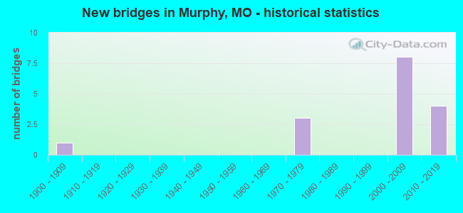
- New bridges - historical statistics
- 11900-1909
- 31970-1979
- 82000-2009
- 42010-2019

- Reconstructed bridges - Historical Statistics
- 31990-1999
- 02000-2009
- 12010-2019


- Bridge Condition - Deck
- 40.0%Good
- 40.0%Satisfactory
- 20.0%Fair

- Bridge Condition - Superstructure
- 50.0%Good
- 30.0%Satisfactory
- 20.0%Fair

- Bridge Condition - Substructure
- 30.0%Very good
- 30.0%Good
- 30.0%Satisfactory
- 10.0%Fair

- Bridge Condition - Channel
- 6.3%Very good
- 37.5%Good
- 43.8%Satisfactory
- 12.5%Fair

- Bridge Condition - Culverts
- 50.0%Good
- 33.3%Satisfactory
- 16.7%Fair
Find on map >> Show street view
Structure Number: 14067, Location: S 301 T 43 N R 5 E (Lat: 38.494350, Lng: -90.467539), Route carried "on" structure: County highway 47, Year Built: 2000, Status: Posted for load, Structure Length: 2.04m (6.69ft), Average Daily Traffic: 4,108 (year 2021), Truck Traffic: 5%, Average Future Daily Traffic: 6,984 (year 2041), Design Load: HS 20, Features Intersected: SALINE CR, Facility Carried by Structure: DELORES DR
Minimum Vertical Clearance: 30+ m (98+ ft), Kilometerpoint: 0.322, Lanes on structure: 2, Owner: County Highway Agency, Approaching Roadway Width: 9.1m (29.9ft), Skew: 3 degrees, Material/Design: Prestressed concrete, Design/Construction: Box Beam or Girders - Multiple, Number Of Spans In Main Unit: 1, Length of Maximum Span: 19.4m (63.6ft), Curb-To-Curb Width: 9.1m (29.9ft), Out-to-Out Width: 9.1m (29.9ft)
Condition: Deck: Good, Superstructure: Good, Substructure: Very good, Channel: Good, Operating Rating: 56.7 metric tons, Method Used To Determine Operating Rating: Load Factor (LF), Inventory Rating: 33.3 metric tons, Method Used To Determine Inventory Rating: Load Factor (LF), Structural Evaluation: Better than present minimum criteria, Deck Geometry: Meets minimum limits, Waterway Adequacy: Superior to present desirable criteria, Approach Roadway Alignment: Equal to present desirable criteria, Designated Inspection Frequency: Every 24 months, Inspection Date: Febuary 2021, Deck Structure Type: Concrete Precast Panels, Wearing Surface/Protective System: Wearing Surface: Bituminous, Membrane: Preformed Fabric, Deck Protection: Other
Find on map >> Show street view
Structure Number: 14178, Location: S 301 T 43 N R 5 E (Lat: 38.491392, Lng: -90.459675), Route carried "on" structure: County highway , Year Built: 1900, Year Reconstructed: 1990, Status: Posted for load, Structure Length: 1.25m (4.10ft), Average Daily Traffic: 3,104 (year 2021), Truck Traffic: 2%, Average Future Daily Traffic: 5,277 (year 2041), Design Load: HS 20, Features Intersected: SALINE CR, Facility Carried by Structure: SALINE RD
Minimum Vertical Clearance: 30+ m (98+ ft), Kilometerpoint: 0.000, Lanes on structure: 2, Owner: County Highway Agency, Approaching Roadway Width: 9.1m (29.9ft), Skew: 2 degrees, Material/Design: Prestressed concrete continuous, Design/Construction: Slab, Number Of Spans In Main Unit: 1, Length of Maximum Span: 11.6m (38.1ft), Curb-To-Curb Width: 9.6m (31.5ft), Out-to-Out Width: 10.0m (32.8ft)
Condition: Deck: Satisfactory, Superstructure: Satisfactory, Substructure: Good, Channel: Satisfactory, Operating Rating: 58.5 metric tons, Method Used To Determine Operating Rating: Allowable Stress (AS), Inventory Rating: 32.4 metric tons, Method Used To Determine Inventory Rating: Allowable Stress (AS), Structural Evaluation: Equal to present minimum criteria, Deck Geometry: Meets minimum limits, Waterway Adequacy: Equal to present desirable criteria, Approach Roadway Alignment: Meets minimum limits, Designated Inspection Frequency: Every 24 months, Inspection Date: Febuary 2021, Deck Structure Type: Concrete Cast-file-Place, Wearing Surface/Protective System: Wearing Surface: Monolithic Concrete
Find on map >> Show street view
Structure Number: 1419, Location: S 16 T 43 N R 5 E (Lat: 38.473933, Lng: -90.467400), Route carried "on" structure: County highway , Year Built: 1970, Year Reconstructed: 1997, Status: Posted for load, Structure Length: 0.94m (3.08ft), Average Daily Traffic: 2,650 (year 2021), Truck Traffic: 5%, Average Future Daily Traffic: 4,505 (year 2041), Design Load: HS 20, Features Intersected: SUGAR CR, Facility Carried by Structure: SALINE RD
Minimum Vertical Clearance: 30+ m (98+ ft), Kilometerpoint: 4.345, Lanes on structure: 2, Owner: County Highway Agency, Approaching Roadway Width: 9.1m (29.9ft), Material/Design: Prestressed concrete, Design/Construction: Box Beam or Girders - Multiple, Number Of Spans In Main Unit: 1, Length of Maximum Span: 9.1m (29.9ft), Curb-To-Curb Width: 8.5m (27.9ft), Out-to-Out Width: 8.5m (27.9ft)
Condition: Deck: Satisfactory, Superstructure: Satisfactory, Substructure: Good, Channel: Fair, Operating Rating: 70.2 metric tons, Method Used To Determine Operating Rating: Load Factor (LF), Inventory Rating: 42.3 metric tons, Method Used To Determine Inventory Rating: Load Factor (LF), Structural Evaluation: Equal to present minimum criteria, Deck Geometry: Meets minimum limits, Waterway Adequacy: Equal to present desirable criteria, Approach Roadway Alignment: Equal to present minimum criteria, Designated Inspection Frequency: Every 24 months, Inspection Date: Febuary 2021, Deck Structure Type: Concrete Precast Panels, Wearing Surface/Protective System: Wearing Surface: Bituminous, Membrane: Preformed Fabric, Deck Protection: Other
Find on map >> Show street view
Structure Number: 15701, Location: S 32 T 44 N R 5 E (Lat: 38.511031, Lng: -90.474506), Route carried "on" structure: County highway , Year Built: 1979, Status: Posted for load, Structure Length: 0.91m (2.99ft), Average Daily Traffic: 7,345 (year 2020), Truck Traffic: 10%, Average Future Daily Traffic: 9,916 (year 2040), Design Load: HS 20, Features Intersected: FENTON CR, Facility Carried by Structure: BOWLES AVE
Minimum Vertical Clearance: 30+ m (98+ ft), Kilometerpoint: 0.000, Lanes on structure: 2, Owner: County Highway Agency, Approaching Roadway Width: 7.6m (24.9ft), Material/Design: Steel, Design/Construction: Culvert, Number Of Spans In Main Unit: 1, Length of Maximum Span: 7.6m (24.9ft), Curb or Sidewalk Widths: Left: 1.2m (3.9ft), Right: 0.0m
Condition: Channel: Satisfactory, Culverts: Fair, Operating Rating: 89.1 metric tons, Method Used To Determine Operating Rating: Allowable Stress (AS), Inventory Rating: 74.7 metric tons, Method Used To Determine Inventory Rating: Allowable Stress (AS), Structural Evaluation: Somewhat better than minimum adequacy, Waterway Adequacy: Equal to present minimum criteria, Approach Roadway Alignment: Better than present minimum criteria, Designated Inspection Frequency: Every 24 months, Inspection Date: March 2021
Find on map >> Show street view
Structure Number: 2331, Location: S 3011 T 47 N R 5 E (Lat: 38.481594, Lng: -90.442378), Route carried "on" structure: State highway 141, Year Built: 1974, Year Reconstructed: 2002, Status: Open, Structure Length: 4.60m (15.09ft), Average Daily Traffic: 14,844 (year 2021), Truck Traffic: 6%, Average Future Daily Traffic: 27,461 (year 2041), Design Load: HS 20, Features Intersected: SALINE CR
Minimum Vertical Clearance: 30+ m (98+ ft), Kilometerpoint: 41.159, Lanes on structure: 2, Base Highway Network: Yes, Owner: State Highway Agency, Approaching Roadway Width: 12.2m (40.0ft), Material/Design: Steel continuous, Design/Construction: Stringer/Multi-beam, Number Of Spans In Main Unit: 3, Length of Maximum Span: 18.0m (59.1ft), Curb-To-Curb Width: 11.6m (38.1ft), Out-to-Out Width: 12.4m (40.7ft)
Condition: Deck: Satisfactory, Superstructure: Good, Substructure: Satisfactory, Channel: Satisfactory, Operating Rating: 55.8 metric tons, Method Used To Determine Operating Rating: Load Factor (LF), Inventory Rating: 33.3 metric tons, Method Used To Determine Inventory Rating: Load Factor (LF), Structural Evaluation: Equal to present minimum criteria, Deck Geometry: Equal to present minimum criteria, Waterway Adequacy: Equal to present desirable criteria, Approach Roadway Alignment: Equal to present desirable criteria, Designated Inspection Frequency: Every 24 months, Inspection Date: November 2020, Deck Structure Type: Concrete Cast-file-Place, Wearing Surface/Protective System: Wearing Surface: Latex Concrete
Find on map >> Show street view
Structure Number: 2966, Location: S 6 T 43 N R 5 E (Lat: 38.494439, Lng: -90.492072), Route carried "on" structure: County highway , Year Built: 2003, Status: Posted for load, Structure Length: 0.79m (2.59ft), Average Daily Traffic: 12,032 (year 2021), Truck Traffic: 10%, Average Future Daily Traffic: 20,454 (year 2041), Design Load: HS 20+Mod, Features Intersected: SALINE CR, Facility Carried by Structure: NEW SUGAR CREEK RD
Minimum Vertical Clearance: 30+ m (98+ ft), Kilometerpoint: 0.000, Lanes on structure: 3, Owner: County Highway Agency, Approaching Roadway Width: 12.2m (40.0ft), Material/Design: Concrete, Design/Construction: Culvert, Number Of Spans In Main Unit: 1, Length of Maximum Span: 7.3m (24.0ft)
Condition: Channel: Satisfactory, Culverts: Good, Inventory Rating: 36.0 metric tons, Method Used To Determine Inventory Rating: Load Factor (LF), Structural Evaluation: Better than present minimum criteria, Waterway Adequacy: Superior to present desirable criteria, Approach Roadway Alignment: Better than present minimum criteria, Designated Inspection Frequency: Every 24 months, Inspection Date: Febuary 2021
Find on map >> Show street view
Structure Number: 3124, Location: S 3013 T 43 N R 5 E (Lat: 38.481978, Lng: -90.441242), Route carried "on" structure: County highway 62, Year Built: 2006, Status: Posted for load, Structure Length: 4.67m (15.32ft), Average Daily Traffic: 2,266 (year 2021), Truck Traffic: 7%, Average Future Daily Traffic: 3,852 (year 2041), Design Load: HS 20, Features Intersected: SALINE CR, Facility Carried by Structure: OLD HWY 141
Minimum Vertical Clearance: 30+ m (98+ ft), Kilometerpoint: 0.000, Lanes on structure: 2, Owner: County Highway Agency, Approaching Roadway Width: 12.2m (40.0ft), Skew: 1 degrees, Material/Design: Prestressed concrete continuous, Design/Construction: Box Beam or Girders - Multiple, Number Of Spans In Main Unit: 3, Length of Maximum Span: 15.4m (50.5ft), Curb-To-Curb Width: 12.2m (40.0ft), Out-to-Out Width: 12.2m (40.0ft)
Condition: Deck: Fair, Superstructure: Fair, Substructure: Satisfactory, Channel: Good, Operating Rating: 59.4 metric tons, Method Used To Determine Operating Rating: Load Factor (LF), Inventory Rating: 35.1 metric tons, Method Used To Determine Inventory Rating: Load Factor (LF), Structural Evaluation: Somewhat better than minimum adequacy, Deck Geometry: Equal to present minimum criteria, Waterway Adequacy: Superior to present desirable criteria, Approach Roadway Alignment: Equal to present desirable criteria, Designated Inspection Frequency: Every 24 months, Inspection Date: Febuary 2021, Deck Structure Type: Other, Wearing Surface/Protective System: Wearing Surface: Bituminous, Membrane: Built-up, Deck Protection: Other
Find on map >> Show street view
Structure Number: 3138, Location: S 10 T 43 N R 5 E (Lat: 38.484358, Lng: -90.444789), Route carried "on" structure: City street 427, Year Built: 2001, Year Reconstructed: 2017, Status: Posted for load, Structure Length: 5.64m (18.50ft), Average Daily Traffic: 600 (year 2021), Truck Traffic: 10%, Average Future Daily Traffic: 1,020 (year 2041), Design Load: HS 20, Features Intersected: SALINE CR, Facility Carried by Structure: 13TH ST
Minimum Vertical Clearance: 30+ m (98+ ft), Kilometerpoint: 0.000, Lanes on structure: 3, Owner: County Highway Agency, Approaching Roadway Width: 14.6m (47.9ft), Skew: 1 degrees, Material/Design: Prestressed concrete continuous, Design/Construction: Box Beam or Girders - Multiple, Number Of Spans In Main Unit: 3, Length of Maximum Span: 19.0m (62.3ft), Curb-To-Curb Width: 14.6m (47.9ft), Out-to-Out Width: 14.6m (47.9ft)
Condition: Deck: Satisfactory, Superstructure: Satisfactory, Substructure: Fair, Channel: Good, Operating Rating: 52.2 metric tons, Method Used To Determine Operating Rating: Load Factor (LF), Inventory Rating: 39.6 metric tons, Method Used To Determine Inventory Rating: Load Factor (LF), Structural Evaluation: Somewhat better than minimum adequacy, Deck Geometry: Somewhat better than minimum adequacy, Waterway Adequacy: Equal to present desirable criteria, Approach Roadway Alignment: Equal to present desirable criteria, Designated Inspection Frequency: Every 24 months, Inspection Date: Febuary 2021, Deck Structure Type: Other, Wearing Surface/Protective System: Wearing Surface: Bituminous
Find on map >> Show street view
Structure Number: 32013, Location: S 5 T 43 N R 5 E (Lat: 38.486667, Lng: -90.487222), Route carried "on" structure: County highway 47, Year Built: 2007, Status: Posted for load, Structure Length: 2.51m (8.23ft), Average Daily Traffic: 8,818 (year 2021), Truck Traffic: 5%, Average Future Daily Traffic: 14,991 (year 2041), Design Load: HS 20, Features Intersected: TRIB TO SALINE CR, Facility Carried by Structure: SUGAR CR RD
Minimum Vertical Clearance: 30+ m (98+ ft), Kilometerpoint: 0.644, Lanes on structure: 2, Owner: County Highway Agency, Approaching Roadway Width: 9.8m (32.2ft), Skew: 1 degrees, Material/Design: Prestressed concrete, Design/Construction: Box Beam or Girders - Multiple, Number Of Spans In Main Unit: 1, Length of Maximum Span: 24.4m (80.1ft), Curb-To-Curb Width: 9.8m (32.2ft), Out-to-Out Width: 10.1m (33.1ft)
Condition: Deck: Good, Superstructure: Good, Substructure: Very good, Channel: Satisfactory, Operating Rating: 65.7 metric tons, Method Used To Determine Operating Rating: Load Factor (LF), Inventory Rating: 39.6 metric tons, Method Used To Determine Inventory Rating: Load Factor (LF), Structural Evaluation: Better than present minimum criteria, Deck Geometry: Meets minimum limits, Waterway Adequacy: Superior to present desirable criteria, Approach Roadway Alignment: Equal to present minimum criteria, Designated Inspection Frequency: Every 24 months, Inspection Date: Febuary 2021, Wearing Surface/Protective System: Wearing Surface: Bituminous, Membrane: Preformed Fabric
Find on map >> Show street view
Structure Number: 32024, Location: S 301 T 43 N R 5 E (Lat: 38.468889, Lng: -90.439167), Route carried "on" structure: County highway 68, Year Built: 2008, Status: Posted for load, Structure Length: 1.31m (4.30ft), Average Daily Traffic: 6,711 (year 2021), Truck Traffic: 10%, Average Future Daily Traffic: 11,409 (year 2041), Design Load: HS 20, Features Intersected: SUGAR CR, Facility Carried by Structure: ROMAINE CR RD
Minimum Vertical Clearance: 30+ m (98+ ft), Kilometerpoint: 0.483, Lanes on structure: 2, Owner: County Highway Agency, Approaching Roadway Width: 12.2m (40.0ft), Skew: 1 degrees, Material/Design: Prestressed concrete, Design/Construction: Box Beam or Girders - Multiple, Number Of Spans In Main Unit: 1, Length of Maximum Span: 11.3m (37.1ft), Curb-To-Curb Width: 12.2m (40.0ft), Out-to-Out Width: 12.2m (40.0ft)
Condition: Deck: Good, Superstructure: Good, Substructure: Good, Channel: Satisfactory, Operating Rating: 57.6 metric tons, Method Used To Determine Operating Rating: Load Factor (LF), Inventory Rating: 34.2 metric tons, Method Used To Determine Inventory Rating: Load Factor (LF), Structural Evaluation: Better than present minimum criteria, Deck Geometry: Somewhat better than minimum adequacy, Waterway Adequacy: High priority of corrective action, Approach Roadway Alignment: Equal to present desirable criteria, Designated Inspection Frequency: Every 24 months, Inspection Date: Febuary 2021, Deck Structure Type: Concrete Cast-file-Place, Wearing Surface/Protective System: Deck Protection: Epoxy Coated Reinforcing
Find on map >> Show street view
Structure Number: 35135, Location: S 3011 T 43 N R 5 E (Lat: 38.462500, Lng: -90.450278), Route carried "on" structure: City street , Year Built: 2015, Status: Open, Structure Length: 2.04m (6.69ft), Average Daily Traffic: 2,527 (year 2021), Truck Traffic: 7%, Average Future Daily Traffic: 4,296 (year 2041), Design Load: HS 20+Mod, Features Intersected: ROMAINE CR, Facility Carried by Structure: KONERT RD
Minimum Vertical Clearance: 30+ m (98+ ft), Kilometerpoint: 0.322, Lanes on structure: 2, Owner: County Highway Agency, Approaching Roadway Width: 12.2m (40.0ft), Skew: 3 degrees, Material/Design: Prestressed concrete, Design/Construction: Stringer/Multi-beam, Number Of Spans In Main Unit: 1, Length of Maximum Span: 18.9m (62.0ft), Curb-To-Curb Width: 13.4m (44.0ft), Out-to-Out Width: 14.2m (46.6ft)
Condition: Deck: Good, Superstructure: Good, Substructure: Very good, Channel: Very good, Operating Rating: 73.8 metric tons, Method Used To Determine Operating Rating: Load Factor (LF), Inventory Rating: 38.7 metric tons, Method Used To Determine Inventory Rating: Load Factor (LF), Structural Evaluation: Better than present minimum criteria, Deck Geometry: Better than present minimum criteria, Waterway Adequacy: Superior to present desirable criteria, Approach Roadway Alignment: Equal to present minimum criteria, Designated Inspection Frequency: Every 24 months, Inspection Date: Febuary 2021, Deck Structure Type: Concrete Precast Panels, Wearing Surface/Protective System: Deck Protection: Epoxy Coated Reinforcing
Find on map >> Show street view
Structure Number: 35253, Location: S 31 T 44 N R 5 E (Lat: 38.507756, Lng: -90.505247), Route carried "on" structure: County highway , Year Built: 2006, Status: Posted for load, Structure Length: 0.85m (2.79ft), Average Daily Traffic: 254 (year 2020), Truck Traffic: 5%, Average Future Daily Traffic: 406 (year 2040), Design Load: HS 20, Features Intersected: WILLIAMS CR, Facility Carried by Structure: SPRING LILLY COURT
Minimum Vertical Clearance: 30+ m (98+ ft), Kilometerpoint: 0.000, Lanes on structure: 2, Owner: County Highway Agency, Approaching Roadway Width: 7.3m (24.0ft), Material/Design: Concrete, Design/Construction: Culvert, Number Of Spans In Main Unit: 2, Length of Maximum Span: 7.9m (25.9ft), Curb-To-Curb Width: 7.3m (24.0ft), Out-to-Out Width: 7.3m (24.0ft)
Condition: Channel: Satisfactory, Culverts: Satisfactory, Operating Rating: 54.0 metric tons, Method Used To Determine Operating Rating: Field evaluation and documented engineering judgment, Inventory Rating: 32.4 metric tons, Method Used To Determine Inventory Rating: Field evaluation and documented engineering judgment, Structural Evaluation: Equal to present minimum criteria, Deck Geometry: Somewhat better than minimum adequacy, Waterway Adequacy: Superior to present desirable criteria, Approach Roadway Alignment: Equal to present desirable criteria, Designated Inspection Frequency: Every 24 months, Inspection Date: March 2021
Find on map >> Show street view
Structure Number: 35273, Location: S 16 T 43 N R 5 E (Lat: 38.457289, Lng: -90.467978), Route carried "on" structure: County highway , Year Built: 2016, Status: Open, Structure Length: 0.73m (2.40ft), Average Daily Traffic: 372 (year 2021), Truck Traffic: 5%, Average Future Daily Traffic: 632 (year 2041), Features Intersected: ROMAINE CR, Facility Carried by Structure: ROMAINE CREEK RD
Minimum Vertical Clearance: 30+ m (98+ ft), Kilometerpoint: 3.701, Lanes on structure: 2, Owner: County Highway Agency, Approaching Roadway Width: 8.5m (27.9ft), Skew: 6 degrees, Material/Design: Concrete, Design/Construction: Culvert, Number Of Spans In Main Unit: 1, Length of Maximum Span: 7.3m (24.0ft), Curb-To-Curb Width: 8.5m (27.9ft), Out-to-Out Width: 27.0m (88.6ft)
Condition: Channel: Good, Culverts: Satisfactory, Operating Rating: 59.4 metric tons, Method Used To Determine Operating Rating: Load Factor (LF), Inventory Rating: 45.9 metric tons, Method Used To Determine Inventory Rating: Load Factor (LF), Structural Evaluation: Equal to present minimum criteria, Deck Geometry: Equal to present minimum criteria, Waterway Adequacy: Superior to present desirable criteria, Approach Roadway Alignment: Equal to present desirable criteria, Designated Inspection Frequency: Every 24 months, Inspection Date: Febuary 2021
Find on map >> Show street view
Structure Number: 36112, Location: S 664 T 43 N R 5 E (Lat: 38.468200, Lng: -90.437100), Route carried "on" structure: County highway 811, Year Built: 2004, Status: Open, Structure Length: 3.23m (10.60ft), Average Daily Traffic: 170 (year 2021), Truck Traffic: 1%, Average Future Daily Traffic: 289 (year 2041), Features Intersected: SUGAR CR, Facility Carried by Structure: CALEB CROSSING
Minimum Vertical Clearance: 30+ m (98+ ft), Kilometerpoint: 0.000, Lanes on structure: 2, Owner: County Highway Agency, Approaching Roadway Width: 9.1m (29.9ft), Skew: 1 degrees, Material/Design: Concrete, Design/Construction: Box Beam or Girders - Multiple, Number Of Spans In Main Unit: 2, Length of Maximum Span: 14.9m (48.9ft), Curb or Sidewalk Widths: Left: 0.0m, Right: 1.8m (5.9ft), Curb-To-Curb Width: 9.1m (29.9ft), Out-to-Out Width: 11.1m (36.4ft)
Condition: Deck: Fair, Superstructure: Fair, Substructure: Satisfactory, Channel: Good, Operating Rating: 54.0 metric tons, Method Used To Determine Operating Rating: Field evaluation and documented engineering judgment, Inventory Rating: 32.4 metric tons, Method Used To Determine Inventory Rating: Field evaluation and documented engineering judgment, Structural Evaluation: Somewhat better than minimum adequacy, Deck Geometry: Equal to present minimum criteria, Waterway Adequacy: Superior to present desirable criteria, Approach Roadway Alignment: Better than present minimum criteria, Designated Inspection Frequency: Every 24 months, Inspection Date: January 2021, Wearing Surface/Protective System: Wearing Surface: Monolithic Concrete, Deck Protection: Epoxy Coated Reinforcing
Find on map >> Show street view
Structure Number: 36191, Location: S 1331 T 43 N R 5 E (Lat: 38.495369, Lng: -90.477431), Route carried "on" structure: State highway 30, Year Built: 2019, Status: Open, Structure Length: 1.21m (3.97ft), Average Daily Traffic: 31,931 (year 2021), Truck Traffic: 9%, Average Future Daily Traffic: 59,072 (year 2041), Features Intersected: SALINE CR
Minimum Vertical Clearance: 30+ m (98+ ft), Kilometerpoint: 57.787, Lanes on structure: 6, Base Highway Network: Yes, Owner: State Highway Agency, Approaching Roadway Width: 11.6m (38.1ft), Skew: 3 degrees, Material/Design: Concrete, Design/Construction: Culvert, Number Of Spans In Main Unit: 2, Length of Maximum Span: 4.9m (16.1ft), Out-to-Out Width: 11.6m (38.1ft)
Condition: Channel: Good, Culverts: Good, Inventory Rating: 91.8 metric tons, Method Used To Determine Inventory Rating: Load Factor (LF), Structural Evaluation: Better than present minimum criteria, Waterway Adequacy: Superior to present desirable criteria, Approach Roadway Alignment: Equal to present desirable criteria, Designated Inspection Frequency: Every 24 months, Inspection Date: December 2020
Find on map >> Show street view
Structure Number: 36212, Location: S 144 T 43 N R 5 E (Lat: 38.461194, Lng: -90.447517), Route carried "on" structure: County highway 844, Year Built: 2015, Status: Open, Structure Length: 1.46m (4.79ft), Average Daily Traffic: 200 (year 2021), Truck Traffic: 1%, Average Future Daily Traffic: 400 (year 2041), Design Load: HS 20, Features Intersected: TRIB TO ROMAINE CR, Facility Carried by Structure: KONERT LK DR
Minimum Vertical Clearance: 30+ m (98+ ft), Kilometerpoint: 0.161, Lanes on structure: 2, Owner: County Highway Agency, Approaching Roadway Width: 9.1m (29.9ft), Skew: 2 degrees, Material/Design: Steel, Design/Construction: Culvert, Number Of Spans In Main Unit: 4, Length of Maximum Span: 2.9m (9.5ft)
Condition: Channel: Fair, Culverts: Good, Operating Rating: 54.0 metric tons, Method Used To Determine Operating Rating: Field evaluation and documented engineering judgment, Inventory Rating: 32.4 metric tons, Method Used To Determine Inventory Rating: Field evaluation and documented engineering judgment, Structural Evaluation: Better than present minimum criteria, Waterway Adequacy: Superior to present desirable criteria, Approach Roadway Alignment: Equal to present desirable criteria, Designated Inspection Frequency: Every 24 months, Inspection Date: January 2021