Bridge Statistics for Mount Vernon, Virginia (VA)
Condition, Traffic, Stress, Structural Evaluation, Project Costs
- National Bridge Inventory (NBI) Statistics
- 15Number of bridges
- 79ft / 24.4mTotal length
- $10,637,000Total costs
- 146,572Total average daily traffic
- 3,875Total average daily truck traffic
- 173,802Total future (year 2033) average daily traffic
- National Bridge Inventory (NBI) Registered Bridges for Mount Vernon
- No street view available for this location
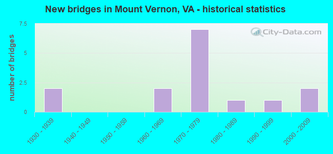
- New bridges - historical statistics
- 21930-1939
- 21960-1969
- 71970-1979
- 11980-1989
- 11990-1999
- 22000-2009


- Bridge Condition - Deck
- 57.1%Good
- 28.6%Satisfactory
- 14.3%Fair

- Bridge Condition - Superstructure
- 14.3%Very good
- 28.6%Good
- 42.9%Satisfactory
- 14.3%Fair

- Bridge Condition - Substructure
- 42.9%Good
- 57.1%Satisfactory

- Bridge Condition - Channel
- 60.0%Satisfactory
- 40.0%Fair

- Bridge Condition - Culverts
- 25.0%Good
- 37.5%Satisfactory
- 37.5%Fair
Find on map >> Show street view
Structure Number: 6218, Location: 00.24FR3105/00.27TO235 (Lat: 38.718808, Lng: -77.128714), Route carried "on" structure: US 1, Year Built: 1933, Status: Open, Structure Length: 1.01m (3.31ft), Average Daily Traffic: 28,461 (year 2020), Truck Traffic: 3%, Average Future Daily Traffic: 35,206 (year 2040), Design Load: HS 20, Features Intersected: DOGUE CREEK, Facility Carried by Structure: JEFF DAVIS HIGHWAY
Minimum Vertical Clearance: 30+ m (98+ ft), Kilometerpoint: 297.037, Lanes on structure: 4, Base Highway Network: Yes, Owner: State Highway Agency, Approaching Roadway Width: 16.8m (55.1ft), Material/Design: Concrete, Design/Construction: Stringer/Multi-beam, Number Of Spans In Main Unit: 1, Length of Maximum Span: 9.8m (32.2ft), Curb-To-Curb Width: 16.7m (54.8ft), Out-to-Out Width: 18.9m (62.0ft)
Condition: Deck: Satisfactory, Superstructure: Satisfactory, Substructure: Satisfactory, Channel: Satisfactory, Operating Rating: 40.6 metric tons, Method Used To Determine Operating Rating: Load Factor (LF), Inventory Rating: 24.3 metric tons, Method Used To Determine Inventory Rating: Load Factor (LF), Structural Evaluation: Equal to present minimum criteria, Deck Geometry: Somewhat better than minimum adequacy, Waterway Adequacy: Equal to present minimum criteria, Approach Roadway Alignment: Equal to present desirable criteria, Length Of Structure Improvement: 1.52m (4.99ft), Designated Inspection Frequency: Every 24 months, Inspection Date: August 2020, Bridge Improvement Cost: $480,000, Roadway Improvement Cost: $48,000, Total Project Cost: $529,000, Deck Structure Type: Concrete Cast-file-Place, Wearing Surface/Protective System: Wearing Surface: Bituminous
Find on map >> Show street view
Structure Number: 6225, Location: 00.03FR235 00.25TO626 (Lat: 38.739422, Lng: -77.088525), Route carried "on" structure: US 1, Year Built: 1975, Status: Open, Structure Length: 3.14m (10.30ft), Average Daily Traffic: 45,537 (year 2020), Truck Traffic: 3%, Average Future Daily Traffic: 50,091 (year 2040), Design Load: HS 20, Features Intersected: LITTLE HUNTING CREEK, Facility Carried by Structure: RICHMOND HIGHWAY
Minimum Vertical Clearance: 30+ m (98+ ft), Kilometerpoint: 301.206, Lanes on structure: 7, Base Highway Network: Yes, Owner: State Highway Agency, Approaching Roadway Width: 27.4m (89.9ft), Skew: 20 degrees, Material/Design: Steel, Design/Construction: Stringer/Multi-beam, Number Of Spans In Main Unit: 3, Length of Maximum Span: 10.4m (34.1ft), Curb or Sidewalk Widths: Left: 1.5m (4.9ft), Right: 1.5m (4.9ft), Curb-To-Curb Width: 27.4m (89.9ft), Out-to-Out Width: 32.3m (106.0ft)
Condition: Deck: Fair, Superstructure: Fair, Substructure: Satisfactory, Channel: Satisfactory, Operating Rating: 81.0 metric tons, Method Used To Determine Operating Rating: Load and Resistance Factor (LRFR), Inventory Rating: 62.5 metric tons, Method Used To Determine Inventory Rating: Load and Resistance Factor (LRFR), Structural Evaluation: Somewhat better than minimum adequacy, Deck Geometry: Somewhat better than minimum adequacy, Waterway Adequacy: Equal to present minimum criteria, Approach Roadway Alignment: Better than present minimum criteria, Length Of Structure Improvement: 3.14m (10.30ft), Designated Inspection Frequency: Every 24 months, Inspection Date: Febuary 2022, Bridge Improvement Cost: $75,000, Roadway Improvement Cost: $10,000, Total Project Cost: $90,000 ( Estimate for 2014), Deck Structure Type: Concrete Cast-file-Place, Wearing Surface/Protective System: Wearing Surface: Epoxy Overlay
Find on map >> Show street view
Structure Number: 6226, Location: 0.11FR624 / 0.07TO778 (Lat: 38.722133, Lng: -77.121989), Route carried "on" structure: US 1, Year Built: 1979, Status: Open, Structure Length: 0.94m (3.08ft), Average Daily Traffic: 28,461 (year 2020), Truck Traffic: 3%, Average Future Daily Traffic: 35,206 (year 2040), Design Load: HS 20, Features Intersected: NORTH FORK DOGUE CREEK, Facility Carried by Structure: RICHMOND HIGHWAY
Minimum Vertical Clearance: 30+ m (98+ ft), Kilometerpoint: 297.713, Lanes on structure: 4, Base Highway Network: Yes, Owner: State Highway Agency, Approaching Roadway Width: 12.2m (40.0ft), Material/Design: Concrete, Design/Construction: Culvert, Number Of Spans In Main Unit: 3, Length of Maximum Span: 3.0m (9.8ft)
Condition: Channel: Fair, Culverts: Satisfactory, Operating Rating: 64.4 metric tons, Method Used To Determine Operating Rating: Load Factor (LF), Inventory Rating: 38.1 metric tons, Method Used To Determine Inventory Rating: Load Factor (LF), Structural Evaluation: Equal to present minimum criteria, Waterway Adequacy: Equal to present desirable criteria, Approach Roadway Alignment: Equal to present desirable criteria, Length Of Structure Improvement: 12.10m (39.70ft), Designated Inspection Frequency: Every 24 months, Inspection Date: July 2020, Bridge Improvement Cost: $55,000, Roadway Improvement Cost: $99,000, Total Project Cost: $200,000 ( Estimate for 2014)
Find on map >> Show street view
Structure Number: 6483, Location: 00.21 4232 / 00.13 3108 (Lat: 38.709353, Lng: -77.108619), Route carried "on" structure: State highway 235, Year Built: 1960, Status: Open, Structure Length: 0.79m (2.59ft), Average Daily Traffic: 10,159 (year 2020), Truck Traffic: 3%, Average Future Daily Traffic: 13,504 (year 2040), Design Load: HS 20, Features Intersected: TRIBUTARY OF DOGUE CREEK, Facility Carried by Structure: MOUNT VERNON HIWAY
Minimum Vertical Clearance: 30+ m (98+ ft), Kilometerpoint: 2.600, Lanes on structure: 2, Base Highway Network: Yes, Owner: State Highway Agency, Approaching Roadway Width: 13.7m (44.9ft), Material/Design: Concrete, Design/Construction: Culvert, Number Of Spans In Main Unit: 3, Length of Maximum Span: 2.4m (7.9ft)
Condition: Channel: Satisfactory, Culverts: Fair, Operating Rating: 86.2 metric tons, Method Used To Determine Operating Rating: Load Factor (LF), Inventory Rating: 51.7 metric tons, Method Used To Determine Inventory Rating: Load Factor (LF), Structural Evaluation: Somewhat better than minimum adequacy, Waterway Adequacy: Somewhat better than minimum adequacy, Approach Roadway Alignment: Better than present minimum criteria, Designated Inspection Frequency: Every 24 months, Inspection Date: August 2021, Bridge Improvement Cost: $2,000, Roadway Improvement Cost: $1,000, Total Project Cost: $4,000
Find on map >> Show street view
Structure Number: 6723, Location: 00.05 3196 / 00.13 3012 (Lat: 38.731094, Lng: -77.116994), Route carried "on" structure: County highway 622, Year Built: 1971, Status: Open, Structure Length: 0.94m (3.08ft), Average Daily Traffic: 5,240 (year 2020), Truck Traffic: 3%, Average Future Daily Traffic: 5,764 (year 2040), Design Load: HS 20, Features Intersected: BRANCH OF DOGUE CREEK, Facility Carried by Structure: POLE ROAD
Minimum Vertical Clearance: 30+ m (98+ ft), Kilometerpoint: 1.939, Lanes on structure: 2, Owner: State Highway Agency, Approaching Roadway Width: 7.0m (23.0ft), Material/Design: Concrete, Design/Construction: Culvert, Number Of Spans In Main Unit: 3, Length of Maximum Span: 3.0m (9.8ft)
Condition: Channel: Fair, Culverts: Satisfactory, Operating Rating: 57.2 metric tons, Method Used To Determine Operating Rating: Load Factor (LF), Inventory Rating: 34.5 metric tons, Method Used To Determine Inventory Rating: Load Factor (LF), Structural Evaluation: Equal to present minimum criteria, Waterway Adequacy: Somewhat better than minimum adequacy, Approach Roadway Alignment: Better than present minimum criteria, Length Of Structure Improvement: 3.38m (11.09ft), Designated Inspection Frequency: Every 24 months, Inspection Date: August 2021, Bridge Improvement Cost: $29,000, Roadway Improvement Cost: $44,000, Total Project Cost: $75,000
Find on map >> Show street view
Structure Number: 6726, Location: 00.20 1169 / 00.38 3106 (Lat: 38.710961, Lng: -77.124675), Route carried "on" structure: County highway 623, Year Built: 1974, Year Reconstructed: 1993, Status: Open, Structure Length: 1.58m (5.18ft), Average Daily Traffic: 1,558 (year 2020), Truck Traffic: 2%, Average Future Daily Traffic: 1,714 (year 2040), Design Load: HS 20, Features Intersected: DOGUE CREEK, Facility Carried by Structure: OLD MILL ROAD
Minimum Vertical Clearance: 30+ m (98+ ft), Kilometerpoint: 1.255, Lanes on structure: 2, Owner: State Highway Agency, Approaching Roadway Width: 7.6m (24.9ft), Material/Design: Prestressed concrete, Design/Construction: Box Beam or Girders - Multiple, Number Of Spans In Main Unit: 1, Length of Maximum Span: 15.2m (49.9ft), Curb-To-Curb Width: 8.2m (26.9ft), Out-to-Out Width: 9.8m (32.2ft)
Condition: Deck: Good, Superstructure: Good, Substructure: Good, Channel: Satisfactory, Operating Rating: 77.0 metric tons, Method Used To Determine Operating Rating: Load and Resistance Factor (LRFR), Inventory Rating: 59.4 metric tons, Method Used To Determine Inventory Rating: Load and Resistance Factor (LRFR), Structural Evaluation: Better than present minimum criteria, Deck Geometry: Meets minimum limits, Waterway Adequacy: Equal to present minimum criteria, Approach Roadway Alignment: Equal to present minimum criteria, Length Of Structure Improvement: 1.62m (5.31ft), Designated Inspection Frequency: Every 24 months, Inspection Date: June 2021, Bridge Improvement Cost: $55,000, Roadway Improvement Cost: $75,000, Total Project Cost: $175,000 ( Estimate for 2015), Deck Structure Type: Concrete Precast Panels, Wearing Surface/Protective System: Wearing Surface: Bituminous, Membrane: Epoxy, Deck Protection: Epoxy Coated Reinforcing
Find on map >> Show street view
Structure Number: 6727, Location: 00.03FR1033/00.04TO1267 (Lat: 38.727083, Lng: -77.119831), Route carried "on" structure: County highway 624, Year Built: 1982, Status: Open, Structure Length: 1.31m (4.30ft), Average Daily Traffic: 1,107 (year 2011), Average Future Daily Traffic: 1,268 (year 2040), Design Load: HS 20, Features Intersected: BRANCH OF DOGUE CREEK, Facility Carried by Structure: HIGHLAND LANE
Minimum Vertical Clearance: 30+ m (98+ ft), Kilometerpoint: 0.354, Lanes on structure: 2, Owner: State Highway Agency, Approaching Roadway Width: 7.0m (23.0ft), Skew: 1 degrees, Material/Design: Concrete, Design/Construction: Culvert, Number Of Spans In Main Unit: 4, Length of Maximum Span: 3.0m (9.8ft), Curb or Sidewalk Widths: Left: 1.8m (5.9ft), Right: 1.8m (5.9ft)
Condition: Channel: Satisfactory, Culverts: Good, Operating Rating: 63.5 metric tons, Method Used To Determine Operating Rating: Load Factor (LF), Inventory Rating: 38.1 metric tons, Method Used To Determine Inventory Rating: Load Factor (LF), Structural Evaluation: Better than present minimum criteria, Waterway Adequacy: Better than present minimum criteria, Approach Roadway Alignment: Equal to present desirable criteria, Length Of Structure Improvement: 0.30m (0.98ft), Designated Inspection Frequency: Every 24 months, Inspection Date: July 2020, Bridge Improvement Cost: $1,000, Roadway Improvement Cost: $1,000, Total Project Cost: $3,000 ( Estimate for 2014)
Find on map >> Show street view
Structure Number: 6924, Location: 00.03FR1097/00.04TO1038 (Lat: 38.724419, Lng: -77.103139), Route carried "on" structure: County highway 1096, Year Built: 1964, Status: Open, Structure Length: 0.64m (2.10ft), Average Daily Traffic: 638 (year 2011), Average Future Daily Traffic: 884 (year 2040), Design Load: HS 20, Features Intersected: BRANCH OF DOGUE CREEK, Facility Carried by Structure: WOODLEY ROAD
Minimum Vertical Clearance: 30+ m (98+ ft), Kilometerpoint: 0.188, Lanes on structure: 2, Owner: State Highway Agency, Approaching Roadway Width: 9.4m (30.8ft), Material/Design: Concrete, Design/Construction: Culvert, Number Of Spans In Main Unit: 2, Length of Maximum Span: 3.0m (9.8ft)
Condition: Channel: Fair, Culverts: Good, Operating Rating: 68.9 metric tons, Method Used To Determine Operating Rating: Load Factor (LF), Inventory Rating: 40.8 metric tons, Method Used To Determine Inventory Rating: Load Factor (LF), Structural Evaluation: Better than present minimum criteria, Waterway Adequacy: Equal to present minimum criteria, Approach Roadway Alignment: Better than present minimum criteria, Length Of Structure Improvement: 2.87m (9.42ft), Designated Inspection Frequency: Every 24 months, Inspection Date: August 2021, Bridge Improvement Cost: $10,000, Roadway Improvement Cost: $10,000, Total Project Cost: $50,000
Find on map >> Show street view
Structure Number: 693, Location: 00.02FR6005/00.00TO END (Lat: 38.740778, Lng: -77.095614), Route carried "on" structure: County highway 1202, Year Built: 1974, Status: Open, Structure Length: 3.14m (10.30ft), Average Daily Traffic: 3,490 (year 2011), Average Future Daily Traffic: 5,514 (year 2040), Design Load: HS 20+Mod, Features Intersected: LITTLE HUNTING CREEK, Facility Carried by Structure: JANNA LEE AVE.
Minimum Vertical Clearance: 30+ m (98+ ft), Kilometerpoint: 0.499, Lanes on structure: 2, Owner: State Highway Agency, Approaching Roadway Width: 13.4m (44.0ft), Material/Design: Steel, Design/Construction: Stringer/Multi-beam, Number Of Spans In Main Unit: 3, Length of Maximum Span: 10.4m (34.1ft), Curb or Sidewalk Widths: Left: 0.5m (1.6ft), Right: 1.5m (4.9ft), Curb-To-Curb Width: 13.4m (44.0ft), Out-to-Out Width: 16.2m (53.1ft)
Condition: Deck: Good, Superstructure: Satisfactory, Substructure: Satisfactory, Channel: Satisfactory, Operating Rating: 89.8 metric tons, Method Used To Determine Operating Rating: Load and Resistance Factor (LRFR), Inventory Rating: 88.0 metric tons, Method Used To Determine Inventory Rating: Load and Resistance Factor (LRFR), Structural Evaluation: Equal to present minimum criteria, Deck Geometry: Better than present minimum criteria, Waterway Adequacy: Equal to present desirable criteria, Approach Roadway Alignment: Equal to present desirable criteria, Length Of Structure Improvement: 3.14m (10.30ft), Designated Inspection Frequency: Every 24 months, Inspection Date: Febuary 2022, Bridge Improvement Cost: $55,000, Roadway Improvement Cost: $67,000, Total Project Cost: $150,000, Deck Structure Type: Concrete Cast-file-Place
Find on map >> Show street view
Structure Number: 6972, Location: 00.06 3183 / 00.08 3722 (Lat: 38.734325, Lng: -77.114467), Route carried "on" structure: County highway 3191, Year Built: 1971, Status: Open, Structure Length: 1.04m (3.41ft), Average Daily Traffic: 2,930 (year 2020), Truck Traffic: 2%, Average Future Daily Traffic: 3,223 (year 2040), Design Load: HS 20, Features Intersected: BRANCH OF DOGUE CREEK, Facility Carried by Structure: FRYE ROAD
Minimum Vertical Clearance: 30+ m (98+ ft), Kilometerpoint: 0.837, Lanes on structure: 2, Owner: State Highway Agency, Approaching Roadway Width: 12.2m (40.0ft), Material/Design: Concrete, Design/Construction: Culvert, Number Of Spans In Main Unit: 3, Length of Maximum Span: 3.0m (9.8ft), Curb or Sidewalk Widths: Left: 2.4m (7.9ft), Right: 0.9m (3.0ft)
Condition: Channel: Satisfactory, Culverts: Fair, Operating Rating: 61.7 metric tons, Method Used To Determine Operating Rating: Load Factor (LF), Inventory Rating: 37.2 metric tons, Method Used To Determine Inventory Rating: Load Factor (LF), Structural Evaluation: Somewhat better than minimum adequacy, Waterway Adequacy: Better than present minimum criteria, Approach Roadway Alignment: Equal to present minimum criteria, Length Of Structure Improvement: 0.30m (0.98ft), Designated Inspection Frequency: Every 24 months, Inspection Date: January 2022, Bridge Improvement Cost: $1,000, Roadway Improvement Cost: $1,000, Total Project Cost: $3,000
Find on map >> Show street view
Structure Number: 6973, Location: 00.20FR622/00.05TO3197 (Lat: 38.733650, Lng: -77.116847), Route carried "on" structure: County highway 3196, Year Built: 1971, Status: Open, Structure Length: 0.94m (3.08ft), Average Daily Traffic: 1,326 (year 2016), Average Future Daily Traffic: 1,411 (year 2040), Design Load: HS 20, Features Intersected: BRANCH OF DOGUE CREEK, Facility Carried by Structure: KEELER STREET
Minimum Vertical Clearance: 30+ m (98+ ft), Kilometerpoint: 0.322, Lanes on structure: 2, Owner: State Highway Agency, Approaching Roadway Width: 11.0m (36.1ft), Material/Design: Concrete, Design/Construction: Culvert, Number Of Spans In Main Unit: 3, Length of Maximum Span: 3.0m (9.8ft), Curb or Sidewalk Widths: Left: 1.1m (3.6ft), Right: 1.1m (3.6ft)
Condition: Channel: Fair, Culverts: Fair, Operating Rating: 57.2 metric tons, Method Used To Determine Operating Rating: Load Factor (LF), Inventory Rating: 34.5 metric tons, Method Used To Determine Inventory Rating: Load Factor (LF), Structural Evaluation: Somewhat better than minimum adequacy, Waterway Adequacy: Better than present minimum criteria, Approach Roadway Alignment: Better than present minimum criteria, Length Of Structure Improvement: 4.02m (13.19ft), Designated Inspection Frequency: Every 24 months, Inspection Date: July 2021, Bridge Improvement Cost: $35,000, Roadway Improvement Cost: $15,000, Total Project Cost: $55,000 ( Estimate for 2015)
Find on map >> Show street view
Structure Number: 24316, Location: 00.10FR915/00.05TO622 (Lat: 38.731553, Lng: -77.113314), Route carried "on" structure: County highway 3191, Year Built: 1995, Status: Open, Structure Length: 0.73m (2.40ft), Average Daily Traffic: 4,002 (year 2020), Truck Traffic: 2%, Average Future Daily Traffic: 4,987 (year 2040), Design Load: HS 20, Features Intersected: TRIB. OF DOGUE CREEK, Facility Carried by Structure: FRYE ROAD
Minimum Vertical Clearance: 30+ m (98+ ft), Kilometerpoint: 0.628, Lanes on structure: 2, Owner: State Highway Agency, Approaching Roadway Width: 6.7m (22.0ft), Skew: 1 degrees, Material/Design: Concrete, Design/Construction: Culvert, Number Of Spans In Main Unit: 3, Length of Maximum Span: 2.4m (7.9ft)
Condition: Channel: Fair, Culverts: Satisfactory, Operating Rating: 65.3 metric tons, Method Used To Determine Operating Rating: Load Factor (LF), Inventory Rating: 39.0 metric tons, Method Used To Determine Inventory Rating: Load Factor (LF), Structural Evaluation: Equal to present minimum criteria, Waterway Adequacy: Somewhat better than minimum adequacy, Approach Roadway Alignment: Equal to present desirable criteria, Length Of Structure Improvement: 0.30m (0.98ft), Designated Inspection Frequency: Every 24 months, Inspection Date: January 2022, Bridge Improvement Cost: $1,000, Roadway Improvement Cost: $1,000, Total Project Cost: $3,000
Find on map >> Show street view
Structure Number: 25725, Location: 00.50FR624/00.35TO235 (Lat: 38.715961, Lng: -77.108467), Route carried "on" structure: County highway 624, Year Built: 2000, Status: Open, Structure Length: 2.65m (8.69ft), Average Daily Traffic: 2,105 (year 2020), Truck Traffic: 2%, Average Future Daily Traffic: 2,316 (year 2040), Design Load: HS 20+Mod, Features Intersected: NORTH FORK DOGUE CREEK, Facility Carried by Structure: OLD MILL ROAD
Minimum Vertical Clearance: 30+ m (98+ ft), Kilometerpoint: 2.430, Lanes on structure: 2, Owner: State Highway Agency, Approaching Roadway Width: 7.3m (24.0ft), Material/Design: Prestressed concrete, Design/Construction: Slab, Number Of Spans In Main Unit: 3, Length of Maximum Span: 8.8m (28.9ft), Curb or Sidewalk Widths: Left: 1.8m (5.9ft), Right: 0.0m, Curb-To-Curb Width: 9.8m (32.2ft), Out-to-Out Width: 12.2m (40.0ft)
Condition: Deck: Good, Superstructure: Good, Substructure: Good, Channel: Satisfactory, Operating Rating: 86.2 metric tons, Method Used To Determine Operating Rating: Load and Resistance Factor (LRFR), Inventory Rating: 66.2 metric tons, Method Used To Determine Inventory Rating: Load and Resistance Factor (LRFR), Structural Evaluation: Better than present minimum criteria, Deck Geometry: Meets minimum limits, Waterway Adequacy: Somewhat better than minimum adequacy, Approach Roadway Alignment: Equal to present desirable criteria, Length Of Structure Improvement: 2.65m (8.69ft), Designated Inspection Frequency: Every 24 months, Inspection Date: July 2020, Bridge Improvement Cost: $100,000, Roadway Improvement Cost: $20,000, Total Project Cost: $150,000 ( Estimate for 2014), Deck Structure Type: Concrete Precast Panels, Wearing Surface/Protective System: Wearing Surface: Integral Concrete, Deck Protection: Epoxy Coated Reinforcing
Find on map >> Show street view
Structure Number: 26428, Location: 00.05fr6988/00.10to624 (Lat: 38.716833, Lng: -77.120222), Route carried "on" structure: County highway 623, Year Built: 2000, Status: Open, Structure Length: 1.16m (3.81ft), Average Daily Traffic: 1,558 (year 2020), Truck Traffic: 2%, Average Future Daily Traffic: 1,714 (year 2040), Design Load: HS 20+Mod, Features Intersected: BRANCH OF DOGUE CREEK, Facility Carried by Structure: OLD MILL ROAD
Minimum Vertical Clearance: 30+ m (98+ ft), Kilometerpoint: 0.225, Lanes on structure: 2, Owner: State Highway Agency, Approaching Roadway Width: 7.3m (24.0ft), Skew: 1 degrees, Material/Design: Steel, Design/Construction: Stringer/Multi-beam, Number Of Spans In Main Unit: 1, Length of Maximum Span: 10.4m (34.1ft), Curb or Sidewalk Widths: Left: 1.5m (4.9ft), Right: 3.0m (9.8ft), Curb-To-Curb Width: 7.8m (25.6ft), Out-to-Out Width: 13.1m (43.0ft)
Condition: Deck: Good, Superstructure: Very good, Substructure: Good, Channel: Satisfactory, Operating Rating: 89.8 metric tons, Method Used To Determine Operating Rating: Load and Resistance Factor (LRFR), Inventory Rating: 71.7 metric tons, Method Used To Determine Inventory Rating: Load and Resistance Factor (LRFR), Structural Evaluation: Better than present minimum criteria, Deck Geometry: Meets minimum limits, Waterway Adequacy: Better than present minimum criteria, Approach Roadway Alignment: Equal to present desirable criteria, Length Of Structure Improvement: 1.16m (3.81ft), Designated Inspection Frequency: Every 24 months, Inspection Date: July 2020, Bridge Improvement Cost: $44,000, Roadway Improvement Cost: $55,000, Total Project Cost: $150,000 ( Estimate for 2014), Deck Structure Type: Concrete Cast-file-Place, Wearing Surface/Protective System: Deck Protection: Epoxy Coated Reinforcing
Find on map >> Show street view
Structure Number: 3300026P, Location: 8.6 MILES SOUTH OF I-95/4 (Lat: 38.712811, Lng: -77.074006), Route carried "on" structure: Federal lands road 3, Year Built: 1932, Status: Open, Structure Length: 4.40m (14.44ft), Average Daily Traffic: 10,000 (year 2013), Truck Traffic: 1%, Average Future Daily Traffic: 11,000 (year 2033), Features Intersected: LITTLE HUNTING CREEK, Facility Carried by Structure: GEORGE WASHINGTON
Minimum Vertical Clearance: 30+ m (98+ ft), Kilometerpoint: 11.491, Lanes on structure: 4, Owner: National Park Service, Approaching Roadway Width: 13.1m (43.0ft), Material/Design: Concrete, Design/Construction: Arch - Deck, Number Of Spans In Main Unit: 1, Number Of Approach Spans: 2, Length of Maximum Span: 15.9m (52.2ft), Curb or Sidewalk Widths: Left: 1.8m (5.9ft), Right: 0.0m, Curb-To-Curb Width: 13.1m (43.0ft), Out-to-Out Width: 21.2m (69.6ft)
Condition: Deck: Satisfactory, Superstructure: Satisfactory, Substructure: Satisfactory, Channel: Fair, Operating Rating: 37.2 metric tons, Method Used To Determine Operating Rating: Load Factor (LF), Inventory Rating: 21.8 metric tons, Method Used To Determine Inventory Rating: Load Factor (LF), Structural Evaluation: Somewhat better than minimum adequacy, Deck Geometry: High priority of replacement, Waterway Adequacy: Equal to present desirable criteria, Approach Roadway Alignment: Equal to present desirable criteria, Designated Inspection Frequency: Every 24 months, Underwater Inspection Frequency: Every 60 months, Inspection Date: April 2021, Underwater Inspection Date: July 2018, Bridge Improvement Cost: $6,000,000, Roadway Improvement Cost: $600,000, Total Project Cost: $9,000,000, Deck Structure Type: Concrete Cast-file-Place, Wearing Surface/Protective System: Wearing Surface: Integral Concrete