Bridge Statistics for Mount Dora, Florida (FL)
Condition, Traffic, Stress, Structural Evaluation, Project Costs
- National Bridge Inventory (NBI) Statistics
- 14Number of bridges
- 154ft / 46.8mTotal length
- 114,870Total average daily traffic
- 14,620Total average daily truck traffic
- National Bridge Inventory (NBI) Registered Bridges for Mount Dora
- No street view available for this location
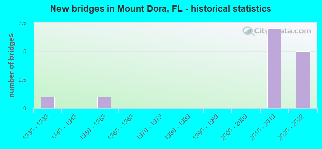
- New bridges - historical statistics
- 11930-1939
- 11950-1959
- 72010-2019
- 52020-2022


- Bridge Condition - Deck
- 28.6%Excellent
- 57.1%Very good
- 14.3%Good

- Bridge Condition - Superstructure
- 28.6%Excellent
- 42.9%Very good
- 28.6%Good

- Bridge Condition - Substructure
- 14.3%Excellent
- 71.4%Very good
- 14.3%Good
Find on map >> Show street view
Structure Number: 110094, Location: SR46 EB over Pond Rd (Lat: 28.797503, Lng: -81.621678), Route carried "on" structure: State highway 46, Year Built: 2020, Status: Open, Structure Length: 3.05m (10.01ft), Average Daily Traffic: 3,800 (year 2020), Truck Traffic: 7%, Average Future Daily Traffic: 6,593 (year 2042), Design Load: HL 93, Features Intersected: Pond Road
Minimum Vertical Clearance: 30+ m (98+ ft), Kilometerpoint: 0.752, Lanes on structure: 2, Lanes under structure: 2, Owner: State Highway Agency, Approaching Roadway Width: 12.2m (40.0ft), Material/Design: Prestressed concrete, Design/Construction: Stringer/Multi-beam, Number Of Spans In Main Unit: 1, Length of Maximum Span: 29.9m (98.1ft), Curb-To-Curb Width: 12.2m (40.0ft), Out-to-Out Width: 13.1m (43.0ft)
Condition: Deck: Excellent, Superstructure: Excellent, Substructure: Excellent, Operating Rating: 40.2 metric tons, Method Used To Determine Operating Rating: Load and Resistance Factor (LRFR), Inventory Rating: 36.3 metric tons, Method Used To Determine Inventory Rating: Load and Resistance Factor (LRFR), Structural Evaluation: Superior to present desirable criteria, Deck Geometry: Better than present minimum criteria, Underclear: Superior to present desirable criteria, Approach Roadway Alignment: Equal to present desirable criteria, Designated Inspection Frequency: Every 24 months, Inspection Date: April 2020, Deck Structure Type: Concrete Cast-file-Place, Wearing Surface/Protective System: Wearing Surface: Monolithic Concrete
Find on map >> Show street view
Structure Number: 110095, Location: US441 SB to SR 46 (Lat: 28.796944, Lng: -81.625083), Route carried "on" structure: Ramp State highway 441, Year Built: 2020, Status: Open, Structure Length: 14.42m (47.31ft), Average Daily Traffic: 3,800 (year 2020), Truck Traffic: 7%, Average Future Daily Traffic: 6,593 (year 2042), Design Load: HL 93, Features Intersected: SR 46 and US 441
Minimum Vertical Clearance: 30+ m (98+ ft), Kilometerpoint: 0.315, Lanes on structure: 2, Lanes under structure: 10, Base Highway Network: Yes, Owner: State Highway Agency, Approaching Roadway Width: 13.7m (44.9ft), Material/Design: Steel continuous, Design/Construction: Box Beam or Girders - Single/Spread, Number Of Spans In Main Unit: 3, Length of Maximum Span: 70.4m (231.0ft), Curb-To-Curb Width: 13.7m (44.9ft), Out-to-Out Width: 14.8m (48.6ft)
Condition: Deck: Excellent, Superstructure: Excellent, Substructure: Very good, Operating Rating: 51.3 metric tons, Method Used To Determine Operating Rating: Load and Resistance Factor (LRFR), Inventory Rating: 39.6 metric tons, Method Used To Determine Inventory Rating: Load and Resistance Factor (LRFR), Structural Evaluation: Equal to present desirable criteria, Deck Geometry: Superior to present desirable criteria, Underclear: Equal to present minimum criteria, Approach Roadway Alignment: Better than present minimum criteria, Designated Inspection Frequency: Every 24 months, Critical Feature Inspection Frequency: Every 24 months, Inspection Date: April 2020, Critical Feature Inspection Date: April 2020, Deck Structure Type: Concrete Cast-file-Place
Find on map >> Show street view
Structure Number: 110123, Location: 0.3 Mi. S of SR-46 (Lat: 28.798389, Lng: -81.586194), Route carried "on" structure: Other road 453, Year Built: 2018, Status: Open, Structure Length: 3.21m (10.53ft), Average Daily Traffic: 4,750 (year 2020), Truck Traffic: 7%, Average Future Daily Traffic: 8,241 (year 2042), Design Load: HL 93, Features Intersected: Coronado Somerset Dr
Minimum Vertical Clearance: 30.45m (99.90ft), Kilometerpoint: 1.782, Lanes on structure: 3, Lanes under structure: 2, Base Highway Network: Yes, Toll: On toll road, Owner: State Toll Authority, Approaching Roadway Width: 17.1m (56.1ft), Skew: 4 degrees, Material/Design: Prestressed concrete, Design/Construction: Box Beam or Girders - Single/Spread, Number Of Spans In Main Unit: 1, Length of Maximum Span: 32.1m (105.3ft), Curb-To-Curb Width: 17.1m (56.1ft), Out-to-Out Width: 18.0m (59.1ft)
Condition: Deck: Very good, Superstructure: Very good, Substructure: Very good, Operating Rating: 72.2 metric tons, Method Used To Determine Operating Rating: Load and Resistance Factor (LRFR), Inventory Rating: 39.2 metric tons, Method Used To Determine Inventory Rating: Load and Resistance Factor (LRFR), Structural Evaluation: Equal to present desirable criteria, Deck Geometry: Superior to present desirable criteria, Underclear: Superior to present desirable criteria, Approach Roadway Alignment: Better than present minimum criteria, Designated Inspection Frequency: Every 24 months, Inspection Date: January 2022, Deck Structure Type: Concrete Cast-file-Place
Find on map >> Show street view
Structure Number: 110124, Location: 3.5 Mi N of Kelly Park Rd (Lat: 28.798472, Lng: -81.585917), Route carried "on" structure: State highway 453, Year Built: 2018, Status: Open, Structure Length: 3.21m (10.53ft), Average Daily Traffic: 4,750 (year 2020), Truck Traffic: 7%, Average Future Daily Traffic: 8,241 (year 2042), Design Load: HL 93, Features Intersected: Coronado Somerset Dr.
Minimum Vertical Clearance: 30.45m (99.90ft), Kilometerpoint: 1.782, Lanes on structure: 3, Lanes under structure: 2, Toll: On toll road, Owner: State Toll Authority, Approaching Roadway Width: 17.1m (56.1ft), Skew: 4 degrees, Material/Design: Prestressed concrete, Design/Construction: Box Beam or Girders - Single/Spread, Number Of Spans In Main Unit: 1, Length of Maximum Span: 32.1m (105.3ft), Curb-To-Curb Width: 17.1m (56.1ft), Out-to-Out Width: 18.0m (59.1ft)
Condition: Deck: Very good, Superstructure: Very good, Substructure: Very good, Operating Rating: 71.2 metric tons, Method Used To Determine Operating Rating: Load and Resistance Factor (LRFR), Inventory Rating: 39.8 metric tons, Method Used To Determine Inventory Rating: Load and Resistance Factor (LRFR), Structural Evaluation: Equal to present desirable criteria, Deck Geometry: Superior to present desirable criteria, Underclear: Superior to present desirable criteria, Approach Roadway Alignment: Better than present minimum criteria, Designated Inspection Frequency: Every 24 months, Inspection Date: January 2022, Deck Structure Type: Concrete Cast-file-Place
Find on map >> Show street view
Structure Number: 110125, Location: 3.7 Mi N of Kelley Pk Rd. (Lat: 28.800750, Lng: -81.588333), Route carried "on" structure: Ramp Other road 453, Year Built: 2018, Status: Open, Structure Length: 8.87m (29.10ft), Average Daily Traffic: 4,600 (year 2020), Truck Traffic: 7%, Average Future Daily Traffic: 7,981 (year 2042), Design Load: HL 93, Features Intersected: FCEN & SR-46
Minimum Vertical Clearance: 30.45m (99.90ft), Kilometerpoint: 0.262, Lanes on structure: 4, Lanes under structure: 4, Toll: On toll road, Owner: State Toll Authority, Approaching Roadway Width: 26.6m (87.3ft), Skew: 30 degrees, Material/Design: Steel continuous, Design/Construction: Stringer/Multi-beam, Number Of Spans In Main Unit: 2, Length of Maximum Span: 46.3m (151.9ft), Curb-To-Curb Width: 26.6m (87.3ft), Out-to-Out Width: 28.0m (91.9ft)
Condition: Deck: Very good, Superstructure: Very good, Substructure: Very good, Operating Rating: 50.6 metric tons, Method Used To Determine Operating Rating: Load and Resistance Factor (LRFR), Inventory Rating: 39.2 metric tons, Method Used To Determine Inventory Rating: Load and Resistance Factor (LRFR), Structural Evaluation: Equal to present desirable criteria, Deck Geometry: Superior to present desirable criteria, Underclear: Better than present minimum criteria, Approach Roadway Alignment: Equal to present minimum criteria, Designated Inspection Frequency: Every 24 months, Inspection Date: January 2022, Deck Structure Type: Concrete Cast-file-Place
Find on map >> Show street view
Structure Number: 110126, Location: 0.2 Mi E of Round Lake Rd (Lat: 28.800750, Lng: -81.588972), Route carried "on" structure: Ramp State highway 453, Year Built: 2018, Status: Open, Structure Length: 8.35m (27.40ft), Average Daily Traffic: 3,700 (year 2020), Truck Traffic: 7%, Average Future Daily Traffic: 6,420 (year 2042), Design Load: HL 93, Features Intersected: FCEN
Minimum Vertical Clearance: 30+ m (98+ ft), Kilometerpoint: 0.797, Lanes on structure: 2, Toll: On toll road, Owner: State Toll Authority, Approaching Roadway Width: 12.2m (40.0ft), Material/Design: Steel continuous, Design/Construction: Box Beam or Girders - Single/Spread, Number Of Spans In Main Unit: 2, Length of Maximum Span: 47.2m (154.9ft), Curb-To-Curb Width: 12.2m (40.0ft), Out-to-Out Width: 13.1m (43.0ft)
Condition: Deck: Very good, Superstructure: Good, Substructure: Very good, Operating Rating: 48.6 metric tons, Method Used To Determine Operating Rating: Load and Resistance Factor (LRFR), Inventory Rating: 37.6 metric tons, Method Used To Determine Inventory Rating: Load and Resistance Factor (LRFR), Structural Evaluation: Better than present minimum criteria, Deck Geometry: Superior to present desirable criteria, Approach Roadway Alignment: Equal to present minimum criteria, Designated Inspection Frequency: Every 24 months, Critical Feature Inspection Frequency: Every 24 months, Inspection Date: January 2022, Critical Feature Inspection Date: January 2022, Deck Structure Type: Concrete Cast-file-Place, Wearing Surface/Protective System: Wearing Surface: Monolithic Concrete
Find on map >> Show street view
Structure Number: 114089, Location: .4 Mi South of CR-46 (Lat: 28.790631, Lng: -81.636108), Route carried "on" structure: Alternate County highway 500A, Year Built: 1934, Status: Open, Structure Length: 5.65m (18.54ft), Average Daily Traffic: 7,000 (year 2021), Truck Traffic: 20%, Average Future Daily Traffic: 12,145 (year 2042), Design Load: HS 20, Features Intersected: S.C.L. RR
Minimum Vertical Clearance: 30+ m (98+ ft), Kilometerpoint: 11.663, Lanes on structure: 2, Owner: County Highway Agency, Approaching Roadway Width: 7.3m (24.0ft), Skew: 3 degrees, Material/Design: Concrete, Design/Construction: Tee Beam, Number Of Spans In Main Unit: 4, Length of Maximum Span: 14.2m (46.6ft), Curb or Sidewalk Widths: Left: 0.2m (0.7ft), Right: 1.7m (5.6ft), Curb-To-Curb Width: 7.3m (24.0ft), Out-to-Out Width: 9.6m (31.5ft)
Condition: Deck: Good, Superstructure: Good, Substructure: Good, Operating Rating: 57.1 metric tons, Method Used To Determine Operating Rating: Load Factor (LF), Inventory Rating: 34.3 metric tons, Method Used To Determine Inventory Rating: Load Factor (LF), Structural Evaluation: Better than present minimum criteria, Deck Geometry: High priority of replacement, Underclear: Meets minimum limits, Approach Roadway Alignment: Equal to present minimum criteria, Designated Inspection Frequency: Every 24 months, Inspection Date: August 2021, Deck Structure Type: Concrete Cast-file-Place
Find on map >> Show street view
Structure Number: 110067, Location: FCRR - US-441 (Lat: 28.791389, Lng: -81.625000), Route carried "under" structure: US 500, Year Built: 1959, Structure Length: 0. m, Average Daily Traffic: 21,500 (year 2000), Truck Traffic: 15%, Features Intersected: US-441, Facility Carried by Structure: FCEN RR
Minimum Vertical Clearance: 4.75m (15.58ft), Kilometerpoint: 36.823, Lanes under structure: 4, Material/Design: Steel, Design/Construction: Girder and Floorbeam System, Length of Maximum Span: 18.9m (62.0ft)
Find on map >> Show street view
Structure Number: 110094, Location: SR46 EB over Pond Rd (Lat: 28.797503, Lng: -81.621678), Route carried "under" structure: County highway , Year Built: 2020, Structure Length: 0. m, Average Daily Traffic: 50 (year 2020), Truck Traffic: 1%, Features Intersected: Pond Road, Facility Carried by Structure: SR 46 EB
Minimum Vertical Clearance: 5.73m (18.80ft), Kilometerpoint: 0.016, Lanes on structure: 2, Lanes under structure: 2, Material/Design: Prestressed concrete, Design/Construction: Stringer/Multi-beam, Length of Maximum Span: 29.9m (98.1ft)
Find on map >> Show street view
Structure Number: 110095, Location: US441 SB to SR 46 (Lat: 28.796944, Lng: -81.625083), Route carried "under" structure: State highway 46, Year Built: 2020, Structure Length: 0. m, Average Daily Traffic: 26,500 (year 2020), Truck Traffic: 13%, Features Intersected: SR 46 and US 441
Minimum Vertical Clearance: 5.82m (19.09ft), Kilometerpoint: 34.279, Lanes on structure: 2, Lanes under structure: 4, Material/Design: Steel continuous, Design/Construction: Box Beam or Girders - Single/Spread, Length of Maximum Span: 70.4m (231.0ft)
Find on map >> Show street view
Structure Number: 110095, Location: US441 SB to SR 46 (Lat: 28.796944, Lng: -81.625083), Route carried "under" structure: US 500, Year Built: 2020, Structure Length: 0. m, Average Daily Traffic: 21,500 (year 2020), Truck Traffic: 15%, Features Intersected: SR 46 and US 441, Facility Carried by Structure: US441 SB to SR 46
Minimum Vertical Clearance: 5.82m (19.09ft), Kilometerpoint: 30.095, Lanes on structure: 2, Lanes under structure: 6, Material/Design: Steel continuous, Design/Construction: Box Beam or Girders - Single/Spread, Length of Maximum Span: 70.4m (231.0ft)
Find on map >> Show street view
Structure Number: 110123, Location: 0.3 Mi. S of SR-46 (Lat: 28.798389, Lng: -81.586194), Route carried "under" structure: Alternate City street , Year Built: 2018, Structure Length: 0. m, Average Daily Traffic: 10 (year 2022), Features Intersected: Coronado Somerset Dr, Facility Carried by Structure: SR 453 SB
Minimum Vertical Clearance: 8.26m (27.10ft), Kilometerpoint: 0.000, Lanes on structure: 3, Lanes under structure: 2, Material/Design: Prestressed concrete, Design/Construction: Box Beam or Girders - Single/Spread, Length of Maximum Span: 32.1m (105.3ft)
Find on map >> Show street view
Structure Number: 110124, Location: 3.5 Mi N of Kelly Park Rd (Lat: 28.798472, Lng: -81.585917), Route carried "under" structure: City street , Year Built: 2018, Structure Length: 0. m, Average Daily Traffic: 10 (year 2018), Features Intersected: Coronado Somerset Dr., Facility Carried by Structure: SR 453 NB
Minimum Vertical Clearance: 7.68m (25.20ft), Kilometerpoint: 0.000, Lanes on structure: 3, Lanes under structure: 2, Material/Design: Prestressed concrete, Design/Construction: Box Beam or Girders - Single/Spread, Length of Maximum Span: 32.1m (105.3ft)
Find on map >> Show street view
Structure Number: 110125, Location: 3.7 Mi N of Kelley Pk Rd. (Lat: 28.800750, Lng: -81.588333), Route carried "under" structure: State highway 46, Year Built: 2018, Structure Length: 0. m, Average Daily Traffic: 12,900 (year 2020), Truck Traffic: 12%, Features Intersected: FCEN & SR-46, Facility Carried by Structure: SR 453 Ramps C & D
Minimum Vertical Clearance: 5.36m (17.59ft), Kilometerpoint: 4.828, Lanes on structure: 4, Lanes under structure: 4, Material/Design: Steel continuous, Design/Construction: Stringer/Multi-beam, Length of Maximum Span: 46.3m (151.9ft)