Bridge Statistics for Moundsville, West Virginia (WV)
Condition, Traffic, Stress, Structural Evaluation, Project Costs
- National Bridge Inventory (NBI) Statistics
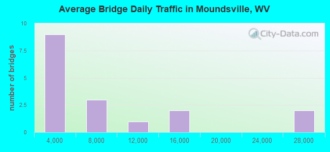
- 17Number of bridges
- 407ft / 124mTotal length
- $8,132,000Total costs
- 118,135Total average daily traffic
- 7,893Total average daily truck traffic
- National Bridge Inventory (NBI) Registered Bridges for Moundsville
- No street view available for this location

- New bridges - historical statistics
- 11920-1929
- 11930-1939
- 11950-1959
- 21960-1969
- 21970-1979
- 51980-1989
- 31990-1999
- 22010-2019
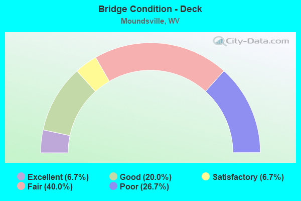
- Bridge Condition - Deck
- 6.7%Excellent
- 20.0%Good
- 6.7%Satisfactory
- 40.0%Fair
- 26.7%Poor
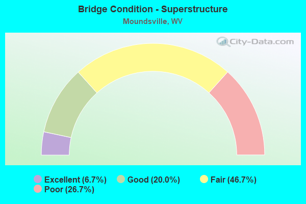
- Bridge Condition - Superstructure
- 6.7%Excellent
- 20.0%Good
- 46.7%Fair
- 26.7%Poor
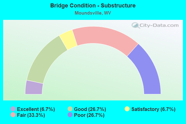
- Bridge Condition - Substructure
- 6.7%Excellent
- 26.7%Good
- 6.7%Satisfactory
- 33.3%Fair
- 26.7%Poor
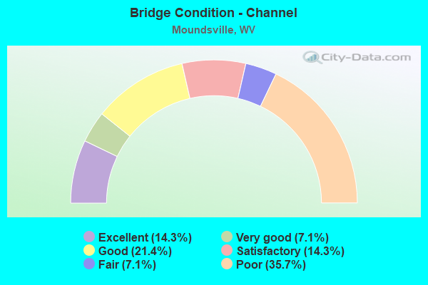
- Bridge Condition - Channel
- 14.3%Excellent
- 7.1%Very good
- 21.4%Good
- 14.3%Satisfactory
- 7.1%Fair
- 35.7%Poor
Find on map >> Show street view
Structure Number: 26A013, Location: 0.10 mi. N of jct WV 2A (Lat: 39.905589, Lng: -80.757350), Route carried "on" structure: State highway 2, Year Built: 1989, Status: Open, Structure Length: 7.79m (25.56ft), Average Daily Traffic: 7,400 (year 2019), Truck Traffic: 6%, Average Future Daily Traffic: 9,028 (year 2039), Design Load: HS 25 or greater, Features Intersected: Big Grave Creek
Minimum Vertical Clearance: 30+ m (98+ ft), Kilometerpoint: 29.033, Lanes on structure: 2, Base Highway Network: Yes, Owner: State Highway Agency, Approaching Roadway Width: 11.9m (39.0ft), Skew: 23 degrees, Material/Design: Steel continuous, Design/Construction: Stringer/Multi-beam, Number Of Spans In Main Unit: 1, Number Of Approach Spans: 2, Length of Maximum Span: 0.0m, Curb or Sidewalk Widths: Left: 0.6m (2.0ft), Right: 2.5m (8.2ft), Curb-To-Curb Width: 11.1m (36.4ft), Out-to-Out Width: 14.8m (48.6ft)
Condition: Deck: Fair, Superstructure: Fair, Substructure: Fair, Channel: Good, Operating Rating: 87.1 metric tons, Method Used To Determine Operating Rating: Load Factor (LF), Inventory Rating: 52.6 metric tons, Method Used To Determine Inventory Rating: Load Factor (LF), Structural Evaluation: Somewhat better than minimum adequacy, Deck Geometry: Equal to present minimum criteria, Waterway Adequacy: Equal to present desirable criteria, Approach Roadway Alignment: Better than present minimum criteria, Length Of Structure Improvement: 7.77m (25.49ft), Designated Inspection Frequency: Every 24 months, Underwater Inspection Frequency: Every 60 months, Inspection Date: Febuary 2021, Underwater Inspection Date: September 2021, Bridge Improvement Cost: $25,000, Total Project Cost: $252,000 ( Estimate for 2019), Deck Structure Type: Concrete Cast-file-Place
Find on map >> Show street view
Structure Number: 26A014, Location: 0.10 mi. North jct WV 2A (Lat: 39.905550, Lng: -80.757250), Route carried "on" structure: State highway 2, Year Built: 1973, Status: Open, Structure Length: 7.76m (25.46ft), Average Daily Traffic: 7,400 (year 2019), Truck Traffic: 6%, Average Future Daily Traffic: 9,028 (year 2039), Design Load: HS 20, Features Intersected: Big Grave Creek
Minimum Vertical Clearance: 30+ m (98+ ft), Kilometerpoint: 29.033, Lanes on structure: 2, Base Highway Network: Yes, Owner: State Highway Agency, Approaching Roadway Width: 11.0m (36.1ft), Skew: 23 degrees, Material/Design: Steel continuous, Design/Construction: Stringer/Multi-beam, Number Of Spans In Main Unit: 1, Number Of Approach Spans: 2, Length of Maximum Span: 30.1m (98.8ft), Curb or Sidewalk Widths: Left: 1.0m (3.3ft), Right: 0.6m (2.0ft), Curb-To-Curb Width: 9.5m (31.2ft), Out-to-Out Width: 11.2m (36.7ft)
Condition: Deck: Fair, Superstructure: Fair, Substructure: Poor, Channel: Good, Operating Rating: 70.7 metric tons, Method Used To Determine Operating Rating: Load Factor (LF), Inventory Rating: 42.6 metric tons, Method Used To Determine Inventory Rating: Load Factor (LF), Structural Evaluation: Meets minimum limits, Deck Geometry: Meets minimum limits, Waterway Adequacy: Equal to present desirable criteria, Approach Roadway Alignment: Better than present minimum criteria, Length Of Structure Improvement: 7.77m (25.49ft), Designated Inspection Frequency: Every 24 months, Underwater Inspection Frequency: Every 60 months, Inspection Date: Febuary 2021, Underwater Inspection Date: September 2021, Bridge Improvement Cost: $252,000, Total Project Cost: $252,000 ( Estimate for 2019), Deck Structure Type: Concrete Cast-file-Place, Wearing Surface/Protective System: Wearing Surface: Monolithic Concrete
Find on map >> Show street view
Structure Number: 26A015, Location: 0.06 mi. North jct WV 2SP (Lat: 39.914450, Lng: -80.747511), Route carried "on" structure: State highway 2, Year Built: 1976, Status: Open, Structure Length: 3.03m (9.94ft), Average Daily Traffic: 24,500 (year 2019), Truck Traffic: 6%, Average Future Daily Traffic: 29,890 (year 2039), Design Load: HS 20, Features Intersected: Vacant Land
Minimum Vertical Clearance: 30+ m (98+ ft), Kilometerpoint: 30.449, Lanes on structure: 4, Base Highway Network: Yes, Owner: State Highway Agency, Approaching Roadway Width: 26.2m (86.0ft), Skew: 4 degrees, Material/Design: Steel, Design/Construction: Stringer/Multi-beam, Number Of Spans In Main Unit: 1, Length of Maximum Span: 28.5m (93.5ft), Curb or Sidewalk Widths: Left: 1.5m (4.9ft), Right: 1.5m (4.9ft), Curb-To-Curb Width: 26.2m (86.0ft), Out-to-Out Width: 29.9m (98.1ft)
Condition: Deck: Fair, Superstructure: Fair, Substructure: Fair, Operating Rating: 88.9 metric tons, Method Used To Determine Operating Rating: Load Factor (LF), Inventory Rating: 62.6 metric tons, Method Used To Determine Inventory Rating: Load Factor (LF), Structural Evaluation: Somewhat better than minimum adequacy, Deck Geometry: Superior to present desirable criteria, Approach Roadway Alignment: Equal to present desirable criteria, Length Of Structure Improvement: 3.05m (10.01ft), Designated Inspection Frequency: Every 24 months, Critical Feature Inspection Frequency: Every 24 months, Inspection Date: June 2020, Critical Feature Inspection Date: June 2020, Bridge Improvement Cost: $353,000, Total Project Cost: $353,000 ( Estimate for 2020), Deck Structure Type: Concrete Cast-file-Place, Wearing Surface/Protective System: Wearing Surface: Monolithic Concrete, Deck Protection: Epoxy Coated Reinforcing
Find on map >> Show street view
Structure Number: 26A031, Location: 0.16 mi. West jct CR54 (Lat: 39.912731, Lng: -80.728481), Route carried "on" structure: County highway 17, Year Built: 1969, Status: Open, Structure Length: 3.33m (10.93ft), Average Daily Traffic: 7,700 (year 2019), Truck Traffic: 14%, Average Future Daily Traffic: 12,859 (year 2039), Design Load: HS 20, Features Intersected: Middle Grave Creek
Minimum Vertical Clearance: 30+ m (98+ ft), Kilometerpoint: 0.982, Lanes on structure: 2, Owner: State Highway Agency, Approaching Roadway Width: 6.1m (20.0ft), Skew: 12 degrees, Material/Design: Prestressed concrete, Design/Construction: Box Beam or Girders - Multiple, Number Of Spans In Main Unit: 1, Number Of Approach Spans: 2, Length of Maximum Span: 10.3m (33.8ft), Curb or Sidewalk Widths: Left: 0.9m (3.0ft), Right: 0.9m (3.0ft), Curb-To-Curb Width: 8.7m (28.5ft), Out-to-Out Width: 11.0m (36.1ft)
Condition: Deck: Fair, Superstructure: Fair, Substructure: Fair, Channel: Satisfactory, Operating Rating: 88.9 metric tons, Method Used To Determine Operating Rating: Load Factor (LF), Inventory Rating: 55.3 metric tons, Method Used To Determine Inventory Rating: Load Factor (LF), Structural Evaluation: Somewhat better than minimum adequacy, Deck Geometry: High priority of replacement, Waterway Adequacy: Somewhat better than minimum adequacy, Approach Roadway Alignment: Equal to present desirable criteria, Length Of Structure Improvement: 3.32m (10.89ft), Designated Inspection Frequency: Every 24 months, Inspection Date: October 2020, Bridge Improvement Cost: $420,000, Roadway Improvement Cost: $415,000, Total Project Cost: $840,000 ( Estimate for 2018), Deck Structure Type: Other, Wearing Surface/Protective System: Wearing Surface: Latex Concrete
Find on map >> Show street view
Structure Number: 26A041, Location: 1.32 mi. East jct CR 34 (Lat: 39.914419, Lng: -80.693269), Route carried "on" structure: County highway 36, Year Built: 1999, Status: Open, Structure Length: 1.21m (3.97ft), Average Daily Traffic: 285 (year 2017), Truck Traffic: 14%, Average Future Daily Traffic: 348 (year 2037), Design Load: HS 20, Features Intersected: Toms Run
Minimum Vertical Clearance: 30+ m (98+ ft), Kilometerpoint: 2.124, Lanes on structure: 2, Owner: State Highway Agency, Approaching Roadway Width: 6.7m (22.0ft), Skew: 4 degrees, Material/Design: Prestressed concrete, Design/Construction: Box Beam or Girders - Multiple, Number Of Spans In Main Unit: 1, Length of Maximum Span: 10.4m (34.1ft), Curb-To-Curb Width: 6.1m (20.0ft), Out-to-Out Width: 6.2m (20.3ft)
Condition: Deck: Good, Superstructure: Good, Substructure: Good, Operating Rating: 78.9 metric tons, Method Used To Determine Operating Rating: Load Factor (LF), Inventory Rating: 47.2 metric tons, Method Used To Determine Inventory Rating: Load Factor (LF), Structural Evaluation: Better than present minimum criteria, Deck Geometry: Meets minimum limits, Waterway Adequacy: Better than present minimum criteria, Approach Roadway Alignment: Equal to present minimum criteria, Length Of Structure Improvement: 1.19m (3.90ft), Designated Inspection Frequency: Every 48 months, Inspection Date: Febuary 2019, Bridge Improvement Cost: $24,000, Roadway Improvement Cost: $20,000, Total Project Cost: $44,000 ( Estimate for 2015), Deck Structure Type: Other, Wearing Surface/Protective System: Wearing Surface: Bituminous, Deck Protection: Epoxy Coated Reinforcing
Find on map >> Show street view
Structure Number: 26A046, Location: 2.25 mi. South jct CR17 (Lat: 39.885781, Lng: -80.724761), Route carried "on" structure: County highway 54, Year Built: 1991, Status: Open, Structure Length: 2.32m (7.61ft), Average Daily Traffic: 1,800 (year 2020), Truck Traffic: 14%, Average Future Daily Traffic: 2,574 (year 2040), Design Load: HS 25 or greater, Features Intersected: Big Grave Creek
Minimum Vertical Clearance: 30+ m (98+ ft), Kilometerpoint: 9.238, Lanes on structure: 2, Owner: State Highway Agency, Approaching Roadway Width: 7.0m (23.0ft), Material/Design: Prestressed concrete, Design/Construction: Box Beam or Girders - Multiple, Number Of Spans In Main Unit: 1, Length of Maximum Span: 21.9m (71.9ft), Curb-To-Curb Width: 6.7m (22.0ft), Out-to-Out Width: 7.5m (24.6ft)
Condition: Deck: Fair, Superstructure: Fair, Substructure: Good, Channel: Poor, Operating Rating: 88.9 metric tons, Method Used To Determine Operating Rating: Load Factor (LF), Inventory Rating: 56.2 metric tons, Method Used To Determine Inventory Rating: Load Factor (LF), Structural Evaluation: Somewhat better than minimum adequacy, Deck Geometry: High priority of corrective action, Waterway Adequacy: Better than present minimum criteria, Approach Roadway Alignment: Somewhat better than minimum adequacy, Length Of Structure Improvement: 2.32m (7.61ft), Designated Inspection Frequency: Every 24 months, Inspection Date: May 2021, Bridge Improvement Cost: $50,000, Roadway Improvement Cost: $49,000, Total Project Cost: $99,000 ( Estimate for 2021), Deck Structure Type: Other, Wearing Surface/Protective System: Wearing Surface: Bituminous, Deck Protection: Epoxy Coated Reinforcing
Find on map >> Show street view
Structure Number: 26A066, Location: 0.24 mi. N. jct CR250/88 (Lat: 39.926539, Lng: -80.742661), Route carried "on" structure: US 250, Year Built: 1920, Status: Posted for load, Structure Length: 0.67m (2.20ft), Average Daily Traffic: 11,300 (year 2019), Truck Traffic: 7%, Average Future Daily Traffic: 16,498 (year 2039), Features Intersected: Parrs Run
Minimum Vertical Clearance: 30+ m (98+ ft), Kilometerpoint: 50.147, Lanes on structure: 2, Base Highway Network: Yes, Owner: State Highway Agency, Approaching Roadway Width: 7.9m (25.9ft), Skew: 4 degrees, Material/Design: Concrete, Design/Construction: Slab, Number Of Spans In Main Unit: 1, Length of Maximum Span: 6.0m (19.7ft), Curb or Sidewalk Widths: Left: 1.5m (4.9ft), Right: 0.8m (2.6ft), Curb-To-Curb Width: 11.9m (39.0ft), Out-to-Out Width: 13.7m (44.9ft)
Condition: Deck: Poor, Superstructure: Poor, Substructure: Fair, Channel: Poor, Operating Rating: 29.0 metric tons, Method Used To Determine Operating Rating: Field evaluation and documented engineering judgment, Inventory Rating: 12.7 metric tons, Method Used To Determine Inventory Rating: Field evaluation and documented engineering judgment, Structural Evaluation: High priority of replacement, Deck Geometry: Somewhat better than minimum adequacy, Waterway Adequacy: Equal to present minimum criteria, Approach Roadway Alignment: Somewhat better than minimum adequacy, Length Of Structure Improvement: 1.28m (4.20ft), Designated Inspection Frequency: Every 24 months, Inspection Date: April 2020, Bridge Improvement Cost: $143,000, Roadway Improvement Cost: $142,000, Total Project Cost: $390,000 ( Estimate for 2018), Deck Structure Type: Concrete Cast-file-Place, Wearing Surface/Protective System: Wearing Surface: Bituminous
Find on map >> Show street view
Structure Number: 26A075, Location: 0.01 mi. East jct CR36 (Lat: 39.904919, Lng: -80.711431), Route carried "on" structure: County highway 34, Year Built: 1982, Status: Open, Structure Length: 1.63m (5.35ft), Average Daily Traffic: 1,500 (year 2018), Truck Traffic: 14%, Average Future Daily Traffic: 2,145 (year 2038), Design Load: HS 20, Features Intersected: Toms Run
Minimum Vertical Clearance: 30+ m (98+ ft), Kilometerpoint: 4.506, Lanes on structure: 2, Owner: State Highway Agency, Approaching Roadway Width: 7.3m (24.0ft), Skew: 1 degrees, Material/Design: Prestressed concrete, Design/Construction: Box Beam or Girders - Multiple, Number Of Spans In Main Unit: 1, Length of Maximum Span: 15.2m (49.9ft), Curb-To-Curb Width: 7.9m (25.9ft), Out-to-Out Width: 8.3m (27.2ft)
Condition: Deck: Poor, Superstructure: Poor, Substructure: Good, Channel: Satisfactory, Operating Rating: 71.7 metric tons, Method Used To Determine Operating Rating: Load Factor (LF), Inventory Rating: 42.6 metric tons, Method Used To Determine Inventory Rating: Load Factor (LF), Structural Evaluation: Meets minimum limits, Deck Geometry: Meets minimum limits, Waterway Adequacy: Equal to present minimum criteria, Approach Roadway Alignment: Equal to present minimum criteria, Length Of Structure Improvement: 1.62m (5.31ft), Designated Inspection Frequency: Every 24 months, Other Special Inspection Frequency: Every 12 months, Inspection Date: January 2020, Other Special Inspection Date: January 2021, Bridge Improvement Cost: $40,000, Roadway Improvement Cost: $1,000, Total Project Cost: $41,000 ( Estimate for 2019), Deck Structure Type: Other, Wearing Surface/Protective System: Wearing Surface: Bituminous
Find on map >> Show street view
Structure Number: 26A083, Location: 0.40 mi. East jct CR 10 (Lat: 39.961969, Lng: -80.699589), Route carried "on" structure: County highway 884, Year Built: 1982, Year Reconstructed: 1999, Status: Open, Structure Length: 0.78m (2.56ft), Average Daily Traffic: 10 (year 2019), Truck Traffic: 8%, Average Future Daily Traffic: 14 (year 2039), Design Load: HS 20, Features Intersected: Brandu Run, Facility Carried by Structure: County Route 88/4
Minimum Vertical Clearance: 30+ m (98+ ft), Kilometerpoint: 0.644, Lanes on structure: 1, Owner: State Highway Agency, Approaching Roadway Width: 4.3m (14.1ft), Skew: 2 degrees, Material/Design: Steel, Design/Construction: Stringer/Multi-beam, Number Of Spans In Main Unit: 1, Length of Maximum Span: 7.4m (24.3ft), Curb-To-Curb Width: 4.1m (13.5ft), Out-to-Out Width: 4.3m (14.1ft)
Condition: Deck: Fair, Superstructure: Fair, Substructure: Poor, Channel: Poor, Operating Rating: 71.7 metric tons, Method Used To Determine Operating Rating: Load Factor (LF), Inventory Rating: 42.6 metric tons, Method Used To Determine Inventory Rating: Load Factor (LF), Structural Evaluation: Meets minimum limits, Deck Geometry: Somewhat better than minimum adequacy, Waterway Adequacy: Equal to present minimum criteria, Approach Roadway Alignment: Equal to present minimum criteria, Length Of Structure Improvement: 1.40m (4.59ft), Designated Inspection Frequency: Every 24 months, Inspection Date: Febuary 2021, Bridge Improvement Cost: $93,000, Roadway Improvement Cost: $91,000, Total Project Cost: $184,000 ( Estimate for 2019), Deck Structure Type: Open Grating, Wearing Surface/Protective System: Wearing Surface: Other
Find on map >> Show street view
Structure Number: 26A084, Location: 0.10 mi. West jct WV2 (Lat: 39.913850, Lng: -80.753900), Route carried "on" structure: Spur State highway 2, Year Built: 1986, Status: Open, Structure Length: 80.13m (262.89ft), Average Daily Traffic: 14,290 (year 2018), Truck Traffic: 4%, Average Future Daily Traffic: 21,960 (year 2038), Design Load: HS 20, Features Intersected: Ohio River
Minimum Vertical Clearance: 5.79m (19.00ft), Kilometerpoint: 0.016, Lanes on structure: 4, Lanes under structure: 2, Base Highway Network: Yes, Owner: State Highway Agency, Approaching Roadway Width: 18.0m (59.1ft), Skew: 30 degrees, Navigation Control: Yes ( Vertical Clearance: 21.0m (68.9ft), Horizontal Clearance: 259.1m (850.1ft)), Material/Design: Steel, Design/Construction: Arch - Thru, Number Of Spans In Main Unit: 1, Number Of Approach Spans: 6, Length of Maximum Span: 278.0m (912.1ft), Curb-To-Curb Width: 18.0m (59.1ft), Out-to-Out Width: 19.7m (64.6ft)
Condition: Deck: Satisfactory, Superstructure: Fair, Substructure: Fair, Channel: Excellent, Operating Rating: 68.0 metric tons, Method Used To Determine Operating Rating: Allowable Stress (AS), Inventory Rating: 35.4 metric tons, Method Used To Determine Inventory Rating: Allowable Stress (AS), Structural Evaluation: Somewhat better than minimum adequacy, Deck Geometry: Somewhat better than minimum adequacy, Underclear: Somewhat better than minimum adequacy, Waterway Adequacy: Superior to present desirable criteria, Approach Roadway Alignment: Equal to present desirable criteria, Length Of Structure Improvement: 50.44m (165.49ft), Designated Inspection Frequency: Every 24 months, Critical Feature Inspection Frequency: Every 12 months, Underwater Inspection Frequency: Every 60 months, Other Special Inspection Frequency: Every 12 months, Inspection Date: October 2020, Critical Feature Inspection Date: September 2021, Underwater Inspection Date: September 2021, Other Special Inspection Date: September 2021, Bridge Improvement Cost: $3,800,000, Roadway Improvement Cost: $200,000, Total Project Cost: $4,000,000, Deck Structure Type: Concrete Cast-file-Place, Wearing Surface/Protective System: Wearing Surface: Monolithic Concrete, Deck Protection: Epoxy Coated Reinforcing
Find on map >> Show street view
Structure Number: 26A096, Location: 0.01 mi. South jct CR 34 (Lat: 39.914331, Lng: -80.714100), Route carried "on" structure: County highway 3418, Year Built: 1999, Status: Open, Structure Length: 2.55m (8.37ft), Average Daily Traffic: 40 (year 2020), Truck Traffic: 8%, Average Future Daily Traffic: 49 (year 2040), Design Load: HS 25 or greater, Features Intersected: Middle Grave Creek, Facility Carried by Structure: County Route 34/18
Minimum Vertical Clearance: 30+ m (98+ ft), Kilometerpoint: 0.016, Lanes on structure: 2, Owner: State Highway Agency, Approaching Roadway Width: 9.1m (29.9ft), Material/Design: Prestressed concrete, Design/Construction: Box Beam or Girders - Multiple, Number Of Spans In Main Unit: 1, Length of Maximum Span: 24.4m (80.1ft), Curb-To-Curb Width: 8.9m (29.2ft), Out-to-Out Width: 9.3m (30.5ft)
Condition: Deck: Good, Superstructure: Good, Substructure: Satisfactory, Channel: Very good, Operating Rating: 88.9 metric tons, Method Used To Determine Operating Rating: Load Factor (LF), Inventory Rating: 54.4 metric tons, Method Used To Determine Inventory Rating: Load Factor (LF), Structural Evaluation: Equal to present minimum criteria, Deck Geometry: Better than present minimum criteria, Waterway Adequacy: Equal to present desirable criteria, Approach Roadway Alignment: Meets minimum limits, Designated Inspection Frequency: Every 24 months, Inspection Date: November 2021, Deck Structure Type: Other, Wearing Surface/Protective System: Wearing Surface: Bituminous, Deck Protection: Epoxy Coated Reinforcing
Find on map >> Show street view
Structure Number: 26A119, Location: .3 mi South jct WV2 (Lat: 39.929239, Lng: -80.747969), Route carried "on" structure: US 250, Year Built: 2016, Status: Open, Structure Length: 4.18m (13.71ft), Average Daily Traffic: 13,300 (year 2020), Truck Traffic: 7%, Average Future Daily Traffic: 16,226 (year 2040), Design Load: HL 93, Features Intersected: Little Grave Creek
Minimum Vertical Clearance: 30+ m (98+ ft), Kilometerpoint: 50.437, Lanes on structure: 2, Owner: State Highway Agency, Approaching Roadway Width: 6.4m (21.0ft), Skew: 3 degrees, Material/Design: Steel continuous, Design/Construction: Stringer/Multi-beam, Number Of Spans In Main Unit: 1, Length of Maximum Span: 41.8m (137.1ft), Curb or Sidewalk Widths: Left: 0.0m, Right: 1.5m (4.9ft), Curb-To-Curb Width: 8.2m (26.9ft), Out-to-Out Width: 10.4m (34.1ft)
Condition: Deck: Good, Superstructure: Good, Substructure: Good, Channel: Good, Operating Rating: 58.0 metric tons, Method Used To Determine Operating Rating: Load and Resistance Factor (LRFR), Inventory Rating: 45.4 metric tons, Method Used To Determine Inventory Rating: Load and Resistance Factor (LRFR), Structural Evaluation: Better than present minimum criteria, Deck Geometry: High priority of replacement, Waterway Adequacy: Better than present minimum criteria, Approach Roadway Alignment: Better than present minimum criteria, Designated Inspection Frequency: Every 24 months, Inspection Date: December 2021, Deck Structure Type: Concrete Cast-file-Place, Wearing Surface/Protective System: Deck Protection: Epoxy Coated Reinforcing
Find on map >> Show street view
Structure Number: 26A127, Location: 0.30 mi. No. jct CR250/88 (Lat: 39.922769, Lng: -80.748819), Route carried "on" structure: State highway 2, Year Built: 2019, Status: Open, Structure Length: 6.23m (20.44ft), Average Daily Traffic: 24,400 (year 2018), Truck Traffic: 6%, Average Future Daily Traffic: 39,768 (year 2038), Design Load: HL 93, Features Intersected: Little Grave Creek
Minimum Vertical Clearance: 30+ m (98+ ft), Kilometerpoint: 31.511, Lanes on structure: 4, Base Highway Network: Yes, Owner: State Highway Agency, Approaching Roadway Width: 21.9m (71.9ft), Material/Design: Steel, Design/Construction: Stringer/Multi-beam, Number Of Spans In Main Unit: 1, Number Of Approach Spans: 1, Length of Maximum Span: 60.5m (198.5ft), Curb or Sidewalk Widths: Left: 0.0m, Right: 1.7m (5.6ft), Curb-To-Curb Width: 19.8m (65.0ft), Out-to-Out Width: 22.2m (72.8ft)
Condition: Deck: Excellent, Superstructure: Excellent, Substructure: Excellent, Channel: Excellent, Operating Rating: 88.9 metric tons, Method Used To Determine Operating Rating: Load and Resistance Factor (LRFR), Inventory Rating: 85.3 metric tons, Method Used To Determine Inventory Rating: Load and Resistance Factor (LRFR), Structural Evaluation: Superior to present desirable criteria, Deck Geometry: Better than present minimum criteria, Waterway Adequacy: Superior to present desirable criteria, Approach Roadway Alignment: Superior to present desirable criteria, Designated Inspection Frequency: Every 24 months, Inspection Date: March 2020, Deck Structure Type: Concrete Cast-file-Place, Wearing Surface/Protective System: Wearing Surface: Monolithic Concrete, Deck Protection: Epoxy Coated Reinforcing
Find on map >> Show street view
Structure Number: 26A902, Location: 0.12 mi. North jct US 250 (Lat: 39.927000, Lng: -80.738800), Route carried "on" structure: City street N1100, Year Built: 1936, Status: Posted for load, Structure Length: 0.88m (2.89ft), Average Daily Traffic: 1,000 (year 2019), Truck Traffic: 6%, Average Future Daily Traffic: 1,220 (year 2039), Features Intersected: Parrs Run, Facility Carried by Structure: Fostoria Avenue
Minimum Vertical Clearance: 30+ m (98+ ft), Kilometerpoint: 0.032, Lanes on structure: 2, Owner: City or Municipal Highway Agency, Approaching Roadway Width: 11.0m (36.1ft), Skew: 2 degrees, Material/Design: Concrete, Design/Construction: Slab, Number Of Spans In Main Unit: 1, Length of Maximum Span: 6.6m (21.7ft), Curb or Sidewalk Widths: Left: 2.1m (6.9ft), Right: 2.7m (8.9ft), Curb-To-Curb Width: 10.9m (35.8ft), Out-to-Out Width: 16.2m (53.1ft)
Condition: Deck: Poor, Superstructure: Poor, Substructure: Poor, Channel: Fair, Operating Rating: 15.4 metric tons, Method Used To Determine Operating Rating: Field evaluation and documented engineering judgment, Inventory Rating: 7.3 metric tons, Method Used To Determine Inventory Rating: Field evaluation and documented engineering judgment, Structural Evaluation: High priority of replacement, Deck Geometry: Equal to present minimum criteria, Waterway Adequacy: Equal to present minimum criteria, Approach Roadway Alignment: Somewhat better than minimum adequacy, Bridge Posting: Required (Relationship of Operating Rating to Maximum Legal Load: 0.1 - 9.9% below), Length Of Structure Improvement: 1.52m (4.99ft), Designated Inspection Frequency: Every 24 months, Inspection Date: September 2020, Bridge Improvement Cost: $383,000, Roadway Improvement Cost: $372,000, Total Project Cost: $894,000 ( Estimate for 2018), Deck Structure Type: Concrete Cast-file-Place, Wearing Surface/Protective System: Wearing Surface: Bituminous
Find on map >> Show street view
Structure Number: 26A905, Location: 0.12 mi. North jct US 250 (Lat: 39.928200, Lng: -80.734869), Route carried "on" structure: City street N1100, Year Built: 1952, Status: Posted for load, Structure Length: 0.73m (2.40ft), Average Daily Traffic: 1,200 (year 2019), Truck Traffic: 3%, Average Future Daily Traffic: 1,600 (year 2039), Features Intersected: Parrs Run, Facility Carried by Structure: Elm Avenue
Minimum Vertical Clearance: 30+ m (98+ ft), Kilometerpoint: 0.048, Lanes on structure: 2, Owner: City or Municipal Highway Agency, Approaching Roadway Width: 8.5m (27.9ft), Skew: 1 degrees, Material/Design: Concrete, Design/Construction: Slab, Number Of Spans In Main Unit: 1, Length of Maximum Span: 6.4m (21.0ft), Curb or Sidewalk Widths: Left: 3.3m (10.8ft), Right: 3.2m (10.5ft), Curb-To-Curb Width: 8.6m (28.2ft), Out-to-Out Width: 15.5m (50.9ft)
Condition: Deck: Poor, Superstructure: Poor, Substructure: Poor, Channel: Poor, Operating Rating: 8.2 metric tons, Method Used To Determine Operating Rating: Field evaluation and documented engineering judgment, Inventory Rating: 3.6 metric tons, Method Used To Determine Inventory Rating: Field evaluation and documented engineering judgment, Structural Evaluation: High priority of replacement, Deck Geometry: High priority of corrective action, Waterway Adequacy: Better than present minimum criteria, Approach Roadway Alignment: Equal to present desirable criteria, Length Of Structure Improvement: 1.10m (3.61ft), Designated Inspection Frequency: Every 24 months, Inspection Date: September 2020, Bridge Improvement Cost: $228,000, Roadway Improvement Cost: $226,000, Total Project Cost: $538,000 ( Estimate for 2018), Deck Structure Type: Concrete Cast-file-Place, Wearing Surface/Protective System: Wearing Surface: Bituminous
Find on map >> Show street view
Structure Number: 26A906, Location: 0.11 mi. North jct US250 (Lat: 39.927100, Lng: -80.736700), Route carried "on" structure: City street N1100, Year Built: 1960, Status: Open, Structure Length: 0.85m (2.79ft), Average Daily Traffic: 1,010 (year 2019), Truck Traffic: 6%, Average Future Daily Traffic: 1,220 (year 2039), Features Intersected: Parr's Run, Facility Carried by Structure: Ash Avenue
Minimum Vertical Clearance: 30+ m (98+ ft), Kilometerpoint: 0.064, Lanes on structure: 2, Owner: City or Municipal Highway Agency, Approaching Roadway Width: 10.1m (33.1ft), Skew: 1 degrees, Material/Design: Steel, Design/Construction: Culvert, Number Of Spans In Main Unit: 2, Length of Maximum Span: 2.4m (7.9ft), Curb-To-Curb Width: 6.4m (21.0ft), Out-to-Out Width: 6.9m (22.6ft)
Condition: Channel: Poor, Culverts: Satisfactory, Operating Rating: 53.5 metric tons, Method Used To Determine Operating Rating: Field evaluation and documented engineering judgment, Inventory Rating: 24.5 metric tons, Method Used To Determine Inventory Rating: Field evaluation and documented engineering judgment, Structural Evaluation: Equal to present minimum criteria, Deck Geometry: High priority of replacement, Waterway Adequacy: Equal to present minimum criteria, Approach Roadway Alignment: Equal to present desirable criteria, Length Of Structure Improvement: 1.07m (3.51ft), Designated Inspection Frequency: Every 24 months, Inspection Date: June 2021, Bridge Improvement Cost: $122,000, Roadway Improvement Cost: $120,000, Total Project Cost: $245,000 ( Estimate for 2019)
Find on map >> Show street view
Structure Number: 26A084, Location: 0.10 mi. West jct WV2 (Lat: 39.913850, Lng: -80.753900), Route carried "under" structure: City street , Year Built: 1986, Structure Length: 0. m, Average Daily Traffic: 1,000 (year 0008), Truck Traffic: 4%, Features Intersected: Ohio River, Facility Carried by Structure: WV 2 SPUR
Minimum Vertical Clearance: 12.88m (42.26ft), Kilometerpoint: 1239.195, Lanes on structure: 4, Lanes under structure: 2, Length of Maximum Span: 278.0m (912.1ft)