Bridge Statistics for Morrow, Georgia (GA)
Condition, Traffic, Stress, Structural Evaluation, Project Costs
- National Bridge Inventory (NBI) Statistics
- 31Number of bridges
- 226ft / 68.7mTotal length
- $128,000Total costs
- 1,391,403Total average daily traffic
- 23,289Total average daily truck traffic
- National Bridge Inventory (NBI) Registered Bridges for Morrow
- No street view available for this location
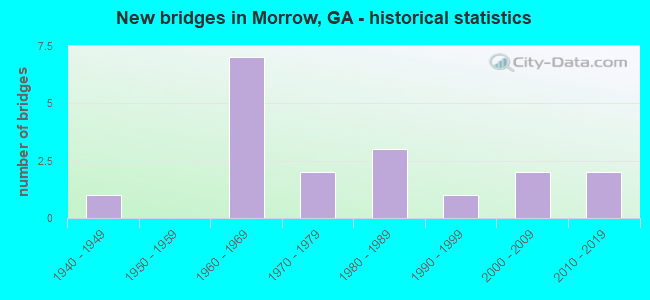
- New bridges - historical statistics
- 11940-1949
- 71960-1969
- 21970-1979
- 31980-1989
- 11990-1999
- 22000-2009
- 22010-2019


- Bridge Condition - Superstructure
- 11.1%Very good
- 88.9%Good

- Bridge Condition - Substructure
- 33.3%Very good
- 66.7%Good

- Bridge Condition - Channel
- 33.3%Very good
- 50.0%Good
- 16.7%Satisfactory

- Bridge Condition - Culverts
- 77.8%Good
- 22.2%Satisfactory
Find on map >> Show street view
Structure Number: 630009, Location: 3 MI E OF MORROW (Lat: 33.588108, Lng: -84.293108), Route carried "on" structure: US 23, Year Built: 1944, Status: Open, Structure Length: 0.70m (2.30ft), Average Daily Traffic: 11,140 (year 2012), Truck Traffic: 1%, Average Future Daily Traffic: 16,710 (year 2032), Design Load: H 15, Features Intersected: TAR CREEK
Minimum Vertical Clearance: 30+ m (98+ ft), Kilometerpoint: 3.219, Lanes on structure: 2, Base Highway Network: Yes, Owner: State Highway Agency, Approaching Roadway Width: 8.5m (27.9ft), Material/Design: Concrete, Design/Construction: Culvert, Number Of Spans In Main Unit: 3, Length of Maximum Span: 2.1m (6.9ft)
Condition: Channel: Good, Culverts: Satisfactory, Operating Rating: 37.1 metric tons, Method Used To Determine Operating Rating: Load Factor (LF), Inventory Rating: 22.6 metric tons, Method Used To Determine Inventory Rating: Load Factor (LF), Structural Evaluation: Somewhat better than minimum adequacy, Waterway Adequacy: Equal to present desirable criteria, Approach Roadway Alignment: Equal to present desirable criteria, Designated Inspection Frequency: Every 24 months, Inspection Date: April 2021
Find on map >> Show street view
Structure Number: 630031, Location: 1.75 MI N OF HENRY CO LIN (Lat: 33.559553, Lng: -84.311122), Route carried "on" structure: Interstate 75, Year Built: 1969, Year Reconstructed: 1991, Status: Open, Structure Length: 13.44m (44.09ft), Average Daily Traffic: 116,910 (year 2012), Truck Traffic: 1%, Average Future Daily Traffic: 175,365 (year 2032), Design Load: HS 20+Mod, Features Intersected: M-9109 MT ZION ROAD
Minimum Vertical Clearance: 30+ m (98+ ft), Kilometerpoint: 370.149, Lanes on structure: 8, Lanes under structure: 2, Base Highway Network: Yes, Owner: State Highway Agency, Approaching Roadway Width: 39.3m (128.9ft), Skew: 34 degrees, Material/Design: Steel, Design/Construction: Stringer/Multi-beam, Number Of Spans In Main Unit: 7, Length of Maximum Span: 22.9m (75.1ft), Curb-To-Curb Width: 39.4m (129.3ft), Out-to-Out Width: 40.1m (131.6ft)
Condition: Deck: Good, Superstructure: Good, Substructure: Good, Operating Rating: 29.0 metric tons, Method Used To Determine Operating Rating: Load Factor (LF), Inventory Rating: 17.2 metric tons, Method Used To Determine Inventory Rating: Load Factor (LF), Structural Evaluation: Meets minimum limits, Deck Geometry: Superior to present desirable criteria, Underclear: Equal to present minimum criteria, Approach Roadway Alignment: Better than present minimum criteria, Designated Inspection Frequency: Every 24 months, Inspection Date: May 2021, Deck Structure Type: Concrete Cast-file-Place
Find on map >> Show street view
Structure Number: 630033, Location: 0.7 MI S OF SR 54 (Lat: 33.573928, Lng: -84.333681), Route carried "on" structure: Interstate 75, Year Built: 1969, Year Reconstructed: 1991, Status: Open, Structure Length: 3.75m (12.30ft), Average Daily Traffic: 128,280 (year 2012), Truck Traffic: 1%, Average Future Daily Traffic: 192,420 (year 2032), Design Load: HS 20+Mod, Features Intersected: CR 1110 MEADOWBROOKS DR
Minimum Vertical Clearance: 30+ m (98+ ft), Kilometerpoint: 373.368, Lanes on structure: 10, Lanes under structure: 2, Base Highway Network: Yes, Owner: State Highway Agency, Approaching Roadway Width: 39.6m (129.9ft), Skew: 30 degrees, Material/Design: Steel, Design/Construction: Stringer/Multi-beam, Number Of Spans In Main Unit: 3, Length of Maximum Span: 15.8m (51.8ft), Curb-To-Curb Width: 65.1m (213.6ft), Out-to-Out Width: 67.0m (219.8ft)
Condition: Deck: Good, Superstructure: Good, Substructure: Good, Operating Rating: 34.4 metric tons, Method Used To Determine Operating Rating: Load Factor (LF), Inventory Rating: 20.8 metric tons, Method Used To Determine Inventory Rating: Load Factor (LF), Structural Evaluation: Somewhat better than minimum adequacy, Deck Geometry: Superior to present desirable criteria, Underclear: Equal to present minimum criteria, Approach Roadway Alignment: Equal to present desirable criteria, Designated Inspection Frequency: Every 24 months, Inspection Date: May 2021, Deck Structure Type: Concrete Cast-file-Place
Find on map >> Show street view
Structure Number: 630035, Location: 0.5 MI N OF SR 54 (Lat: 33.578550, Lng: -84.349411), Route carried "on" structure: Interstate 75, Year Built: 1965, Status: Open, Structure Length: 0.85m (2.79ft), Average Daily Traffic: 143,670 (year 2012), Truck Traffic: 1%, Average Future Daily Traffic: 215,505 (year 2032), Design Load: HS 20+Mod, Features Intersected: JESTER CREEK TRIB.
Minimum Vertical Clearance: 30+ m (98+ ft), Kilometerpoint: 374.977, Lanes on structure: 11, Base Highway Network: Yes, Owner: State Highway Agency, Approaching Roadway Width: 46.6m (152.9ft), Skew: 31 degrees, Material/Design: Concrete, Design/Construction: Culvert, Number Of Spans In Main Unit: 4, Length of Maximum Span: 1.8m (5.9ft)
Condition: Channel: Good, Culverts: Good, Structural Evaluation: Better than present minimum criteria, Waterway Adequacy: Superior to present desirable criteria, Approach Roadway Alignment: Equal to present desirable criteria, Designated Inspection Frequency: Every 24 months, Inspection Date: June 2021
Find on map >> Show street view
Structure Number: 630036, Location: 0.75 MI N OF SR 54 (Lat: 33.579347, Lng: -84.353022), Route carried "on" structure: Interstate 75, Year Built: 1965, Status: Open, Structure Length: 0.64m (2.10ft), Average Daily Traffic: 143,670 (year 2012), Truck Traffic: 1%, Average Future Daily Traffic: 215,505 (year 2032), Design Load: HS 20+Mod, Features Intersected: JESTER CREEK
Minimum Vertical Clearance: 30+ m (98+ ft), Kilometerpoint: 374.977, Lanes on structure: 10, Base Highway Network: Yes, Owner: State Highway Agency, Approaching Roadway Width: 39.9m (130.9ft), Skew: 30 degrees, Material/Design: Concrete, Design/Construction: Culvert, Number Of Spans In Main Unit: 3, Length of Maximum Span: 1.8m (5.9ft)
Condition: Channel: Good, Culverts: Good, Structural Evaluation: Better than present minimum criteria, Waterway Adequacy: Superior to present desirable criteria, Approach Roadway Alignment: Equal to present desirable criteria, Designated Inspection Frequency: Every 24 months, Inspection Date: June 2021
Find on map >> Show street view
Structure Number: 630075, Location: IN MORROW (Lat: 33.583350, Lng: -84.346019), Route carried "on" structure: City street 9077, Year Built: 1965, Status: Open, Structure Length: 1.25m (4.10ft), Average Daily Traffic: 8,460 (year 2012), Truck Traffic: 1%, Average Future Daily Traffic: 12,690 (year 2032), Features Intersected: JESTERS CREEK TRIB., Facility Carried by Structure: MORROW ROAD
Minimum Vertical Clearance: 30+ m (98+ ft), Kilometerpoint: 9.656, Lanes on structure: 2, Base Highway Network: Yes, Owner: County Highway Agency, Approaching Roadway Width: 9.1m (29.9ft), Material/Design: Steel, Design/Construction: Stringer/Multi-beam, Number Of Spans In Main Unit: 1, Length of Maximum Span: 12.5m (41.0ft), Curb or Sidewalk Widths: Left: 1.0m (3.3ft), Right: 1.0m (3.3ft), Curb-To-Curb Width: 9.1m (29.9ft), Out-to-Out Width: 11.6m (38.1ft)
Condition: Deck: Good, Superstructure: Good, Substructure: Good, Channel: Good, Operating Rating: 43.5 metric tons, Method Used To Determine Operating Rating: Load Factor (LF), Inventory Rating: 26.3 metric tons, Method Used To Determine Inventory Rating: Load Factor (LF), Structural Evaluation: Equal to present minimum criteria, Deck Geometry: High priority of corrective action, Waterway Adequacy: Equal to present desirable criteria, Approach Roadway Alignment: Equal to present desirable criteria, Length Of Structure Improvement: 7.68m (25.20ft), Designated Inspection Frequency: Every 24 months, Inspection Date: March 2021, Bridge Improvement Cost: $51,000, Roadway Improvement Cost: $53,000, Total Project Cost: $128,000, Deck Structure Type: Concrete Cast-file-Place, Wearing Surface/Protective System: Wearing Surface: Bituminous
Find on map >> Show street view
Structure Number: 630083, Location: 1 MI E OF MORROW (Lat: 33.572128, Lng: -84.307969), Route carried "on" structure: City street 9108, Year Built: 1969, Status: Open, Structure Length: 0.64m (2.10ft), Average Daily Traffic: 22,210 (year 2012), Truck Traffic: 1%, Average Future Daily Traffic: 33,315 (year 2032), Design Load: HS 20+Mod, Features Intersected: PANTHER CREEK, Facility Carried by Structure: MT. ZION BOULEVARD
Minimum Vertical Clearance: 30+ m (98+ ft), Kilometerpoint: 6.437, Lanes on structure: 2, Base Highway Network: Yes, Owner: County Highway Agency, Approaching Roadway Width: 6.7m (22.0ft), Material/Design: Concrete, Design/Construction: Culvert, Number Of Spans In Main Unit: 2, Length of Maximum Span: 3.0m (9.8ft)
Condition: Channel: Satisfactory, Culverts: Satisfactory, Operating Rating: 41.7 metric tons, Method Used To Determine Operating Rating: Field evaluation and documented engineering judgment, Inventory Rating: 24.4 metric tons, Method Used To Determine Inventory Rating: Field evaluation and documented engineering judgment, Structural Evaluation: Equal to present minimum criteria, Waterway Adequacy: Equal to present desirable criteria, Approach Roadway Alignment: Equal to present desirable criteria, Designated Inspection Frequency: Every 24 months, Inspection Date: March 2021
Find on map >> Show street view
Structure Number: 630084, Location: 0.5 MI W OF MORROW (Lat: 33.572775, Lng: -84.364981), Route carried "on" structure: City street 9109, Year Built: 1972, Status: Open, Structure Length: 0.79m (2.59ft), Average Daily Traffic: 18,050 (year 2012), Truck Traffic: 1%, Average Future Daily Traffic: 27,075 (year 2032), Design Load: HS 20+Mod, Features Intersected: JESTERS CREEK TRIB., Facility Carried by Structure: MORROW IND BLVD
Minimum Vertical Clearance: 30+ m (98+ ft), Kilometerpoint: 0.000, Lanes on structure: 5, Base Highway Network: Yes, Owner: County Highway Agency, Approaching Roadway Width: 19.5m (64.0ft), Material/Design: Concrete, Design/Construction: Culvert, Number Of Spans In Main Unit: 3, Length of Maximum Span: 2.4m (7.9ft), Curb or Sidewalk Widths: Left: 1.2m (3.9ft), Right: 1.2m (3.9ft)
Condition: Channel: Satisfactory, Culverts: Good, Operating Rating: 55.3 metric tons, Method Used To Determine Operating Rating: Field evaluation and documented engineering judgment, Inventory Rating: 32.6 metric tons, Method Used To Determine Inventory Rating: Field evaluation and documented engineering judgment, Structural Evaluation: Better than present minimum criteria, Waterway Adequacy: Equal to present minimum criteria, Approach Roadway Alignment: Equal to present desirable criteria, Designated Inspection Frequency: Every 24 months, Underwater Inspection Frequency: Every 60 months, Inspection Date: April 2021, Underwater Inspection Date: January 2019
Find on map >> Show street view
Structure Number: 630085, Location: IN MORROW (Lat: 33.572278, Lng: -84.357758), Route carried "on" structure: City street 9109, Year Built: 1976, Status: Open, Structure Length: 0.98m (3.22ft), Average Daily Traffic: 18,050 (year 2012), Truck Traffic: 1%, Average Future Daily Traffic: 27,075 (year 2032), Design Load: HS 20+Mod, Features Intersected: JESTERS CREEK, Facility Carried by Structure: MORROW IND BLVD
Minimum Vertical Clearance: 30+ m (98+ ft), Kilometerpoint: 1.609, Lanes on structure: 5, Base Highway Network: Yes, Owner: County Highway Agency, Approaching Roadway Width: 19.5m (64.0ft), Material/Design: Concrete, Design/Construction: Culvert, Number Of Spans In Main Unit: 4, Length of Maximum Span: 2.1m (6.9ft), Curb or Sidewalk Widths: Left: 1.4m (4.6ft), Right: 1.4m (4.6ft)
Condition: Channel: Good, Culverts: Good, Operating Rating: 55.3 metric tons, Method Used To Determine Operating Rating: Field evaluation and documented engineering judgment, Inventory Rating: 32.6 metric tons, Method Used To Determine Inventory Rating: Field evaluation and documented engineering judgment, Structural Evaluation: Better than present minimum criteria, Waterway Adequacy: Equal to present desirable criteria, Approach Roadway Alignment: Equal to present desirable criteria, Designated Inspection Frequency: Every 24 months, Inspection Date: April 2021
Find on map >> Show street view
Structure Number: 630122, Location: 3 MI E OF MORROW CTY LMTS (Lat: 33.590478, Lng: -84.282108), Route carried "on" structure: City street 9110, Year Built: 1984, Status: Open, Structure Length: 9.66m (31.69ft), Average Daily Traffic: 8,420 (year 2012), Truck Traffic: 1%, Average Future Daily Traffic: 12,630 (year 2032), Design Load: HS 20+Mod, Features Intersected: I-675 (SR 413), Facility Carried by Structure: REX ROAD
Minimum Vertical Clearance: 30+ m (98+ ft), Kilometerpoint: 1.609, Lanes on structure: 2, Lanes under structure: 4, Base Highway Network: Yes, Owner: State Highway Agency, Approaching Roadway Width: 9.8m (32.2ft), Skew: 1 degrees, Material/Design: Prestressed concrete continuous, Design/Construction: Box Beam or Girders - Single/Spread, Number Of Spans In Main Unit: 2, Length of Maximum Span: 50.3m (165.0ft), Curb-To-Curb Width: 13.4m (44.0ft), Out-to-Out Width: 14.4m (47.2ft)
Condition: Deck: Good, Superstructure: Good, Substructure: Good, Operating Rating: 46.2 metric tons, Method Used To Determine Operating Rating: Allowable Stress (AS), Inventory Rating: 32.6 metric tons, Method Used To Determine Inventory Rating: Allowable Stress (AS), Structural Evaluation: Better than present minimum criteria, Deck Geometry: Equal to present minimum criteria, Underclear: Superior to present desirable criteria, Approach Roadway Alignment: Equal to present desirable criteria, Designated Inspection Frequency: Every 24 months, Inspection Date: June 2021, Deck Structure Type: Concrete Cast-file-Place, Wearing Surface/Protective System: Wearing Surface: Epoxy Overlay
Find on map >> Show street view
Structure Number: 630128, Location: 2.5 MI E OF MORROW C.L. (Lat: 33.586447, Lng: -84.280869), Route carried "on" structure: Interstate 675, Year Built: 1984, Status: Open, Structure Length: 1.37m (4.49ft), Average Daily Traffic: 62,080 (year 2012), Truck Traffic: 1%, Average Future Daily Traffic: 93,120 (year 2032), Design Load: HS 20+Mod, Features Intersected: TAR CREEK
Minimum Vertical Clearance: 30+ m (98+ ft), Kilometerpoint: 4.828, Lanes on structure: 4, Base Highway Network: Yes, Owner: State Highway Agency, Approaching Roadway Width: 24.4m (80.1ft), Skew: 13 degrees, Material/Design: Concrete, Design/Construction: Culvert, Number Of Spans In Main Unit: 4, Length of Maximum Span: 3.0m (9.8ft)
Condition: Channel: Good, Culverts: Good, Structural Evaluation: Better than present minimum criteria, Waterway Adequacy: Equal to present desirable criteria, Approach Roadway Alignment: Equal to present desirable criteria, Designated Inspection Frequency: Every 24 months, Inspection Date: April 2021
Find on map >> Show street view
Structure Number: 630135, Location: 2.5 MI N OF HENRY CO LINE (Lat: 33.564906, Lng: -84.320106), Route carried "on" structure: City street 9108, Year Built: 1989, Status: Open, Structure Length: 9.75m (31.99ft), Average Daily Traffic: 31,980 (year 2012), Truck Traffic: 1%, Average Future Daily Traffic: 47,970 (year 2032), Design Load: HS 20+Mod, Features Intersected: I-75 & (2) I-75 RAMPS, Facility Carried by Structure: MT ZION BOULEVARD
Minimum Vertical Clearance: 30+ m (98+ ft), Kilometerpoint: 6.437, Lanes on structure: 5, Lanes under structure: 10, Base Highway Network: Yes, Owner: State Highway Agency, Approaching Roadway Width: 20.7m (67.9ft), Skew: 20 degrees, Material/Design: Prestressed concrete, Design/Construction: Stringer/Multi-beam, Number Of Spans In Main Unit: 4, Length of Maximum Span: 37.5m (123.0ft), Curb-To-Curb Width: 26.8m (87.9ft), Out-to-Out Width: 27.8m (91.2ft)
Condition: Deck: Good, Superstructure: Good, Substructure: Good, Operating Rating: 46.2 metric tons, Method Used To Determine Operating Rating: Allowable Stress (AS), Inventory Rating: 32.6 metric tons, Method Used To Determine Inventory Rating: Allowable Stress (AS), Structural Evaluation: Better than present minimum criteria, Deck Geometry: Superior to present desirable criteria, Underclear: Somewhat better than minimum adequacy, Approach Roadway Alignment: Equal to present desirable criteria, Designated Inspection Frequency: Every 24 months, Inspection Date: May 2021, Deck Structure Type: Concrete Cast-file-Place
Find on map >> Show street view
Structure Number: 635012, Location: IN MORROW (Lat: 33.592769, Lng: -84.342797), Route carried "on" structure: City street 311, Year Built: 1964, Status: Open, Structure Length: 1.22m (4.00ft), Average Daily Traffic: 2,200 (year 2012), Truck Traffic: 1%, Average Future Daily Traffic: 3,300 (year 2032), Features Intersected: JESTERS CREEK TRIB., Facility Carried by Structure: REYNOLDS ROAD
Minimum Vertical Clearance: 30+ m (98+ ft), Kilometerpoint: 0.000, Lanes on structure: 2, Base Highway Network: Yes, Owner: County Highway Agency, Approaching Roadway Width: 6.1m (20.0ft), Material/Design: Steel, Design/Construction: Stringer/Multi-beam, Number Of Spans In Main Unit: 1, Length of Maximum Span: 12.2m (40.0ft), Curb or Sidewalk Widths: Left: 0.0m, Right: 1.2m (3.9ft), Curb-To-Curb Width: 8.0m (26.2ft), Out-to-Out Width: 9.5m (31.2ft)
Condition: Deck: Good, Superstructure: Good, Substructure: Good, Channel: Very good, Operating Rating: 37.1 metric tons, Method Used To Determine Operating Rating: Load Factor (LF), Inventory Rating: 22.6 metric tons, Method Used To Determine Inventory Rating: Load Factor (LF), Structural Evaluation: Equal to present minimum criteria, Deck Geometry: High priority of corrective action, Waterway Adequacy: Better than present minimum criteria, Approach Roadway Alignment: Better than present minimum criteria, Designated Inspection Frequency: Every 24 months, Inspection Date: March 2021, Deck Structure Type: Concrete Cast-file-Place, Wearing Surface/Protective System: Wearing Surface: Bituminous
Find on map >> Show street view
Structure Number: 635041, Location: IN MORROW (Lat: 33.588408, Lng: -84.357378), Route carried "on" structure: City street 9077, Year Built: 1996, Status: Open, Structure Length: 0.70m (2.30ft), Average Daily Traffic: 8,460 (year 2012), Truck Traffic: 1%, Average Future Daily Traffic: 12,690 (year 2032), Design Load: HS 20+Mod, Features Intersected: JESTERS CREEK, Facility Carried by Structure: MORROW ROAD
Minimum Vertical Clearance: 30+ m (98+ ft), Kilometerpoint: 9.656, Lanes on structure: 3, Base Highway Network: Yes, Owner: County Highway Agency, Approaching Roadway Width: 10.4m (34.1ft), Skew: 2 degrees, Material/Design: Concrete, Design/Construction: Culvert, Number Of Spans In Main Unit: 2, Length of Maximum Span: 3.4m (11.2ft), Curb or Sidewalk Widths: Left: 0.0m, Right: 1.5m (4.9ft)
Condition: Channel: Very good, Culverts: Good, Operating Rating: 55.3 metric tons, Method Used To Determine Operating Rating: Field evaluation and documented engineering judgment, Inventory Rating: 32.6 metric tons, Method Used To Determine Inventory Rating: Field evaluation and documented engineering judgment, Structural Evaluation: Better than present minimum criteria, Waterway Adequacy: Equal to present desirable criteria, Approach Roadway Alignment: Better than present minimum criteria, Designated Inspection Frequency: Every 24 months, Inspection Date: April 2021
Find on map >> Show street view
Structure Number: 635053, Location: 1 MI E OF MORROW (Lat: 33.572658, Lng: -84.310889), Route carried "on" structure: County highway 38, Year Built: 2003, Status: Open, Structure Length: 1.65m (5.41ft), Average Daily Traffic: 14,540 (year 2012), Truck Traffic: 1%, Average Future Daily Traffic: 21,810 (year 2032), Design Load: HS 20+Mod, Features Intersected: PANTHER CREEK, Facility Carried by Structure: MADDOX ROAD
Minimum Vertical Clearance: 30+ m (98+ ft), Kilometerpoint: 3.219, Lanes on structure: 2, Base Highway Network: Yes, Owner: County Highway Agency, Approaching Roadway Width: 6.1m (20.0ft), Material/Design: Concrete, Design/Construction: Culvert, Number Of Spans In Main Unit: 5, Length of Maximum Span: 3.0m (9.8ft)
Condition: Channel: Very good, Culverts: Good, Operating Rating: 55.3 metric tons, Method Used To Determine Operating Rating: Field evaluation and documented engineering judgment, Inventory Rating: 32.6 metric tons, Method Used To Determine Inventory Rating: Field evaluation and documented engineering judgment, Structural Evaluation: Better than present minimum criteria, Waterway Adequacy: Equal to present desirable criteria, Approach Roadway Alignment: Superior to present desirable criteria, Designated Inspection Frequency: Every 24 months, Inspection Date: March 2021
Find on map >> Show street view
Structure Number: 635069, Location: 2.5 MI NE OF JONESBORO (Lat: 33.553528, Lng: -84.316697), Route carried "on" structure: County highway 1340, Year Built: 2008, Status: Open, Structure Length: 1.89m (6.20ft), Average Daily Traffic: 20,760 (year 2012), Truck Traffic: 1%, Average Future Daily Traffic: 31,140 (year 2032), Design Load: HS 20+Mod, Features Intersected: REEVES CREEK, Facility Carried by Structure: CONKLE ROAD
Minimum Vertical Clearance: 30+ m (98+ ft), Kilometerpoint: 1.609, Lanes on structure: 2, Base Highway Network: Yes, Owner: County Highway Agency, Approaching Roadway Width: 8.5m (27.9ft), Skew: 1 degrees, Material/Design: Prestressed concrete, Design/Construction: Stringer/Multi-beam, Number Of Spans In Main Unit: 1, Length of Maximum Span: 18.9m (62.0ft), Curb or Sidewalk Widths: Left: 1.8m (5.9ft), Right: 1.8m (5.9ft), Curb-To-Curb Width: 8.5m (27.9ft), Out-to-Out Width: 12.8m (42.0ft)
Condition: Deck: Good, Superstructure: Very good, Substructure: Very good, Channel: Very good, Operating Rating: 66.2 metric tons, Method Used To Determine Operating Rating: Load Factor (LF), Inventory Rating: 29.9 metric tons, Method Used To Determine Inventory Rating: Load Factor (LF), Structural Evaluation: Better than present minimum criteria, Deck Geometry: High priority of replacement, Waterway Adequacy: Equal to present desirable criteria, Approach Roadway Alignment: Equal to present desirable criteria, Designated Inspection Frequency: Every 24 months, Inspection Date: April 2021, Deck Structure Type: Concrete Cast-file-Place
Find on map >> Show street view
Structure Number: 635074, Location: IN MORROW (Lat: 33.576581, Lng: -84.340767), Route carried "on" structure: City street 11681, Year Built: 2011, Status: Open, Structure Length: 9.63m (31.59ft), Average Daily Traffic: 24,960 (year 2012), Truck Traffic: 1%, Average Future Daily Traffic: 37,440 (year 2032), Design Load: HS 20+Mod, Features Intersected: I-75, Facility Carried by Structure: LEE STREET
Minimum Vertical Clearance: 6.42m (21.06ft), Kilometerpoint: 0.000, Lanes on structure: 2, Lanes under structure: 11, Base Highway Network: Yes, Owner: State Highway Agency, Approaching Roadway Width: 8.5m (27.9ft), Material/Design: Prestressed concrete, Design/Construction: Stringer/Multi-beam, Number Of Spans In Main Unit: 4, Length of Maximum Span: 31.4m (103.0ft), Curb or Sidewalk Widths: Left: 1.8m (5.9ft), Right: 1.8m (5.9ft), Curb-To-Curb Width: 14.6m (47.9ft), Out-to-Out Width: 19.0m (62.3ft)
Condition: Deck: Good, Superstructure: Good, Substructure: Very good, Operating Rating: 68.0 metric tons, Method Used To Determine Operating Rating: Load Factor (LF), Inventory Rating: 31.7 metric tons, Method Used To Determine Inventory Rating: Load Factor (LF), Structural Evaluation: Better than present minimum criteria, Deck Geometry: Superior to present desirable criteria, Underclear: High priority of corrective action, Approach Roadway Alignment: Equal to present desirable criteria, Designated Inspection Frequency: Every 24 months, Inspection Date: May 2021, Deck Structure Type: Concrete Cast-file-Place
Find on map >> Show street view
Structure Number: 635075, Location: IN MORROW (Lat: 33.576722, Lng: -84.341367), Route carried "on" structure: State highway 54, Year Built: 2011, Status: Open, Structure Length: 9.78m (32.09ft), Average Daily Traffic: 24,960 (year 2012), Truck Traffic: 1%, Average Future Daily Traffic: 37,440 (year 2032), Design Load: HS 20+Mod, Features Intersected: I-75
Minimum Vertical Clearance: 30+ m (98+ ft), Kilometerpoint: 12.875, Lanes on structure: 8, Lanes under structure: 11, Base Highway Network: Yes, Owner: State Highway Agency, Approaching Roadway Width: 39.0m (128.0ft), Skew: 20 degrees, Material/Design: Prestressed concrete, Design/Construction: Stringer/Multi-beam, Number Of Spans In Main Unit: 4, Length of Maximum Span: 31.4m (103.0ft), Curb or Sidewalk Widths: Left: 4.3m (14.1ft), Right: 1.8m (5.9ft), Curb-To-Curb Width: 32.9m (107.9ft), Out-to-Out Width: 39.8m (130.6ft)
Condition: Deck: Good, Superstructure: Good, Substructure: Very good, Operating Rating: 36.2 metric tons, Method Used To Determine Operating Rating: Load Factor (LF), Inventory Rating: 21.7 metric tons, Method Used To Determine Inventory Rating: Load Factor (LF), Structural Evaluation: Somewhat better than minimum adequacy, Deck Geometry: Somewhat better than minimum adequacy, Underclear: Equal to present minimum criteria, Approach Roadway Alignment: Equal to present desirable criteria, Designated Inspection Frequency: Every 24 months, Inspection Date: May 2021, Deck Structure Type: Concrete Cast-file-Place
Find on map >> Show street view
Structure Number: 630031, Location: 1.75 MI N OF HENRY CO LIN (Lat: 33.559553, Lng: -84.311122), Route carried "under" structure: City street 9109, Structure Length: 0. m, Average Daily Traffic: 8,200 (year 2010), Truck Traffic: 1%, Features Intersected: I-75, Facility Carried by Structure: I-75
Minimum Vertical Clearance: 5.28m (17.32ft), Kilometerpoint: 6.437, Lanes on structure: 8, Length of Maximum Span: 0.0m
Find on map >> Show street view
Structure Number: 630033, Location: 0.7 MI S OF SR 54 (Lat: 33.573928, Lng: -84.333681), Route carried "under" structure: County highway 1110, Structure Length: 0. m, Average Daily Traffic: 3,000 (year 2009), Truck Traffic: 1%, Features Intersected: I-75, Facility Carried by Structure: I-75
Minimum Vertical Clearance: 5.15m (16.90ft), Kilometerpoint: 0.000, Lanes on structure: 10, Length of Maximum Span: 0.0m
Find on map >> Show street view
Structure Number: 630122, Location: 3 MI E OF MORROW CTY LMTS (Lat: 33.590478, Lng: -84.282108), Route carried "under" structure: Interstate 675, Structure Length: 0. m, Average Daily Traffic: 42,800 (year 2009), Truck Traffic: 1%, Features Intersected: M-9110 REX ROAD, Facility Carried by Structure: REX ROAD
Minimum Vertical Clearance: 6.55m (21.49ft), Kilometerpoint: 6.437, Lanes on structure: 2, Length of Maximum Span: 0.0m
Find on map >> Show street view
Structure Number: 630135, Location: 2.5 MI N OF HENRY CO LINE (Lat: 33.564906, Lng: -84.320106), Route carried "under" structure: Interstate 75, Structure Length: 0. m, Average Daily Traffic: 43,900 (year 2009), Truck Traffic: 1%, Features Intersected: M-9108 MT ZION BLVD., Facility Carried by Structure: MT ZION BOULEVARD
Minimum Vertical Clearance: 5.20m (17.06ft), Kilometerpoint: 371.759, Lanes on structure: 5, Length of Maximum Span: 0.0m
Find on map >> Show street view
Structure Number: 630135, Location: 2.5 MI N OF HENRY CO LINE (Lat: 33.564906, Lng: -84.320106), Route carried "under" structure: Ramp Interstate 75, Structure Length: 0. m, Average Daily Traffic: 1,000 (year 1999), Truck Traffic: 1%, Features Intersected: M-9108 MT ZION BLVD., Facility Carried by Structure: MT ZION BOULEVARD
Minimum Vertical Clearance: 5.00m (16.40ft), Kilometerpoint: 371.759, Lanes on structure: 5, Length of Maximum Span: 0.0m
Find on map >> Show street view
Structure Number: 630135, Location: 2.5 MI N OF HENRY CO LINE (Lat: 33.564906, Lng: -84.320106), Route carried "under" structure: Ramp Interstate 75, Structure Length: 0. m, Average Daily Traffic: 80,800 (year 1999), Truck Traffic: 1%, Features Intersected: M-9108 MT ZION BLVD., Facility Carried by Structure: MT ZION BOULEVARD
Minimum Vertical Clearance: 5.51m (18.08ft), Kilometerpoint: 371.759, Lanes on structure: 5, Length of Maximum Span: 0.0m
Find on map >> Show street view
Structure Number: 635074, Location: IN MORROW (Lat: 33.576581, Lng: -84.340767), Route carried "under" structure: Ramp Interstate 75, Structure Length: 0. m, Average Daily Traffic: 5,000 (year 2011), Truck Traffic: 1%, Features Intersected: LEE STREET, Facility Carried by Structure: LEE STREET
Minimum Vertical Clearance: 6.42m (21.06ft), Kilometerpoint: 373.368, Lanes on structure: 2, Length of Maximum Span: 0.0m
Find on map >> Show street view
Structure Number: 635074, Location: IN MORROW (Lat: 33.576581, Lng: -84.340767), Route carried "under" structure: Ramp State highway 11681, Structure Length: 0. m, Average Daily Traffic: 5,000 (year 2011), Truck Traffic: 5%, Features Intersected: LEE STREET, Facility Carried by Structure: LEE STREET
Minimum Vertical Clearance: 6.42m (21.06ft), Kilometerpoint: 12.875, Lanes on structure: 2, Length of Maximum Span: 0.0m
Find on map >> Show street view
Structure Number: 635074, Location: IN MORROW (Lat: 33.576581, Lng: -84.340767), Route carried "under" structure: Interstate 75, Structure Length: 0. m, Average Daily Traffic: 109,800 (year 2007), Truck Traffic: 5%, Features Intersected: LEE STREET, Facility Carried by Structure: LEE STREET
Minimum Vertical Clearance: 6.42m (21.06ft), Kilometerpoint: 373.368, Lanes on structure: 2, Length of Maximum Span: 0.0m
Find on map >> Show street view
Structure Number: 635075, Location: IN MORROW (Lat: 33.576722, Lng: -84.341367), Route carried "under" structure: Ramp State highway 54, Structure Length: 0. m, Average Daily Traffic: 5,000 (year 2011), Truck Traffic: 5%, Features Intersected: SR54
Minimum Vertical Clearance: 5.89m (19.32ft), Kilometerpoint: 12.875, Lanes on structure: 8, Length of Maximum Span: 0.0m
Find on map >> Show street view
Structure Number: 635075, Location: IN MORROW (Lat: 33.576722, Lng: -84.341367), Route carried "under" structure: Interstate 75, Structure Length: 0. m, Average Daily Traffic: 109,800 (year 2009), Truck Traffic: 5%, Features Intersected: SR054, Facility Carried by Structure: SR 54
Minimum Vertical Clearance: 5.89m (19.32ft), Kilometerpoint: 373.368, Lanes on structure: 8, Length of Maximum Span: 0.0m
Find on map >> Show street view
Structure Number: 635075, Location: IN MORROW (Lat: 33.576722, Lng: -84.341367), Route carried "under" structure: Ramp Interstate 75, Structure Length: 0. m, Average Daily Traffic: 5,000 (year 2011), Truck Traffic: 5%, Features Intersected: SR054, Facility Carried by Structure: SR 54
Minimum Vertical Clearance: 5.89m (19.32ft), Kilometerpoint: 373.368, Lanes on structure: 8, Length of Maximum Span: 0.0m
Find on map >> Show street view
Structure Number: 635078, Location: 2.35 MILES SOUTH OF JCT (Lat: 33.576617, Lng: -84.340936), Route carried "under" structure: Interstate 401, Structure Length: 0. m, Average Daily Traffic: 163,303 (year 2010), Truck Traffic: 1%, Features Intersected: I-75, Facility Carried by Structure: NORFOLK SOUTHERN R
Minimum Vertical Clearance: 5.76m (18.90ft), Kilometerpoint: 373.368, Length of Maximum Span: 0.0m