Bridge Statistics for Moody, Alabama (AL)
Condition, Traffic, Stress, Structural Evaluation, Project Costs
- National Bridge Inventory (NBI) Statistics
- 26Number of bridges
- 243ft / 74.2mTotal length
- $42,666,000Total costs
- 383,310Total average daily traffic
- 80,388Total average daily truck traffic
- National Bridge Inventory (NBI) Registered Bridges for Moody
- No street view available for this location
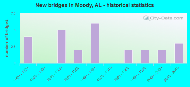
- New bridges - historical statistics
- 41920-1929
- 51940-1949
- 21950-1959
- 61960-1969
- 21980-1989
- 21990-1999
- 22000-2009
- 32010-2019

- Reconstructed bridges - Historical Statistics
- 11980-1989
- 11990-1999
- 02000-2009
- 12010-2019


- Bridge Condition - Deck
- 9.1%Very good
- 27.3%Good
- 54.5%Satisfactory
- 9.1%Fair

- Bridge Condition - Superstructure
- 9.1%Very good
- 36.4%Good
- 36.4%Satisfactory
- 18.2%Fair

- Bridge Condition - Substructure
- 18.2%Good
- 63.6%Satisfactory
- 18.2%Fair

- Bridge Condition - Channel
- 6.3%Very good
- 50.0%Good
- 37.5%Satisfactory
- 6.3%Fair

- Bridge Condition - Culverts
- 50.0%Good
- 40.0%Satisfactory
- 10.0%Fair
Find on map >> Show street view
Structure Number: 171, Location: IN MOODY (Lat: 33.559469, Lng: -86.500261), Route carried "on" structure: US 78, Year Built: 1928, Status: Open, Structure Length: 4.51m (14.80ft), Average Daily Traffic: 4,100 (year 2020), Truck Traffic: 9%, Average Future Daily Traffic: 5,288 (year 2040), Design Load: H 15, Features Intersected: NORFOLK SOUTHERN
Minimum Vertical Clearance: 30+ m (98+ ft), Kilometerpoint: 189.998, Lanes on structure: 2, Owner: State Highway Agency, Approaching Roadway Width: 7.3m (24.0ft), Material/Design: Concrete, Design/Construction: Tee Beam, Number Of Spans In Main Unit: 5, Length of Maximum Span: 15.2m (49.9ft), Curb-To-Curb Width: 7.1m (23.3ft), Out-to-Out Width: 7.6m (24.9ft)
Condition: Deck: Fair, Superstructure: Fair, Substructure: Satisfactory, Operating Rating: 44.4 metric tons, Method Used To Determine Operating Rating: Load Factor (LF), Inventory Rating: 26.6 metric tons, Method Used To Determine Inventory Rating: Load Factor (LF), Structural Evaluation: Somewhat better than minimum adequacy, Deck Geometry: High priority of replacement, Underclear: Equal to present minimum criteria, Approach Roadway Alignment: Equal to present minimum criteria, Length Of Structure Improvement: 5.50m (18.04ft), Designated Inspection Frequency: Every 24 months, Inspection Date: March 2020, Bridge Improvement Cost: $906,000, Roadway Improvement Cost: $91,000, Total Project Cost: $997,000 ( Estimate for 2022), Deck Structure Type: Concrete Cast-file-Place, Wearing Surface/Protective System: Wearing Surface: Bituminous
Find on map >> Show street view
Structure Number: 473, Location: US 78 * N/S RR (Lat: 33.573300, Lng: -86.451867), Route carried "on" structure: US 78, Year Built: 1928, Status: Open, Structure Length: 1.28m (4.20ft), Average Daily Traffic: 3,170 (year 2021), Truck Traffic: 3%, Average Future Daily Traffic: 4,088 (year 2041), Design Load: H 15, Features Intersected: NORFOLK SOUTHERN
Minimum Vertical Clearance: 30+ m (98+ ft), Kilometerpoint: 195.596, Lanes on structure: 2, Owner: State Highway Agency, Approaching Roadway Width: 7.3m (24.0ft), Skew: 2 degrees, Material/Design: Concrete, Design/Construction: Tee Beam, Number Of Spans In Main Unit: 1, Length of Maximum Span: 12.8m (42.0ft), Curb-To-Curb Width: 7.3m (24.0ft), Out-to-Out Width: 8.3m (27.2ft)
Condition: Deck: Satisfactory, Superstructure: Fair, Substructure: Fair, Operating Rating: 65.1 metric tons, Method Used To Determine Operating Rating: Load Factor (LF), Inventory Rating: 39.0 metric tons, Method Used To Determine Inventory Rating: Load Factor (LF), Structural Evaluation: Somewhat better than minimum adequacy, Deck Geometry: High priority of replacement, Underclear: Meets minimum limits, Approach Roadway Alignment: Somewhat better than minimum adequacy, Length Of Structure Improvement: 1.95m (6.40ft), Designated Inspection Frequency: Every 24 months, Inspection Date: May 2021, Bridge Improvement Cost: $362,000, Roadway Improvement Cost: $36,000, Total Project Cost: $398,000 ( Estimate for 2022), Deck Structure Type: Concrete Cast-file-Place, Wearing Surface/Protective System: Wearing Surface: Bituminous
Find on map >> Show street view
Structure Number: 596, Location: US 78 * RAM HORN BRANCH (Lat: 33.580117, Lng: -86.410083), Route carried "on" structure: US 78, Year Built: 1929, Status: Open, Structure Length: 0.70m (2.30ft), Average Daily Traffic: 1,270 (year 2020), Truck Traffic: 7%, Average Future Daily Traffic: 1,638 (year 2040), Features Intersected: RAM HORN BRANCH
Minimum Vertical Clearance: 30+ m (98+ ft), Kilometerpoint: 200.041, Lanes on structure: 2, Owner: State Highway Agency, Approaching Roadway Width: 7.3m (24.0ft), Skew: 1 degrees, Material/Design: Concrete, Design/Construction: Culvert, Number Of Spans In Main Unit: 2, Length of Maximum Span: 3.0m (9.8ft)
Condition: Channel: Good, Culverts: Satisfactory, Operating Rating: 81.0 metric tons, Method Used To Determine Operating Rating: Load Factor (LF), Inventory Rating: 48.6 metric tons, Method Used To Determine Inventory Rating: Load Factor (LF), Structural Evaluation: Equal to present minimum criteria, Waterway Adequacy: Equal to present desirable criteria, Approach Roadway Alignment: Equal to present desirable criteria, Length Of Structure Improvement: 1.34m (4.40ft), Designated Inspection Frequency: Every 24 months, Inspection Date: October 2020, Bridge Improvement Cost: $340,000, Roadway Improvement Cost: $34,000, Total Project Cost: $374,000 ( Estimate for 2022), Wearing Surface/Protective System: Wearing Surface: Bituminous
Find on map >> Show street view
Structure Number: 3059, Location: .2MI N MOODY CTY LM (Lat: 33.619400, Lng: -86.455800), Route carried "on" structure: US 411, Year Built: 1947, Status: Open, Structure Length: 1.07m (3.51ft), Average Daily Traffic: 11,070 (year 2021), Truck Traffic: 11%, Average Future Daily Traffic: 14,676 (year 2041), Design Load: H 15, Features Intersected: BRANCH
Minimum Vertical Clearance: 30+ m (98+ ft), Kilometerpoint: 285.071, Lanes on structure: 2, Owner: State Highway Agency, Approaching Roadway Width: 7.3m (24.0ft), Material/Design: Steel, Design/Construction: Culvert, Number Of Spans In Main Unit: 4, Length of Maximum Span: 2.1m (6.9ft)
Condition: Channel: Very good, Culverts: Fair, Operating Rating: 88.9 metric tons, Method Used To Determine Operating Rating: Load Factor (LF), Inventory Rating: 88.9 metric tons, Method Used To Determine Inventory Rating: Load Factor (LF), Structural Evaluation: Somewhat better than minimum adequacy, Waterway Adequacy: Better than present minimum criteria, Approach Roadway Alignment: Equal to present desirable criteria, Length Of Structure Improvement: 1.74m (5.71ft), Designated Inspection Frequency: Every 24 months, Inspection Date: January 2021, Bridge Improvement Cost: $453,000, Roadway Improvement Cost: $45,000, Total Project Cost: $498,000 ( Estimate for 2022), Wearing Surface/Protective System: Wearing Surface: Bituminous
Find on map >> Show street view
Structure Number: 3291, Location: 5 MILE EAST OF VICTORIA (Lat: 31.519342, Lng: -85.857528), Route carried "on" structure: County highway 147, Year Built: 1948, Status: Open, Structure Length: 1.13m (3.71ft), Average Daily Traffic: 250 (year 2020), Truck Traffic: 5%, Average Future Daily Traffic: 275 (year 2040), Design Load: H 10, Features Intersected: BRANCH
Minimum Vertical Clearance: 30+ m (98+ ft), Kilometerpoint: 0.010, Lanes on structure: 2, Owner: County Highway Agency, Approaching Roadway Width: 8.5m (27.9ft), Skew: 3 degrees, Material/Design: Concrete, Design/Construction: Culvert, Number Of Spans In Main Unit: 3, Length of Maximum Span: 3.0m (9.8ft), Curb-To-Curb Width: 8.5m (27.9ft), Out-to-Out Width: 9.1m (29.9ft)
Condition: Channel: Good, Culverts: Good, Operating Rating: 39.8 metric tons, Method Used To Determine Operating Rating: Load Factor (LF), Inventory Rating: 23.9 metric tons, Method Used To Determine Inventory Rating: Load Factor (LF), Structural Evaluation: Equal to present minimum criteria, Deck Geometry: Equal to present minimum criteria, Waterway Adequacy: Better than present minimum criteria, Approach Roadway Alignment: Better than present minimum criteria, Length Of Structure Improvement: 1.81m (5.94ft), Designated Inspection Frequency: Every 24 months, Inspection Date: August 2020, Bridge Improvement Cost: $354,000, Roadway Improvement Cost: $35,000, Total Project Cost: $389,000 ( Estimate for 2022)
Find on map >> Show street view
Structure Number: 5108, Location: US 78 * KELLY CK (Lat: 33.578439, Lng: -86.459808), Route carried "on" structure: US 78, Year Built: 1963, Status: Open, Structure Length: 7.68m (25.20ft), Average Daily Traffic: 3,170 (year 2021), Truck Traffic: 3%, Average Future Daily Traffic: 4,088 (year 2041), Design Load: H 15, Features Intersected: KELLY CREEK
Minimum Vertical Clearance: 30+ m (98+ ft), Kilometerpoint: 194.584, Lanes on structure: 2, Owner: State Highway Agency, Approaching Roadway Width: 7.3m (24.0ft), Skew: 4 degrees, Material/Design: Concrete, Design/Construction: Tee Beam, Number Of Spans In Main Unit: 6, Length of Maximum Span: 14.0m (45.9ft), Curb-To-Curb Width: 7.3m (24.0ft), Out-to-Out Width: 8.2m (26.9ft)
Condition: Deck: Satisfactory, Superstructure: Satisfactory, Substructure: Satisfactory, Channel: Satisfactory, Operating Rating: 37.3 metric tons, Method Used To Determine Operating Rating: Load Factor (LF), Inventory Rating: 22.3 metric tons, Method Used To Determine Inventory Rating: Load Factor (LF), Structural Evaluation: Somewhat better than minimum adequacy, Deck Geometry: High priority of replacement, Waterway Adequacy: Equal to present desirable criteria, Approach Roadway Alignment: Better than present minimum criteria, Length Of Structure Improvement: 8.70m (28.54ft), Designated Inspection Frequency: Every 24 months, Inspection Date: August 2021, Bridge Improvement Cost: $1,610,000, Roadway Improvement Cost: $161,000, Total Project Cost: $1,771,000 ( Estimate for 2022), Deck Structure Type: Concrete Cast-file-Place
Find on map >> Show street view
Structure Number: 5311, Location: 0 5 MI SE WHITES CHAPEL (Lat: 33.595867, Lng: -86.531689), Route carried "on" structure: ServiceCounty highway 123, Year Built: 1955, Status: Posted for load, Structure Length: 7.71m (25.30ft), Average Daily Traffic: 6,660 (year 2004), Truck Traffic: 4%, Average Future Daily Traffic: 10,926 (year 2029), Design Load: H 15, Features Intersected: BIG BLACK CREEK, Facility Carried by Structure: ST CLAIR CO 12
Minimum Vertical Clearance: 30+ m (98+ ft), Kilometerpoint: 0.010, Lanes on structure: 2, Owner: County Highway Agency, Approaching Roadway Width: 8.5m (27.9ft), Material/Design: Steel, Design/Construction: Stringer/Multi-beam, Number Of Spans In Main Unit: 5, Length of Maximum Span: 18.3m (60.0ft), Curb-To-Curb Width: 7.3m (24.0ft), Out-to-Out Width: 8.5m (27.9ft)
Condition: Deck: Satisfactory, Superstructure: Satisfactory, Substructure: Satisfactory, Channel: Good, Operating Rating: 34.6 metric tons, Method Used To Determine Operating Rating: Load Factor (LF), Inventory Rating: 20.7 metric tons, Method Used To Determine Inventory Rating: Load Factor (LF), Structural Evaluation: Somewhat better than minimum adequacy, Deck Geometry: High priority of replacement, Waterway Adequacy: Equal to present minimum criteria, Approach Roadway Alignment: Equal to present minimum criteria, Bridge Posting: Required (Relationship of Operating Rating to Maximum Legal Load: 0.1 - 9.9% below), Length Of Structure Improvement: 8.73m (28.64ft), Designated Inspection Frequency: Every 24 months, Other Special Inspection Frequency: Every 12 months, Inspection Date: March 2021, Other Special Inspection Date: March 2021, Bridge Improvement Cost: $1,616,000, Roadway Improvement Cost: $162,000, Total Project Cost: $1,778,000 ( Estimate for 2022), Deck Structure Type: Concrete Cast-file-Place
Find on map >> Show street view
Structure Number: 5312, Location: 0 2 MI SE MOODYS X ROADS (Lat: 33.590339, Lng: -86.493969), Route carried "on" structure: ServiceCounty highway 123, Year Built: 1955, Status: Open, Structure Length: 0.98m (3.22ft), Average Daily Traffic: 6,018 (year 2018), Truck Traffic: 3%, Average Future Daily Traffic: 8,942 (year 2038), Design Load: H 15, Features Intersected: KERR BRANCH, Facility Carried by Structure: ST CLAIR CO 12
Minimum Vertical Clearance: 7.56m (24.80ft), Kilometerpoint: 0.010, Lanes on structure: 2, Owner: County Highway Agency, Approaching Roadway Width: 8.5m (27.9ft), Material/Design: Concrete, Design/Construction: Culvert, Number Of Spans In Main Unit: 3, Length of Maximum Span: 3.0m (9.8ft), Curb-To-Curb Width: 8.5m (27.9ft), Out-to-Out Width: 8.5m (27.9ft)
Condition: Channel: Good, Culverts: Good, Operating Rating: 71.1 metric tons, Method Used To Determine Operating Rating: Load Factor (LF), Inventory Rating: 42.6 metric tons, Method Used To Determine Inventory Rating: Load Factor (LF), Structural Evaluation: Better than present minimum criteria, Deck Geometry: High priority of replacement, Waterway Adequacy: Equal to present desirable criteria, Approach Roadway Alignment: Equal to present desirable criteria, Length Of Structure Improvement: 1.65m (5.41ft), Designated Inspection Frequency: Every 24 months, Inspection Date: Febuary 2021, Bridge Improvement Cost: $363,000, Roadway Improvement Cost: $36,000, Total Project Cost: $399,000 ( Estimate for 2022), Deck Structure Type: Concrete Cast-file-Place, Wearing Surface/Protective System: Wearing Surface: Bituminous
Find on map >> Show street view
Structure Number: 7215, Location: CO RD 10 * I20 (Lat: 33.578128, Lng: -86.476089), Route carried "on" structure: County highway 10, Year Built: 1961, Status: Open, Structure Length: 8.63m (28.31ft), Average Daily Traffic: 1,820 (year 2012), Truck Traffic: 1%, Average Future Daily Traffic: 1,872 (year 2040), Design Load: HS 20, Features Intersected: I 20, Facility Carried by Structure: KELLEY CRK RD
Minimum Vertical Clearance: 30+ m (98+ ft), Kilometerpoint: 0.010, Lanes on structure: 2, Lanes under structure: 6, Owner: State Highway Agency, Approaching Roadway Width: 10.4m (34.1ft), Skew: 2 degrees, Material/Design: Concrete continuous, Design/Construction: Tee Beam, Number Of Spans In Main Unit: 4, Length of Maximum Span: 23.8m (78.1ft), Curb-To-Curb Width: 8.5m (27.9ft), Out-to-Out Width: 9.4m (30.8ft)
Condition: Deck: Satisfactory, Superstructure: Satisfactory, Substructure: Satisfactory, Operating Rating: 37.0 metric tons, Method Used To Determine Operating Rating: Load Factor (LF), Inventory Rating: 22.1 metric tons, Method Used To Determine Inventory Rating: Load Factor (LF), Structural Evaluation: Somewhat better than minimum adequacy, Deck Geometry: Somewhat better than minimum adequacy, Underclear: Somewhat better than minimum adequacy, Approach Roadway Alignment: Equal to present minimum criteria, Length Of Structure Improvement: 9.61m (31.53ft), Designated Inspection Frequency: Every 24 months, Inspection Date: July 2020, Bridge Improvement Cost: $2,043,000, Roadway Improvement Cost: $204,000, Total Project Cost: $2,247,000 ( Estimate for 2022), Deck Structure Type: Concrete Cast-file-Place
Find on map >> Show street view
Structure Number: 7216, Location: 0.4 E CO RD 10 (Lat: 33.578333, Lng: -86.468889), Route carried "on" structure: Interstate 20, Year Built: 1961, Status: Open, Structure Length: 0.94m (3.08ft), Average Daily Traffic: 51,890 (year 2020), Truck Traffic: 28%, Average Future Daily Traffic: 62,692 (year 2040), Design Load: HS 20, Features Intersected: HEAD SPRINGS
Minimum Vertical Clearance: 30+ m (98+ ft), Kilometerpoint: 237.702, Lanes on structure: 7, Base Highway Network: Yes, Owner: State Highway Agency, Approaching Roadway Width: 39.0m (128.0ft), Skew: 14 degrees, Material/Design: Concrete, Design/Construction: Culvert, Number Of Spans In Main Unit: 3, Length of Maximum Span: 3.0m (9.8ft)
Condition: Channel: Satisfactory, Culverts: Satisfactory, Operating Rating: 60.1 metric tons, Method Used To Determine Operating Rating: Load Factor (LF), Inventory Rating: 36.0 metric tons, Method Used To Determine Inventory Rating: Load Factor (LF), Structural Evaluation: Equal to present minimum criteria, Waterway Adequacy: Equal to present minimum criteria, Approach Roadway Alignment: Equal to present desirable criteria, Length Of Structure Improvement: 1.61m (5.28ft), Designated Inspection Frequency: Every 24 months, Inspection Date: April 2020, Bridge Improvement Cost: $1,727,000, Roadway Improvement Cost: $173,000, Total Project Cost: $1,900,000 ( Estimate for 2022), Wearing Surface/Protective System: Wearing Surface: Bituminous
Find on map >> Show street view
Structure Number: 8064, Location: 1.8 MI NE BROMPTON (Lat: 33.598964, Lng: -86.454350), Route carried "on" structure: ServiceCounty highway 127, Year Built: 1963, Status: Posted for load, Structure Length: 3.11m (10.20ft), Average Daily Traffic: 2,595 (year 2019), Truck Traffic: 3%, Average Future Daily Traffic: 3,163 (year 2029), Design Load: H 15, Features Intersected: KELLY CREEK
Minimum Vertical Clearance: 30+ m (98+ ft), Kilometerpoint: 0.010, Lanes on structure: 2, Owner: County Highway Agency, Approaching Roadway Width: 8.5m (27.9ft), Material/Design: Concrete, Design/Construction: Tee Beam, Number Of Spans In Main Unit: 3, Length of Maximum Span: 10.4m (34.1ft), Curb-To-Curb Width: 6.7m (22.0ft), Out-to-Out Width: 7.1m (23.3ft)
Condition: Deck: Very good, Superstructure: Good, Substructure: Satisfactory, Channel: Satisfactory, Operating Rating: 39.6 metric tons, Method Used To Determine Operating Rating: Allowable Stress (AS), Inventory Rating: 23.3 metric tons, Method Used To Determine Inventory Rating: Allowable Stress (AS), Structural Evaluation: Equal to present minimum criteria, Deck Geometry: High priority of replacement, Waterway Adequacy: Better than present minimum criteria, Approach Roadway Alignment: Equal to present minimum criteria, Bridge Posting: Required (Relationship of Operating Rating to Maximum Legal Load: 10.0 - 19.9% below), Length Of Structure Improvement: 3.96m (12.99ft), Designated Inspection Frequency: Every 24 months, Other Special Inspection Frequency: Every 12 months, Inspection Date: Febuary 2021, Other Special Inspection Date: Febuary 2022, Bridge Improvement Cost: $625,000, Roadway Improvement Cost: $63,000, Total Project Cost: $688,000 ( Estimate for 2022), Deck Structure Type: Concrete Cast-file-Place
Find on map >> Show street view
Structure Number: 8435, Location: 0 5 MI S ACMAR P O (Lat: 33.613483, Lng: -86.512950), Route carried "on" structure: ServiceCounty highway 120, Year Built: 1964, Status: Posted for load, Structure Length: 4.15m (13.62ft), Average Daily Traffic: 400 (year 1999), Truck Traffic: 10%, Average Future Daily Traffic: 645 (year 2029), Design Load: H 15, Features Intersected: LITTLE BLACK CREEK
Minimum Vertical Clearance: 30+ m (98+ ft), Kilometerpoint: 0.010, Lanes on structure: 2, Owner: County Highway Agency, Approaching Roadway Width: 8.5m (27.9ft), Material/Design: Concrete, Design/Construction: Tee Beam, Number Of Spans In Main Unit: 4, Length of Maximum Span: 10.4m (34.1ft), Curb-To-Curb Width: 6.7m (22.0ft), Out-to-Out Width: 7.3m (24.0ft)
Condition: Deck: Satisfactory, Superstructure: Good, Substructure: Good, Channel: Good, Operating Rating: 36.0 metric tons, Method Used To Determine Operating Rating: Load Factor (LF), Inventory Rating: 21.6 metric tons, Method Used To Determine Inventory Rating: Load Factor (LF), Structural Evaluation: Equal to present minimum criteria, Deck Geometry: Meets minimum limits, Waterway Adequacy: Equal to present desirable criteria, Approach Roadway Alignment: Equal to present minimum criteria, Bridge Posting: Required (Relationship of Operating Rating to Maximum Legal Load: 0.1 - 9.9% below), Length Of Structure Improvement: 5.12m (16.80ft), Designated Inspection Frequency: Every 24 months, Other Special Inspection Frequency: Every 12 months, Inspection Date: March 2021, Other Special Inspection Date: March 2021, Bridge Improvement Cost: $842,000, Roadway Improvement Cost: $84,000, Total Project Cost: $926,000 ( Estimate for 2022), Deck Structure Type: Concrete Cast-file-Place
Find on map >> Show street view
Structure Number: 12615, Location: 0.1 MI N PRESCOTT CHURCH (Lat: 33.569147, Lng: -86.445872), Route carried "on" structure: ServiceCounty highway 137, Year Built: 1981, Status: Open, Structure Length: 1.30m (4.27ft), Average Daily Traffic: 1,233 (year 2020), Truck Traffic: 3%, Average Future Daily Traffic: 1,832 (year 2040), Design Load: H 15, Features Intersected: KELLY CREEK, Facility Carried by Structure: ST CLAIR CO HWY13
Minimum Vertical Clearance: 30+ m (98+ ft), Kilometerpoint: 0.000, Lanes on structure: 2, Owner: County Highway Agency, Approaching Roadway Width: 8.5m (27.9ft), Material/Design: Concrete, Design/Construction: Culvert, Number Of Spans In Main Unit: 4, Length of Maximum Span: 3.0m (9.8ft)
Condition: Channel: Good, Culverts: Satisfactory, Operating Rating: 66.2 metric tons, Method Used To Determine Operating Rating: Load Factor (LF), Inventory Rating: 39.9 metric tons, Method Used To Determine Inventory Rating: Load Factor (LF), Structural Evaluation: Equal to present minimum criteria, Waterway Adequacy: Equal to present desirable criteria, Approach Roadway Alignment: Equal to present minimum criteria, Length Of Structure Improvement: 1.98m (6.50ft), Designated Inspection Frequency: Every 24 months, Inspection Date: Febuary 2021, Bridge Improvement Cost: $549,000, Roadway Improvement Cost: $55,000, Total Project Cost: $604,000 ( Estimate for 2022), Deck Structure Type: Concrete Cast-file-Place, Wearing Surface/Protective System: Wearing Surface: Bituminous
Find on map >> Show street view
Structure Number: 12616, Location: 0.1 MI N PRESCOTT CHU (Lat: 33.568489, Lng: -86.445850), Route carried "on" structure: ServiceCounty highway 137, Year Built: 1981, Status: Open, Structure Length: 1.13m (3.71ft), Average Daily Traffic: 1,233 (year 2020), Truck Traffic: 3%, Average Future Daily Traffic: 1,832 (year 2040), Design Load: H 15, Features Intersected: KELLY BRANCH, Facility Carried by Structure: ST CLAIR CO 4WY13
Minimum Vertical Clearance: 30+ m (98+ ft), Kilometerpoint: 0.000, Lanes on structure: 2, Owner: County Highway Agency, Approaching Roadway Width: 8.5m (27.9ft), Skew: 4 degrees, Material/Design: Concrete, Design/Construction: Culvert, Number Of Spans In Main Unit: 2, Length of Maximum Span: 3.7m (12.1ft)
Condition: Channel: Good, Culverts: Good, Operating Rating: 88.9 metric tons, Method Used To Determine Operating Rating: Load Factor (LF), Inventory Rating: 74.4 metric tons, Method Used To Determine Inventory Rating: Load Factor (LF), Structural Evaluation: Better than present minimum criteria, Waterway Adequacy: Equal to present desirable criteria, Approach Roadway Alignment: Equal to present minimum criteria, Length Of Structure Improvement: 1.81m (5.94ft), Designated Inspection Frequency: Every 24 months, Inspection Date: Febuary 2021, Bridge Improvement Cost: $584,000, Roadway Improvement Cost: $58,000, Total Project Cost: $642,000 ( Estimate for 2022), Deck Structure Type: Concrete Cast-file-Place, Wearing Surface/Protective System: Wearing Surface: Bituminous
Find on map >> Show street view
Structure Number: 14081, Location: .8 MI. NO.I-20 (Lat: 33.570000, Lng: -86.518767), Route carried "on" structure: US 411, Year Built: 1947, Year Reconstructed: 1987, Status: Open, Structure Length: 2.74m (8.99ft), Average Daily Traffic: 22,730 (year 2021), Truck Traffic: 5%, Average Future Daily Traffic: 30,135 (year 2041), Design Load: H 15, Features Intersected: LITTLE CAHABA RIVER
Minimum Vertical Clearance: 30+ m (98+ ft), Kilometerpoint: 277.197, Lanes on structure: 4, Owner: State Highway Agency, Approaching Roadway Width: 18.3m (60.0ft), Material/Design: Concrete, Design/Construction: Tee Beam, Number Of Spans In Main Unit: 3, Length of Maximum Span: 9.1m (29.9ft), Curb-To-Curb Width: 20.7m (67.9ft), Out-to-Out Width: 22.0m (72.2ft)
Condition: Deck: Satisfactory, Superstructure: Satisfactory, Substructure: Fair, Channel: Satisfactory, Operating Rating: 39.6 metric tons, Method Used To Determine Operating Rating: Load Factor (LF), Inventory Rating: 23.9 metric tons, Method Used To Determine Inventory Rating: Load Factor (LF), Structural Evaluation: Somewhat better than minimum adequacy, Deck Geometry: Superior to present desirable criteria, Waterway Adequacy: Somewhat better than minimum adequacy, Approach Roadway Alignment: Equal to present desirable criteria, Length Of Structure Improvement: 3.66m (12.01ft), Designated Inspection Frequency: Every 24 months, Inspection Date: January 2021, Bridge Improvement Cost: $1,807,000, Roadway Improvement Cost: $181,000, Total Project Cost: $1,988,000 ( Estimate for 2019), Deck Structure Type: Concrete Cast-file-Place, Wearing Surface/Protective System: Wearing Surface: Bituminous
Find on map >> Show street view
Structure Number: 14991, Location: 2 . 9 MI NO JEF CO LN (Lat: 33.586667, Lng: -86.500983), Route carried "on" structure: US 411, Year Built: 1947, Year Reconstructed: 1990, Status: Open, Structure Length: 1.52m (4.99ft), Average Daily Traffic: 22,730 (year 2021), Truck Traffic: 5%, Average Future Daily Traffic: 30,135 (year 2041), Design Load: H 15, Features Intersected: BRANCH
Minimum Vertical Clearance: 7.56m (24.80ft), Kilometerpoint: 279.456, Lanes on structure: 4, Owner: State Highway Agency, Approaching Roadway Width: 18.3m (60.0ft), Skew: 3 degrees, Material/Design: Steel, Design/Construction: Culvert, Number Of Spans In Main Unit: 2, Length of Maximum Span: 3.4m (11.2ft)
Condition: Channel: Fair, Culverts: Good, Operating Rating: 87.0 metric tons, Method Used To Determine Operating Rating: Load Factor (LF), Inventory Rating: 87.0 metric tons, Method Used To Determine Inventory Rating: Load Factor (LF), Structural Evaluation: Better than present minimum criteria, Waterway Adequacy: Equal to present minimum criteria, Approach Roadway Alignment: Equal to present desirable criteria, Length Of Structure Improvement: 2.20m (7.22ft), Designated Inspection Frequency: Every 24 months, Inspection Date: March 2021, Bridge Improvement Cost: $953,000, Roadway Improvement Cost: $95,000, Total Project Cost: $1,048,000 ( Estimate for 2022), Wearing Surface/Protective System: Wearing Surface: Bituminous
Find on map >> Show street view
Structure Number: 15232, Location: 0.5 MI S COOK SPRINGS (Lat: 33.587231, Lng: -86.396619), Route carried "on" structure: County highway 140, Year Built: 1990, Status: Open, Structure Length: 0.91m (2.99ft), Average Daily Traffic: 250 (year 1999), Truck Traffic: 10%, Average Future Daily Traffic: 469 (year 2029), Design Load: HS 20, Features Intersected: CANE CREEK, Facility Carried by Structure: COUNTY ROAD
Minimum Vertical Clearance: 30+ m (98+ ft), Kilometerpoint: 0.010, Lanes on structure: 2, Owner: County Highway Agency, Approaching Roadway Width: 8.5m (27.9ft), Material/Design: Concrete, Design/Construction: Culvert, Number Of Spans In Main Unit: 3, Length of Maximum Span: 3.0m (9.8ft)
Condition: Channel: Good, Culverts: Satisfactory, Operating Rating: 40.4 metric tons, Method Used To Determine Operating Rating: Load Factor (LF), Inventory Rating: 24.2 metric tons, Method Used To Determine Inventory Rating: Load Factor (LF), Structural Evaluation: Equal to present minimum criteria, Waterway Adequacy: Equal to present desirable criteria, Approach Roadway Alignment: Better than present minimum criteria, Length Of Structure Improvement: 1.58m (5.18ft), Designated Inspection Frequency: Every 24 months, Inspection Date: Febuary 2021, Bridge Improvement Cost: $401,000, Roadway Improvement Cost: $40,000, Total Project Cost: $441,000 ( Estimate for 2022), Deck Structure Type: Concrete Precast Panels, Wearing Surface/Protective System: Wearing Surface: Bituminous
Find on map >> Show street view
Structure Number: 15321, Location: I 20 / CANE CREEK (Lat: 33.595833, Lng: -86.389167), Route carried "on" structure: Interstate 20, Year Built: 1991, Year Reconstructed: 2010, Status: Open, Structure Length: 5.09m (16.70ft), Average Daily Traffic: 51,010 (year 2020), Truck Traffic: 28%, Average Future Daily Traffic: 61,629 (year 2040), Design Load: HS 20, Features Intersected: CANE CREEK
Minimum Vertical Clearance: 30+ m (98+ ft), Kilometerpoint: 245.520, Lanes on structure: 6, Base Highway Network: Yes, Owner: State Highway Agency, Approaching Roadway Width: 35.4m (116.1ft), Material/Design: Prestressed concrete, Design/Construction: Stringer/Multi-beam, Number Of Spans In Main Unit: 3, Length of Maximum Span: 17.1m (56.1ft), Curb-To-Curb Width: 36.9m (121.1ft), Out-to-Out Width: 36.9m (121.1ft)
Condition: Deck: Good, Superstructure: Good, Substructure: Satisfactory, Channel: Satisfactory, Operating Rating: 73.7 metric tons, Method Used To Determine Operating Rating: Load Factor (LF), Inventory Rating: 37.9 metric tons, Method Used To Determine Inventory Rating: Load Factor (LF), Structural Evaluation: Equal to present minimum criteria, Deck Geometry: Superior to present desirable criteria, Waterway Adequacy: Equal to present desirable criteria, Approach Roadway Alignment: Equal to present desirable criteria, Length Of Structure Improvement: 6.11m (20.05ft), Designated Inspection Frequency: Every 24 months, Inspection Date: October 2020, Bridge Improvement Cost: $5,070,000, Roadway Improvement Cost: $507,000, Total Project Cost: $5,577,000 ( Estimate for 2022), Deck Structure Type: Concrete Cast-file-Place
Find on map >> Show street view
Structure Number: 18378, Location: US 411 * I20 AT MOODY (Lat: 33.565744, Lng: -86.521408), Route carried "on" structure: US 25, Year Built: 2003, Status: Open, Structure Length: 9.08m (29.79ft), Average Daily Traffic: 19,420 (year 2020), Truck Traffic: 10%, Average Future Daily Traffic: 25,747 (year 2040), Design Load: HS 20, Features Intersected: I-20, Facility Carried by Structure: US 411/ASHVILLE RD
Minimum Vertical Clearance: 30+ m (98+ ft), Kilometerpoint: 276.463, Lanes on structure: 6, Lanes under structure: 8, Base Highway Network: Yes, Owner: State Highway Agency, Approaching Roadway Width: 36.0m (118.1ft), Skew: 2 degrees, Material/Design: Prestressed concrete, Design/Construction: Stringer/Multi-beam, Number Of Spans In Main Unit: 4, Length of Maximum Span: 27.7m (90.9ft), Curb-To-Curb Width: 36.0m (118.1ft), Out-to-Out Width: 36.8m (120.7ft)
Condition: Deck: Good, Superstructure: Good, Substructure: Satisfactory, Operating Rating: 72.0 metric tons, Method Used To Determine Operating Rating: Load Factor (LF), Inventory Rating: 31.5 metric tons, Method Used To Determine Inventory Rating: Load Factor (LF), Structural Evaluation: Equal to present minimum criteria, Deck Geometry: Superior to present desirable criteria, Underclear: Somewhat better than minimum adequacy, Approach Roadway Alignment: Equal to present desirable criteria, Length Of Structure Improvement: 10.05m (32.97ft), Designated Inspection Frequency: Every 24 months, Inspection Date: March 2020, Bridge Improvement Cost: $8,270,000, Roadway Improvement Cost: $827,000, Total Project Cost: $9,097,000 ( Estimate for 2022), Deck Structure Type: Concrete Cast-file-Place
Find on map >> Show street view
Structure Number: 19784, Location: I-20 OVER COOK SPRINGS RD (Lat: 33.595769, Lng: -86.395972), Route carried "on" structure: Interstate 20, Year Built: 2010, Status: Open, Structure Length: 6.71m (22.01ft), Average Daily Traffic: 51,890 (year 2020), Truck Traffic: 28%, Average Future Daily Traffic: 62,692 (year 2040), Design Load: HS 20, Features Intersected: COOK SPRINGS ROAD
Minimum Vertical Clearance: 30+ m (98+ ft), Kilometerpoint: 244.844, Lanes on structure: 6, Lanes under structure: 2, Base Highway Network: Yes, Owner: State Highway Agency, Approaching Roadway Width: 43.3m (142.1ft), Skew: 4 degrees, Material/Design: Prestressed concrete, Design/Construction: Stringer/Multi-beam, Number Of Spans In Main Unit: 3, Length of Maximum Span: 27.4m (89.9ft), Curb-To-Curb Width: 43.3m (142.1ft), Out-to-Out Width: 45.2m (148.3ft)
Condition: Deck: Good, Superstructure: Very good, Substructure: Good, Operating Rating: 83.6 metric tons, Method Used To Determine Operating Rating: Load Factor (LF), Inventory Rating: 35.6 metric tons, Method Used To Determine Inventory Rating: Load Factor (LF), Structural Evaluation: Better than present minimum criteria, Deck Geometry: Superior to present desirable criteria, Underclear: Better than present minimum criteria, Approach Roadway Alignment: Equal to present desirable criteria, Length Of Structure Improvement: 7.74m (25.39ft), Designated Inspection Frequency: Every 24 months, Inspection Date: March 2020, Bridge Improvement Cost: $7,857,000, Roadway Improvement Cost: $786,000, Total Project Cost: $8,643,000 ( Estimate for 2022), Deck Structure Type: Concrete Cast-file-Place
Find on map >> Show street view
Structure Number: 1987, Location: .2 MILE E COOK SPRINGS RD (Lat: 33.590717, Lng: -86.392950), Route carried "on" structure: US 78, Year Built: 2014, Status: Open, Structure Length: 3.81m (12.50ft), Average Daily Traffic: 1,071 (year 2020), Truck Traffic: 5%, Average Future Daily Traffic: 1,760 (year 2040), Design Load: HS 20, Features Intersected: CANE CREEK
Minimum Vertical Clearance: 30+ m (98+ ft), Kilometerpoint: 202.135, Lanes on structure: 2, Owner: State Highway Agency, Approaching Roadway Width: 7.3m (24.0ft), Skew: 5 degrees, Material/Design: Concrete, Design/Construction: Culvert, Number Of Spans In Main Unit: 6, Length of Maximum Span: 6.4m (21.0ft), Curb-To-Curb Width: 12.6m (41.3ft), Out-to-Out Width: 13.4m (44.0ft)
Condition: Channel: Satisfactory, Culverts: Good, Operating Rating: 88.9 metric tons, Method Used To Determine Operating Rating: Load Factor (LF), Inventory Rating: 85.5 metric tons, Method Used To Determine Inventory Rating: Load Factor (LF), Structural Evaluation: Better than present minimum criteria, Deck Geometry: Better than present minimum criteria, Waterway Adequacy: Equal to present desirable criteria, Approach Roadway Alignment: Equal to present desirable criteria, Length Of Structure Improvement: 4.75m (15.58ft), Designated Inspection Frequency: Every 24 months, Inspection Date: June 2020, Bridge Improvement Cost: $2,055,000, Roadway Improvement Cost: $206,000, Total Project Cost: $2,261,000 ( Estimate for 2022)
Find on map >> Show street view
Structure Number: 475, Location: SOU RR * US 78 (Lat: 33.591519, Lng: -86.390172), Route carried "under" structure: Other road 4, Year Built: 1928, Structure Length: 0. m, Average Daily Traffic: 1,010 (year 2013), Truck Traffic: 5%, Features Intersected: US 78, Facility Carried by Structure: SOU RR
Minimum Vertical Clearance: 5.24m (17.19ft), Kilometerpoint: 202.295, Lanes under structure: 2, Material/Design: Steel, Design/Construction: Girder and Floorbeam System, Length of Maximum Span: 14.9m (48.9ft)
Find on map >> Show street view
Structure Number: 2797, Location: 0 1 N COOK SPRINGS (Lat: 33.593333, Lng: -86.398333), Route carried "under" structure: ServiceOther road 140, Year Built: 1944, Structure Length: 0. m, Average Daily Traffic: 200 (year 1985), Truck Traffic: 1%, Features Intersected: SEABOARD RAILROAD, Facility Carried by Structure: SEABOARD RAILROAD
Minimum Vertical Clearance: 4.80m (15.75ft), Kilometerpoint: 0.010, Lanes under structure: 2, Material/Design: Concrete, Design/Construction: Arch - Thru, Length of Maximum Span: 4.9m (16.1ft)
Find on map >> Show street view
Structure Number: 7215, Location: CO RD 10 * I20 (Lat: 33.578128, Lng: -86.476089), Route carried "under" structure: Interstate 20, Year Built: 1961, Structure Length: 0. m, Average Daily Traffic: 51,890 (year 2020), Truck Traffic: 28%, Features Intersected: I 20, Facility Carried by Structure: KELLEY CRK RD
Minimum Vertical Clearance: 5.55m (18.21ft), Kilometerpoint: 237.058, Lanes on structure: 2, Lanes under structure: 6, Material/Design: Concrete continuous, Design/Construction: Tee Beam, Length of Maximum Span: 23.8m (78.1ft)
Find on map >> Show street view
Structure Number: 18378, Location: US 411 * I20 AT MOODY (Lat: 33.565744, Lng: -86.521408), Route carried "under" structure: Interstate 20, Year Built: 2003, Structure Length: 0. m, Average Daily Traffic: 65,150 (year 2020), Truck Traffic: 24%, Features Intersected: I-20, Facility Carried by Structure: US 411/ASHVILLE RD
Minimum Vertical Clearance: 5.43m (17.81ft), Kilometerpoint: 232.590, Lanes on structure: 6, Lanes under structure: 8, Material/Design: Prestressed concrete, Design/Construction: Stringer/Multi-beam, Length of Maximum Span: 27.7m (90.9ft)
Find on map >> Show street view
Structure Number: 19784, Location: I-20 OVER COOK SPRINGS RD (Lat: 33.595769, Lng: -86.395972), Route carried "under" structure: County highway , Year Built: 2010, Structure Length: 0. m, Average Daily Traffic: 1,080 (year 2020), Truck Traffic: 1%, Features Intersected: COOK SPRINGS ROAD, Facility Carried by Structure: I-20 EBL
Minimum Vertical Clearance: 4.88m (16.01ft), Kilometerpoint: 0.000, Lanes on structure: 6, Lanes under structure: 2, Material/Design: Prestressed concrete, Design/Construction: Stringer/Multi-beam, Length of Maximum Span: 27.4m (89.9ft)