Bridge Statistics for Montville, Connecticut (CT)
Condition, Traffic, Stress, Structural Evaluation, Project Costs
- National Bridge Inventory (NBI) Statistics
- 35Number of bridges
- 394ft / 120mTotal length
- 843,215Total average daily traffic
- 84,476Total average daily truck traffic
- National Bridge Inventory (NBI) Registered Bridges for Montville
- No street view available for this location
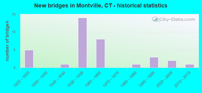
- New bridges - historical statistics
- 51920-1929
- 11940-1949
- 141950-1959
- 81960-1969
- 11980-1989
- 31990-1999
- 22000-2009
- 12010-2019

- Reconstructed bridges - Historical Statistics
- 11980-1989
- 81990-1999
- 12000-2009


- Bridge Condition - Deck
- 4.2%Very good
- 45.8%Good
- 25.0%Satisfactory
- 25.0%Fair

- Bridge Condition - Superstructure
- 8.3%Very good
- 25.0%Good
- 29.2%Satisfactory
- 37.5%Fair

- Bridge Condition - Substructure
- 4.2%Very good
- 33.3%Good
- 54.2%Satisfactory
- 8.3%Fair

- Bridge Condition - Channel
- 11.8%Very good
- 23.5%Good
- 35.3%Satisfactory
- 23.5%Fair
- 5.9%Poor
Find on map >> Show street view
Structure Number: 26, Location: INTERSTATE-95 EXIT NO. 7 (Lat: 41.046603, Lng: -73.545353), Route carried "on" structure: Interstate 95, Year Built: 1958, Year Reconstructed: 1990, Status: Open, Structure Length: 13.27m (43.54ft), Average Daily Traffic: 138,200 (year 2017), Truck Traffic: 9%, Average Future Daily Traffic: 205,351 (year 2037), Design Load: HS 20, Features Intersected: GREENWICH AVE RIPPOWAM
Minimum Vertical Clearance: 30+ m (98+ ft), Kilometerpoint: 11.748, Lanes on structure: 7, Lanes under structure: 3, Base Highway Network: Yes, Owner: State Highway Agency, Approaching Roadway Width: 31.4m (103.0ft), Skew: 31 degrees, Material/Design: Steel, Design/Construction: Stringer/Multi-beam, Number Of Spans In Main Unit: 6, Length of Maximum Span: 22.9m (75.1ft), Curb-To-Curb Width: 31.3m (102.7ft), Out-to-Out Width: 33.5m (109.9ft)
Condition: Deck: Satisfactory, Superstructure: Satisfactory, Substructure: Satisfactory, Channel: Satisfactory, Operating Rating: 62.2 metric tons, Method Used To Determine Operating Rating: Load and Resistance Factor Rating (LRFR) rating reported by rating factor(RF) method using HL-93 loadings, Inventory Rating: 48.0 metric tons, Method Used To Determine Inventory Rating: Load and Resistance Factor Rating (LRFR) rating reported by rating factor(RF) method using HL-93 loadings, Structural Evaluation: Equal to present minimum criteria, Deck Geometry: Equal to present minimum criteria, Underclear: Somewhat better than minimum adequacy, Waterway Adequacy: Superior to present desirable criteria, Approach Roadway Alignment: Equal to present desirable criteria, Designated Inspection Frequency: Every 24 months, Inspection Date: Febuary 2021, Deck Structure Type: Concrete Cast-file-Place, Wearing Surface/Protective System: Wearing Surface: Bituminous, Membrane: Preformed Fabric, Deck Protection: Epoxy Coated Reinforcing
Find on map >> Show street view
Structure Number: 26, Location: 1.0 MI N OF ROUTE 32 (Lat: 41.428286, Lng: -72.123636), Route carried "on" structure: Alternate State highway 693, Year Built: 1958, Status: Open, Structure Length: 1.69m (5.54ft), Average Daily Traffic: 11,750 (year 2017), Truck Traffic: 6%, Average Future Daily Traffic: 17,459 (year 2037), Design Load: HS 20, Features Intersected: INTERSTATE-395 NB
Minimum Vertical Clearance: 30+ m (98+ ft), Kilometerpoint: 2.028, Lanes on structure: 2, Lanes under structure: 2, Owner: State Highway Agency, Approaching Roadway Width: 12.2m (40.0ft), Skew: 3 degrees, Material/Design: Steel, Design/Construction: Stringer/Multi-beam, Number Of Spans In Main Unit: 1, Length of Maximum Span: 15.2m (49.9ft), Curb-To-Curb Width: 12.2m (40.0ft), Out-to-Out Width: 13.3m (43.6ft)
Condition: Deck: Satisfactory, Superstructure: Fair, Substructure: Good, Operating Rating: 59.0 metric tons, Method Used To Determine Operating Rating: Load and Resistance Factor Rating (LRFR) rating reported by rating factor(RF) method using HL-93 loadings, Inventory Rating: 45.4 metric tons, Method Used To Determine Inventory Rating: Load and Resistance Factor Rating (LRFR) rating reported by rating factor(RF) method using HL-93 loadings, Structural Evaluation: Somewhat better than minimum adequacy, Deck Geometry: Better than present minimum criteria, Underclear: High priority of corrective action, Approach Roadway Alignment: Somewhat better than minimum adequacy, Designated Inspection Frequency: Every 24 months, Inspection Date: July 2020, Deck Structure Type: Concrete Cast-file-Place, Wearing Surface/Protective System: Wearing Surface: Bituminous, Membrane: Preformed Fabric
Find on map >> Show street view
Structure Number: 261, Location: 0.6 MI S OF ROUTE 163 (Lat: 41.433658, Lng: -72.120628), Route carried "on" structure: City street , Year Built: 1958, Status: Open, Structure Length: 4.88m (16.01ft), Average Daily Traffic: 610 (year 2021), Truck Traffic: 4%, Average Future Daily Traffic: 906 (year 2041), Design Load: HS 20, Features Intersected: INTERSTATE-395, Facility Carried by Structure: MOXLEY ROAD
Minimum Vertical Clearance: 30+ m (98+ ft), Kilometerpoint: 2.816, Lanes on structure: 2, Lanes under structure: 4, Owner: State Highway Agency, Approaching Roadway Width: 12.2m (40.0ft), Skew: 1 degrees, Material/Design: Steel, Design/Construction: Stringer/Multi-beam, Number Of Spans In Main Unit: 2, Length of Maximum Span: 25.0m (82.0ft), Curb or Sidewalk Widths: Left: 0.5m (1.6ft), Right: 0.5m (1.6ft), Curb-To-Curb Width: 12.2m (40.0ft), Out-to-Out Width: 13.9m (45.6ft)
Condition: Deck: Fair, Superstructure: Fair, Substructure: Good, Operating Rating: 43.4 metric tons, Method Used To Determine Operating Rating: Load and Resistance Factor Rating (LRFR) rating reported by rating factor(RF) method using HL-93 loadings, Inventory Rating: 33.4 metric tons, Method Used To Determine Inventory Rating: Load and Resistance Factor Rating (LRFR) rating reported by rating factor(RF) method using HL-93 loadings, Structural Evaluation: Somewhat better than minimum adequacy, Deck Geometry: Equal to present desirable criteria, Underclear: High priority of corrective action, Approach Roadway Alignment: Somewhat better than minimum adequacy, Designated Inspection Frequency: Every 24 months, Inspection Date: March 2021, Deck Structure Type: Concrete Cast-file-Place, Wearing Surface/Protective System: Wearing Surface: Bituminous, Membrane: Preformed Fabric
Find on map >> Show street view
Structure Number: 262, Location: 0.3 MI S OF ROUTE 163 (Lat: 41.437947, Lng: -72.118603), Route carried "on" structure: Interstate 395, Year Built: 1958, Year Reconstructed: 1996, Status: Open, Structure Length: 1.81m (5.94ft), Average Daily Traffic: 49,500 (year 2020), Truck Traffic: 9%, Average Future Daily Traffic: 73,552 (year 2040), Design Load: HS 20, Features Intersected: MAPLE AVENUE
Minimum Vertical Clearance: 30+ m (98+ ft), Kilometerpoint: 9.737, Lanes on structure: 4, Lanes under structure: 2, Base Highway Network: Yes, Owner: State Highway Agency, Approaching Roadway Width: 28.7m (94.2ft), Skew: 32 degrees, Material/Design: Steel, Design/Construction: Stringer/Multi-beam, Number Of Spans In Main Unit: 1, Length of Maximum Span: 16.6m (54.5ft), Curb-To-Curb Width: 28.6m (93.8ft), Out-to-Out Width: 31.6m (103.7ft)
Condition: Deck: Satisfactory, Superstructure: Good, Substructure: Good, Operating Rating: 56.7 metric tons, Method Used To Determine Operating Rating: Load and Resistance Factor Rating (LRFR) rating reported by rating factor(RF) method using HL-93 loadings, Inventory Rating: 43.4 metric tons, Method Used To Determine Inventory Rating: Load and Resistance Factor Rating (LRFR) rating reported by rating factor(RF) method using HL-93 loadings, Structural Evaluation: Better than present minimum criteria, Deck Geometry: Superior to present desirable criteria, Underclear: High priority of corrective action, Approach Roadway Alignment: Equal to present desirable criteria, Designated Inspection Frequency: Every 24 months, Inspection Date: January 2022, Deck Structure Type: Concrete Cast-file-Place, Wearing Surface/Protective System: Wearing Surface: Bituminous, Membrane: Preformed Fabric, Deck Protection: Epoxy Coated Reinforcing
Find on map >> Show street view
Structure Number: 263, Location: 325 FT S OF ROUTE 163 (Lat: 41.440739, Lng: -72.117483), Route carried "on" structure: Interstate 395, Year Built: 1958, Year Reconstructed: 1996, Status: Open, Structure Length: 5.87m (19.26ft), Average Daily Traffic: 56,500 (year 2017), Truck Traffic: 14%, Average Future Daily Traffic: 83,953 (year 2037), Design Load: HS 20, Features Intersected: OXOBOXO BRK & NEC ABAND.
Minimum Vertical Clearance: 30+ m (98+ ft), Kilometerpoint: 10.042, Lanes on structure: 4, Base Highway Network: Yes, Owner: State Highway Agency, Approaching Roadway Width: 28.7m (94.2ft), Skew: 31 degrees, Material/Design: Steel, Design/Construction: Stringer/Multi-beam, Number Of Spans In Main Unit: 2, Length of Maximum Span: 33.8m (110.9ft), Curb-To-Curb Width: 28.6m (93.8ft), Out-to-Out Width: 31.6m (103.7ft)
Condition: Deck: Good, Superstructure: Satisfactory, Substructure: Satisfactory, Channel: Good, Operating Rating: 38.6 metric tons, Method Used To Determine Operating Rating: Load and Resistance Factor Rating (LRFR) rating reported by rating factor(RF) method using HL-93 loadings, Inventory Rating: 29.8 metric tons, Method Used To Determine Inventory Rating: Load and Resistance Factor Rating (LRFR) rating reported by rating factor(RF) method using HL-93 loadings, Structural Evaluation: Equal to present minimum criteria, Deck Geometry: Superior to present desirable criteria, Waterway Adequacy: Better than present minimum criteria, Approach Roadway Alignment: Equal to present desirable criteria, Designated Inspection Frequency: Every 24 months, Inspection Date: October 2020, Deck Structure Type: Concrete Cast-file-Place, Wearing Surface/Protective System: Wearing Surface: Bituminous, Membrane: Preformed Fabric, Deck Protection: Epoxy Coated Reinforcing
Find on map >> Show street view
Structure Number: 264, Location: I-395 EXIT NO. 79 (Lat: 41.441544, Lng: -72.117375), Route carried "on" structure: Interstate 395, Year Built: 1958, Year Reconstructed: 1996, Status: Open, Structure Length: 5.06m (16.60ft), Average Daily Traffic: 56,500 (year 2017), Truck Traffic: 14%, Average Future Daily Traffic: 83,953 (year 2037), Design Load: HS 20, Features Intersected: ROUTE 163
Minimum Vertical Clearance: 30+ m (98+ ft), Kilometerpoint: 10.139, Lanes on structure: 4, Lanes under structure: 2, Base Highway Network: Yes, Owner: State Highway Agency, Approaching Roadway Width: 28.7m (94.2ft), Skew: 34 degrees, Material/Design: Steel, Design/Construction: Stringer/Multi-beam, Number Of Spans In Main Unit: 3, Length of Maximum Span: 21.4m (70.2ft), Curb-To-Curb Width: 28.6m (93.8ft), Out-to-Out Width: 33.1m (108.6ft)
Condition: Deck: Good, Superstructure: Satisfactory, Substructure: Satisfactory, Operating Rating: 28.5 metric tons, Method Used To Determine Operating Rating: Load and Resistance Factor Rating (LRFR) rating reported by rating factor(RF) method using HL-93 loadings, Inventory Rating: 22.0 metric tons, Method Used To Determine Inventory Rating: Load and Resistance Factor Rating (LRFR) rating reported by rating factor(RF) method using HL-93 loadings, Structural Evaluation: Somewhat better than minimum adequacy, Deck Geometry: Superior to present desirable criteria, Underclear: Somewhat better than minimum adequacy, Approach Roadway Alignment: Equal to present desirable criteria, Designated Inspection Frequency: Every 24 months, Inspection Date: June 2020, Deck Structure Type: Concrete Cast-file-Place, Wearing Surface/Protective System: Wearing Surface: Bituminous, Membrane: Preformed Fabric, Deck Protection: Epoxy Coated Reinforcing
Find on map >> Show street view
Structure Number: 265, Location: 1.3 MI NORTH OF ROUTE 163 (Lat: 41.460658, Lng: -72.115147), Route carried "on" structure: Interstate 395, Year Built: 1958, Year Reconstructed: 1996, Status: Open, Structure Length: 3.95m (12.96ft), Average Daily Traffic: 57,100 (year 2017), Truck Traffic: 15%, Average Future Daily Traffic: 84,845 (year 2037), Design Load: HS 20, Features Intersected: RAYMOND HILL RD & BROOK
Minimum Vertical Clearance: 30+ m (98+ ft), Kilometerpoint: 12.295, Lanes on structure: 4, Lanes under structure: 2, Base Highway Network: Yes, Owner: State Highway Agency, Approaching Roadway Width: 28.6m (93.8ft), Skew: 30 degrees, Material/Design: Steel, Design/Construction: Stringer/Multi-beam, Number Of Spans In Main Unit: 2, Length of Maximum Span: 18.9m (62.0ft), Curb-To-Curb Width: 28.6m (93.8ft), Out-to-Out Width: 31.6m (103.7ft)
Condition: Deck: Good, Superstructure: Satisfactory, Substructure: Satisfactory, Channel: Good, Operating Rating: 38.6 metric tons, Method Used To Determine Operating Rating: Load and Resistance Factor Rating (LRFR) rating reported by rating factor(RF) method using HL-93 loadings, Inventory Rating: 29.5 metric tons, Method Used To Determine Inventory Rating: Load and Resistance Factor Rating (LRFR) rating reported by rating factor(RF) method using HL-93 loadings, Structural Evaluation: Equal to present minimum criteria, Deck Geometry: Superior to present desirable criteria, Underclear: Somewhat better than minimum adequacy, Waterway Adequacy: Better than present minimum criteria, Approach Roadway Alignment: Equal to present desirable criteria, Designated Inspection Frequency: Every 24 months, Inspection Date: July 2020, Deck Structure Type: Concrete Cast-file-Place, Wearing Surface/Protective System: Wearing Surface: Bituminous, Membrane: Preformed Fabric, Deck Protection: Epoxy Coated Reinforcing
Find on map >> Show street view
Structure Number: 266, Location: 0.2 MI S OF ROUTE 2A (Lat: 41.484272, Lng: -72.115878), Route carried "on" structure: City street , Year Built: 1958, Status: Open, Structure Length: 5.56m (18.24ft), Average Daily Traffic: 480 (year 2020), Truck Traffic: 7%, Average Future Daily Traffic: 713 (year 2040), Design Load: HS 20, Features Intersected: INTERSTATE-395, Facility Carried by Structure: GALLIVAN LANE
Minimum Vertical Clearance: 30+ m (98+ ft), Kilometerpoint: 0.708, Lanes on structure: 2, Lanes under structure: 5, Owner: State Highway Agency, Approaching Roadway Width: 12.2m (40.0ft), Skew: 2 degrees, Material/Design: Steel, Design/Construction: Stringer/Multi-beam, Number Of Spans In Main Unit: 2, Length of Maximum Span: 29.5m (96.8ft), Curb or Sidewalk Widths: Left: 0.5m (1.6ft), Right: 0.5m (1.6ft), Curb-To-Curb Width: 12.2m (40.0ft), Out-to-Out Width: 13.9m (45.6ft)
Condition: Deck: Satisfactory, Superstructure: Fair, Substructure: Satisfactory, Operating Rating: 19.8 metric tons, Method Used To Determine Operating Rating: Load and Resistance Factor Rating (LRFR) rating reported by rating factor(RF) method using HL-93 loadings, Inventory Rating: 15.2 metric tons, Method Used To Determine Inventory Rating: Load and Resistance Factor Rating (LRFR) rating reported by rating factor(RF) method using HL-93 loadings, Structural Evaluation: Meets minimum limits, Deck Geometry: Equal to present desirable criteria, Underclear: High priority of corrective action, Approach Roadway Alignment: Somewhat better than minimum adequacy, Designated Inspection Frequency: Every 24 months, Inspection Date: Febuary 2020, Deck Structure Type: Concrete Cast-file-Place, Wearing Surface/Protective System: Wearing Surface: Bituminous, Membrane: Preformed Fabric
Find on map >> Show street view
Structure Number: 267, Location: 1.2 MI S OF ROUTE 82 (Lat: 41.493150, Lng: -72.114744), Route carried "on" structure: City street , Year Built: 1958, Status: Open, Structure Length: 5.55m (18.21ft), Average Daily Traffic: 1,080 (year 2020), Truck Traffic: 7%, Average Future Daily Traffic: 1,605 (year 2040), Design Load: HS 20, Features Intersected: INTERSTATE-395, Facility Carried by Structure: FITCH HILL ROAD
Minimum Vertical Clearance: 30+ m (98+ ft), Kilometerpoint: 2.720, Lanes on structure: 2, Lanes under structure: 6, Owner: State Highway Agency, Approaching Roadway Width: 12.2m (40.0ft), Skew: 3 degrees, Material/Design: Steel, Design/Construction: Stringer/Multi-beam, Number Of Spans In Main Unit: 2, Length of Maximum Span: 26.8m (87.9ft), Curb or Sidewalk Widths: Left: 0.5m (1.6ft), Right: 0.5m (1.6ft), Curb-To-Curb Width: 12.2m (40.0ft), Out-to-Out Width: 13.9m (45.6ft)
Condition: Deck: Satisfactory, Superstructure: Satisfactory, Substructure: Satisfactory, Operating Rating: 50.2 metric tons, Method Used To Determine Operating Rating: Load and Resistance Factor Rating (LRFR) rating reported by rating factor(RF) method using HL-93 loadings, Inventory Rating: 38.9 metric tons, Method Used To Determine Inventory Rating: Load and Resistance Factor Rating (LRFR) rating reported by rating factor(RF) method using HL-93 loadings, Structural Evaluation: Equal to present minimum criteria, Deck Geometry: Better than present minimum criteria, Underclear: Meets minimum limits, Approach Roadway Alignment: Somewhat better than minimum adequacy, Designated Inspection Frequency: Every 24 months, Inspection Date: Febuary 2020, Deck Structure Type: Concrete Cast-file-Place, Wearing Surface/Protective System: Wearing Surface: Bituminous, Membrane: Preformed Fabric
Find on map >> Show street view
Structure Number: 532, Location: 0.6 MI N OF ROUTE 33 JCT (Lat: 41.204722, Lng: -73.430333), Route carried "on" structure: US 7, Year Built: 2008, Status: Open, Structure Length: 1.83m (6.00ft), Average Daily Traffic: 31,600 (year 2017), Truck Traffic: 6%, Average Future Daily Traffic: 46,954 (year 2037), Design Load: HS 20, Features Intersected: NORWALK RIVER
Minimum Vertical Clearance: 30+ m (98+ ft), Kilometerpoint: 12.746, Lanes on structure: 4, Base Highway Network: Yes, Owner: State Highway Agency, Approaching Roadway Width: 23.8m (78.1ft), Skew: 1 degrees, Material/Design: Prestressed concrete, Design/Construction: Stringer/Multi-beam, Number Of Spans In Main Unit: 1, Length of Maximum Span: 16.5m (54.1ft), Curb or Sidewalk Widths: Left: 3.7m (12.1ft), Right: 0.0m, Curb-To-Curb Width: 19.2m (63.0ft), Out-to-Out Width: 23.8m (78.1ft)
Condition: Deck: Good, Superstructure: Good, Substructure: Good, Channel: Satisfactory, Operating Rating: 42.8 metric tons, Method Used To Determine Operating Rating: Load and Resistance Factor Rating (LRFR) rating reported by rating factor(RF) method using HL-93 loadings, Inventory Rating: 33.0 metric tons, Method Used To Determine Inventory Rating: Load and Resistance Factor Rating (LRFR) rating reported by rating factor(RF) method using HL-93 loadings, Structural Evaluation: Better than present minimum criteria, Deck Geometry: Equal to present minimum criteria, Waterway Adequacy: Superior to present desirable criteria, Approach Roadway Alignment: Equal to present desirable criteria, Designated Inspection Frequency: Every 24 months, Inspection Date: August 2020, Deck Structure Type: Concrete Cast-file-Place, Wearing Surface/Protective System: Wearing Surface: Bituminous, Membrane: Built-up, Deck Protection: Epoxy Coated Reinforcing
Find on map >> Show street view
Structure Number: 1248, Location: 0.9 MI N OF ROUTE 161 (Lat: 41.437333, Lng: -72.225756), Route carried "on" structure: State highway 85, Year Built: 1922, Status: Open, Structure Length: 0.70m (2.30ft), Average Daily Traffic: 13,800 (year 2017), Truck Traffic: 7%, Average Future Daily Traffic: 20,505 (year 2037), Design Load: H 15, Features Intersected: LATIMERS BROOK
Minimum Vertical Clearance: 30+ m (98+ ft), Kilometerpoint: 12.617, Lanes on structure: 2, Base Highway Network: Yes, Owner: State Highway Agency, Approaching Roadway Width: 7.9m (25.9ft), Material/Design: Concrete, Design/Construction: Slab, Number Of Spans In Main Unit: 1, Length of Maximum Span: 6.1m (20.0ft), Curb-To-Curb Width: 8.6m (28.2ft), Out-to-Out Width: 9.4m (30.8ft)
Condition: Deck: Fair, Superstructure: Fair, Substructure: Satisfactory, Channel: Fair, Operating Rating: 65.0 metric tons, Method Used To Determine Operating Rating: Load Factor (LF), Inventory Rating: 39.0 metric tons, Method Used To Determine Inventory Rating: Load Factor (LF), Structural Evaluation: Somewhat better than minimum adequacy, Deck Geometry: High priority of replacement, Waterway Adequacy: High priority of corrective action, Approach Roadway Alignment: Equal to present desirable criteria, Designated Inspection Frequency: Every 24 months, Inspection Date: November 2020, Deck Structure Type: Concrete Cast-file-Place, Wearing Surface/Protective System: Wearing Surface: Bituminous
Find on map >> Show street view
Structure Number: 1404, Location: 0.2 MI N OF ROUTE 32 (Lat: 41.437775, Lng: -72.112472), Route carried "on" structure: State highway 163, Year Built: 2001, Status: Open, Structure Length: 1.13m (3.71ft), Average Daily Traffic: 7,200 (year 2018), Truck Traffic: 3%, Average Future Daily Traffic: 10,698 (year 2038), Design Load: HS 20, Features Intersected: OXOBOXO BROOK
Minimum Vertical Clearance: 30+ m (98+ ft), Kilometerpoint: 0.274, Lanes on structure: 2, Owner: State Highway Agency, Approaching Roadway Width: 7.9m (25.9ft), Skew: 2 degrees, Material/Design: Concrete, Design/Construction: Culvert, Number Of Spans In Main Unit: 3, Length of Maximum Span: 3.4m (11.2ft), Curb-To-Curb Width: 9.8m (32.2ft), Out-to-Out Width: 10.9m (35.8ft)
Condition: Channel: Poor, Culverts: Satisfactory, Operating Rating: 42.6 metric tons, Method Used To Determine Operating Rating: Field evaluation and documented engineering judgment, Inventory Rating: 32.7 metric tons, Method Used To Determine Inventory Rating: Field evaluation and documented engineering judgment, Structural Evaluation: Equal to present minimum criteria, Deck Geometry: Meets minimum limits, Waterway Adequacy: Equal to present desirable criteria, Approach Roadway Alignment: Equal to present desirable criteria, Designated Inspection Frequency: Every 24 months, Inspection Date: March 2020, Deck Structure Type: Other, Wearing Surface/Protective System: Wearing Surface: Bituminous, Membrane: Built-up, Deck Protection: Epoxy Coated Reinforcing
Find on map >> Show street view
Structure Number: 1406, Location: 3.3 MI S OF ROUTE 82 (Lat: 41.473289, Lng: -72.164244), Route carried "on" structure: State highway 163, Year Built: 1925, Status: Open, Structure Length: 0.76m (2.49ft), Average Daily Traffic: 1,400 (year 2017), Truck Traffic: 3%, Average Future Daily Traffic: 2,080 (year 2037), Design Load: HS 15, Features Intersected: OXOBOXO BROOK
Minimum Vertical Clearance: 30+ m (98+ ft), Kilometerpoint: 6.534, Lanes on structure: 2, Owner: State Highway Agency, Approaching Roadway Width: 8.5m (27.9ft), Skew: 2 degrees, Material/Design: Concrete, Design/Construction: Slab, Number Of Spans In Main Unit: 1, Length of Maximum Span: 6.7m (22.0ft), Curb-To-Curb Width: 9.1m (29.9ft), Out-to-Out Width: 10.0m (32.8ft)
Condition: Deck: Fair, Superstructure: Fair, Substructure: Fair, Channel: Fair, Operating Rating: 42.6 metric tons, Method Used To Determine Operating Rating: Field evaluation and documented engineering judgment, Inventory Rating: 32.7 metric tons, Method Used To Determine Inventory Rating: Field evaluation and documented engineering judgment, Structural Evaluation: Somewhat better than minimum adequacy, Deck Geometry: Somewhat better than minimum adequacy, Waterway Adequacy: Better than present minimum criteria, Approach Roadway Alignment: Equal to present desirable criteria, Designated Inspection Frequency: Every 24 months, Inspection Date: March 2020, Deck Structure Type: Concrete Cast-file-Place, Wearing Surface/Protective System: Wearing Surface: Bituminous
Find on map >> Show street view
Structure Number: 2729, Location: 3.3 MI N OF I-395 (Lat: 41.465947, Lng: -72.158447), Route carried "on" structure: State highway 163, Year Built: 2014, Status: Open, Structure Length: 0.61m (2.00ft), Average Daily Traffic: 2,600 (year 2015), Truck Traffic: 3%, Average Future Daily Traffic: 3,863 (year 2035), Design Load: HL 93, Features Intersected: OAKDALE BROOK
Minimum Vertical Clearance: 30+ m (98+ ft), Kilometerpoint: 5.456, Lanes on structure: 2, Owner: State Highway Agency, Approaching Roadway Width: 8.5m (27.9ft), Material/Design: Concrete, Design/Construction: Frame, Number Of Spans In Main Unit: 1, Length of Maximum Span: 6.1m (20.0ft), Curb or Sidewalk Widths: Left: 0.0m, Right: 1.5m (4.9ft), Curb-To-Curb Width: 8.5m (27.9ft), Out-to-Out Width: 11.0m (36.1ft)
Condition: Deck: Good, Superstructure: Very good, Substructure: Very good, Channel: Very good, Operating Rating: 64.2 metric tons, Method Used To Determine Operating Rating: Load and Resistance Factor Rating (LRFR) rating reported by rating factor(RF) method using HL-93 loadings, Inventory Rating: 49.6 metric tons, Method Used To Determine Inventory Rating: Load and Resistance Factor Rating (LRFR) rating reported by rating factor(RF) method using HL-93 loadings, Structural Evaluation: Equal to present desirable criteria, Deck Geometry: Meets minimum limits, Waterway Adequacy: Equal to present desirable criteria, Approach Roadway Alignment: Better than present minimum criteria, Designated Inspection Frequency: Every 48 months, Inspection Date: January 2019, Wearing Surface/Protective System: Wearing Surface: Bituminous, Membrane: Other, Deck Protection: Epoxy Coated Reinforcing
Find on map >> Show street view
Structure Number: 3422, Location: 0.9 MI W OF ROUTE 32 (Lat: 41.487306, Lng: -72.115097), Route carried "on" structure: Alternate State highway 2A, Year Built: 1967, Status: Open, Structure Length: 5.24m (17.19ft), Average Daily Traffic: 17,600 (year 2017), Truck Traffic: 5%, Average Future Daily Traffic: 26,152 (year 2037), Design Load: HS 20, Features Intersected: INTERSTATE-395
Minimum Vertical Clearance: 30+ m (98+ ft), Kilometerpoint: 7.033, Lanes on structure: 2, Lanes under structure: 5, Owner: State Highway Agency, Approaching Roadway Width: 16.5m (54.1ft), Skew: 20 degrees, Material/Design: Prestressed concrete continuous, Design/Construction: Stringer/Multi-beam, Number Of Spans In Main Unit: 2, Length of Maximum Span: 28.0m (91.9ft), Curb-To-Curb Width: 16.4m (53.8ft), Out-to-Out Width: 20.6m (67.6ft)
Condition: Deck: Good, Superstructure: Fair, Substructure: Satisfactory, Operating Rating: 76.8 metric tons, Method Used To Determine Operating Rating: Load Factor (LF), Inventory Rating: 46.1 metric tons, Method Used To Determine Inventory Rating: Load Factor (LF), Structural Evaluation: Somewhat better than minimum adequacy, Deck Geometry: Superior to present desirable criteria, Underclear: High priority of corrective action, Approach Roadway Alignment: Somewhat better than minimum adequacy, Designated Inspection Frequency: Every 24 months, Inspection Date: Febuary 2020, Deck Structure Type: Concrete Cast-file-Place, Wearing Surface/Protective System: Wearing Surface: Bituminous, Membrane: Built-up
Find on map >> Show street view
Structure Number: 3425, Location: 1.5 MI E OF I-395 (Lat: 41.480833, Lng: -72.086892), Route carried "on" structure: Alternate State highway 2A, Year Built: 1967, Year Reconstructed: 2008, Status: Open, Structure Length: 4.18m (13.71ft), Average Daily Traffic: 31,000 (year 2017), Truck Traffic: 8%, Average Future Daily Traffic: 46,063 (year 2037), Design Load: HS 20, Features Intersected: MASSAPEAG SIDE RD
Minimum Vertical Clearance: 30+ m (98+ ft), Kilometerpoint: 9.576, Lanes on structure: 6, Lanes under structure: 2, Owner: State Highway Agency, Approaching Roadway Width: 31.7m (104.0ft), Skew: 33 degrees, Material/Design: Prestressed concrete continuous, Design/Construction: Stringer/Multi-beam, Number Of Spans In Main Unit: 3, Length of Maximum Span: 19.5m (64.0ft), Curb-To-Curb Width: 31.7m (104.0ft), Out-to-Out Width: 34.6m (113.5ft)
Condition: Deck: Good, Superstructure: Satisfactory, Substructure: Fair, Operating Rating: 43.1 metric tons, Method Used To Determine Operating Rating: Load and Resistance Factor Rating (LRFR) rating reported by rating factor(RF) method using HL-93 loadings, Inventory Rating: 32.1 metric tons, Method Used To Determine Inventory Rating: Load and Resistance Factor Rating (LRFR) rating reported by rating factor(RF) method using HL-93 loadings, Structural Evaluation: Somewhat better than minimum adequacy, Deck Geometry: Superior to present desirable criteria, Underclear: Equal to present minimum criteria, Approach Roadway Alignment: Equal to present desirable criteria, Designated Inspection Frequency: Every 24 months, Inspection Date: January 2020, Deck Structure Type: Concrete Cast-file-Place, Wearing Surface/Protective System: Wearing Surface: Bituminous, Membrane: Built-up
Find on map >> Show street view
Structure Number: 3426, Location: 1.0 MILE EAST OF JCT 32 (Lat: 41.481850, Lng: -72.073875), Route carried "on" structure: Alternate State highway 2A, Year Built: 1967, Year Reconstructed: 1996, Status: Open, Structure Length: 43.72m (143.44ft), Average Daily Traffic: 23,000 (year 2017), Truck Traffic: 8%, Average Future Daily Traffic: 34,176 (year 2037), Design Load: HS 20, Features Intersected: NECRR, P&WRR & THAMES RV
Minimum Vertical Clearance: 30+ m (98+ ft), Kilometerpoint: 10.461, Lanes on structure: 2, Owner: State Highway Agency, Approaching Roadway Width: 12.2m (40.0ft), Navigation Control: Yes ( Vertical Clearance: 22.9m (75.1ft), Horizontal Clearance: 61.0m (200.1ft)), Material/Design: Steel continuous, Design/Construction: Stringer/Multi-beam, Number Of Spans In Main Unit: 5, Number Of Approach Spans: 2, Length of Maximum Span: 83.8m (274.9ft), Curb or Sidewalk Widths: Left: 0.2m (0.7ft), Right: 0.2m (0.7ft), Curb-To-Curb Width: 12.2m (40.0ft), Out-to-Out Width: 13.3m (43.6ft)
Condition: Deck: Fair, Superstructure: Fair, Substructure: Satisfactory, Channel: Fair, Operating Rating: 33.7 metric tons, Method Used To Determine Operating Rating: Load and Resistance Factor Rating (LRFR) rating reported by rating factor(RF) method using HL-93 loadings, Inventory Rating: 25.9 metric tons, Method Used To Determine Inventory Rating: Load and Resistance Factor Rating (LRFR) rating reported by rating factor(RF) method using HL-93 loadings, Structural Evaluation: Somewhat better than minimum adequacy, Deck Geometry: Somewhat better than minimum adequacy, Underclear: Somewhat better than minimum adequacy, Waterway Adequacy: Equal to present desirable criteria, Approach Roadway Alignment: Equal to present desirable criteria, Designated Inspection Frequency: Every 24 months, Underwater Inspection Frequency: Every 24 months, Other Special Inspection Frequency: Every 24 months, Inspection Date: August 2020, Underwater Inspection Date: August 2020, Other Special Inspection Date: August 2020, Deck Structure Type: Concrete Cast-file-Place, Wearing Surface/Protective System: Wearing Surface: Bituminous, Membrane: Built-up
Find on map >> Show street view
Structure Number: 3966, Location: 0.3 MI S OF ROUTE 32 (Lat: 41.436633, Lng: -72.106122), Route carried "on" structure: City street , Year Built: 1960, Status: Open, Structure Length: 0.85m (2.79ft), Average Daily Traffic: 1,500 (year 2015), Truck Traffic: 4%, Average Future Daily Traffic: 2,229 (year 2035), Features Intersected: OXOBOXO BROOK, Facility Carried by Structure: PINK ROW ROAD
Minimum Vertical Clearance: 30+ m (98+ ft), Kilometerpoint: 0.322, Lanes on structure: 2, Owner: Town or Township Highway Agency, Approaching Roadway Width: 6.1m (20.0ft), Skew: 1 degrees, Material/Design: Concrete, Design/Construction: Slab, Number Of Spans In Main Unit: 1, Length of Maximum Span: 7.9m (25.9ft), Curb or Sidewalk Widths: Left: 0.2m (0.7ft), Right: 0.2m (0.7ft), Curb-To-Curb Width: 6.2m (20.3ft), Out-to-Out Width: 7.2m (23.6ft)
Condition: Deck: Fair, Superstructure: Fair, Substructure: Good, Channel: Good, Operating Rating: 42.6 metric tons, Method Used To Determine Operating Rating: Field evaluation and documented engineering judgment, Inventory Rating: 32.7 metric tons, Method Used To Determine Inventory Rating: Field evaluation and documented engineering judgment, Structural Evaluation: Somewhat better than minimum adequacy, Deck Geometry: High priority of replacement, Waterway Adequacy: Better than present minimum criteria, Approach Roadway Alignment: Equal to present minimum criteria, Designated Inspection Frequency: Every 24 months, Inspection Date: April 2021, Deck Structure Type: Concrete Cast-file-Place, Wearing Surface/Protective System: Wearing Surface: Bituminous
Find on map >> Show street view
Structure Number: 3967, Location: 0.2 MI N OF ROUTE 32 (Lat: 41.498039, Lng: -72.102128), Route carried "on" structure: City street , Year Built: 1965, Status: Open, Structure Length: 1.43m (4.69ft), Average Daily Traffic: 9,400 (year 2017), Truck Traffic: 4%, Average Future Daily Traffic: 13,967 (year 2037), Design Load: HS 20, Features Intersected: TRADING COVE BROOK, Facility Carried by Structure: NEW LONDON TPKE
Minimum Vertical Clearance: 30+ m (98+ ft), Kilometerpoint: 0.241, Lanes on structure: 2, Owner: Town or Township Highway Agency, Approaching Roadway Width: 9.1m (29.9ft), Skew: 2 degrees, Material/Design: Prestressed concrete, Design/Construction: Slab, Number Of Spans In Main Unit: 1, Length of Maximum Span: 13.7m (44.9ft), Curb or Sidewalk Widths: Left: 1.7m (5.6ft), Right: 0.5m (1.6ft), Curb-To-Curb Width: 9.1m (29.9ft), Out-to-Out Width: 12.0m (39.4ft)
Condition: Deck: Satisfactory, Superstructure: Satisfactory, Substructure: Good, Channel: Good, Operating Rating: 47.6 metric tons, Method Used To Determine Operating Rating: Load and Resistance Factor Rating (LRFR) rating reported by rating factor(RF) method using HL-93 loadings, Inventory Rating: 36.6 metric tons, Method Used To Determine Inventory Rating: Load and Resistance Factor Rating (LRFR) rating reported by rating factor(RF) method using HL-93 loadings, Structural Evaluation: Equal to present minimum criteria, Deck Geometry: High priority of corrective action, Waterway Adequacy: Equal to present desirable criteria, Approach Roadway Alignment: Equal to present desirable criteria, Designated Inspection Frequency: Every 24 months, Inspection Date: April 2021, Deck Structure Type: Other, Wearing Surface/Protective System: Wearing Surface: Bituminous, Membrane: Built-up
Find on map >> Show street view
Structure Number: 474, Location: 75 FT W OF ROUTE 163 (Lat: 41.448858, Lng: -72.130189), Route carried "on" structure: City street , Year Built: 1920, Year Reconstructed: 1990, Status: Open, Structure Length: 0.88m (2.89ft), Average Daily Traffic: 1,035 (year 2021), Truck Traffic: 7%, Average Future Daily Traffic: 1,538 (year 2041), Design Load: HS 20, Features Intersected: OXOBOXO BROOK, Facility Carried by Structure: BRIDGE STREET
Minimum Vertical Clearance: 30+ m (98+ ft), Kilometerpoint: 0.161, Lanes on structure: 2, Owner: Town or Township Highway Agency, Approaching Roadway Width: 8.2m (26.9ft), Material/Design: Prestressed concrete, Design/Construction: Box Beam or Girders - Multiple, Number Of Spans In Main Unit: 1, Length of Maximum Span: 7.9m (25.9ft), Curb-To-Curb Width: 8.1m (26.6ft), Out-to-Out Width: 8.8m (28.9ft)
Condition: Deck: Good, Superstructure: Good, Substructure: Satisfactory, Channel: Satisfactory, Operating Rating: 79.5 metric tons, Method Used To Determine Operating Rating: Load Factor (LF), Inventory Rating: 47.6 metric tons, Method Used To Determine Inventory Rating: Load Factor (LF), Structural Evaluation: Equal to present minimum criteria, Deck Geometry: Meets minimum limits, Waterway Adequacy: Equal to present desirable criteria, Approach Roadway Alignment: Equal to present desirable criteria, Designated Inspection Frequency: Every 24 months, Underwater Inspection Frequency: Every 24 months, Inspection Date: March 2021, Underwater Inspection Date: March 2021, Deck Structure Type: Other, Wearing Surface/Protective System: Wearing Surface: Bituminous, Membrane: Built-up
Find on map >> Show street view
Structure Number: 4742, Location: 0.2 MI S OF ROUTE 85 (Lat: 41.427542, Lng: -72.221039), Route carried "on" structure: City street , Year Built: 1940, Status: Open, Structure Length: 0.73m (2.40ft), Average Daily Traffic: 340 (year 2021), Truck Traffic: 7%, Average Future Daily Traffic: 505 (year 2041), Design Load: H 20, Features Intersected: LATIMER BROOK, Facility Carried by Structure: GRASSY HILL ROAD
Minimum Vertical Clearance: 30+ m (98+ ft), Kilometerpoint: 0.708, Lanes on structure: 2, Owner: Town or Township Highway Agency, Approaching Roadway Width: 5.8m (19.0ft), Skew: 2 degrees, Material/Design: Concrete, Design/Construction: Slab, Number Of Spans In Main Unit: 1, Length of Maximum Span: 6.4m (21.0ft), Curb or Sidewalk Widths: Left: 0.2m (0.7ft), Right: 0.2m (0.7ft), Curb-To-Curb Width: 6.1m (20.0ft), Out-to-Out Width: 7.6m (24.9ft)
Condition: Deck: Fair, Superstructure: Fair, Substructure: Good, Channel: Satisfactory, Operating Rating: 52.6 metric tons, Method Used To Determine Operating Rating: Field evaluation and documented engineering judgment, Inventory Rating: 30.8 metric tons, Method Used To Determine Inventory Rating: Field evaluation and documented engineering judgment, Structural Evaluation: Somewhat better than minimum adequacy, Deck Geometry: Meets minimum limits, Waterway Adequacy: Equal to present desirable criteria, Approach Roadway Alignment: Equal to present desirable criteria, Designated Inspection Frequency: Every 24 months, Inspection Date: April 2021, Deck Structure Type: Concrete Cast-file-Place, Wearing Surface/Protective System: Wearing Surface: Bituminous
Find on map >> Show street view
Structure Number: 532, Location: 1.0 MI S OF ROUTE 85 (Lat: 41.414317, Lng: -72.218697), Route carried "on" structure: State highway 161, Year Built: 1984, Status: Open, Structure Length: 1.19m (3.90ft), Average Daily Traffic: 4,500 (year 2017), Truck Traffic: 3%, Average Future Daily Traffic: 6,687 (year 2037), Design Load: HS 20, Features Intersected: LATIMERS BROOK
Minimum Vertical Clearance: 30+ m (98+ ft), Kilometerpoint: 11.314, Lanes on structure: 2, Owner: State Highway Agency, Approaching Roadway Width: 9.1m (29.9ft), Material/Design: Concrete, Design/Construction: Culvert, Number Of Spans In Main Unit: 3, Length of Maximum Span: 3.7m (12.1ft), Curb-To-Curb Width: 9.1m (29.9ft), Out-to-Out Width: 10.3m (33.8ft)
Condition: Channel: Satisfactory, Culverts: Satisfactory, Operating Rating: 42.6 metric tons, Method Used To Determine Operating Rating: Field evaluation and documented engineering judgment, Inventory Rating: 32.7 metric tons, Method Used To Determine Inventory Rating: Field evaluation and documented engineering judgment, Structural Evaluation: Equal to present minimum criteria, Deck Geometry: Meets minimum limits, Waterway Adequacy: Better than present minimum criteria, Approach Roadway Alignment: Equal to present minimum criteria, Designated Inspection Frequency: Every 24 months, Inspection Date: April 2021, Deck Structure Type: Other, Wearing Surface/Protective System: Wearing Surface: Bituminous
Find on map >> Show street view
Structure Number: 5545, Location: 1.2 MI NORTH OF ROUTE 163 (Lat: 41.452300, Lng: -72.107281), Route carried "on" structure: State highway 32, Year Built: 1927, Year Reconstructed: 1987, Status: Open, Structure Length: 0.78m (2.56ft), Average Daily Traffic: 11,000 (year 2017), Truck Traffic: 4%, Average Future Daily Traffic: 16,345 (year 2037), Design Load: HS 20, Features Intersected: STONY BROOK
Minimum Vertical Clearance: 30+ m (98+ ft), Kilometerpoint: 10.911, Lanes on structure: 2, Owner: State Highway Agency, Approaching Roadway Width: 11.9m (39.0ft), Skew: 1 degrees, Material/Design: Prestressed concrete, Design/Construction: Slab, Number Of Spans In Main Unit: 1, Length of Maximum Span: 7.4m (24.3ft), Curb-To-Curb Width: 11.9m (39.0ft), Out-to-Out Width: 13.1m (43.0ft)
Condition: Deck: Good, Superstructure: Good, Substructure: Satisfactory, Channel: Fair, Operating Rating: 72.9 metric tons, Method Used To Determine Operating Rating: Load Factor (LF), Inventory Rating: 43.7 metric tons, Method Used To Determine Inventory Rating: Load Factor (LF), Structural Evaluation: Equal to present minimum criteria, Deck Geometry: Somewhat better than minimum adequacy, Waterway Adequacy: Equal to present desirable criteria, Approach Roadway Alignment: Equal to present minimum criteria, Designated Inspection Frequency: Every 24 months, Inspection Date: July 2020, Deck Structure Type: Other, Wearing Surface/Protective System: Wearing Surface: Bituminous, Membrane: Preformed Fabric
Find on map >> Show street view
Structure Number: 5903, Location: 100 FT N OF ROUTE 163 (Lat: 41.437072, Lng: -72.109417), Route carried "on" structure: State highway 32, Year Built: 1927, Year Reconstructed: 1990, Status: Open, Structure Length: 0.91m (2.99ft), Average Daily Traffic: 13,300 (year 2015), Truck Traffic: 4%, Average Future Daily Traffic: 19,762 (year 2035), Design Load: HS 20, Features Intersected: OXOBOXO BROOK
Minimum Vertical Clearance: 30+ m (98+ ft), Kilometerpoint: 9.028, Lanes on structure: 2, Owner: State Highway Agency, Approaching Roadway Width: 9.4m (30.8ft), Material/Design: Prestressed concrete, Design/Construction: Slab, Number Of Spans In Main Unit: 1, Length of Maximum Span: 8.5m (27.9ft), Curb or Sidewalk Widths: Left: 0.0m, Right: 1.2m (3.9ft), Curb-To-Curb Width: 9.4m (30.8ft), Out-to-Out Width: 12.3m (40.4ft)
Condition: Deck: Good, Superstructure: Good, Substructure: Satisfactory, Channel: Satisfactory, Operating Rating: 47.3 metric tons, Method Used To Determine Operating Rating: Load and Resistance Factor Rating (LRFR) rating reported by rating factor(RF) method using HL-93 loadings, Inventory Rating: 36.6 metric tons, Method Used To Determine Inventory Rating: Load and Resistance Factor Rating (LRFR) rating reported by rating factor(RF) method using HL-93 loadings, Structural Evaluation: Equal to present minimum criteria, Deck Geometry: High priority of corrective action, Waterway Adequacy: Better than present minimum criteria, Approach Roadway Alignment: Better than present minimum criteria, Designated Inspection Frequency: Every 48 months, Inspection Date: April 2018, Deck Structure Type: Other, Wearing Surface/Protective System: Wearing Surface: Bituminous, Membrane: Built-up, Deck Protection: Epoxy Coated Reinforcing
Find on map >> Show street view
Structure Number: 6255, Location: 1.6 MILES NORTH OF I-395 (Lat: 41.455836, Lng: -72.141108), Route carried "on" structure: State highway 163, Year Built: 1993, Status: Open, Structure Length: 2.50m (8.20ft), Average Daily Traffic: 5,600 (year 2017), Truck Traffic: 3%, Average Future Daily Traffic: 8,321 (year 2037), Design Load: HS 20, Features Intersected: OXOBOXO BROOK
Minimum Vertical Clearance: 30+ m (98+ ft), Kilometerpoint: 3.476, Lanes on structure: 2, Owner: State Highway Agency, Approaching Roadway Width: 9.8m (32.2ft), Skew: 3 degrees, Material/Design: Prestressed concrete, Design/Construction: Stringer/Multi-beam, Number Of Spans In Main Unit: 1, Length of Maximum Span: 22.9m (75.1ft), Curb-To-Curb Width: 9.8m (32.2ft), Out-to-Out Width: 10.9m (35.8ft)
Condition: Deck: Very good, Superstructure: Very good, Substructure: Good, Channel: Very good, Operating Rating: 59.0 metric tons, Method Used To Determine Operating Rating: Load and Resistance Factor Rating (LRFR) rating reported by rating factor(RF) method using HL-93 loadings, Inventory Rating: 45.7 metric tons, Method Used To Determine Inventory Rating: Load and Resistance Factor Rating (LRFR) rating reported by rating factor(RF) method using HL-93 loadings, Structural Evaluation: Better than present minimum criteria, Deck Geometry: Meets minimum limits, Waterway Adequacy: Equal to present desirable criteria, Approach Roadway Alignment: Somewhat better than minimum adequacy, Designated Inspection Frequency: Every 48 months, Inspection Date: April 2021, Deck Structure Type: Concrete Cast-file-Place, Wearing Surface/Protective System: Wearing Surface: Bituminous, Membrane: Preformed Fabric, Deck Protection: Epoxy Coated Reinforcing
Find on map >> Show street view
Structure Number: 6524, Location: 1 MI E. OF ROUTE 32 (Lat: 41.481497, Lng: -72.078589), Route carried "on" structure: Ramp State highway 2A, Year Built: 1996, Status: Open, Structure Length: 5.35m (17.55ft), Average Daily Traffic: 7,700 (year 2017), Truck Traffic: 6%, Average Future Daily Traffic: 11,441 (year 2037), Design Load: HS 20, Features Intersected: ROUTE 2A
Minimum Vertical Clearance: 30+ m (98+ ft), Kilometerpoint: 0.547, Lanes on structure: 3, Lanes under structure: 4, Owner: State Highway Agency, Approaching Roadway Width: 21.9m (71.9ft), Skew: 30 degrees, Material/Design: Steel, Design/Construction: Stringer/Multi-beam, Number Of Spans In Main Unit: 1, Length of Maximum Span: 51.8m (169.9ft), Curb-To-Curb Width: 21.8m (71.5ft), Out-to-Out Width: 23.9m (78.4ft)
Condition: Deck: Good, Superstructure: Good, Substructure: Satisfactory, Operating Rating: 77.9 metric tons, Method Used To Determine Operating Rating: Load Factor (LF), Inventory Rating: 46.7 metric tons, Method Used To Determine Inventory Rating: Load Factor (LF), Structural Evaluation: Equal to present minimum criteria, Deck Geometry: Superior to present desirable criteria, Underclear: Better than present minimum criteria, Approach Roadway Alignment: Equal to present desirable criteria, Designated Inspection Frequency: Every 24 months, Inspection Date: April 2021, Deck Structure Type: Concrete Cast-file-Place, Wearing Surface/Protective System: Wearing Surface: Bituminous, Membrane: Built-up, Deck Protection: Epoxy Coated Reinforcing
Find on map >> Show street view
Structure Number: 26, Location: 1.0 MI N OF ROUTE 32 (Lat: 41.428286, Lng: -72.123636), Route carried "under" structure: Interstate 395, Year Built: 1958, Structure Length: 0. m, Average Daily Traffic: 16,350 (year 2017), Truck Traffic: 9%, Features Intersected: INTERSTATE-395 NB, Facility Carried by Structure: SR 693 SOUTHBOUND
Minimum Vertical Clearance: 4.62m (15.16ft), Kilometerpoint: 8.594, Lanes on structure: 2, Lanes under structure: 2, Material/Design: Steel, Design/Construction: Stringer/Multi-beam, Length of Maximum Span: 15.2m (49.9ft)
Find on map >> Show street view
Structure Number: 261, Location: 0.6 MI S OF ROUTE 163 (Lat: 41.433658, Lng: -72.120628), Route carried "under" structure: Interstate 395, Year Built: 1958, Structure Length: 0. m, Average Daily Traffic: 55,800 (year 2017), Truck Traffic: 10%, Features Intersected: INTERSTATE-395, Facility Carried by Structure: MOXLEY ROAD
Minimum Vertical Clearance: 5.26m (17.26ft), Kilometerpoint: 9.254, Lanes on structure: 2, Lanes under structure: 4, Material/Design: Steel, Design/Construction: Stringer/Multi-beam, Length of Maximum Span: 25.0m (82.0ft)
Find on map >> Show street view
Structure Number: 264, Location: I-395 EXIT NO. 79 (Lat: 41.441544, Lng: -72.117375), Route carried "under" structure: State highway 163, Year Built: 1958, Structure Length: 0. m, Average Daily Traffic: 7,700 (year 2017), Truck Traffic: 3%, Features Intersected: ROUTE 163, Facility Carried by Structure: INTERSTATE-395
Minimum Vertical Clearance: 4.65m (15.26ft), Kilometerpoint: 0.869, Lanes on structure: 4, Lanes under structure: 2, Material/Design: Steel, Design/Construction: Stringer/Multi-beam, Length of Maximum Span: 21.4m (70.2ft)
Find on map >> Show street view
Structure Number: 266, Location: 0.2 MI S OF ROUTE 2A (Lat: 41.484272, Lng: -72.115878), Route carried "under" structure: Interstate 395, Year Built: 1958, Structure Length: 0. m, Average Daily Traffic: 57,100 (year 2017), Truck Traffic: 9%, Features Intersected: INTERSTATE-395, Facility Carried by Structure: GALLIVAN LANE
Minimum Vertical Clearance: 5.84m (19.16ft), Kilometerpoint: 14.935, Lanes on structure: 2, Lanes under structure: 5, Material/Design: Steel, Design/Construction: Stringer/Multi-beam, Length of Maximum Span: 29.5m (96.8ft)
Find on map >> Show street view
Structure Number: 267, Location: 1.2 MI S OF ROUTE 82 (Lat: 41.493150, Lng: -72.114744), Route carried "under" structure: Interstate 395, Year Built: 1958, Structure Length: 0. m, Average Daily Traffic: 63,400 (year 2017), Truck Traffic: 14%, Features Intersected: INTERSTATE-395, Facility Carried by Structure: FITCH HILL ROAD
Minimum Vertical Clearance: 6.73m (22.08ft), Kilometerpoint: 15.965, Lanes on structure: 2, Lanes under structure: 6, Material/Design: Steel, Design/Construction: Stringer/Multi-beam, Length of Maximum Span: 26.8m (87.9ft)
Find on map >> Show street view
Structure Number: 3422, Location: 0.9 MI W OF ROUTE 32 (Lat: 41.487306, Lng: -72.115097), Route carried "under" structure: Interstate 395, Year Built: 1967, Structure Length: 0. m, Average Daily Traffic: 49,500 (year 2017), Truck Traffic: 15%, Features Intersected: INTERSTATE-395, Facility Carried by Structure: ROUTE 2A
Minimum Vertical Clearance: 5.21m (17.09ft), Kilometerpoint: 15.289, Lanes on structure: 2, Lanes under structure: 5, Material/Design: Prestressed concrete continuous, Design/Construction: Stringer/Multi-beam, Length of Maximum Span: 28.0m (91.9ft)
Find on map >> Show street view
Structure Number: 3424, Location: ROUTE 2A EXIT NO. 1 (Lat: 41.482619, Lng: -72.099100), Route carried "under" structure: State highway 32, Year Built: 1967, Structure Length: 0. m, Average Daily Traffic: 16,900 (year 2017), Truck Traffic: 10%, Features Intersected: ROUTE 32, Facility Carried by Structure: ROUTE 2A
Minimum Vertical Clearance: 5.36m (17.59ft), Kilometerpoint: 14.371, Lanes on structure: 4, Lanes under structure: 4, Material/Design: Prestressed concrete, Design/Construction: Stringer/Multi-beam, Length of Maximum Span: 31.4m (103.0ft)
Find on map >> Show street view
Structure Number: 3425, Location: 1.5 MI E OF I-395 (Lat: 41.480833, Lng: -72.086892), Route carried "under" structure: ServiceState highway 433, Year Built: 1967, Structure Length: 0. m, Average Daily Traffic: 1,170 (year 2020), Truck Traffic: 2%, Features Intersected: MASSAPEAG SIDE RD, Facility Carried by Structure: ROUTE 2A
Minimum Vertical Clearance: 4.57m (14.99ft), Kilometerpoint: 1.304, Lanes on structure: 6, Lanes under structure: 2, Material/Design: Prestressed concrete continuous, Design/Construction: Stringer/Multi-beam, Length of Maximum Span: 19.5m (64.0ft)
Find on map >> Show street view
Structure Number: 6524, Location: 1 MI E. OF ROUTE 32 (Lat: 41.481497, Lng: -72.078589), Route carried "under" structure: State highway 2A, Year Built: 1996, Structure Length: 0. m, Average Daily Traffic: 21,000 (year 2017), Truck Traffic: 6%, Features Intersected: ROUTE 2A
Minimum Vertical Clearance: 5.74m (18.83ft), Kilometerpoint: 10.284, Lanes on structure: 3, Lanes under structure: 4, Material/Design: Steel, Design/Construction: Stringer/Multi-beam, Length of Maximum Span: 51.8m (169.9ft)