Bridge Statistics for Montgomery, Illinois (IL)
Condition, Traffic, Stress, Structural Evaluation, Project Costs
- National Bridge Inventory (NBI) Statistics
- 23Number of bridges
- 367ft / 112mTotal length
- $8,398,000Total costs
- 270,550Total average daily traffic
- 25,646Total average daily truck traffic
- National Bridge Inventory (NBI) Registered Bridges for Montgomery
- No street view available for this location
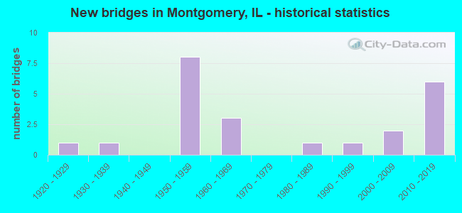
- New bridges - historical statistics
- 11920-1929
- 11930-1939
- 81950-1959
- 31960-1969
- 11980-1989
- 11990-1999
- 22000-2009
- 62010-2019

- Reconstructed bridges - Historical Statistics
- 11980-1989
- 31990-1999
- 52000-2009


- Bridge Condition - Deck
- 23.1%Very good
- 46.2%Good
- 30.8%Satisfactory

- Bridge Condition - Superstructure
- 30.8%Very good
- 30.8%Good
- 15.4%Satisfactory
- 23.1%Fair

- Bridge Condition - Substructure
- 23.1%Very good
- 53.8%Good
- 23.1%Satisfactory

- Bridge Condition - Channel
- 46.7%Very good
- 26.7%Good
- 20.0%Satisfactory
- 6.7%Fair
Find on map >> Show street view
Structure Number: 44001, Location: 1.7 MI N MASSAC CO (Lat: 37.358031, Lng: -88.886389), Route carried "on" structure: US 45, Year Built: 1920, Year Reconstructed: 2008, Status: Open, Structure Length: 1.61m (5.28ft), Average Daily Traffic: 2,100 (year 2021), Truck Traffic: 12%, Average Future Daily Traffic: 2,448 (year 2032), Design Load: HS 20, Features Intersected: CAVE CREEK
Minimum Vertical Clearance: 30+ m (98+ ft), Kilometerpoint: 42.469, Lanes on structure: 2, Base Highway Network: Yes, Owner: State Highway Agency, Approaching Roadway Width: 9.1m (29.9ft), Skew: 4 degrees, Material/Design: Prestressed concrete, Design/Construction: Box Beam or Girders - Multiple, Number Of Spans In Main Unit: 1, Length of Maximum Span: 15.5m (50.9ft), Curb-To-Curb Width: 9.7m (31.8ft), Out-to-Out Width: 10.1m (33.1ft)
Condition: Deck: Good, Superstructure: Satisfactory, Substructure: Satisfactory, Channel: Satisfactory, Operating Rating: 64.5 metric tons, Method Used To Determine Operating Rating: Load Factor (LF) rating reported by rating factor (RF) method using MS18 loading, Inventory Rating: 38.6 metric tons, Method Used To Determine Inventory Rating: Load Factor (LF) rating reported by rating factor (RF) method using MS18 loading, Structural Evaluation: Equal to present minimum criteria, Deck Geometry: Meets minimum limits, Waterway Adequacy: Equal to present desirable criteria, Approach Roadway Alignment: Equal to present desirable criteria, Designated Inspection Frequency: Every 24 months, Inspection Date: March 2020, Deck Structure Type: Concrete Precast Panels, Wearing Surface/Protective System: Wearing Surface: Integral Concrete, Membrane: Built-up, Deck Protection: Epoxy Coated Reinforcing
Find on map >> Show street view
Structure Number: 450039, Location: 3.3 M NW OF US 34 (Lat: 41.724519, Lng: -88.350572), Route carried "on" structure: US 30, Year Built: 1958, Year Reconstructed: 2014, Status: Open, Structure Length: 18.84m (61.81ft), Average Daily Traffic: 32,100 (year 2021), Truck Traffic: 12%, Average Future Daily Traffic: 31,772 (year 2032), Design Load: HS 20, Features Intersected: IL 31 & BNSF RR
Minimum Vertical Clearance: 30+ m (98+ ft), Kilometerpoint: 161.799, Lanes on structure: 4, Lanes under structure: 8, Base Highway Network: Yes, Owner: State Highway Agency, Approaching Roadway Width: 23.8m (78.1ft), Skew: 32 degrees, Material/Design: Steel continuous, Design/Construction: Stringer/Multi-beam, Number Of Spans In Main Unit: 10, Length of Maximum Span: 23.9m (78.4ft), Curb-To-Curb Width: 23.8m (78.1ft), Out-to-Out Width: 25.7m (84.3ft)
Condition: Deck: Satisfactory, Superstructure: Fair, Substructure: Good, Operating Rating: 83.6 metric tons, Method Used To Determine Operating Rating: Load Factor (LF) rating reported by rating factor (RF) method using MS18 loading, Inventory Rating: 49.9 metric tons, Method Used To Determine Inventory Rating: Load Factor (LF) rating reported by rating factor (RF) method using MS18 loading, Structural Evaluation: Somewhat better than minimum adequacy, Deck Geometry: Superior to present desirable criteria, Underclear: High priority of corrective action, Approach Roadway Alignment: Equal to present desirable criteria, Designated Inspection Frequency: Every 24 months, Inspection Date: October 2020, Deck Structure Type: Concrete Cast-file-Place, Wearing Surface/Protective System: Deck Protection: Epoxy Coated Reinforcing
Find on map >> Show street view
Structure Number: 450271, Location: W of IL31 No of US30 (Lat: 41.726192, Lng: -88.349653), Route carried "on" structure: Other road , Year Built: 2014, Status: Open, Structure Length: 0.76m (2.49ft), Average Daily Traffic: 2,000 (year 2014), Truck Traffic: 3%, Average Future Daily Traffic: 2,500 (year 2032), Design Load: HS 20, Features Intersected: STREAM, Facility Carried by Structure: US 30,IL31 RAMPS
Minimum Vertical Clearance: 30+ m (98+ ft), Kilometerpoint: 0.097, Lanes on structure: 2, Owner: State Highway Agency, Approaching Roadway Width: 24.4m (80.1ft), Skew: 30 degrees, Material/Design: Concrete, Design/Construction: Culvert, Number Of Spans In Main Unit: 3, Length of Maximum Span: 1.5m (4.9ft)
Condition: Channel: Very good, Culverts: Good, Operating Rating: 54.1 metric tons, Method Used To Determine Operating Rating: Assigned rating based on Load Factor Design (LFD) reported by rating factor (RF) using MS18 loading, Inventory Rating: 32.4 metric tons, Method Used To Determine Inventory Rating: Assigned rating based on Load Factor Design (LFD) reported by rating factor (RF) using MS18 loading, Structural Evaluation: Better than present minimum criteria, Waterway Adequacy: Equal to present desirable criteria, Approach Roadway Alignment: Equal to present desirable criteria, Designated Inspection Frequency: Every 48 months, Inspection Date: September 2020
Find on map >> Show street view
Structure Number: 450272, Location: under WB US30 ramp (Lat: 41.726153, Lng: -88.351344), Route carried "on" structure: Other road , Year Built: 2014, Status: Open, Structure Length: 2.96m (9.71ft), Average Daily Traffic: 2,000 (year 2014), Truck Traffic: 3%, Average Future Daily Traffic: 2,000 (year 2032), Design Load: HS 20, Features Intersected: STREAM, Facility Carried by Structure: IL 31 RMP 2 US30
Minimum Vertical Clearance: 30+ m (98+ ft), Kilometerpoint: 0.241, Lanes on structure: 2, Owner: State Highway Agency, Approaching Roadway Width: 4.9m (16.1ft), Material/Design: Concrete, Design/Construction: Culvert, Number Of Spans In Main Unit: 6, Length of Maximum Span: 2.1m (6.9ft), Curb-To-Curb Width: 4.9m (16.1ft), Out-to-Out Width: 5.5m (18.0ft)
Condition: Channel: Very good, Culverts: Good, Operating Rating: 89.1 metric tons, Method Used To Determine Operating Rating: Field evaluation and documented engineering judgment, Inventory Rating: 89.1 metric tons, Method Used To Determine Inventory Rating: Field evaluation and documented engineering judgment, Structural Evaluation: Better than present minimum criteria, Deck Geometry: High priority of replacement, Waterway Adequacy: Equal to present desirable criteria, Approach Roadway Alignment: Equal to present desirable criteria, Designated Inspection Frequency: Every 48 months, Inspection Date: September 2020
Find on map >> Show street view
Structure Number: 450274, Location: 200' W of IL31 (Lat: 41.724844, Lng: -88.351200), Route carried "on" structure: US 30, Year Built: 2014, Status: Open, Structure Length: 2.04m (6.69ft), Average Daily Traffic: 34,100 (year 2021), Truck Traffic: 12%, Average Future Daily Traffic: 33,600 (year 2036), Design Load: HS 20, Features Intersected: DITCH
Minimum Vertical Clearance: 30+ m (98+ ft), Kilometerpoint: 161.735, Lanes on structure: 6, Base Highway Network: Yes, Owner: State Highway Agency, Approaching Roadway Width: 13.7m (44.9ft), Material/Design: Concrete, Design/Construction: Culvert, Number Of Spans In Main Unit: 5, Length of Maximum Span: 1.8m (5.9ft)
Condition: Channel: Very good, Culverts: Good, Operating Rating: 89.1 metric tons, Method Used To Determine Operating Rating: Field evaluation and documented engineering judgment, Inventory Rating: 89.1 metric tons, Method Used To Determine Inventory Rating: Field evaluation and documented engineering judgment, Structural Evaluation: Better than present minimum criteria, Waterway Adequacy: Equal to present desirable criteria, Approach Roadway Alignment: Equal to present desirable criteria, Designated Inspection Frequency: Every 48 months, Inspection Date: September 2020
Find on map >> Show street view
Structure Number: 450275, Location: 300' S of US30 (Lat: 41.723950, Lng: -88.351219), Route carried "on" structure: State highway 31, Year Built: 2014, Status: Open, Structure Length: 1.77m (5.81ft), Average Daily Traffic: 15,000 (year 2021), Truck Traffic: 10%, Average Future Daily Traffic: 20,300 (year 2036), Design Load: HS 20, Features Intersected: DITCH
Minimum Vertical Clearance: 30+ m (98+ ft), Kilometerpoint: 4.442, Lanes on structure: 4, Base Highway Network: Yes, Owner: State Highway Agency, Approaching Roadway Width: 14.6m (47.9ft), Material/Design: Concrete, Design/Construction: Culvert, Number Of Spans In Main Unit: 5, Length of Maximum Span: 1.8m (5.9ft)
Condition: Channel: Very good, Culverts: Good, Operating Rating: 54.1 metric tons, Method Used To Determine Operating Rating: Field evaluation and documented engineering judgment, Inventory Rating: 32.4 metric tons, Method Used To Determine Inventory Rating: Field evaluation and documented engineering judgment, Structural Evaluation: Better than present minimum criteria, Waterway Adequacy: Equal to present desirable criteria, Approach Roadway Alignment: Equal to present desirable criteria, Designated Inspection Frequency: Every 48 months, Inspection Date: September 2020
Find on map >> Show street view
Structure Number: 452007, Location: JUST W. OF ILL 25 (Lat: 41.729622, Lng: -88.339519), Route carried "on" structure: Other road , Year Built: 1984, Status: Open, Structure Length: 8.69m (28.51ft), Average Daily Traffic: 5,950 (year 2018), Truck Traffic: 5%, Average Future Daily Traffic: 5,678 (year 2032), Design Load: HS 20, Features Intersected: FOX RIVER, Facility Carried by Structure: MILL ST.
Minimum Vertical Clearance: 30+ m (98+ ft), Kilometerpoint: 3.106, Lanes on structure: 2, Base Highway Network: Yes, Owner: City or Municipal Highway Agency, Approaching Roadway Width: 12.2m (40.0ft), Skew: 2 degrees, Material/Design: Prestressed concrete, Design/Construction: Stringer/Multi-beam, Number Of Spans In Main Unit: 4, Length of Maximum Span: 21.6m (70.9ft), Curb or Sidewalk Widths: Left: 1.5m (4.9ft), Right: 0.0m, Curb-To-Curb Width: 9.1m (29.9ft), Out-to-Out Width: 11.5m (37.7ft)
Condition: Deck: Good, Superstructure: Good, Substructure: Good, Channel: Good, Operating Rating: 74.8 metric tons, Method Used To Determine Operating Rating: Allowable Stress (AS) rating reported by rating factor (RF) method using MS18 loading, Inventory Rating: 37.9 metric tons, Method Used To Determine Inventory Rating: Allowable Stress (AS) rating reported by rating factor (RF) method using MS18 loading, Structural Evaluation: Better than present minimum criteria, Deck Geometry: Meets minimum limits, Waterway Adequacy: Superior to present desirable criteria, Approach Roadway Alignment: Equal to present desirable criteria, Designated Inspection Frequency: Every 48 months, Inspection Date: June 2020, Deck Structure Type: Concrete Cast-file-Place, Wearing Surface/Protective System: Wearing Surface: Latex Concrete, Deck Protection: Epoxy Coated Reinforcing
Find on map >> Show street view
Structure Number: 452023, Location: 0.5 M N OF US 34 (Lat: 41.726928, Lng: -88.284886), Route carried "on" structure: Other road , Year Built: 2003, Status: Open, Structure Length: 2.56m (8.40ft), Average Daily Traffic: 14,000 (year 2021), Truck Traffic: 5%, Average Future Daily Traffic: 17,354 (year 2032), Design Load: HS 20, Features Intersected: WAUBANSEE CREEK, Facility Carried by Structure: HILL AVE (AURORA)
Minimum Vertical Clearance: 30+ m (98+ ft), Kilometerpoint: 48.842, Lanes on structure: 2, Base Highway Network: Yes, Owner: State Highway Agency, Approaching Roadway Width: 9.6m (31.5ft), Material/Design: Steel, Design/Construction: Stringer/Multi-beam, Number Of Spans In Main Unit: 1, Length of Maximum Span: 24.8m (81.4ft), Curb-To-Curb Width: 12.0m (39.4ft), Out-to-Out Width: 13.0m (42.7ft)
Condition: Deck: Good, Superstructure: Very good, Substructure: Very good, Channel: Satisfactory, Operating Rating: 65.4 metric tons, Method Used To Determine Operating Rating: Load Factor (LF) rating reported by rating factor (RF) method using MS18 loading, Inventory Rating: 39.2 metric tons, Method Used To Determine Inventory Rating: Load Factor (LF) rating reported by rating factor (RF) method using MS18 loading, Structural Evaluation: Equal to present desirable criteria, Deck Geometry: Somewhat better than minimum adequacy, Waterway Adequacy: Equal to present desirable criteria, Approach Roadway Alignment: Equal to present desirable criteria, Designated Inspection Frequency: Every 48 months, Inspection Date: July 2018, Deck Structure Type: Concrete Cast-file-Place, Wearing Surface/Protective System: Deck Protection: Epoxy Coated Reinforcing
Find on map >> Show street view
Structure Number: 45319, Location: 3.2 MI E RTE 47 (Lat: 41.740822, Lng: -88.383314), Route carried "on" structure: Other road , Year Built: 2015, Status: Open, Structure Length: 3.48m (11.42ft), Average Daily Traffic: 4,900 (year 2018), Truck Traffic: 4%, Average Future Daily Traffic: 5,297 (year 2032), Design Load: HS 25 or greater, Features Intersected: BLACKBERRY CREEK, Facility Carried by Structure: JERICHO ROAD
Minimum Vertical Clearance: 30+ m (98+ ft), Kilometerpoint: 9.253, Lanes on structure: 2, Base Highway Network: Yes, Owner: County Highway Agency, Approaching Roadway Width: 16.2m (53.1ft), Material/Design: Prestressed concrete, Design/Construction: Box Beam or Girders - Multiple, Number Of Spans In Main Unit: 2, Length of Maximum Span: 16.7m (54.8ft), Curb-To-Curb Width: 16.2m (53.1ft), Out-to-Out Width: 17.1m (56.1ft)
Condition: Deck: Very good, Superstructure: Very good, Substructure: Very good, Channel: Very good, Operating Rating: 54.1 metric tons, Method Used To Determine Operating Rating: Load and Resistance Factor Rating (LRFR) rating reported by rating factor(RF) method using HL-93 loadings, Inventory Rating: 42.4 metric tons, Method Used To Determine Inventory Rating: Load and Resistance Factor Rating (LRFR) rating reported by rating factor(RF) method using HL-93 loadings, Structural Evaluation: Equal to present desirable criteria, Deck Geometry: Superior to present desirable criteria, Waterway Adequacy: Equal to present desirable criteria, Approach Roadway Alignment: Equal to present desirable criteria, Designated Inspection Frequency: Every 48 months, Inspection Date: January 2018, Deck Structure Type: Concrete Precast Panels, Wearing Surface/Protective System: Wearing Surface: Integral Concrete, Deck Protection: Epoxy Coated Reinforcing
Find on map >> Show street view
Structure Number: 456003, Location: 100 FT W ILL RTE 25 (Lat: 41.737989, Lng: -88.330244), Route carried "on" structure: Other road , Year Built: 1961, Year Reconstructed: 1997, Status: Open, Structure Length: 5.48m (17.98ft), Average Daily Traffic: 1,000 (year 2018), Truck Traffic: 14%, Average Future Daily Traffic: 1,085 (year 2032), Design Load: HS 20, Features Intersected: E BRANCH OF FOX RV, Facility Carried by Structure: ASHLAND AV
Minimum Vertical Clearance: 30+ m (98+ ft), Kilometerpoint: 0.370, Lanes on structure: 4, Owner: Town or Township Highway Agency, Approaching Roadway Width: 14.6m (47.9ft), Skew: 2 degrees, Material/Design: Steel continuous, Design/Construction: Stringer/Multi-beam, Number Of Spans In Main Unit: 2, Length of Maximum Span: 34.1m (111.9ft), Curb or Sidewalk Widths: Left: 1.5m (4.9ft), Right: 1.5m (4.9ft), Curb-To-Curb Width: 14.6m (47.9ft), Out-to-Out Width: 18.3m (60.0ft)
Condition: Deck: Satisfactory, Superstructure: Satisfactory, Substructure: Satisfactory, Channel: Good, Operating Rating: 51.2 metric tons, Method Used To Determine Operating Rating: Load Factor (LF) rating reported by rating factor (RF) method using MS18 loading, Inventory Rating: 30.8 metric tons, Method Used To Determine Inventory Rating: Load Factor (LF) rating reported by rating factor (RF) method using MS18 loading, Structural Evaluation: Equal to present minimum criteria, Deck Geometry: High priority of replacement, Waterway Adequacy: Equal to present desirable criteria, Approach Roadway Alignment: Equal to present desirable criteria, Length Of Structure Improvement: 6.55m (21.49ft), Designated Inspection Frequency: Every 24 months, Underwater Inspection Frequency: Every 60 months, Inspection Date: March 2020, Underwater Inspection Date: March 2020, Bridge Improvement Cost: $1,134,000, Roadway Improvement Cost: $113,000, Total Project Cost: $1,701,000, Deck Structure Type: Concrete Cast-file-Place, Wearing Surface/Protective System: Deck Protection: Epoxy Coated Reinforcing
Find on map >> Show street view
Structure Number: 456004, Location: 400 FT W ILL RTE 25 (Lat: 41.737911, Lng: -88.331447), Route carried "on" structure: Other road , Year Built: 1961, Year Reconstructed: 1997, Status: Open, Structure Length: 6.41m (21.03ft), Average Daily Traffic: 1,000 (year 2018), Truck Traffic: 14%, Average Future Daily Traffic: 1,085 (year 2032), Design Load: HS 20, Features Intersected: W BRANCH OF FOX RV, Facility Carried by Structure: ASHLAND AVENUE
Minimum Vertical Clearance: 30+ m (98+ ft), Kilometerpoint: 0.274, Lanes on structure: 4, Owner: Town or Township Highway Agency, Approaching Roadway Width: 14.6m (47.9ft), Skew: 2 degrees, Material/Design: Steel continuous, Design/Construction: Stringer/Multi-beam, Number Of Spans In Main Unit: 3, Length of Maximum Span: 23.8m (78.1ft), Curb or Sidewalk Widths: Left: 1.5m (4.9ft), Right: 1.5m (4.9ft), Curb-To-Curb Width: 14.6m (47.9ft), Out-to-Out Width: 18.3m (60.0ft)
Condition: Deck: Satisfactory, Superstructure: Good, Substructure: Satisfactory, Channel: Very good, Operating Rating: 78.4 metric tons, Method Used To Determine Operating Rating: Load Factor (LF) rating reported by rating factor (RF) method using MS18 loading, Inventory Rating: 45.0 metric tons, Method Used To Determine Inventory Rating: Load Factor (LF) rating reported by rating factor (RF) method using MS18 loading, Structural Evaluation: Equal to present minimum criteria, Deck Geometry: High priority of replacement, Waterway Adequacy: Equal to present desirable criteria, Approach Roadway Alignment: Equal to present desirable criteria, Length Of Structure Improvement: 7.68m (25.20ft), Designated Inspection Frequency: Every 24 months, Underwater Inspection Frequency: Every 60 months, Inspection Date: March 2020, Underwater Inspection Date: March 2020, Bridge Improvement Cost: $1,331,000, Roadway Improvement Cost: $133,000, Total Project Cost: $1,997,000, Deck Structure Type: Concrete Cast-file-Place, Wearing Surface/Protective System: Deck Protection: Epoxy Coated Reinforcing
Find on map >> Show street view
Structure Number: 4564, Location: 0.675 MI N US 30 (Lat: 41.732344, Lng: -88.375517), Route carried "on" structure: Other road , Year Built: 2012, Status: Open, Structure Length: 2.03m (6.66ft), Average Daily Traffic: 30,500 (year 2018), Truck Traffic: 9%, Average Future Daily Traffic: 56,000 (year 2042), Design Load: HS 20, Features Intersected: BLACKBERRY CRK OVRFL, Facility Carried by Structure: ORCHARD ROAD
Minimum Vertical Clearance: 30+ m (98+ ft), Kilometerpoint: 48.408, Lanes on structure: 4, Base Highway Network: Yes, Owner: County Highway Agency, Approaching Roadway Width: 21.9m (71.9ft), Skew: 35 degrees, Material/Design: Concrete, Design/Construction: Culvert, Number Of Spans In Main Unit: 5, Length of Maximum Span: 4.0m (13.1ft), Curb or Sidewalk Widths: Left: 3.0m (9.8ft), Right: 0.0m, Curb-To-Curb Width: 24.4m (80.1ft), Out-to-Out Width: 39.4m (129.3ft)
Condition: Channel: Very good, Culverts: Good, Operating Rating: 79.7 metric tons, Method Used To Determine Operating Rating: Load Factor (LF) rating reported by rating factor (RF) method using MS18 loading, Inventory Rating: 47.6 metric tons, Method Used To Determine Inventory Rating: Load Factor (LF) rating reported by rating factor (RF) method using MS18 loading, Structural Evaluation: Better than present minimum criteria, Deck Geometry: Superior to present desirable criteria, Waterway Adequacy: Equal to present desirable criteria, Approach Roadway Alignment: Equal to present desirable criteria, Designated Inspection Frequency: Every 24 months, Inspection Date: January 2020, Deck Structure Type: Concrete Cast-file-Place
Find on map >> Show street view
Structure Number: 470006, Location: 0.5 M S OF US 30 (Lat: 41.716750, Lng: -88.355481), Route carried "on" structure: State highway 31, Year Built: 1960, Year Reconstructed: 1990, Status: Open, Structure Length: 10.66m (34.97ft), Average Daily Traffic: 11,200 (year 2019), Truck Traffic: 6%, Average Future Daily Traffic: 19,710 (year 2032), Design Load: HS 20, Features Intersected: RR - BNSF
Minimum Vertical Clearance: 30+ m (98+ ft), Kilometerpoint: 3.508, Lanes on structure: 4, Base Highway Network: Yes, Owner: State Highway Agency, Approaching Roadway Width: 21.9m (71.9ft), Skew: 36 degrees, Material/Design: Steel continuous, Design/Construction: Stringer/Multi-beam, Number Of Spans In Main Unit: 5, Length of Maximum Span: 33.5m (109.9ft), Curb-To-Curb Width: 19.4m (63.6ft), Out-to-Out Width: 21.2m (69.6ft)
Condition: Deck: Good, Superstructure: Good, Substructure: Good, Operating Rating: 89.1 metric tons, Method Used To Determine Operating Rating: Load Factor (LF) rating reported by rating factor (RF) method using MS18 loading, Inventory Rating: 52.8 metric tons, Method Used To Determine Inventory Rating: Load Factor (LF) rating reported by rating factor (RF) method using MS18 loading, Structural Evaluation: Better than present minimum criteria, Deck Geometry: Better than present minimum criteria, Underclear: Better than present minimum criteria, Approach Roadway Alignment: Equal to present desirable criteria, Designated Inspection Frequency: Every 24 months, Inspection Date: Febuary 2020, Deck Structure Type: Concrete Cast-file-Place, Wearing Surface/Protective System: Wearing Surface: Latex Concrete, Deck Protection: Epoxy Coated Reinforcing
Find on map >> Show street view
Structure Number: 470029, Location: 0.1 M W OF ORCHARD (Lat: 41.722619, Lng: -88.376681), Route carried "on" structure: US 30, Year Built: 1956, Year Reconstructed: 1991, Status: Open, Structure Length: 2.75m (9.02ft), Average Daily Traffic: 19,300 (year 2021), Truck Traffic: 5%, Average Future Daily Traffic: 14,162 (year 2032), Design Load: HS 20, Features Intersected: BLACKBERRY CREEK
Minimum Vertical Clearance: 30+ m (98+ ft), Kilometerpoint: 159.546, Lanes on structure: 2, Base Highway Network: Yes, Owner: State Highway Agency, Approaching Roadway Width: 17.1m (56.1ft), Material/Design: Steel continuous, Design/Construction: Stringer/Multi-beam, Number Of Spans In Main Unit: 2, Length of Maximum Span: 13.2m (43.3ft), Curb-To-Curb Width: 17.1m (56.1ft), Out-to-Out Width: 18.0m (59.1ft)
Condition: Deck: Good, Superstructure: Fair, Substructure: Good, Channel: Satisfactory, Operating Rating: 62.5 metric tons, Method Used To Determine Operating Rating: Load Factor (LF) rating reported by rating factor (RF) method using MS18 loading, Inventory Rating: 33.7 metric tons, Method Used To Determine Inventory Rating: Load Factor (LF) rating reported by rating factor (RF) method using MS18 loading, Structural Evaluation: Somewhat better than minimum adequacy, Deck Geometry: Superior to present desirable criteria, Waterway Adequacy: Better than present minimum criteria, Approach Roadway Alignment: Equal to present desirable criteria, Length Of Structure Improvement: 3.57m (11.71ft), Designated Inspection Frequency: Every 24 months, Other Special Inspection Frequency: Every 24 months, Inspection Date: November 2021, Other Special Inspection Date: November 2021, Bridge Improvement Cost: $416,000, Roadway Improvement Cost: $42,000, Total Project Cost: $624,000, Deck Structure Type: Concrete Cast-file-Place, Wearing Surface/Protective System: Deck Protection: Epoxy Coated Reinforcing
Find on map >> Show street view
Structure Number: 47003, Location: 4.5 M E OF IL 47 (Lat: 41.722839, Lng: -88.347292), Route carried "on" structure: US 30, Year Built: 1958, Year Reconstructed: 2000, Status: Open, Structure Length: 3.63m (11.91ft), Average Daily Traffic: 32,100 (year 2021), Truck Traffic: 12%, Average Future Daily Traffic: 44,822 (year 2032), Design Load: HS 20, Features Intersected: RIVER ST(MONTGOMERY)
Minimum Vertical Clearance: 30+ m (98+ ft), Kilometerpoint: 162.169, Lanes on structure: 4, Lanes under structure: 2, Base Highway Network: Yes, Owner: State Highway Agency, Approaching Roadway Width: 18.4m (60.4ft), Skew: 30 degrees, Material/Design: Steel continuous, Design/Construction: Stringer/Multi-beam, Number Of Spans In Main Unit: 3, Length of Maximum Span: 13.9m (45.6ft), Curb-To-Curb Width: 18.4m (60.4ft), Out-to-Out Width: 21.8m (71.5ft)
Condition: Deck: Satisfactory, Superstructure: Fair, Substructure: Good, Operating Rating: 66.4 metric tons, Method Used To Determine Operating Rating: Load Factor (LF) rating reported by rating factor (RF) method using MS18 loading, Inventory Rating: 39.9 metric tons, Method Used To Determine Inventory Rating: Load Factor (LF) rating reported by rating factor (RF) method using MS18 loading, Structural Evaluation: Somewhat better than minimum adequacy, Deck Geometry: Somewhat better than minimum adequacy, Underclear: High priority of corrective action, Approach Roadway Alignment: Equal to present desirable criteria, Designated Inspection Frequency: Every 24 months, Inspection Date: April 2020, Deck Structure Type: Concrete Cast-file-Place, Wearing Surface/Protective System: Deck Protection: Epoxy Coated Reinforcing
Find on map >> Show street view
Structure Number: 470031, Location: US RTE 30 & FOX RIV (Lat: 41.722369, Lng: -88.346347), Route carried "on" structure: US 30, Year Built: 1957, Year Reconstructed: 2000, Status: Open, Structure Length: 30.01m (98.46ft), Average Daily Traffic: 32,100 (year 2021), Truck Traffic: 12%, Average Future Daily Traffic: 44,822 (year 2032), Design Load: HS 20, Features Intersected: FOX RIVER & IL 25
Minimum Vertical Clearance: 30+ m (98+ ft), Kilometerpoint: 162.282, Lanes on structure: 4, Lanes under structure: 2, Base Highway Network: Yes, Owner: State Highway Agency, Approaching Roadway Width: 17.6m (57.7ft), Skew: 30 degrees, Material/Design: Steel continuous, Design/Construction: Stringer/Multi-beam, Number Of Spans In Main Unit: 7, Length of Maximum Span: 45.7m (149.9ft), Curb-To-Curb Width: 17.6m (57.7ft), Out-to-Out Width: 20.7m (67.9ft)
Condition: Deck: Good, Superstructure: Good, Substructure: Good, Channel: Good, Operating Rating: 63.5 metric tons, Method Used To Determine Operating Rating: Load Factor (LF) rating reported by rating factor (RF) method using MS18 loading, Inventory Rating: 38.2 metric tons, Method Used To Determine Inventory Rating: Load Factor (LF) rating reported by rating factor (RF) method using MS18 loading, Structural Evaluation: Better than present minimum criteria, Deck Geometry: Somewhat better than minimum adequacy, Waterway Adequacy: Superior to present desirable criteria, Approach Roadway Alignment: Equal to present desirable criteria, Length Of Structure Improvement: 29.87m (98.00ft), Designated Inspection Frequency: Every 24 months, Inspection Date: October 2021, Bridge Improvement Cost: $2,717,000, Roadway Improvement Cost: $272,000, Total Project Cost: $4,076,000, Deck Structure Type: Concrete Cast-file-Place, Wearing Surface/Protective System: Deck Protection: Epoxy Coated Reinforcing
Find on map >> Show street view
Structure Number: 473146, Location: .1 MI N OF GALENA RD (Lat: 41.703097, Lng: -88.405194), Route carried "on" structure: County highway , Year Built: 1996, Year Reconstructed: 2012, Status: Open, Structure Length: 3.16m (10.37ft), Average Daily Traffic: 675 (year 2019), Truck Traffic: 6%, Average Future Daily Traffic: 1,533 (year 2032), Design Load: HS 20, Features Intersected: BLACKBERRY CREEK, Facility Carried by Structure: WILLOW LANE
Minimum Vertical Clearance: 30+ m (98+ ft), Kilometerpoint: 0.467, Lanes on structure: 2, Owner: Town or Township Highway Agency, Approaching Roadway Width: 9.1m (29.9ft), Material/Design: Prestressed concrete, Design/Construction: Box Beam or Girders - Multiple, Number Of Spans In Main Unit: 3, Length of Maximum Span: 10.4m (34.1ft), Curb-To-Curb Width: 9.1m (29.9ft), Out-to-Out Width: 9.1m (29.9ft)
Condition: Deck: Very good, Superstructure: Very good, Substructure: Good, Channel: Fair, Operating Rating: 42.1 metric tons, Method Used To Determine Operating Rating: Load and Resistance Factor Rating (LRFR) rating reported by rating factor(RF) method using HL-93 loadings, Inventory Rating: 32.4 metric tons, Method Used To Determine Inventory Rating: Load and Resistance Factor Rating (LRFR) rating reported by rating factor(RF) method using HL-93 loadings, Structural Evaluation: Better than present minimum criteria, Deck Geometry: Equal to present minimum criteria, Waterway Adequacy: Equal to present minimum criteria, Approach Roadway Alignment: Equal to present desirable criteria, Designated Inspection Frequency: Every 48 months, Inspection Date: December 2019, Deck Structure Type: Concrete Precast Panels, Wearing Surface/Protective System: Wearing Surface: Bituminous, Membrane: Other
Find on map >> Show street view
Structure Number: 476601, Location: 0.2 mi NW Galena Rd (Lat: 41.712411, Lng: -88.389411), Route carried "on" structure: Other road , Year Built: 2002, Status: Open, Structure Length: 4.83m (15.85ft), Average Daily Traffic: 4,300 (year 2019), Truck Traffic: 4%, Average Future Daily Traffic: 5,037 (year 2032), Design Load: HS 20, Features Intersected: BLACKBERRY CREEK, Facility Carried by Structure: CONCORD DRIVE
Minimum Vertical Clearance: 30+ m (98+ ft), Kilometerpoint: 4.924, Lanes on structure: 2, Owner: City or Municipal Highway Agency, Approaching Roadway Width: 9.8m (32.2ft), Material/Design: Prestressed concrete, Design/Construction: Stringer/Multi-beam, Number Of Spans In Main Unit: 3, Length of Maximum Span: 18.9m (62.0ft), Curb or Sidewalk Widths: Left: 1.5m (4.9ft), Right: 3.0m (9.8ft), Curb-To-Curb Width: 9.8m (32.2ft), Out-to-Out Width: 15.8m (51.8ft)
Condition: Deck: Very good, Superstructure: Very good, Substructure: Very good, Channel: Good, Operating Rating: 44.1 metric tons, Method Used To Determine Operating Rating: Assigned rating based on Load Factor Design (LFD) reported by rating factor (RF) using MS18 loading, Inventory Rating: 32.4 metric tons, Method Used To Determine Inventory Rating: Assigned rating based on Load Factor Design (LFD) reported by rating factor (RF) using MS18 loading, Structural Evaluation: Equal to present desirable criteria, Deck Geometry: Meets minimum limits, Waterway Adequacy: Superior to present desirable criteria, Approach Roadway Alignment: Equal to present minimum criteria, Designated Inspection Frequency: Every 48 months, Inspection Date: June 2020, Deck Structure Type: Concrete Cast-file-Place, Wearing Surface/Protective System: Wearing Surface: Epoxy Overlay, Deck Protection: Epoxy Coated Reinforcing
Find on map >> Show street view
Structure Number: 450039, Location: 3.3 M NW OF US 34 (Lat: 41.724392, Lng: -88.350333), Route carried "under" structure: State highway 31, Year Built: 1958, Structure Length: 0. m, Average Daily Traffic: 16,800 (year 2021), Truck Traffic: 11%, Features Intersected: IL 31 & BNSF RR, Facility Carried by Structure: US 30
Minimum Vertical Clearance: 8.31m (27.26ft), Kilometerpoint: 4.538, Lanes on structure: 4, Lanes under structure: 6, Material/Design: Steel continuous, Design/Construction: Stringer/Multi-beam, Length of Maximum Span: 23.9m (78.4ft)
Find on map >> Show street view
Structure Number: 450039, Location: 3.3 M NW OF US 34 (Lat: 41.723703, Lng: -88.349019), Route carried "under" structure: City street , Year Built: 1958, Structure Length: 0. m, Average Daily Traffic: 225 (year 2018), Truck Traffic: 15%, Features Intersected: IL 31 & BNSF RR, Facility Carried by Structure: US 30
Minimum Vertical Clearance: 0.28m (0.92ft), Kilometerpoint: 0.209, Lanes on structure: 4, Lanes under structure: 2, Material/Design: Steel continuous, Design/Construction: Stringer/Multi-beam, Length of Maximum Span: 23.9m (78.4ft)
Find on map >> Show street view
Structure Number: 47003, Location: 4.5 M E OF IL 47 (Lat: 41.722625, Lng: -88.346861), Route carried "under" structure: City street , Year Built: 1958, Structure Length: 0. m, Average Daily Traffic: 300 (year 2013), Features Intersected: RIVER ST(MONTGOMERY), Facility Carried by Structure: US 30
Minimum Vertical Clearance: 30+ m (98+ ft), Kilometerpoint: 0.724, Lanes on structure: 4, Lanes under structure: 2, Material/Design: Steel continuous, Design/Construction: Stringer/Multi-beam, Length of Maximum Span: 13.9m (45.6ft)
Find on map >> Show street view
Structure Number: 470031, Location: US RTE 30 & FOX RIV (Lat: 41.720678, Lng: -88.343050), Route carried "under" structure: State highway 25, Year Built: 1957, Structure Length: 0. m, Average Daily Traffic: 4,450 (year 2021), Truck Traffic: 2%, Features Intersected: FOX RIVER & IL 25, Facility Carried by Structure: US 30
Minimum Vertical Clearance: 6.40m (21.00ft), Kilometerpoint: 4.265, Lanes on structure: 4, Lanes under structure: 2, Material/Design: Steel continuous, Design/Construction: Stringer/Multi-beam, Length of Maximum Span: 45.7m (149.9ft)
Find on map >> Show street view
Structure Number: 47004, Location: .49 MI S OF US 30 (Lat: 41.715183, Lng: -88.348819), Route carried "under" structure: State highway 25, Year Built: 1938, Structure Length: 0. m, Average Daily Traffic: 4,450 (year 2021), Truck Traffic: 2%, Features Intersected: IL 25 & RIVER, Facility Carried by Structure: B.N. RR
Minimum Vertical Clearance: 4.06m (13.32ft), Kilometerpoint: 3.492, Lanes under structure: 2, Material/Design: Steel, Design/Construction: Stringer/Multi-beam, Length of Maximum Span: 13.1m (43.0ft)