Bridge Statistics for Montebello, California (CA)
Condition, Traffic, Stress, Structural Evaluation, Project Costs
- National Bridge Inventory (NBI) Statistics
- 17Number of bridges
- 177ft / 53.9mTotal length
- $3,178,000Total costs
- 1,140,442Total average daily traffic
- 40,923Total average daily truck traffic
- National Bridge Inventory (NBI) Registered Bridges for Montebello
- No street view available for this location
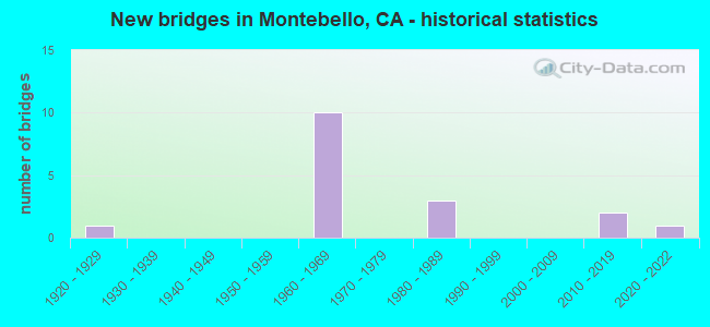
- New bridges - historical statistics
- 11920-1929
- 101960-1969
- 31980-1989
- 22010-2019
- 12020-2022


- Bridge Condition - Deck
- 66.7%Good
- 33.3%Fair

- Bridge Condition - Superstructure
- 88.9%Good
- 11.1%Fair
Find on map >> Show street view
Structure Number: 53 1694, Location: 07-LA-060-R5.89-MTBL (Lat: 34.033022, Lng: -118.125322), Route carried "on" structure: State highway 60, Year Built: 1967, Status: Open, Structure Length: 4.54m (14.90ft), Average Daily Traffic: 250,000 (year 2019), Truck Traffic: 7%, Average Future Daily Traffic: 269,337 (year 2040), Design Load: HS 20, Features Intersected: WILCOX AVENUE
Minimum Vertical Clearance: 30+ m (98+ ft), Kilometerpoint: 5.890, Lanes on structure: 8, Lanes under structure: 6, Base Highway Network: Yes (, Subroute: 1), Owner: State Highway Agency, Approaching Roadway Width: 40.2m (131.9ft), Skew: 30 degrees, Material/Design: Concrete continuous, Design/Construction: Box Beam or Girders - Multiple, Number Of Spans In Main Unit: 3, Length of Maximum Span: 25.3m (83.0ft), Curb-To-Curb Width: 40.4m (132.5ft), Out-to-Out Width: 41.7m (136.8ft)
Condition: Deck: Fair, Superstructure: Good, Substructure: Good, Operating Rating: 29.8 metric tons, Method Used To Determine Operating Rating: Load and Resistance Factor Rating (LRFR) rating reported by rating factor(RF) method using HL-93 loadings, Inventory Rating: 23.0 metric tons, Method Used To Determine Inventory Rating: Load and Resistance Factor Rating (LRFR) rating reported by rating factor(RF) method using HL-93 loadings, Structural Evaluation: Somewhat better than minimum adequacy, Deck Geometry: Superior to present desirable criteria, Underclear: Somewhat better than minimum adequacy, Approach Roadway Alignment: Equal to present desirable criteria, Length Of Structure Improvement: 4.54m (14.90ft), Designated Inspection Frequency: Every 24 months, Inspection Date: April 2021, Bridge Improvement Cost: $1,892,000, Roadway Improvement Cost: $378,000, Total Project Cost: $3,178,000 ( Estimate for 2020), Deck Structure Type: Concrete Cast-file-Place
Find on map >> Show street view
Structure Number: 53 1695, Location: 07-LA-060-R5.60-MTBL (Lat: 34.032972, Lng: -118.130350), Route carried "on" structure: State highway 60, Year Built: 1967, Status: Open, Structure Length: 5.70m (18.70ft), Average Daily Traffic: 250,000 (year 2019), Truck Traffic: 7%, Average Future Daily Traffic: 289,337 (year 2039), Design Load: HS 20, Features Intersected: GARFIELD AVE
Minimum Vertical Clearance: 30+ m (98+ ft), Kilometerpoint: 5.600, Lanes on structure: 8, Lanes under structure: 5, Base Highway Network: Yes (, Subroute: 1), Owner: State Highway Agency, Approaching Roadway Width: 39.9m (130.9ft), Skew: 30 degrees, Material/Design: Concrete continuous, Design/Construction: Box Beam or Girders - Multiple, Number Of Spans In Main Unit: 3, Length of Maximum Span: 31.4m (103.0ft), Curb-To-Curb Width: 40.4m (132.5ft), Out-to-Out Width: 41.6m (136.5ft)
Condition: Deck: Fair, Superstructure: Good, Substructure: Good, Operating Rating: 48.0 metric tons, Method Used To Determine Operating Rating: Load and Resistance Factor Rating (LRFR) rating reported by rating factor(RF) method using HL-93 loadings, Inventory Rating: 36.9 metric tons, Method Used To Determine Inventory Rating: Load and Resistance Factor Rating (LRFR) rating reported by rating factor(RF) method using HL-93 loadings, Structural Evaluation: Better than present minimum criteria, Deck Geometry: Superior to present desirable criteria, Underclear: Equal to present minimum criteria, Approach Roadway Alignment: Equal to present desirable criteria, Designated Inspection Frequency: Every 24 months, Inspection Date: April 2021, Deck Structure Type: Concrete Cast-file-Place
Find on map >> Show street view
Structure Number: 53 1700S, Location: 07-LA-170-R17.13-LA (Lat: 34.185453, Lng: -118.400136), Route carried "on" structure: Ramp State highway 170, Year Built: 1966, Status: Open, Structure Length: 3.54m (11.61ft), Average Daily Traffic: 3,000 (year 2017), Truck Traffic: 5%, Average Future Daily Traffic: 4,430 (year 2040), Design Load: HS 20, Features Intersected: N170-VICTORY BL OFF-RAMP
Minimum Vertical Clearance: 30+ m (98+ ft), Kilometerpoint: 17.130, Lanes on structure: 1, Lanes under structure: 2, Base Highway Network: Yes (Inventory Route: 1, Subroute: 1), Owner: State Highway Agency, Approaching Roadway Width: 7.6m (24.9ft), Material/Design: Concrete continuous, Design/Construction: Box Beam or Girders - Single/Spread, Number Of Spans In Main Unit: 3, Length of Maximum Span: 18.3m (60.0ft), Curb or Sidewalk Widths: Left: 0.6m (2.0ft), Right: 0.0m, Curb-To-Curb Width: 7.6m (24.9ft), Out-to-Out Width: 8.9m (29.2ft)
Condition: Deck: Good, Superstructure: Good, Substructure: Good, Operating Rating: 33.7 metric tons, Method Used To Determine Operating Rating: Load and Resistance Factor Rating (LRFR) rating reported by rating factor(RF) method using HL-93 loadings, Inventory Rating: 25.9 metric tons, Method Used To Determine Inventory Rating: Load and Resistance Factor Rating (LRFR) rating reported by rating factor(RF) method using HL-93 loadings, Structural Evaluation: Equal to present minimum criteria, Deck Geometry: Better than present minimum criteria, Underclear: Meets minimum limits, Approach Roadway Alignment: Equal to present minimum criteria, Designated Inspection Frequency: Every 24 months, Inspection Date: March 2020, Deck Structure Type: Concrete Cast-file-Place
Find on map >> Show street view
Structure Number: 53 1709, Location: 07-LA-060-R6.30-MTBL (Lat: 34.033097, Lng: -118.118217), Route carried "on" structure: State highway 60, Year Built: 1967, Status: Open, Structure Length: 4.05m (13.29ft), Average Daily Traffic: 232,000 (year 2019), Average Future Daily Traffic: 230,123 (year 2040), Design Load: HS 20, Features Intersected: MARKLAND DRIVE
Minimum Vertical Clearance: 30+ m (98+ ft), Kilometerpoint: 6.300, Lanes on structure: 8, Lanes under structure: 5, Base Highway Network: Yes (, Subroute: 1), Owner: State Highway Agency, Approaching Roadway Width: 40.2m (131.9ft), Skew: 30 degrees, Material/Design: Concrete continuous, Design/Construction: Box Beam or Girders - Multiple, Number Of Spans In Main Unit: 3, Length of Maximum Span: 18.9m (62.0ft), Curb-To-Curb Width: 40.4m (132.5ft), Out-to-Out Width: 41.7m (136.8ft)
Condition: Deck: Good, Superstructure: Good, Substructure: Good, Operating Rating: 39.9 metric tons, Method Used To Determine Operating Rating: Load and Resistance Factor Rating (LRFR) rating reported by rating factor(RF) method using HL-93 loadings, Inventory Rating: 30.8 metric tons, Method Used To Determine Inventory Rating: Load and Resistance Factor Rating (LRFR) rating reported by rating factor(RF) method using HL-93 loadings, Structural Evaluation: Better than present minimum criteria, Deck Geometry: Superior to present desirable criteria, Underclear: Meets minimum limits, Approach Roadway Alignment: Equal to present desirable criteria, Designated Inspection Frequency: Every 24 months, Inspection Date: April 2021, Deck Structure Type: Concrete Cast-file-Place
Find on map >> Show street view
Structure Number: 53 1709K, Location: 07-LA-060-R6.30-MTBL (Lat: 34.033547, Lng: -118.118219), Route carried "on" structure: Bypass State highway 60, Year Built: 1967, Status: Open, Structure Length: 4.05m (13.29ft), Average Daily Traffic: 17,000 (year 2019), Truck Traffic: 5%, Average Future Daily Traffic: 21,608 (year 2040), Design Load: HS 20, Features Intersected: MARKLAND DR
Minimum Vertical Clearance: 30+ m (98+ ft), Kilometerpoint: 6.300, Lanes on structure: 1, Lanes under structure: 5, Base Highway Network: Yes (, Subroute: 1), Owner: State Highway Agency, Approaching Roadway Width: 6.7m (22.0ft), Material/Design: Concrete continuous, Design/Construction: Box Beam or Girders - Multiple, Number Of Spans In Main Unit: 3, Length of Maximum Span: 18.9m (62.0ft), Curb or Sidewalk Widths: Left: 0.0m, Right: 0.6m (2.0ft), Curb-To-Curb Width: 6.8m (22.3ft), Out-to-Out Width: 8.0m (26.2ft)
Condition: Deck: Good, Superstructure: Good, Substructure: Good, Operating Rating: 33.7 metric tons, Method Used To Determine Operating Rating: Load and Resistance Factor Rating (LRFR) rating reported by rating factor(RF) method using HL-93 loadings, Inventory Rating: 25.9 metric tons, Method Used To Determine Inventory Rating: Load and Resistance Factor Rating (LRFR) rating reported by rating factor(RF) method using HL-93 loadings, Structural Evaluation: Equal to present minimum criteria, Deck Geometry: High priority of replacement, Underclear: Meets minimum limits, Approach Roadway Alignment: Equal to present desirable criteria, Designated Inspection Frequency: Every 24 months, Inspection Date: April 2021, Deck Structure Type: Concrete Cast-file-Place
Find on map >> Show street view
Structure Number: 53 3071K, Location: 07-LA-005-5.12 (Lat: 33.918833, Lng: -118.081667), Route carried "on" structure: Ramp Interstate 5, Year Built: 2020, Status: Open, Structure Length: 6.55m (21.49ft), Average Daily Traffic: 12,000 (year 2021), Truck Traffic: 2%, Average Future Daily Traffic: 18,000 (year 2040), Design Load: HL 93, Features Intersected: PIONEER BLVD, Facility Carried by Structure: S/B OFF-RAMP
Minimum Vertical Clearance: 30+ m (98+ ft), Kilometerpoint: 5.120, Lanes on structure: 1, Lanes under structure: 4, Base Highway Network: Yes (, Subroute: 1), Owner: State Highway Agency, Approaching Roadway Width: 8.0m (26.2ft), Skew: 6 degrees, Material/Design: Concrete, Design/Construction: Girder and Floorbeam System, Number Of Spans In Main Unit: 2, Length of Maximum Span: 35.6m (116.8ft), Curb-To-Curb Width: 8.0m (26.2ft), Out-to-Out Width: 8.9m (29.2ft)
Condition: Deck: Good, Superstructure: Good, Substructure: Good, Operating Rating: 42.1 metric tons, Method Used To Determine Operating Rating: Field evaluation and documented engineering judgment, Inventory Rating: 32.4 metric tons, Method Used To Determine Inventory Rating: Field evaluation and documented engineering judgment, Structural Evaluation: Better than present minimum criteria, Deck Geometry: Superior to present desirable criteria, Underclear: Meets minimum limits, Approach Roadway Alignment: Equal to present desirable criteria, Designated Inspection Frequency: Every 24 months, Inspection Date: March 2021, Deck Structure Type: Concrete Cast-file-Place
Find on map >> Show street view
Structure Number: 53 3076, Location: 07-LA-060-R7.80-MTBL (Lat: 34.036311, Lng: -118.093281), Route carried "on" structure: City street , Year Built: 2012, Status: Open, Structure Length: 7.62m (25.00ft), Average Daily Traffic: 7,000 (year 2017), Truck Traffic: 2%, Average Future Daily Traffic: 10,200 (year 2041), Design Load: HL 93, Features Intersected: STATE ROUTE 60, Facility Carried by Structure: PARAMOUNT BLVD
Minimum Vertical Clearance: 30+ m (98+ ft), Kilometerpoint: 0.000, Lanes on structure: 6, Lanes under structure: 12, Owner: State Highway Agency, Approaching Roadway Width: 28.0m (91.9ft), Skew: 21 degrees, Material/Design: Prestressed concrete, Design/Construction: Stringer/Multi-beam, Number Of Spans In Main Unit: 2, Length of Maximum Span: 37.6m (123.4ft), Curb or Sidewalk Widths: Left: 1.8m (5.9ft), Right: 1.8m (5.9ft), Curb-To-Curb Width: 31.7m (104.0ft), Out-to-Out Width: 39.0m (128.0ft)
Condition: Deck: Fair, Superstructure: Good, Substructure: Good, Operating Rating: 42.1 metric tons, Method Used To Determine Operating Rating: Assigned ratings based on Load and Resistance Factor Design (LRFD) reported by rating factor (RF) using HL93 loadings, Inventory Rating: 32.4 metric tons, Method Used To Determine Inventory Rating: Assigned ratings based on Load and Resistance Factor Design (LRFD) reported by rating factor (RF) using HL93 loadings, Structural Evaluation: Better than present minimum criteria, Deck Geometry: Superior to present desirable criteria, Underclear: High priority of corrective action, Approach Roadway Alignment: Equal to present desirable criteria, Designated Inspection Frequency: Every 24 months, Inspection Date: March 2021, Deck Structure Type: Concrete Cast-file-Place
Find on map >> Show street view
Structure Number: 53C1918, Location: 0.3MI S/O WHITTIER BLVD (Lat: 34.005081, Lng: -118.102728), Route carried "on" structure: City street MR20, Year Built: 1989, Status: Open, Structure Length: 3.20m (10.50ft), Average Daily Traffic: 8,177 (year 2018), Average Future Daily Traffic: 7,880 (year 2043), Design Load: HS 20, Features Intersected: BLUFF RD OH UPRR, Facility Carried by Structure: BLUFF RD
Minimum Vertical Clearance: 30+ m (98+ ft), Kilometerpoint: 0.000, Lanes on structure: 2, Owner: City or Municipal Highway Agency, Approaching Roadway Width: 12.2m (40.0ft), Skew: 4 degrees, Material/Design: Concrete continuous, Design/Construction: Slab, Number Of Spans In Main Unit: 3, Length of Maximum Span: 12.2m (40.0ft), Curb or Sidewalk Widths: Left: 1.9m (6.2ft), Right: 1.9m (6.2ft), Curb-To-Curb Width: 12.1m (39.7ft), Out-to-Out Width: 16.5m (54.1ft)
Condition: Deck: Good, Superstructure: Good, Substructure: Good, Operating Rating: 60.3 metric tons, Method Used To Determine Operating Rating: Load Factor (LF), Inventory Rating: 36.0 metric tons, Method Used To Determine Inventory Rating: Load Factor (LF), Structural Evaluation: Better than present minimum criteria, Deck Geometry: Somewhat better than minimum adequacy, Underclear: Equal to present minimum criteria, Approach Roadway Alignment: Equal to present minimum criteria, Designated Inspection Frequency: Every 48 months, Inspection Date: Febuary 2021, Deck Structure Type: Concrete Cast-file-Place, Wearing Surface/Protective System: Wearing Surface: Monolithic Concrete
Find on map >> Show street view
Structure Number: 53C2045, Location: 0.1MI E/O BLUFF RD (Lat: 34.007714, Lng: -118.098889), Route carried "on" structure: City street , Year Built: 1921, Year Reconstructed: 1927, Status: Open, Structure Length: 14.62m (47.97ft), Average Daily Traffic: 24,813 (year 2012), Truck Traffic: 5%, Average Future Daily Traffic: 29,775 (year 2041), Features Intersected: RIO HONDO, Facility Carried by Structure: WHITTIER BLVD
Minimum Vertical Clearance: 30.47m (99.97ft), Kilometerpoint: 8.549, Lanes on structure: 4, Owner: City or Municipal Highway Agency, Approaching Roadway Width: 17.1m (56.1ft), Skew: 20 degrees, Material/Design: Steel, Design/Construction: Truss - Deck, Number Of Spans In Main Unit: 4, Number Of Approach Spans: 2, Length of Maximum Span: 30.5m (100.1ft), Curb or Sidewalk Widths: Left: 1.8m (5.9ft), Right: 1.8m (5.9ft), Curb-To-Curb Width: 14.6m (47.9ft), Out-to-Out Width: 21.6m (70.9ft)
Condition: Deck: Good, Superstructure: Fair, Substructure: Good, Channel: Very good, Operating Rating: 31.1 metric tons, Method Used To Determine Operating Rating: Load Factor (LF), Inventory Rating: 18.5 metric tons, Method Used To Determine Inventory Rating: Load Factor (LF), Structural Evaluation: Meets minimum limits, Deck Geometry: High priority of replacement, Waterway Adequacy: Equal to present desirable criteria, Approach Roadway Alignment: Equal to present desirable criteria, Designated Inspection Frequency: Every 24 months, Critical Feature Inspection Frequency: Every 24 months, Inspection Date: January 2022, Critical Feature Inspection Date: June 2021, Deck Structure Type: Concrete Cast-file-Place, Wearing Surface/Protective System: Wearing Surface: Bituminous
Find on map >> Show street view
Structure Number: 53 1693, Location: 07-LA-060-R5.16-MTBL (Lat: 34.032869, Lng: -118.138161), Route carried "under" structure: City street Q635, Year Built: 1967, Structure Length: 0. m, Average Daily Traffic: 4,900 (year 2015), Truck Traffic: 2%, Features Intersected: FINDLAY AVE, Facility Carried by Structure: STATE ROUTE 60
Minimum Vertical Clearance: 4.55m (14.93ft), Kilometerpoint: 0.000, Lanes on structure: 10, Lanes under structure: 2, Material/Design: Concrete continuous, Design/Construction: Box Beam or Girders - Multiple, Length of Maximum Span: 19.2m (63.0ft)
Find on map >> Show street view
Structure Number: 53 1694, Location: 07-LA-060-R5.89-MTBL (Lat: 34.033022, Lng: -118.125322), Route carried "under" structure: City street Q640, Year Built: 1967, Structure Length: 0. m, Average Daily Traffic: 19,000 (year 2015), Truck Traffic: 2%, Features Intersected: WILCOX AVENUE, Facility Carried by Structure: STATE ROUTE 60
Minimum Vertical Clearance: 4.67m (15.32ft), Kilometerpoint: 0.000, Lanes on structure: 8, Lanes under structure: 6, Material/Design: Concrete continuous, Design/Construction: Box Beam or Girders - Multiple, Length of Maximum Span: 25.3m (83.0ft)
Find on map >> Show street view
Structure Number: 53 1695, Location: 07-LA-060-R5.60-MTBL (Lat: 34.032972, Lng: -118.130350), Route carried "under" structure: City street L064, Year Built: 1967, Structure Length: 0. m, Average Daily Traffic: 29,250 (year 2019), Truck Traffic: 2%, Features Intersected: GARFIELD AVE, Facility Carried by Structure: ROUTE 60
Minimum Vertical Clearance: 4.72m (15.49ft), Kilometerpoint: 0.000, Lanes on structure: 8, Lanes under structure: 5, Material/Design: Concrete continuous, Design/Construction: Box Beam or Girders - Multiple, Length of Maximum Span: 31.4m (103.0ft)
Find on map >> Show street view
Structure Number: 53 1709, Location: 07-LA-060-R6.30-MTBL (Lat: 34.033097, Lng: -118.118217), Route carried "under" structure: City street Q642, Year Built: 1967, Structure Length: 0. m, Average Daily Traffic: 25,000 (year 2015), Truck Traffic: 2%, Features Intersected: MARKLAND DRIVE, Facility Carried by Structure: STATE ROUTE 60
Minimum Vertical Clearance: 5.00m (16.40ft), Kilometerpoint: 0.000, Lanes on structure: 8, Lanes under structure: 5, Material/Design: Concrete continuous, Design/Construction: Box Beam or Girders - Multiple, Length of Maximum Span: 18.9m (62.0ft)
Find on map >> Show street view
Structure Number: 53 1709K, Location: 07-LA-060-R6.30-MTBL (Lat: 34.033547, Lng: -118.118219), Route carried "under" structure: City street Q642, Year Built: 1967, Structure Length: 0. m, Average Daily Traffic: 24,000 (year 2015), Truck Traffic: 2%, Features Intersected: MARKLAND DR, Facility Carried by Structure: W60-POTRERO GRANDE
Minimum Vertical Clearance: 4.60m (15.09ft), Kilometerpoint: 0.000, Lanes on structure: 1, Lanes under structure: 5, Material/Design: Concrete continuous, Design/Construction: Box Beam or Girders - Multiple, Length of Maximum Span: 18.9m (62.0ft)
Find on map >> Show street view
Structure Number: 53 3076, Location: 07-LA-060-R7.80-MTBL (Lat: 34.036311, Lng: -118.093281), Route carried "under" structure: State highway 60, Year Built: 2012, Structure Length: 0. m, Average Daily Traffic: 228,000 (year 2015), Features Intersected: STATE ROUTE 60, Facility Carried by Structure: PARAMOUNT BLVD
Minimum Vertical Clearance: 4.98m (16.34ft), Kilometerpoint: 7.800, Lanes on structure: 6, Lanes under structure: 12, Material/Design: Prestressed concrete, Design/Construction: Stringer/Multi-beam, Length of Maximum Span: 37.6m (123.4ft)
Find on map >> Show street view
Structure Number: 53C179, Location: 0.3MI N/O I-5 FWY (Lat: 33.984908, Lng: -118.125689), Route carried "under" structure: City street OL715, Year Built: 1983, Structure Length: 0. m, Average Daily Traffic: 1,020 (year 2012), Truck Traffic: 20%, Features Intersected: GREENWOOD AVE, Facility Carried by Structure: SYCAMORE ST
Minimum Vertical Clearance: 4.72m (15.49ft), Kilometerpoint: 0.000, Lanes on structure: 2, Lanes under structure: 4, Material/Design: Concrete continuous, Design/Construction: Tee Beam, Length of Maximum Span: 13.4m (44.0ft)
Find on map >> Show street view
Structure Number: 53C1791, Location: 0.3MI N/O I-5 FWY (Lat: 33.984700, Lng: -118.125853), Route carried "under" structure: City street L715, Year Built: 1983, Structure Length: 0. m, Average Daily Traffic: 5,282 (year 2012), Truck Traffic: 20%, Features Intersected: GREENWOOD AVE UP, Facility Carried by Structure: ATSF RR
Minimum Vertical Clearance: 4.72m (15.49ft), Kilometerpoint: 0.000, Lanes under structure: 4, Material/Design: Concrete continuous, Design/Construction: Box Beam or Girders - Multiple, Length of Maximum Span: 13.4m (44.0ft)