Bridge Statistics for Moberly, Missouri (MO)
Condition, Traffic, Stress, Structural Evaluation, Project Costs
- National Bridge Inventory (NBI) Statistics
- 40Number of bridges
- 400ft / 122mTotal length
- $1,787,000Total costs
- 188,830Total average daily traffic
- 27,337Total average daily truck traffic
- National Bridge Inventory (NBI) Registered Bridges for Moberly
- No street view available for this location
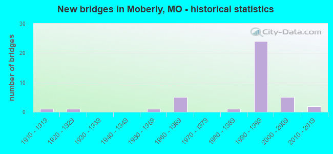
- New bridges - historical statistics
- 11910-1919
- 11920-1929
- 11950-1959
- 51960-1969
- 11980-1989
- 241990-1999
- 52000-2009
- 22010-2019
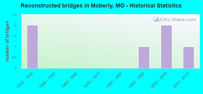
- Reconstructed bridges - Historical Statistics
- 21940-1949
- 01950-1959
- 01960-1969
- 01970-1979
- 01980-1989
- 11990-1999
- 22000-2009
- 12010-2019
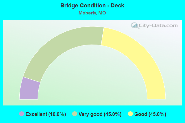
- Bridge Condition - Deck
- 10.0%Excellent
- 45.0%Very good
- 45.0%Good
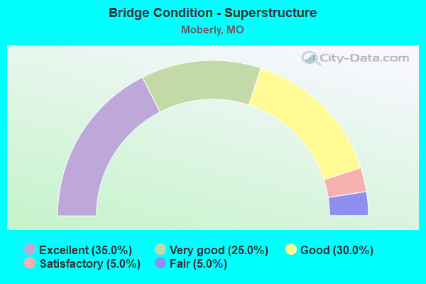
- Bridge Condition - Superstructure
- 35.0%Excellent
- 25.0%Very good
- 30.0%Good
- 5.0%Satisfactory
- 5.0%Fair
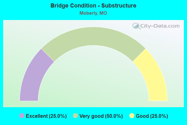
- Bridge Condition - Substructure
- 25.0%Excellent
- 50.0%Very good
- 25.0%Good
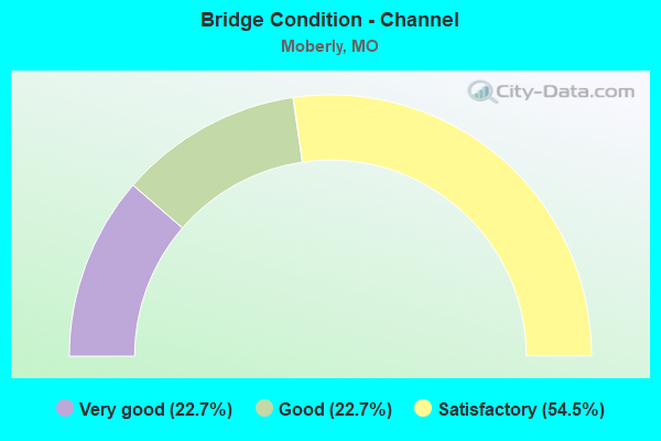
- Bridge Condition - Channel
- 22.7%Very good
- 22.7%Good
- 54.5%Satisfactory
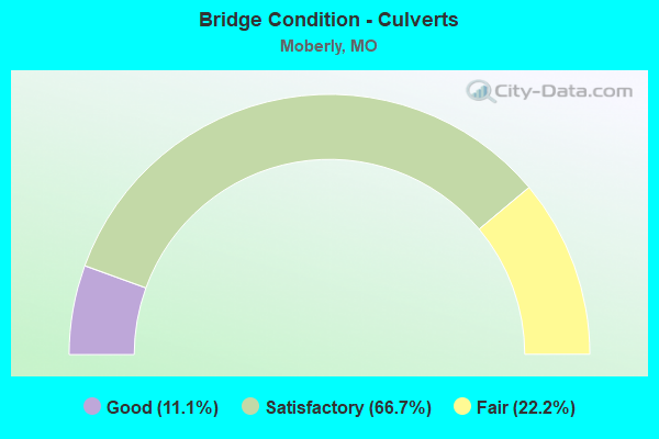
- Bridge Condition - Culverts
- 11.1%Good
- 66.7%Satisfactory
- 22.2%Fair
Find on map >> Show street view
Structure Number: 11764, Location: S 31 T 54 N R 13 W (Lat: 39.431189, Lng: -92.415658), Route carried "on" structure: City street , Year Built: 1998, Status: Open, Structure Length: 11.09m (36.38ft), Average Daily Traffic: 4,751 (year 2021), Truck Traffic: 4%, Average Future Daily Traffic: 5,939 (year 2041), Design Load: HS 20, Features Intersected: US 63, OR 63, Facility Carried by Structure: SINNOCK AVE E
Minimum Vertical Clearance: 30+ m (98+ ft), Kilometerpoint: 0.975, Lanes on structure: 2, Lanes under structure: 10, Owner: State Highway Agency, Approaching Roadway Width: 8.5m (27.9ft), Skew: 2 degrees, Material/Design: Steel, Design/Construction: Stringer/Multi-beam, Number Of Spans In Main Unit: 3, Length of Maximum Span: 45.2m (148.3ft), Curb or Sidewalk Widths: Left: 0.2m (0.7ft), Right: 0.2m (0.7ft), Curb-To-Curb Width: 8.2m (26.9ft), Out-to-Out Width: 9.0m (29.5ft)
Condition: Deck: Good, Superstructure: Excellent, Substructure: Excellent, Operating Rating: 63.0 metric tons, Method Used To Determine Operating Rating: Load Factor (LF), Inventory Rating: 37.8 metric tons, Method Used To Determine Inventory Rating: Load Factor (LF), Structural Evaluation: Superior to present desirable criteria, Deck Geometry: High priority of corrective action, Underclear: High priority of corrective action, Approach Roadway Alignment: Equal to present desirable criteria, Length Of Structure Improvement: 1.20m (3.94ft), Designated Inspection Frequency: Every 24 months, Inspection Date: December 2020, Bridge Improvement Cost: $1,191,000, Roadway Improvement Cost: $119,000, Total Project Cost: $1,787,000 ( Estimate for 2022), Deck Structure Type: Concrete Cast-file-Place, Wearing Surface/Protective System: Wearing Surface: Monolithic Concrete, Deck Protection: Epoxy Coated Reinforcing
Find on map >> Show street view
Structure Number: 11792, Location: S 31 T 54 N R 13 W (Lat: 39.444258, Lng: -92.424386), Route carried "on" structure: US 63, Year Built: 1998, Status: Open, Structure Length: 6.77m (22.21ft), Average Daily Traffic: 7,655 (year 2021), Truck Traffic: 15%, Average Future Daily Traffic: 13,396 (year 2041), Design Load: HS 20+Mod, Features Intersected: US 24
Minimum Vertical Clearance: 30+ m (98+ ft), Kilometerpoint: 408.509, Lanes on structure: 3, Lanes under structure: 2, Base Highway Network: Yes, Owner: State Highway Agency, Approaching Roadway Width: 14.0m (45.9ft), Material/Design: Prestressed concrete continuous, Design/Construction: Stringer/Multi-beam, Number Of Spans In Main Unit: 3, Length of Maximum Span: 25.9m (85.0ft), Curb-To-Curb Width: 14.0m (45.9ft), Out-to-Out Width: 14.8m (48.6ft)
Condition: Deck: Good, Superstructure: Very good, Substructure: Good, Inventory Rating: 54.0 metric tons, Method Used To Determine Inventory Rating: Load Factor (LF), Structural Evaluation: Better than present minimum criteria, Deck Geometry: Meets minimum limits, Underclear: Equal to present minimum criteria, Approach Roadway Alignment: Equal to present desirable criteria, Designated Inspection Frequency: Every 48 months, Inspection Date: December 2020, Deck Structure Type: Concrete Cast-file-Place, Wearing Surface/Protective System: Wearing Surface: Monolithic Concrete, Deck Protection: Internally Sealed
Find on map >> Show street view
Structure Number: 11793, Location: S 25 T 54 N R 14 W (Lat: 39.444125, Lng: -92.424672), Route carried "on" structure: US 63, Year Built: 1998, Status: Open, Structure Length: 6.77m (22.21ft), Average Daily Traffic: 5,279 (year 2021), Truck Traffic: 13%, Average Future Daily Traffic: 9,238 (year 2041), Design Load: HS 20+Mod, Features Intersected: US 24
Minimum Vertical Clearance: 30+ m (98+ ft), Kilometerpoint: 134.992, Lanes on structure: 2, Lanes under structure: 2, Base Highway Network: Yes, Owner: State Highway Agency, Approaching Roadway Width: 11.6m (38.1ft), Material/Design: Prestressed concrete continuous, Design/Construction: Stringer/Multi-beam, Number Of Spans In Main Unit: 3, Length of Maximum Span: 25.9m (85.0ft), Curb-To-Curb Width: 11.6m (38.1ft), Out-to-Out Width: 12.4m (40.7ft)
Condition: Deck: Very good, Superstructure: Very good, Substructure: Good, Inventory Rating: 54.0 metric tons, Method Used To Determine Inventory Rating: Load Factor (LF), Structural Evaluation: Better than present minimum criteria, Deck Geometry: Equal to present minimum criteria, Underclear: Equal to present minimum criteria, Approach Roadway Alignment: Equal to present desirable criteria, Designated Inspection Frequency: Every 48 months, Inspection Date: December 2020, Deck Structure Type: Concrete Cast-file-Place, Wearing Surface/Protective System: Wearing Surface: Monolithic Concrete, Deck Protection: Internally Sealed
Find on map >> Show street view
Structure Number: 118, Location: S 6 T 53 N R 13 W (Lat: 39.420031, Lng: -92.414936), Route carried "on" structure: ServiceState highway 63, Year Built: 1998, Status: Open, Structure Length: 13.29m (43.60ft), Average Daily Traffic: 3,064 (year 2021), Truck Traffic: 6%, Average Future Daily Traffic: 3,830 (year 2041), Design Load: HS 20, Features Intersected: BNSF RR, COON CR
Minimum Vertical Clearance: 30+ m (98+ ft), Kilometerpoint: 2.982, Lanes on structure: 2, Owner: State Highway Agency, Approaching Roadway Width: 12.2m (40.0ft), Skew: 1 degrees, Material/Design: Prestressed concrete continuous, Design/Construction: Stringer/Multi-beam, Number Of Spans In Main Unit: 7, Length of Maximum Span: 21.3m (69.9ft), Curb or Sidewalk Widths: Left: 0.2m (0.7ft), Right: 0.2m (0.7ft), Curb-To-Curb Width: 11.8m (38.7ft), Out-to-Out Width: 12.6m (41.3ft)
Condition: Deck: Very good, Superstructure: Excellent, Substructure: Excellent, Channel: Very good, Operating Rating: 78.3 metric tons, Method Used To Determine Operating Rating: Load Factor (LF), Inventory Rating: 46.8 metric tons, Method Used To Determine Inventory Rating: Load Factor (LF), Structural Evaluation: Superior to present desirable criteria, Deck Geometry: Somewhat better than minimum adequacy, Underclear: Equal to present desirable criteria, Waterway Adequacy: Equal to present desirable criteria, Approach Roadway Alignment: Equal to present desirable criteria, Designated Inspection Frequency: Every 48 months, Inspection Date: December 2020, Deck Structure Type: Concrete Cast-file-Place, Wearing Surface/Protective System: Wearing Surface: Monolithic Concrete, Deck Protection: Epoxy Coated Reinforcing
Find on map >> Show street view
Structure Number: 11837, Location: S 7 T 53 N R 13 W (Lat: 39.408553, Lng: -92.412519), Route carried "on" structure: City street , Year Built: 1999, Status: Open, Structure Length: 9.08m (29.79ft), Average Daily Traffic: 215 (year 2021), Truck Traffic: 8%, Average Future Daily Traffic: 269 (year 2041), Design Load: HS 20, Features Intersected: US 63, Facility Carried by Structure: MCKINSEY ST E
Minimum Vertical Clearance: 30+ m (98+ ft), Kilometerpoint: 2.668, Lanes on structure: 2, Lanes under structure: 4, Owner: State Highway Agency, Approaching Roadway Width: 10.4m (34.1ft), Material/Design: Steel continuous, Design/Construction: Stringer/Multi-beam, Number Of Spans In Main Unit: 2, Length of Maximum Span: 36.9m (121.1ft), Curb-To-Curb Width: 10.0m (32.8ft), Out-to-Out Width: 10.8m (35.4ft)
Condition: Deck: Very good, Superstructure: Excellent, Substructure: Very good, Operating Rating: 57.6 metric tons, Method Used To Determine Operating Rating: Load Factor (LF), Inventory Rating: 34.2 metric tons, Method Used To Determine Inventory Rating: Load Factor (LF), Structural Evaluation: Equal to present desirable criteria, Deck Geometry: Better than present minimum criteria, Underclear: Better than present minimum criteria, Approach Roadway Alignment: Equal to present desirable criteria, Designated Inspection Frequency: Every 24 months, Inspection Date: December 2020, Deck Structure Type: Concrete Cast-file-Place, Wearing Surface/Protective System: Wearing Surface: Monolithic Concrete, Deck Protection: Epoxy Coated Reinforcing
Find on map >> Show street view
Structure Number: 11891, Location: S 19 T 53 N R 13 W (Lat: 39.366236, Lng: -92.406233), Route carried "on" structure: US 63, Year Built: 1960, Year Reconstructed: 2000, Status: Open, Structure Length: 0.76m (2.49ft), Average Daily Traffic: 16,488 (year 2021), Truck Traffic: 13%, Average Future Daily Traffic: 28,854 (year 2041), Design Load: H 20, Features Intersected: COON CR
Minimum Vertical Clearance: 30+ m (98+ ft), Kilometerpoint: 144.078, Lanes on structure: 4, Base Highway Network: Yes, Owner: State Highway Agency, Approaching Roadway Width: 11.6m (38.1ft), Skew: 20 degrees, Material/Design: Concrete continuous, Design/Construction: Culvert, Number Of Spans In Main Unit: 2, Length of Maximum Span: 3.7m (12.1ft)
Condition: Channel: Satisfactory, Culverts: Satisfactory, Operating Rating: 72.0 metric tons, Method Used To Determine Operating Rating: Field evaluation and documented engineering judgment, Inventory Rating: 43.2 metric tons, Method Used To Determine Inventory Rating: Field evaluation and documented engineering judgment, Structural Evaluation: Equal to present minimum criteria, Waterway Adequacy: Equal to present minimum criteria, Approach Roadway Alignment: Equal to present desirable criteria, Designated Inspection Frequency: Every 24 months, Inspection Date: December 2020
Find on map >> Show street view
Structure Number: 11924, Location: S 18 T 53 N R 13 W (Lat: 39.386936, Lng: -92.413397), Route carried "on" structure: US 63, Year Built: 1960, Year Reconstructed: 2000, Status: Open, Structure Length: 0.76m (2.49ft), Average Daily Traffic: 15,713 (year 2021), Truck Traffic: 25%, Average Future Daily Traffic: 27,498 (year 2041), Design Load: H 20, Features Intersected: COON CR
Minimum Vertical Clearance: 30+ m (98+ ft), Kilometerpoint: 141.631, Lanes on structure: 4, Base Highway Network: Yes, Owner: State Highway Agency, Approaching Roadway Width: 11.6m (38.1ft), Skew: 20 degrees, Material/Design: Concrete continuous, Design/Construction: Culvert, Number Of Spans In Main Unit: 2, Length of Maximum Span: 3.7m (12.1ft)
Condition: Channel: Satisfactory, Culverts: Satisfactory, Operating Rating: 72.0 metric tons, Method Used To Determine Operating Rating: Field evaluation and documented engineering judgment, Inventory Rating: 43.2 metric tons, Method Used To Determine Inventory Rating: Field evaluation and documented engineering judgment, Structural Evaluation: Equal to present minimum criteria, Waterway Adequacy: Equal to present minimum criteria, Approach Roadway Alignment: Equal to present desirable criteria, Designated Inspection Frequency: Every 24 months, Inspection Date: December 2020
Find on map >> Show street view
Structure Number: 11929, Location: S 6 T 53 N R 13 W (Lat: 39.420447, Lng: -92.411714), Route carried "on" structure: US 63, Year Built: 1991, Year Reconstructed: 1999, Status: Open, Structure Length: 8.38m (27.49ft), Average Daily Traffic: 7,655 (year 2021), Truck Traffic: 15%, Average Future Daily Traffic: 13,396 (year 2041), Design Load: HS 20+Mod, Features Intersected: NS RR, COON CR
Minimum Vertical Clearance: 30+ m (98+ ft), Kilometerpoint: 405.596, Lanes on structure: 3, Base Highway Network: Yes, Owner: State Highway Agency, Approaching Roadway Width: 14.3m (46.9ft), Material/Design: Prestressed concrete continuous, Design/Construction: Stringer/Multi-beam, Number Of Spans In Main Unit: 4, Length of Maximum Span: 22.4m (73.5ft), Curb-To-Curb Width: 14.4m (47.2ft), Out-to-Out Width: 15.3m (50.2ft)
Condition: Deck: Good, Superstructure: Good, Substructure: Excellent, Channel: Very good, Operating Rating: 70.2 metric tons, Method Used To Determine Operating Rating: Load Factor (LF), Inventory Rating: 28.8 metric tons, Method Used To Determine Inventory Rating: Load Factor (LF), Structural Evaluation: Better than present minimum criteria, Deck Geometry: Meets minimum limits, Underclear: Equal to present desirable criteria, Waterway Adequacy: Equal to present desirable criteria, Approach Roadway Alignment: Equal to present desirable criteria, Designated Inspection Frequency: Every 24 months, Inspection Date: December 2020, Deck Structure Type: Concrete Cast-file-Place, Wearing Surface/Protective System: Wearing Surface: Monolithic Concrete, Deck Protection: Epoxy Coated Reinforcing
Find on map >> Show street view
Structure Number: 11948, Location: S 6 T 53 N R 13 W (Lat: 39.420325, Lng: -92.412056), Route carried "on" structure: US 63, Year Built: 2000, Status: Open, Structure Length: 8.38m (27.49ft), Average Daily Traffic: 7,858 (year 2021), Truck Traffic: 14%, Average Future Daily Traffic: 13,752 (year 2041), Design Load: HS 20+Mod, Features Intersected: NS RR, COON CR
Minimum Vertical Clearance: 30+ m (98+ ft), Kilometerpoint: 137.882, Lanes on structure: 3, Base Highway Network: Yes, Owner: State Highway Agency, Approaching Roadway Width: 14.0m (45.9ft), Material/Design: Prestressed concrete continuous, Design/Construction: Stringer/Multi-beam, Number Of Spans In Main Unit: 4, Length of Maximum Span: 22.4m (73.5ft), Curb-To-Curb Width: 14.0m (45.9ft), Out-to-Out Width: 14.8m (48.6ft)
Condition: Deck: Very good, Superstructure: Excellent, Substructure: Excellent, Channel: Very good, Operating Rating: 90.9 metric tons, Method Used To Determine Operating Rating: Load Factor (LF), Inventory Rating: 45.0 metric tons, Method Used To Determine Inventory Rating: Load Factor (LF), Structural Evaluation: Superior to present desirable criteria, Deck Geometry: Meets minimum limits, Underclear: Equal to present desirable criteria, Waterway Adequacy: Equal to present desirable criteria, Approach Roadway Alignment: Equal to present desirable criteria, Designated Inspection Frequency: Every 48 months, Inspection Date: December 2020, Deck Structure Type: Concrete Cast-file-Place, Wearing Surface/Protective System: Wearing Surface: Monolithic Concrete, Deck Protection: Epoxy Coated Reinforcing
Find on map >> Show street view
Structure Number: 12131, Location: S 35 T 48 N R 33 W (Lat: 38.941611, Lng: -94.538286), Route carried "on" structure: Ramp State highway , Year Built: 2001, Status: Open, Structure Length: 8.38m (27.49ft), Average Daily Traffic: 2,442 (year 2021), Truck Traffic: 5%, Average Future Daily Traffic: 3,297 (year 2041), Design Load: HS 20+Mod, Features Intersected: RP US71S TO IS470E, Facility Carried by Structure: RP RTW TO IS435S S
Minimum Vertical Clearance: 30+ m (98+ ft), Kilometerpoint: 1.452, Lanes on structure: 1, Lanes under structure: 1, Base Highway Network: Yes, Owner: State Highway Agency, Approaching Roadway Width: 9.8m (32.2ft), Skew: 5 degrees, Material/Design: Steel continuous, Design/Construction: Stringer/Multi-beam, Number Of Spans In Main Unit: 3, Length of Maximum Span: 34.7m (113.8ft), Curb-To-Curb Width: 8.5m (27.9ft), Out-to-Out Width: 9.4m (30.8ft)
Condition: Deck: Good, Superstructure: Very good, Substructure: Very good, Inventory Rating: 63.0 metric tons, Method Used To Determine Inventory Rating: Load Factor (LF), Structural Evaluation: Equal to present desirable criteria, Deck Geometry: Superior to present desirable criteria, Underclear: Equal to present desirable criteria, Approach Roadway Alignment: Equal to present desirable criteria, Designated Inspection Frequency: Every 24 months, Inspection Date: October 2021, Deck Structure Type: Concrete Cast-file-Place, Wearing Surface/Protective System: Wearing Surface: Monolithic Concrete, Deck Protection: Epoxy Coated Reinforcing
Find on map >> Show street view
Structure Number: 17338, Location: S 15 T 54 N R 13 W (Lat: 39.472928, Lng: -92.357003), Route carried "on" structure: County highway 149, Year Built: 1993, Status: Open, Structure Length: 3.44m (11.29ft), Average Daily Traffic: 50 (year 2021), Truck Traffic: 10%, Average Future Daily Traffic: 55 (year 2041), Design Load: HS 20, Features Intersected: ELK FK, Facility Carried by Structure: COUNTY RD 1500
Minimum Vertical Clearance: 30+ m (98+ ft), Kilometerpoint: 1.127, Lanes on structure: 2, Owner: County Highway Agency, Approaching Roadway Width: 7.3m (24.0ft), Skew: 3 degrees, Material/Design: Prestressed concrete, Design/Construction: Stringer/Multi-beam, Number Of Spans In Main Unit: 3, Length of Maximum Span: 12.2m (40.0ft), Curb-To-Curb Width: 7.3m (24.0ft), Out-to-Out Width: 8.1m (26.6ft)
Condition: Deck: Very good, Superstructure: Fair, Substructure: Very good, Channel: Good, Operating Rating: 88.2 metric tons, Method Used To Determine Operating Rating: Allowable Stress (AS), Inventory Rating: 52.2 metric tons, Method Used To Determine Inventory Rating: Allowable Stress (AS), Structural Evaluation: Somewhat better than minimum adequacy, Deck Geometry: Equal to present minimum criteria, Waterway Adequacy: Superior to present desirable criteria, Approach Roadway Alignment: Equal to present desirable criteria, Designated Inspection Frequency: Every 24 months, Inspection Date: December 2020, Deck Structure Type: Concrete Precast Panels
Find on map >> Show street view
Structure Number: 17352, Location: S 16 T 54 N R 13 W (Lat: 39.478819, Lng: -92.371444), Route carried "on" structure: County highway 150, Year Built: 1994, Status: Open, Structure Length: 3.11m (10.20ft), Average Daily Traffic: 50 (year 2021), Truck Traffic: 10%, Average Future Daily Traffic: 55 (year 2041), Design Load: HS 20, Features Intersected: ELK FK OF SALT RVR, Facility Carried by Structure: COUNTY RD 1470
Minimum Vertical Clearance: 30+ m (98+ ft), Kilometerpoint: 0.322, Lanes on structure: 2, Owner: County Highway Agency, Approaching Roadway Width: 7.3m (24.0ft), Material/Design: Wood or Timber, Design/Construction: Slab, Number Of Spans In Main Unit: 3, Length of Maximum Span: 11.6m (38.1ft), Curb-To-Curb Width: 7.5m (24.6ft), Out-to-Out Width: 8.1m (26.6ft)
Condition: Deck: Good, Superstructure: Good, Substructure: Good, Channel: Satisfactory, Operating Rating: 47.7 metric tons, Method Used To Determine Operating Rating: Allowable Stress (AS), Inventory Rating: 33.3 metric tons, Method Used To Determine Inventory Rating: Allowable Stress (AS), Structural Evaluation: Better than present minimum criteria, Deck Geometry: Equal to present minimum criteria, Waterway Adequacy: Somewhat better than minimum adequacy, Approach Roadway Alignment: Equal to present minimum criteria, Designated Inspection Frequency: Every 24 months, Inspection Date: December 2020, Deck Structure Type: Wood or Timber, Wearing Surface/Protective System: Wearing Surface: Bituminous
Find on map >> Show street view
Structure Number: 1787, Location: S 22 T 53 N R 14 W (Lat: 39.376703, Lng: -92.463583), Route carried "on" structure: State highway A, Year Built: 1967, Status: Open, Structure Length: 1.01m (3.31ft), Average Daily Traffic: 1,710 (year 2021), Truck Traffic: 14%, Average Future Daily Traffic: 2,138 (year 2041), Design Load: H 20, Features Intersected: SWEET SPRINGS CR
Minimum Vertical Clearance: 30+ m (98+ ft), Kilometerpoint: 2.934, Lanes on structure: 2, Owner: State Highway Agency, Approaching Roadway Width: 9.8m (32.2ft), Skew: 4 degrees, Material/Design: Concrete continuous, Design/Construction: Culvert, Number Of Spans In Main Unit: 2, Length of Maximum Span: 3.4m (11.2ft)
Condition: Channel: Satisfactory, Culverts: Satisfactory, Operating Rating: 72.0 metric tons, Method Used To Determine Operating Rating: Field evaluation and documented engineering judgment, Inventory Rating: 43.2 metric tons, Method Used To Determine Inventory Rating: Field evaluation and documented engineering judgment, Structural Evaluation: Equal to present minimum criteria, Waterway Adequacy: Equal to present minimum criteria, Approach Roadway Alignment: Equal to present desirable criteria, Designated Inspection Frequency: Every 24 months, Inspection Date: December 2020
Find on map >> Show street view
Structure Number: 20365, Location: S 9 T 53 N R 14 W (Lat: 39.394464, Lng: -92.490611), Route carried "on" structure: County highway 257, Year Built: 1990, Status: Open, Structure Length: 2.01m (6.59ft), Average Daily Traffic: 100 (year 2021), Truck Traffic: 10%, Average Future Daily Traffic: 110 (year 2041), Design Load: HS 20, Features Intersected: SWEET SPR CR, Facility Carried by Structure: COUNTY RD 2250
Minimum Vertical Clearance: 30+ m (98+ ft), Kilometerpoint: 1.448, Lanes on structure: 2, Owner: County Highway Agency, Approaching Roadway Width: 6.1m (20.0ft), Material/Design: Prestressed concrete continuous, Design/Construction: Slab, Number Of Spans In Main Unit: 3, Length of Maximum Span: 7.9m (25.9ft), Curb-To-Curb Width: 7.3m (24.0ft), Out-to-Out Width: 8.0m (26.2ft)
Condition: Deck: Good, Superstructure: Good, Substructure: Good, Channel: Satisfactory, Operating Rating: 49.5 metric tons, Method Used To Determine Operating Rating: Allowable Stress (AS), Inventory Rating: 32.4 metric tons, Method Used To Determine Inventory Rating: Allowable Stress (AS), Structural Evaluation: Better than present minimum criteria, Deck Geometry: Equal to present minimum criteria, Waterway Adequacy: Equal to present desirable criteria, Approach Roadway Alignment: Equal to present desirable criteria, Designated Inspection Frequency: Every 24 months, Inspection Date: December 2020, Deck Structure Type: Concrete Cast-file-Place
Find on map >> Show street view
Structure Number: 20579, Location: S 22 T 53 N R 14 W (Lat: 39.370989, Lng: -92.476311), Route carried "on" structure: County highway 265, Year Built: 1994, Status: Open, Structure Length: 0.82m (2.69ft), Average Daily Traffic: 30 (year 2021), Truck Traffic: 10%, Average Future Daily Traffic: 33 (year 2041), Design Load: HS 20, Features Intersected: SWEET SPR CR, Facility Carried by Structure: COUNTY RD 2470
Minimum Vertical Clearance: 30+ m (98+ ft), Kilometerpoint: 1.448, Lanes on structure: 2, Owner: County Highway Agency, Approaching Roadway Width: 7.3m (24.0ft), Skew: 2 degrees, Material/Design: Concrete, Design/Construction: Culvert, Number Of Spans In Main Unit: 2, Length of Maximum Span: 3.7m (12.1ft)
Condition: Channel: Satisfactory, Culverts: Satisfactory, Operating Rating: 68.4 metric tons, Method Used To Determine Operating Rating: Allowable Stress (AS), Inventory Rating: 41.4 metric tons, Method Used To Determine Inventory Rating: Allowable Stress (AS), Structural Evaluation: Equal to present minimum criteria, Waterway Adequacy: Better than present minimum criteria, Approach Roadway Alignment: Equal to present minimum criteria, Designated Inspection Frequency: Every 24 months, Inspection Date: December 2020
Find on map >> Show street view
Structure Number: 20751, Location: S 18 T 53 N R 13 W (Lat: 39.385989, Lng: -92.402972), Route carried "on" structure: County highway 273, Year Built: 1994, Status: Open, Structure Length: 1.68m (5.51ft), Average Daily Traffic: 50 (year 2021), Truck Traffic: 10%, Average Future Daily Traffic: 55 (year 2041), Design Load: HS 20, Features Intersected: BR OF COON CR, Facility Carried by Structure: COUNTY RD 2705
Minimum Vertical Clearance: 30+ m (98+ ft), Kilometerpoint: 0.805, Lanes on structure: 2, Owner: County Highway Agency, Approaching Roadway Width: 7.3m (24.0ft), Material/Design: Steel, Design/Construction: Stringer/Multi-beam, Number Of Spans In Main Unit: 1, Length of Maximum Span: 16.5m (54.1ft), Curb-To-Curb Width: 7.2m (23.6ft), Out-to-Out Width: 7.3m (24.0ft)
Condition: Deck: Good, Superstructure: Good, Substructure: Very good, Channel: Good, Operating Rating: 73.8 metric tons, Method Used To Determine Operating Rating: Allowable Stress (AS), Inventory Rating: 34.2 metric tons, Method Used To Determine Inventory Rating: Allowable Stress (AS), Structural Evaluation: Better than present minimum criteria, Deck Geometry: Somewhat better than minimum adequacy, Waterway Adequacy: Better than present minimum criteria, Approach Roadway Alignment: Equal to present desirable criteria, Designated Inspection Frequency: Every 24 months, Inspection Date: December 2020, Deck Structure Type: Concrete Cast-file-Place
Find on map >> Show street view
Structure Number: 20784, Location: S 17 T 53 N R 13 W (Lat: 39.389522, Lng: -92.393431), Route carried "on" structure: County highway 275, Year Built: 1991, Status: Open, Structure Length: 2.19m (7.19ft), Average Daily Traffic: 50 (year 2021), Truck Traffic: 10%, Average Future Daily Traffic: 55 (year 2041), Features Intersected: COON CR, Facility Carried by Structure: COUNTY RD 2715
Minimum Vertical Clearance: 30+ m (98+ ft), Kilometerpoint: 0.483, Lanes on structure: 2, Owner: County Highway Agency, Approaching Roadway Width: 5.5m (18.0ft), Material/Design: Steel, Design/Construction: Stringer/Multi-beam, Number Of Spans In Main Unit: 1, Length of Maximum Span: 21.0m (68.9ft), Curb-To-Curb Width: 7.2m (23.6ft), Out-to-Out Width: 7.3m (24.0ft)
Condition: Deck: Good, Superstructure: Good, Substructure: Very good, Channel: Good, Operating Rating: 47.7 metric tons, Method Used To Determine Operating Rating: Allowable Stress (AS), Inventory Rating: 28.8 metric tons, Method Used To Determine Inventory Rating: Allowable Stress (AS), Structural Evaluation: Better than present minimum criteria, Deck Geometry: Somewhat better than minimum adequacy, Waterway Adequacy: Equal to present desirable criteria, Approach Roadway Alignment: Equal to present desirable criteria, Designated Inspection Frequency: Every 24 months, Inspection Date: December 2020, Deck Structure Type: Concrete Cast-file-Place
Find on map >> Show street view
Structure Number: 20911, Location: S 5 T 53 N R 13 W (Lat: 39.408383, Lng: -92.376122), Route carried "on" structure: County highway 279, Year Built: 1996, Status: Open, Structure Length: 3.51m (11.52ft), Average Daily Traffic: 75 (year 2021), Truck Traffic: 10%, Average Future Daily Traffic: 83 (year 2041), Design Load: HS 20, Features Intersected: COON CR, Facility Carried by Structure: COUNTY RD 2355
Minimum Vertical Clearance: 30+ m (98+ ft), Kilometerpoint: 3.219, Lanes on structure: 2, Owner: County Highway Agency, Approaching Roadway Width: 7.3m (24.0ft), Skew: 3 degrees, Material/Design: Steel, Design/Construction: Stringer/Multi-beam, Number Of Spans In Main Unit: 3, Length of Maximum Span: 11.4m (37.4ft), Curb-To-Curb Width: 7.3m (24.0ft), Out-to-Out Width: 7.5m (24.6ft)
Condition: Deck: Good, Superstructure: Very good, Substructure: Very good, Channel: Very good, Operating Rating: 89.1 metric tons, Method Used To Determine Operating Rating: Allowable Stress (AS), Inventory Rating: 61.2 metric tons, Method Used To Determine Inventory Rating: Allowable Stress (AS), Structural Evaluation: Equal to present desirable criteria, Deck Geometry: Equal to present minimum criteria, Waterway Adequacy: Equal to present minimum criteria, Approach Roadway Alignment: Better than present minimum criteria, Designated Inspection Frequency: Every 24 months, Inspection Date: December 2020, Deck Structure Type: Concrete Cast-file-Place, Wearing Surface/Protective System: Wearing Surface: Monolithic Concrete
Find on map >> Show street view
Structure Number: 21076, Location: S 33 T 54 N R 13 W (Lat: 39.425978, Lng: -92.372403), Route carried "on" structure: County highway 288, Year Built: 1990, Status: Open, Structure Length: 0.94m (3.08ft), Average Daily Traffic: 30 (year 2021), Truck Traffic: 10%, Average Future Daily Traffic: 33 (year 2041), Design Load: HS 20, Features Intersected: BR OF COON CR, Facility Carried by Structure: COUNTY RD 2350
Minimum Vertical Clearance: 30+ m (98+ ft), Kilometerpoint: 0.805, Lanes on structure: 2, Owner: County Highway Agency, Approaching Roadway Width: 5.5m (18.0ft), Material/Design: Concrete, Design/Construction: Culvert, Number Of Spans In Main Unit: 2, Length of Maximum Span: 4.3m (14.1ft), Curb-To-Curb Width: 7.8m (25.6ft), Out-to-Out Width: 8.4m (27.6ft)
Condition: Channel: Satisfactory, Culverts: Good, Operating Rating: 58.5 metric tons, Method Used To Determine Operating Rating: Allowable Stress (AS), Inventory Rating: 32.4 metric tons, Method Used To Determine Inventory Rating: Allowable Stress (AS), Structural Evaluation: Better than present minimum criteria, Deck Geometry: Equal to present minimum criteria, Waterway Adequacy: Superior to present desirable criteria, Approach Roadway Alignment: Equal to present desirable criteria, Designated Inspection Frequency: Every 24 months, Inspection Date: December 2020
Find on map >> Show street view
Structure Number: 28698, Location: S 15 T 53 N R 14 W (Lat: 39.386661, Lng: -92.468036), Route carried "on" structure: County highway 265, Year Built: 1999, Status: Open, Structure Length: 2.38m (7.81ft), Average Daily Traffic: 30 (year 2021), Truck Traffic: 10%, Average Future Daily Traffic: 33 (year 2041), Features Intersected: SWEET SPR CR, Facility Carried by Structure: COUNTY RD 2285
Minimum Vertical Clearance: 30+ m (98+ ft), Kilometerpoint: 0.322, Lanes on structure: 2, Owner: County Highway Agency, Approaching Roadway Width: 7.3m (24.0ft), Skew: 1 degrees, Material/Design: Steel, Design/Construction: Stringer/Multi-beam, Number Of Spans In Main Unit: 1, Length of Maximum Span: 22.9m (75.1ft), Curb-To-Curb Width: 7.3m (24.0ft), Out-to-Out Width: 7.5m (24.6ft)
Condition: Deck: Very good, Superstructure: Very good, Substructure: Very good, Channel: Very good, Operating Rating: 77.4 metric tons, Method Used To Determine Operating Rating: Load Factor (LF), Inventory Rating: 46.8 metric tons, Method Used To Determine Inventory Rating: Load Factor (LF), Structural Evaluation: Equal to present desirable criteria, Deck Geometry: Equal to present minimum criteria, Waterway Adequacy: Equal to present minimum criteria, Approach Roadway Alignment: Equal to present desirable criteria, Designated Inspection Frequency: Every 24 months, Inspection Date: December 2020, Deck Structure Type: Concrete Cast-file-Place, Wearing Surface/Protective System: Wearing Surface: Monolithic Concrete
Find on map >> Show street view
Structure Number: 30489, Location: S 36 T 54 N R 14 W (Lat: 39.454644, Lng: -92.431853), Route carried "on" structure: Business State highway 63, Year Built: 2004, Status: Open, Structure Length: 10.57m (34.68ft), Average Daily Traffic: 3,264 (year 2021), Truck Traffic: 21%, Average Future Daily Traffic: 4,243 (year 2041), Design Load: HS 25 or greater, Features Intersected: US 63
Minimum Vertical Clearance: 30+ m (98+ ft), Kilometerpoint: 0.061, Lanes on structure: 2, Lanes under structure: 4, Owner: State Highway Agency, Approaching Roadway Width: 12.2m (40.0ft), Material/Design: Steel continuous, Design/Construction: Stringer/Multi-beam, Number Of Spans In Main Unit: 2, Length of Maximum Span: 44.5m (146.0ft), Curb-To-Curb Width: 12.2m (40.0ft), Out-to-Out Width: 13.0m (42.7ft)
Condition: Deck: Very good, Superstructure: Excellent, Substructure: Good, Operating Rating: 83.7 metric tons, Method Used To Determine Operating Rating: Load Factor (LF), Inventory Rating: 49.5 metric tons, Method Used To Determine Inventory Rating: Load Factor (LF), Structural Evaluation: Better than present minimum criteria, Deck Geometry: Equal to present minimum criteria, Underclear: Meets minimum limits, Approach Roadway Alignment: Equal to present desirable criteria, Designated Inspection Frequency: Every 24 months, Inspection Date: December 2020, Deck Structure Type: Concrete Cast-file-Place, Wearing Surface/Protective System: Wearing Surface: Monolithic Concrete, Deck Protection: Internally Sealed
Find on map >> Show street view
Structure Number: 33532, Location: S 8 T 53 N R 13 W (Lat: 39.393494, Lng: -92.388703), Route carried "on" structure: State highway M, Year Built: 2011, Status: Open, Structure Length: 3.54m (11.61ft), Average Daily Traffic: 1,310 (year 2021), Truck Traffic: 14%, Average Future Daily Traffic: 1,637 (year 2041), Design Load: HS 20, Features Intersected: COON CR
Minimum Vertical Clearance: 30+ m (98+ ft), Kilometerpoint: 3.943, Lanes on structure: 2, Owner: State Highway Agency, Approaching Roadway Width: 7.9m (25.9ft), Skew: 3 degrees, Material/Design: Prestressed concrete, Design/Construction: Box Beam or Girders - Single/Spread, Number Of Spans In Main Unit: 3, Length of Maximum Span: 13.7m (44.9ft), Curb-To-Curb Width: 7.9m (25.9ft), Out-to-Out Width: 8.5m (27.9ft)
Condition: Deck: Very good, Superstructure: Excellent, Substructure: Very good, Channel: Good, Operating Rating: 66.6 metric tons, Method Used To Determine Operating Rating: Load Factor (LF), Inventory Rating: 39.6 metric tons, Method Used To Determine Inventory Rating: Load Factor (LF), Structural Evaluation: Equal to present desirable criteria, Deck Geometry: Meets minimum limits, Waterway Adequacy: Superior to present desirable criteria, Approach Roadway Alignment: Equal to present desirable criteria, Designated Inspection Frequency: Every 48 months, Inspection Date: December 2020, Deck Structure Type: Concrete Cast-file-Place, Wearing Surface/Protective System: Wearing Surface: Monolithic Concrete, Deck Protection: Epoxy Coated Reinforcing
Find on map >> Show street view
Structure Number: 34056, Location: S 26 T 54 N R 14 W (Lat: 39.454803, Lng: -92.449339), Route carried "on" structure: County highway 162, Year Built: 2011, Status: Open, Structure Length: 0.91m (2.99ft), Average Daily Traffic: 75 (year 2021), Truck Traffic: 10%, Average Future Daily Traffic: 83 (year 2041), Features Intersected: SUGAR CR, Facility Carried by Structure: COUNTY RD 1330
Minimum Vertical Clearance: 30+ m (98+ ft), Kilometerpoint: 3.862, Lanes on structure: 2, Owner: County Highway Agency, Approaching Roadway Width: 7.3m (24.0ft), Skew: 1 degrees, Material/Design: Concrete, Design/Construction: Channel Beam, Number Of Spans In Main Unit: 1, Length of Maximum Span: 8.5m (27.9ft), Curb-To-Curb Width: 6.8m (22.3ft), Out-to-Out Width: 6.9m (22.6ft)
Condition: Deck: Excellent, Superstructure: Excellent, Substructure: Excellent, Channel: Good, Operating Rating: 61.2 metric tons, Method Used To Determine Operating Rating: Load Factor (LF), Inventory Rating: 36.9 metric tons, Method Used To Determine Inventory Rating: Load Factor (LF), Structural Evaluation: Superior to present desirable criteria, Deck Geometry: Somewhat better than minimum adequacy, Waterway Adequacy: Superior to present desirable criteria, Approach Roadway Alignment: Equal to present desirable criteria, Designated Inspection Frequency: Every 24 months, Inspection Date: December 2020, Deck Structure Type: Concrete Precast Panels
Find on map >> Show street view
Structure Number: 3719, Location: S 25 T 54 N R 14 W (Lat: 39.440800, Lng: -92.435525), Route carried "on" structure: US 24, Year Built: 1988, Status: Open, Structure Length: 6.07m (19.91ft), Average Daily Traffic: 9,977 (year 2021), Truck Traffic: 10%, Average Future Daily Traffic: 12,970 (year 2041), Design Load: HS 20+Mod, Features Intersected: NS RR
Minimum Vertical Clearance: 30+ m (98+ ft), Kilometerpoint: 226.569, Lanes on structure: 4, Base Highway Network: Yes, Owner: State Highway Agency, Approaching Roadway Width: 19.5m (64.0ft), Skew: 1 degrees, Material/Design: Prestressed concrete continuous, Design/Construction: Stringer/Multi-beam, Number Of Spans In Main Unit: 3, Length of Maximum Span: 20.3m (66.6ft), Curb or Sidewalk Widths: Left: 0.2m (0.7ft), Right: 0.2m (0.7ft), Curb-To-Curb Width: 19.1m (62.7ft), Out-to-Out Width: 20.0m (65.6ft)
Condition: Deck: Very good, Superstructure: Good, Substructure: Very good, Operating Rating: 69.3 metric tons, Method Used To Determine Operating Rating: Load Factor (LF), Inventory Rating: 35.1 metric tons, Method Used To Determine Inventory Rating: Load Factor (LF), Structural Evaluation: Better than present minimum criteria, Deck Geometry: Equal to present minimum criteria, Underclear: Better than present minimum criteria, Approach Roadway Alignment: Equal to present minimum criteria, Designated Inspection Frequency: Every 24 months, Inspection Date: December 2020, Deck Structure Type: Concrete Cast-file-Place, Wearing Surface/Protective System: Wearing Surface: Monolithic Concrete
Find on map >> Show street view
Structure Number: 4428, Location: S 20 T 54 N R 13 W (Lat: 39.452558, Lng: -92.393594), Route carried "on" structure: US 24, Year Built: 1918, Year Reconstructed: 1947, Status: Open, Structure Length: 0.77m (2.53ft), Average Daily Traffic: 4,511 (year 2021), Truck Traffic: 22%, Average Future Daily Traffic: 7,894 (year 2041), Design Load: H 15, Features Intersected: ELK FK
Minimum Vertical Clearance: 30+ m (98+ ft), Kilometerpoint: 230.450, Lanes on structure: 2, Base Highway Network: Yes, Owner: State Highway Agency, Approaching Roadway Width: 12.8m (42.0ft), Material/Design: Concrete continuous, Design/Construction: Culvert, Number Of Spans In Main Unit: 2, Length of Maximum Span: 3.7m (12.1ft), Curb-To-Curb Width: 15.1m (49.5ft), Out-to-Out Width: 15.7m (51.5ft)
Condition: Channel: Satisfactory, Culverts: Fair, Operating Rating: 87.3 metric tons, Method Used To Determine Operating Rating: Load Factor (LF), Inventory Rating: 52.2 metric tons, Method Used To Determine Inventory Rating: Load Factor (LF), Structural Evaluation: Somewhat better than minimum adequacy, Deck Geometry: Superior to present desirable criteria, Waterway Adequacy: Equal to present minimum criteria, Approach Roadway Alignment: Equal to present desirable criteria, Designated Inspection Frequency: Every 24 months, Inspection Date: December 2020
Find on map >> Show street view
Structure Number: 5125, Location: S 30 T 54 N R 13 W (Lat: 39.451558, Lng: -92.400200), Route carried "on" structure: US 24, Year Built: 1928, Year Reconstructed: 1947, Status: Open, Structure Length: 0.64m (2.10ft), Average Daily Traffic: 4,511 (year 2021), Truck Traffic: 22%, Average Future Daily Traffic: 7,894 (year 2041), Design Load: H 15, Features Intersected: ELK FK
Minimum Vertical Clearance: 30+ m (98+ ft), Kilometerpoint: 229.895, Lanes on structure: 2, Base Highway Network: Yes, Owner: State Highway Agency, Approaching Roadway Width: 12.8m (42.0ft), Material/Design: Concrete continuous, Design/Construction: Culvert, Number Of Spans In Main Unit: 2, Length of Maximum Span: 3.0m (9.8ft)
Condition: Channel: Satisfactory, Culverts: Fair, Operating Rating: 60.3 metric tons, Method Used To Determine Operating Rating: Load Factor (LF), Inventory Rating: 36.0 metric tons, Method Used To Determine Inventory Rating: Load Factor (LF), Structural Evaluation: Somewhat better than minimum adequacy, Waterway Adequacy: Equal to present minimum criteria, Approach Roadway Alignment: Equal to present desirable criteria, Designated Inspection Frequency: Every 24 months, Inspection Date: December 2020
Find on map >> Show street view
Structure Number: 6851, Location: S 4 T 53 N R 13 W (Lat: 39.418519, Lng: -92.369761), Route carried "on" structure: State highway EE, Year Built: 1956, Year Reconstructed: 2018, Status: Open, Structure Length: 2.83m (9.28ft), Average Daily Traffic: 1,117 (year 2021), Truck Traffic: 24%, Average Future Daily Traffic: 1,396 (year 2041), Design Load: H 10, Features Intersected: COON CR
Minimum Vertical Clearance: 30+ m (98+ ft), Kilometerpoint: 5.681, Lanes on structure: 2, Owner: State Highway Agency, Approaching Roadway Width: 6.4m (21.0ft), Material/Design: Steel, Design/Construction: Stringer/Multi-beam, Number Of Spans In Main Unit: 3, Length of Maximum Span: 11.3m (37.1ft), Curb-To-Curb Width: 6.7m (22.0ft), Out-to-Out Width: 7.5m (24.6ft)
Condition: Deck: Excellent, Superstructure: Satisfactory, Substructure: Very good, Channel: Satisfactory, Operating Rating: 38.7 metric tons, Method Used To Determine Operating Rating: Load Factor (LF), Inventory Rating: 23.4 metric tons, Method Used To Determine Inventory Rating: Load Factor (LF), Structural Evaluation: Equal to present minimum criteria, Deck Geometry: High priority of corrective action, Waterway Adequacy: Equal to present desirable criteria, Approach Roadway Alignment: Equal to present minimum criteria, Designated Inspection Frequency: Every 24 months, Inspection Date: December 2020, Deck Structure Type: Concrete Cast-file-Place, Wearing Surface/Protective System: Wearing Surface: Monolithic Concrete
Find on map >> Show street view
Structure Number: 7326, Location: S 15 T 53 N R 14 W (Lat: 39.383356, Lng: -92.468122), Route carried "on" structure: State highway BB, Year Built: 1960, Status: Open, Structure Length: 1.14m (3.74ft), Average Daily Traffic: 826 (year 2021), Truck Traffic: 7%, Average Future Daily Traffic: 1,033 (year 2041), Design Load: H 15, Features Intersected: SWEET SPRINGS CR B
Minimum Vertical Clearance: 30+ m (98+ ft), Kilometerpoint: 15.854, Lanes on structure: 2, Owner: State Highway Agency, Approaching Roadway Width: 7.3m (24.0ft), Material/Design: Concrete continuous, Design/Construction: Culvert, Number Of Spans In Main Unit: 3, Length of Maximum Span: 3.7m (12.1ft), Curb-To-Curb Width: 12.2m (40.0ft), Out-to-Out Width: 12.8m (42.0ft)
Condition: Channel: Satisfactory, Culverts: Satisfactory, Operating Rating: 66.6 metric tons, Method Used To Determine Operating Rating: Load Factor (LF), Inventory Rating: 39.6 metric tons, Method Used To Determine Inventory Rating: Load Factor (LF), Structural Evaluation: Equal to present minimum criteria, Deck Geometry: Equal to present desirable criteria, Waterway Adequacy: Equal to present minimum criteria, Approach Roadway Alignment: Equal to present minimum criteria, Designated Inspection Frequency: Every 24 months, Inspection Date: December 2020
Find on map >> Show street view
Structure Number: 7862, Location: S 16 T 54 N R 14 W (Lat: 39.469619, Lng: -92.486861), Route carried "on" structure: State highway DD, Year Built: 1962, Status: Open, Structure Length: 0.75m (2.46ft), Average Daily Traffic: 211 (year 2021), Truck Traffic: 7%, Average Future Daily Traffic: 264 (year 2041), Design Load: H 15, Features Intersected: SUGAR CR
Minimum Vertical Clearance: 30+ m (98+ ft), Kilometerpoint: 10.235, Lanes on structure: 2, Owner: State Highway Agency, Approaching Roadway Width: 7.3m (24.0ft), Material/Design: Concrete continuous, Design/Construction: Culvert, Number Of Spans In Main Unit: 2, Length of Maximum Span: 3.7m (12.1ft), Curb-To-Curb Width: 9.8m (32.2ft), Out-to-Out Width: 10.4m (34.1ft)
Condition: Channel: Satisfactory, Culverts: Satisfactory, Operating Rating: 81.9 metric tons, Method Used To Determine Operating Rating: Load Factor (LF), Inventory Rating: 48.6 metric tons, Method Used To Determine Inventory Rating: Load Factor (LF), Structural Evaluation: Equal to present minimum criteria, Deck Geometry: Better than present minimum criteria, Waterway Adequacy: Equal to present minimum criteria, Approach Roadway Alignment: Equal to present minimum criteria, Designated Inspection Frequency: Every 24 months, Inspection Date: December 2020
Find on map >> Show street view
Structure Number: 11764, Location: S 31 T 54 N R 13 W (Lat: 39.431189, Lng: -92.415658), Route carried "under" structure: US 63, Year Built: 1998, Structure Length: 0. m, Average Daily Traffic: 7,858 (year 2021), Truck Traffic: 14%, Features Intersected: US 63, Facility Carried by Structure: SINNOCK AVE E
Minimum Vertical Clearance: 5.23m (17.16ft), Kilometerpoint: 136.651, Lanes on structure: 2, Lanes under structure: 6, Material/Design: Steel, Design/Construction: Stringer/Multi-beam, Length of Maximum Span: 45.2m (148.3ft)
Find on map >> Show street view
Structure Number: 11764, Location: S 31 T 54 N R 13 W (Lat: 39.431189, Lng: -92.415658), Route carried "under" structure: US 63, Year Built: 1998, Structure Length: 0. m, Average Daily Traffic: 7,655 (year 2021), Truck Traffic: 15%, Features Intersected: US 63, Facility Carried by Structure: SINNOCK AVE E
Minimum Vertical Clearance: 5.16m (16.93ft), Kilometerpoint: 406.902, Lanes on structure: 2, Lanes under structure: 2, Material/Design: Steel, Design/Construction: Stringer/Multi-beam, Length of Maximum Span: 45.2m (148.3ft)
Find on map >> Show street view
Structure Number: 11764, Location: S 31 T 54 N R 13 W (Lat: 39.431189, Lng: -92.415658), Route carried "under" structure: ServiceState highway 63, Year Built: 1998, Structure Length: 0. m, Average Daily Traffic: 3,299 (year 2021), Truck Traffic: 5%, Features Intersected: OR 63, Facility Carried by Structure: SINNOCK AVE E
Minimum Vertical Clearance: 5.08m (16.67ft), Kilometerpoint: 1.685, Lanes on structure: 2, Lanes under structure: 2, Material/Design: Steel, Design/Construction: Stringer/Multi-beam, Length of Maximum Span: 45.2m (148.3ft)
Find on map >> Show street view
Structure Number: 11792, Location: S 31 T 54 N R 13 W (Lat: 39.444258, Lng: -92.424386), Route carried "under" structure: US 24, Year Built: 1998, Structure Length: 0. m, Average Daily Traffic: 14,058 (year 2021), Truck Traffic: 8%, Features Intersected: US 24, Facility Carried by Structure: US 63 N
Minimum Vertical Clearance: 5.23m (17.16ft), Kilometerpoint: 227.636, Lanes on structure: 3, Lanes under structure: 2, Material/Design: Prestressed concrete continuous, Design/Construction: Stringer/Multi-beam, Length of Maximum Span: 25.9m (85.0ft)
Find on map >> Show street view
Structure Number: 11793, Location: S 25 T 54 N R 14 W (Lat: 39.444125, Lng: -92.424672), Route carried "under" structure: US 24, Year Built: 1998, Structure Length: 0. m, Average Daily Traffic: 14,696 (year 2021), Truck Traffic: 6%, Features Intersected: US 24, Facility Carried by Structure: US 63 S
Minimum Vertical Clearance: 5.23m (17.16ft), Kilometerpoint: 227.607, Lanes on structure: 2, Lanes under structure: 2, Material/Design: Prestressed concrete continuous, Design/Construction: Stringer/Multi-beam, Length of Maximum Span: 25.9m (85.0ft)
Find on map >> Show street view
Structure Number: 11802, Location: S 6 T 53 N R 13 W (Lat: 39.417044, Lng: -92.412036), Route carried "under" structure: US 63, Year Built: 1999, Structure Length: 0. m, Average Daily Traffic: 7,858 (year 2021), Truck Traffic: 14%, Features Intersected: US 63, Facility Carried by Structure: RT EE E
Minimum Vertical Clearance: 5.13m (16.83ft), Kilometerpoint: 138.296, Lanes on structure: 4, Lanes under structure: 2, Material/Design: Steel continuous, Design/Construction: Stringer/Multi-beam, Length of Maximum Span: 47.0m (154.2ft)
Find on map >> Show street view
Structure Number: 11802, Location: S 6 T 53 N R 13 W (Lat: 39.417044, Lng: -92.412036), Route carried "under" structure: US 63, Year Built: 1999, Structure Length: 0. m, Average Daily Traffic: 7,924 (year 2021), Truck Traffic: 20%, Features Intersected: US 63, Facility Carried by Structure: RT EE E
Minimum Vertical Clearance: 5.08m (16.67ft), Kilometerpoint: 405.267, Lanes on structure: 4, Lanes under structure: 2, Material/Design: Steel continuous, Design/Construction: Stringer/Multi-beam, Length of Maximum Span: 47.0m (154.2ft)
Find on map >> Show street view
Structure Number: 11837, Location: S 7 T 53 N R 13 W (Lat: 39.408553, Lng: -92.412519), Route carried "under" structure: US 63, Year Built: 1999, Structure Length: 0. m, Average Daily Traffic: 7,384 (year 2021), Truck Traffic: 25%, Features Intersected: US 63, Facility Carried by Structure: MCKINSEY ST E
Minimum Vertical Clearance: 5.36m (17.59ft), Kilometerpoint: 139.234, Lanes on structure: 2, Lanes under structure: 2, Material/Design: Steel continuous, Design/Construction: Stringer/Multi-beam, Length of Maximum Span: 36.9m (121.1ft)
Find on map >> Show street view
Structure Number: 11837, Location: S 7 T 53 N R 13 W (Lat: 39.408553, Lng: -92.412519), Route carried "under" structure: US 63, Year Built: 1999, Structure Length: 0. m, Average Daily Traffic: 7,924 (year 2021), Truck Traffic: 20%, Features Intersected: US 63, Facility Carried by Structure: MCKINSEY ST E
Minimum Vertical Clearance: 5.36m (17.59ft), Kilometerpoint: 404.318, Lanes on structure: 2, Lanes under structure: 2, Material/Design: Steel continuous, Design/Construction: Stringer/Multi-beam, Length of Maximum Span: 36.9m (121.1ft)
Find on map >> Show street view
Structure Number: 30489, Location: S 36 T 54 N R 14 W (Lat: 39.454644, Lng: -92.431853), Route carried "under" structure: US 63, Year Built: 2004, Structure Length: 0. m, Average Daily Traffic: 5,563 (year 2021), Truck Traffic: 15%, Features Intersected: US 63
Minimum Vertical Clearance: 5.00m (16.40ft), Kilometerpoint: 133.700, Lanes on structure: 2, Lanes under structure: 2, Material/Design: Steel continuous, Design/Construction: Stringer/Multi-beam, Length of Maximum Span: 44.5m (146.0ft)
Find on map >> Show street view
Structure Number: 30489, Location: S 36 T 54 N R 14 W (Lat: 39.454644, Lng: -92.431853), Route carried "under" structure: US 63, Year Built: 2004, Structure Length: 0. m, Average Daily Traffic: 5,514 (year 2021), Truck Traffic: 15%, Features Intersected: US 63
Minimum Vertical Clearance: 4.93m (16.17ft), Kilometerpoint: 409.867, Lanes on structure: 2, Lanes under structure: 2, Material/Design: Steel continuous, Design/Construction: Stringer/Multi-beam, Length of Maximum Span: 44.5m (146.0ft)