Bridge Statistics for Milltown, New Jersey (NJ)
Condition, Traffic, Stress, Structural Evaluation, Project Costs
- National Bridge Inventory (NBI) Statistics
- 12Number of bridges
- 157ft / 47.8mTotal length
- $11,095,000Total costs
- 410,868Total average daily traffic
- 81,684Total average daily truck traffic
- National Bridge Inventory (NBI) Registered Bridges for Milltown
- No street view available for this location
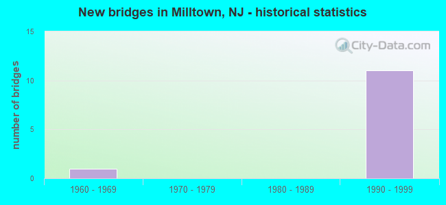
- New bridges - historical statistics
- 11960-1969
- 111990-1999


- Bridge Condition - Deck
- 88.9%Good
- 11.1%Satisfactory

- Bridge Condition - Superstructure
- 33.3%Very good
- 55.6%Good
- 11.1%Satisfactory

- Bridge Condition - Substructure
- 77.8%Good
- 22.2%Satisfactory

- Bridge Condition - Channel
- 33.3%Very good
- 16.7%Good
- 33.3%Satisfactory
- 16.7%Fair
Find on map >> Show street view
Structure Number: 123B133, Location: 0.06 miles E. of Ford Ave (Lat: 40.451319, Lng: -74.437019), Route carried "on" structure: County highway 606, Year Built: 1996, Status: Open, Structure Length: 5.46m (17.91ft), Average Daily Traffic: 14,958 (year 2021), Truck Traffic: 4%, Average Future Daily Traffic: 18,252 (year 2041), Design Load: HS 20+Mod, Features Intersected: MILL POND, Facility Carried by Structure: MAIN STREET
Minimum Vertical Clearance: 30+ m (98+ ft), Kilometerpoint: 5.230, Lanes on structure: 4, Owner: County Highway Agency, Approaching Roadway Width: 13.4m (44.0ft), Material/Design: Prestressed concrete, Design/Construction: Box Beam or Girders - Multiple, Number Of Spans In Main Unit: 3, Length of Maximum Span: 17.4m (57.1ft), Curb or Sidewalk Widths: Left: 1.5m (4.9ft), Right: 1.5m (4.9ft), Curb-To-Curb Width: 13.4m (44.0ft), Out-to-Out Width: 17.1m (56.1ft)
Condition: Deck: Good, Superstructure: Good, Substructure: Good, Channel: Good, Operating Rating: 85.3 metric tons, Method Used To Determine Operating Rating: Load Factor (LF), Inventory Rating: 50.8 metric tons, Method Used To Determine Inventory Rating: Load Factor (LF), Structural Evaluation: Better than present minimum criteria, Deck Geometry: High priority of replacement, Waterway Adequacy: Superior to present desirable criteria, Approach Roadway Alignment: Better than present minimum criteria, Designated Inspection Frequency: Every 24 months, Underwater Inspection Frequency: Every 48 months, Inspection Date: May 2021, Underwater Inspection Date: August 2021, Deck Structure Type: Concrete Cast-file-Place, Wearing Surface/Protective System: Wearing Surface: Monolithic Concrete, Deck Protection: Epoxy Coated Reinforcing
Find on map >> Show street view
Structure Number: 124B029, Location: 0.8 MILE WEST OF NJTPK (Lat: 40.409781, Lng: -74.465000), Route carried "on" structure: City street , Year Built: 1969, Year Reconstructed: 1996, Status: Open, Structure Length: 1.34m (4.40ft), Average Daily Traffic: 1,470 (year 2021), Truck Traffic: 4%, Average Future Daily Traffic: 1,795 (year 2041), Features Intersected: IRELANDS BROOK, Facility Carried by Structure: FRESH PONDS ROAD
Minimum Vertical Clearance: 30+ m (98+ ft), Kilometerpoint: 1.642, Lanes on structure: 2, Owner: County Highway Agency, Approaching Roadway Width: 7.9m (25.9ft), Material/Design: Steel continuous, Design/Construction: Stringer/Multi-beam, Number Of Spans In Main Unit: 2, Length of Maximum Span: 6.4m (21.0ft), Curb or Sidewalk Widths: Left: 0.2m (0.7ft), Right: 1.2m (3.9ft), Curb-To-Curb Width: 7.9m (25.9ft), Out-to-Out Width: 10.0m (32.8ft)
Condition: Deck: Satisfactory, Superstructure: Good, Substructure: Good, Channel: Satisfactory, Inventory Rating: 75.3 metric tons, Method Used To Determine Inventory Rating: Load Factor (LF), Structural Evaluation: Better than present minimum criteria, Deck Geometry: Meets minimum limits, Waterway Adequacy: Somewhat better than minimum adequacy, Approach Roadway Alignment: Equal to present desirable criteria, Designated Inspection Frequency: Every 24 months, Inspection Date: March 2021, Deck Structure Type: Concrete Cast-file-Place, Wearing Surface/Protective System: Wearing Surface: Monolithic Concrete, Deck Protection: Epoxy Coated Reinforcing
Find on map >> Show street view
Structure Number: M08033, Location: 3 MI SOUTH OF INT 9 (Lat: 40.438517, Lng: -74.430250), Route carried "on" structure: Interstate 95, Year Built: 1990, Status: Open, Structure Length: 2.07m (6.79ft), Average Daily Traffic: 45,116 (year 2021), Truck Traffic: 14%, Average Future Daily Traffic: 55,050 (year 2041), Design Load: HS 25 or greater, Features Intersected: BOG BROOK, Facility Carried by Structure: NJ TPK NSO ROADWAY
Minimum Vertical Clearance: 30+ m (98+ ft), Kilometerpoint: 56.327, Lanes on structure: 3, Base Highway Network: Yes, Toll: On toll road, Owner: State Toll Authority, Approaching Roadway Width: 12.5m (41.0ft), Skew: 4 degrees, Material/Design: Prestressed concrete, Design/Construction: Stringer/Multi-beam, Number Of Spans In Main Unit: 1, Length of Maximum Span: 20.1m (65.9ft), Curb-To-Curb Width: 18.0m (59.1ft), Out-to-Out Width: 18.9m (62.0ft)
Condition: Deck: Good, Superstructure: Very good, Substructure: Good, Channel: Satisfactory, Operating Rating: 83.6 metric tons, Method Used To Determine Operating Rating: Load and Resistance Factor Rating (LRFR) rating reported by rating factor(RF) method using HL-93 loadings, Inventory Rating: 64.5 metric tons, Method Used To Determine Inventory Rating: Load and Resistance Factor Rating (LRFR) rating reported by rating factor(RF) method using HL-93 loadings, Structural Evaluation: Better than present minimum criteria, Deck Geometry: Better than present minimum criteria, Waterway Adequacy: Superior to present desirable criteria, Approach Roadway Alignment: Equal to present desirable criteria, Designated Inspection Frequency: Every 24 months, Inspection Date: May 2021, Deck Structure Type: Concrete Cast-file-Place, Wearing Surface/Protective System: Wearing Surface: Latex Concrete, Deck Protection: Epoxy Coated Reinforcing
Find on map >> Show street view
Structure Number: M08037, Location: 3 MI SOUTH OF INT 9 (Lat: 40.438511, Lng: -74.429717), Route carried "on" structure: Interstate 95, Year Built: 1990, Status: Open, Structure Length: 2.07m (6.79ft), Average Daily Traffic: 45,116 (year 2021), Truck Traffic: 31%, Average Future Daily Traffic: 55,050 (year 2041), Design Load: HS 25 or greater, Features Intersected: BOG BROOK, Facility Carried by Structure: NJ TPK SNO ROADWAY
Minimum Vertical Clearance: 30+ m (98+ ft), Kilometerpoint: 56.408, Lanes on structure: 3, Base Highway Network: Yes, Toll: On toll road, Owner: State Toll Authority, Approaching Roadway Width: 17.4m (57.1ft), Skew: 4 degrees, Material/Design: Prestressed concrete, Design/Construction: Stringer/Multi-beam, Number Of Spans In Main Unit: 1, Length of Maximum Span: 18.3m (60.0ft), Curb-To-Curb Width: 17.3m (56.8ft), Out-to-Out Width: 17.9m (58.7ft)
Condition: Deck: Good, Superstructure: Good, Substructure: Good, Channel: Very good, Operating Rating: 87.2 metric tons, Method Used To Determine Operating Rating: Load and Resistance Factor Rating (LRFR) rating reported by rating factor(RF) method using HL-93 loadings, Inventory Rating: 67.4 metric tons, Method Used To Determine Inventory Rating: Load and Resistance Factor Rating (LRFR) rating reported by rating factor(RF) method using HL-93 loadings, Structural Evaluation: Better than present minimum criteria, Deck Geometry: Better than present minimum criteria, Waterway Adequacy: Superior to present desirable criteria, Approach Roadway Alignment: Equal to present desirable criteria, Designated Inspection Frequency: Every 24 months, Inspection Date: May 2021, Deck Structure Type: Concrete Cast-file-Place, Wearing Surface/Protective System: Wearing Surface: Latex Concrete, Deck Protection: Epoxy Coated Reinforcing
Find on map >> Show street view
Structure Number: M08045R, Location: 2.8 MI SOUTH OF INT 9 (Lat: 40.430000, Lng: -74.421667), Route carried "on" structure: County highway 606, Year Built: 1990, Status: Open, Structure Length: 9.81m (32.19ft), Average Daily Traffic: 15,476 (year 2021), Truck Traffic: 4%, Average Future Daily Traffic: 18,881 (year 2041), Design Load: HS 25 or greater, Features Intersected: NJ TPK NSO-NSI SNI SNO, Facility Carried by Structure: MAIN ST
Minimum Vertical Clearance: 30+ m (98+ ft), Kilometerpoint: 3.750, Lanes on structure: 2, Lanes under structure: 12, Owner: State Toll Authority, Approaching Roadway Width: 12.5m (41.0ft), Skew: 3 degrees, Material/Design: Steel continuous, Design/Construction: Stringer/Multi-beam, Number Of Spans In Main Unit: 4, Length of Maximum Span: 24.7m (81.0ft), Curb or Sidewalk Widths: Left: 1.5m (4.9ft), Right: 1.5m (4.9ft), Curb-To-Curb Width: 12.2m (40.0ft), Out-to-Out Width: 15.8m (51.8ft)
Condition: Deck: Good, Superstructure: Good, Substructure: Good, Operating Rating: 79.1 metric tons, Method Used To Determine Operating Rating: Load and Resistance Factor Rating (LRFR) rating reported by rating factor(RF) method using HL-93 loadings, Inventory Rating: 60.9 metric tons, Method Used To Determine Inventory Rating: Load and Resistance Factor Rating (LRFR) rating reported by rating factor(RF) method using HL-93 loadings, Structural Evaluation: Better than present minimum criteria, Deck Geometry: Somewhat better than minimum adequacy, Underclear: Meets minimum limits, Approach Roadway Alignment: Equal to present desirable criteria, Designated Inspection Frequency: Every 24 months, Inspection Date: April 2021, Deck Structure Type: Concrete Cast-file-Place, Wearing Surface/Protective System: Wearing Surface: Latex Concrete, Deck Protection: Epoxy Coated Reinforcing
Find on map >> Show street view
Structure Number: M08076N, Location: 2.5 MI SOUTH OF INT 9 (Lat: 40.443722, Lng: -74.426128), Route carried "on" structure: Interstate 95, Year Built: 1990, Status: Open, Structure Length: 1.22m (4.00ft), Average Daily Traffic: 45,116 (year 2021), Truck Traffic: 19%, Average Future Daily Traffic: 55,050 (year 2041), Design Load: HS 25 or greater, Features Intersected: WESTONS MILL POND, Facility Carried by Structure: NJ TPK SNO ROADWAY
Minimum Vertical Clearance: 30+ m (98+ ft), Kilometerpoint: 56.922, Lanes on structure: 3, Base Highway Network: Yes, Toll: On toll road, Owner: State Toll Authority, Approaching Roadway Width: 14.9m (48.9ft), Material/Design: Prestressed concrete, Design/Construction: Stringer/Multi-beam, Number Of Spans In Main Unit: 1, Length of Maximum Span: 10.7m (35.1ft), Curb-To-Curb Width: 17.3m (56.8ft), Out-to-Out Width: 18.2m (59.7ft)
Condition: Deck: Good, Superstructure: Very good, Substructure: Good, Channel: Very good, Operating Rating: 46.0 metric tons, Method Used To Determine Operating Rating: Load and Resistance Factor Rating (LRFR) rating reported by rating factor(RF) method using HL-93 loadings, Inventory Rating: 27.9 metric tons, Method Used To Determine Inventory Rating: Load and Resistance Factor Rating (LRFR) rating reported by rating factor(RF) method using HL-93 loadings, Structural Evaluation: Better than present minimum criteria, Deck Geometry: Better than present minimum criteria, Waterway Adequacy: Equal to present desirable criteria, Approach Roadway Alignment: Equal to present desirable criteria, Designated Inspection Frequency: Every 24 months, Inspection Date: April 2021, Deck Structure Type: Concrete Cast-file-Place, Wearing Surface/Protective System: Wearing Surface: Latex Concrete, Deck Protection: Epoxy Coated Reinforcing
Find on map >> Show street view
Structure Number: M08076S, Location: 2.5 MI SOUTH OF INT 9 (Lat: 40.433333, Lng: -74.420000), Route carried "on" structure: Interstate 95, Year Built: 1990, Status: Open, Structure Length: 1.13m (3.71ft), Average Daily Traffic: 45,116 (year 2021), Truck Traffic: 14%, Average Future Daily Traffic: 55,050 (year 2041), Design Load: HS 25 or greater, Features Intersected: WESTONS MILL POND, Facility Carried by Structure: NJ TPK NSO ROADWAY
Minimum Vertical Clearance: 30+ m (98+ ft), Kilometerpoint: 56.922, Lanes on structure: 3, Base Highway Network: Yes, Toll: On toll road, Owner: State Toll Authority, Approaching Roadway Width: 18.6m (61.0ft), Material/Design: Prestressed concrete, Design/Construction: Stringer/Multi-beam, Number Of Spans In Main Unit: 1, Length of Maximum Span: 10.7m (35.1ft), Curb-To-Curb Width: 18.3m (60.0ft), Out-to-Out Width: 18.6m (61.0ft)
Condition: Deck: Good, Superstructure: Very good, Substructure: Good, Channel: Fair, Operating Rating: 46.0 metric tons, Method Used To Determine Operating Rating: Load and Resistance Factor Rating (LRFR) rating reported by rating factor(RF) method using HL-93 loadings, Inventory Rating: 27.9 metric tons, Method Used To Determine Inventory Rating: Load and Resistance Factor Rating (LRFR) rating reported by rating factor(RF) method using HL-93 loadings, Structural Evaluation: Better than present minimum criteria, Deck Geometry: Better than present minimum criteria, Waterway Adequacy: Equal to present desirable criteria, Approach Roadway Alignment: Equal to present desirable criteria, Designated Inspection Frequency: Every 24 months, Inspection Date: May 2021, Deck Structure Type: Concrete Cast-file-Place, Wearing Surface/Protective System: Wearing Surface: Latex Concrete, Deck Protection: Epoxy Coated Reinforcing
Find on map >> Show street view
Structure Number: M08097, Location: 2.3 MI SOUTH OF INT 9 (Lat: 40.446533, Lng: -74.424453), Route carried "on" structure: Ramp Interstate 95, Year Built: 1990, Status: Open, Structure Length: 8.72m (28.61ft), Average Daily Traffic: 240 (year 2021), Truck Traffic: 4%, Average Future Daily Traffic: 293 (year 2041), Design Load: HS 25 or greater, Features Intersected: NJ TPK NSO-NSI-SNI-SNI*, Facility Carried by Structure: MILE 81 U-TURN RP
Minimum Vertical Clearance: 30+ m (98+ ft), Kilometerpoint: 92.232, Lanes on structure: 2, Lanes under structure: 10, Toll: On toll road, Owner: State Toll Authority, Approaching Roadway Width: 8.5m (27.9ft), Material/Design: Steel continuous, Design/Construction: Stringer/Multi-beam, Number Of Spans In Main Unit: 5, Length of Maximum Span: 19.8m (65.0ft), Curb-To-Curb Width: 8.1m (26.6ft), Out-to-Out Width: 8.9m (29.2ft)
Condition: Deck: Good, Superstructure: Good, Substructure: Satisfactory, Operating Rating: 63.8 metric tons, Method Used To Determine Operating Rating: Load and Resistance Factor Rating (LRFR) rating reported by rating factor(RF) method using HL-93 loadings, Inventory Rating: 49.2 metric tons, Method Used To Determine Inventory Rating: Load and Resistance Factor Rating (LRFR) rating reported by rating factor(RF) method using HL-93 loadings, Structural Evaluation: Equal to present minimum criteria, Deck Geometry: High priority of corrective action, Underclear: Meets minimum limits, Approach Roadway Alignment: Equal to present desirable criteria, Length Of Structure Improvement: 8.72m (28.61ft), Designated Inspection Frequency: Every 24 months, Inspection Date: May 2021, Bridge Improvement Cost: $4,004,000, Roadway Improvement Cost: $600,000, Total Project Cost: $5,295,000 ( Estimate for 2019), Deck Structure Type: Concrete Cast-file-Place, Wearing Surface/Protective System: Wearing Surface: Latex Concrete, Deck Protection: Epoxy Coated Reinforcing
Find on map >> Show street view
Structure Number: M08109R, Location: 2.2 MI SOUTH OF INT 9 (Lat: 40.447967, Lng: -74.424164), Route carried "on" structure: County highway 617, Year Built: 1990, Status: Open, Structure Length: 15.94m (52.30ft), Average Daily Traffic: 17,745 (year 2021), Truck Traffic: 3%, Average Future Daily Traffic: 21,652 (year 2041), Design Load: HS 25 or greater, Features Intersected: NJ TPK NS0 NSI SNI SNO, Facility Carried by Structure: RYDERS LANE
Minimum Vertical Clearance: 30+ m (98+ ft), Kilometerpoint: 57.454, Lanes on structure: 4, Lanes under structure: 10, Owner: State Toll Authority, Approaching Roadway Width: 16.2m (53.1ft), Skew: 5 degrees, Material/Design: Steel continuous, Design/Construction: Stringer/Multi-beam, Number Of Spans In Main Unit: 4, Length of Maximum Span: 40.8m (133.9ft), Curb or Sidewalk Widths: Left: 0.0m, Right: 1.5m (4.9ft), Curb-To-Curb Width: 14.1m (46.3ft), Out-to-Out Width: 16.5m (54.1ft)
Condition: Deck: Good, Superstructure: Satisfactory, Substructure: Satisfactory, Operating Rating: 56.1 metric tons, Method Used To Determine Operating Rating: Load and Resistance Factor Rating (LRFR) rating reported by rating factor(RF) method using HL-93 loadings, Inventory Rating: 43.4 metric tons, Method Used To Determine Inventory Rating: Load and Resistance Factor Rating (LRFR) rating reported by rating factor(RF) method using HL-93 loadings, Structural Evaluation: Equal to present minimum criteria, Deck Geometry: High priority of replacement, Underclear: High priority of corrective action, Approach Roadway Alignment: Equal to present desirable criteria, Length Of Structure Improvement: 15.94m (52.30ft), Designated Inspection Frequency: Every 24 months, Inspection Date: April 2021, Bridge Improvement Cost: $4,700,000, Roadway Improvement Cost: $850,000, Total Project Cost: $5,800,000 ( Estimate for 2017), Deck Structure Type: Concrete Cast-file-Place, Wearing Surface/Protective System: Wearing Surface: Latex Concrete, Deck Protection: Epoxy Coated Reinforcing
Find on map >> Show street view
Structure Number: M08045R, Location: 2.8 MI SOUTH OF INT 9 (Lat: 40.430000, Lng: -74.421667), Route carried "under" structure: Interstate 95, Year Built: 1990, Structure Length: 0. m, Average Daily Traffic: 90,232 (year 2021), Truck Traffic: 20%, Features Intersected: NJ TPK NSO-NSI SNI SNO, Facility Carried by Structure: MAIN ST
Minimum Vertical Clearance: 5.28m (17.32ft), Kilometerpoint: 56.488, Lanes on structure: 2, Lanes under structure: 12, Toll: On toll road, Material/Design: Steel continuous, Design/Construction: Stringer/Multi-beam, Length of Maximum Span: 24.7m (81.0ft)
Find on map >> Show street view
Structure Number: M08097, Location: 2.3 MI SOUTH OF INT 9 (Lat: 40.446533, Lng: -74.424453), Route carried "under" structure: Interstate 95, Year Built: 1990, Structure Length: 0. m, Average Daily Traffic: 45,116 (year 2021), Truck Traffic: 28%, Features Intersected: NJ TPK NSO-NSI-SNI-SNI*, Facility Carried by Structure: MILE 81 U-TURN RP
Minimum Vertical Clearance: 6.00m (19.69ft), Kilometerpoint: 92.230, Lanes on structure: 2, Lanes under structure: 10, Toll: On toll road, Material/Design: Steel continuous, Design/Construction: Stringer/Multi-beam, Length of Maximum Span: 19.8m (65.0ft)
Find on map >> Show street view
Structure Number: M08109R, Location: 2.2 MI SOUTH OF INT 9 (Lat: 40.447967, Lng: -74.424164), Route carried "under" structure: Interstate 95, Year Built: 1990, Structure Length: 0. m, Average Daily Traffic: 45,167 (year 2021), Truck Traffic: 31%, Features Intersected: NJ TPK NS0 NSI SNI SNO, Facility Carried by Structure: RYDERS LANE
Minimum Vertical Clearance: 4.67m (15.32ft), Kilometerpoint: 57.566, Lanes on structure: 4, Lanes under structure: 10, Toll: On toll road, Material/Design: Steel continuous, Design/Construction: Stringer/Multi-beam, Length of Maximum Span: 40.8m (133.9ft)