Bridge Statistics for Miles City, Montana (MT)
Condition, Traffic, Stress, Structural Evaluation, Project Costs
- National Bridge Inventory (NBI) Statistics
- 28Number of bridges
- 486ft / 148mTotal length
- $1,253,000Total costs
- 98,135Total average daily traffic
- 13,812Total average daily truck traffic
- National Bridge Inventory (NBI) Registered Bridges for Miles City
- No street view available for this location
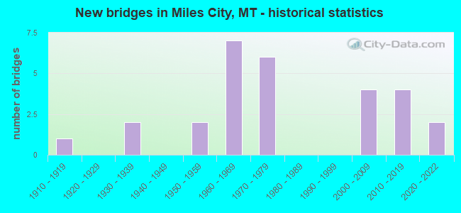
- New bridges - historical statistics
- 11910-1919
- 21930-1939
- 21950-1959
- 71960-1969
- 61970-1979
- 42000-2009
- 42010-2019
- 22020-2022


- Bridge Condition - Deck
- 5.0%Very good
- 25.0%Good
- 55.0%Satisfactory
- 15.0%Fair

- Bridge Condition - Superstructure
- 15.0%Very good
- 35.0%Good
- 25.0%Satisfactory
- 25.0%Fair

- Bridge Condition - Substructure
- 5.0%Very good
- 50.0%Good
- 40.0%Satisfactory
- 5.0%Fair

- Bridge Condition - Channel
- 7.7%Very good
- 46.2%Good
- 38.5%Satisfactory
- 7.7%Fair
Find on map >> Show street view
Structure Number: 202001435, Location: 0.6 m west bonner (Lat: 46.871889, Lng: -113.886781), Route carried "on" structure: Interstate 90, Year Built: 2019, Status: Open, Structure Length: 14.27m (46.82ft), Average Daily Traffic: 15,074 (year 2020), Truck Traffic: 13%, Average Future Daily Traffic: 15,828 (year 2040), Design Load: HL 93, Features Intersected: Black Foot River
Minimum Vertical Clearance: 30+ m (98+ ft), Kilometerpoint: 176.776, Lanes on structure: 2, Base Highway Network: Yes, Owner: State Highway Agency, Approaching Roadway Width: 11.6m (38.1ft), Material/Design: Steel continuous, Design/Construction: Stringer/Multi-beam, Number Of Spans In Main Unit: 3, Length of Maximum Span: 64.0m (210.0ft), Curb-To-Curb Width: 11.6m (38.1ft), Out-to-Out Width: 12.3m (40.4ft)
Condition: Deck: Very good, Superstructure: Very good, Substructure: Very good, Channel: Very good, Operating Rating: 40.8 metric tons, Method Used To Determine Operating Rating: Load and Resistance Factor (LRFR), Inventory Rating: 31.8 metric tons, Method Used To Determine Inventory Rating: Load and Resistance Factor (LRFR), Structural Evaluation: Better than present minimum criteria, Deck Geometry: Equal to present minimum criteria, Waterway Adequacy: Superior to present desirable criteria, Approach Roadway Alignment: Equal to present desirable criteria, Designated Inspection Frequency: Every 24 months, Inspection Date: May 2020, Deck Structure Type: Concrete Cast-file-Place, Wearing Surface/Protective System: Wearing Surface: Monolithic Concrete, Deck Protection: Epoxy Coated Reinforcing
Find on map >> Show street view
Structure Number: 202001986, Location: SE EDGE MILES CITY (Lat: 46.394464, Lng: -105.822608), Route carried "on" structure: Interstate 94, Year Built: 2019, Status: Open, Structure Length: 4.71m (15.45ft), Average Daily Traffic: 5,798 (year 2020), Truck Traffic: 20%, Average Future Daily Traffic: 6,204 (year 2040), Design Load: HL 93, Features Intersected: INT P-23 BROADUS
Minimum Vertical Clearance: 30+ m (98+ ft), Kilometerpoint: 222.256, Lanes on structure: 2, Lanes under structure: 2, Base Highway Network: Yes, Owner: State Highway Agency, Approaching Roadway Width: 11.6m (38.1ft), Skew: 3 degrees, Material/Design: Prestressed concrete, Design/Construction: Stringer/Multi-beam, Number Of Spans In Main Unit: 2, Length of Maximum Span: 23.1m (75.8ft), Curb-To-Curb Width: 12.0m (39.4ft), Out-to-Out Width: 12.8m (42.0ft)
Condition: Deck: Good, Superstructure: Very good, Substructure: Good, Operating Rating: 50.8 metric tons, Method Used To Determine Operating Rating: Load and Resistance Factor (LRFR), Inventory Rating: 25.4 metric tons, Method Used To Determine Inventory Rating: Load and Resistance Factor (LRFR), Structural Evaluation: Equal to present minimum criteria, Deck Geometry: Equal to present minimum criteria, Underclear: Equal to present minimum criteria, Approach Roadway Alignment: Equal to present desirable criteria, Designated Inspection Frequency: Every 24 months, Inspection Date: July 2020, Deck Structure Type: Concrete Cast-file-Place, Wearing Surface/Protective System: Wearing Surface: Monolithic Concrete
Find on map >> Show street view
Structure Number: 202001987, Location: SE EDGE MILES CITY (Lat: 46.394661, Lng: -105.822639), Route carried "on" structure: Interstate 94, Year Built: 2020, Status: Open, Structure Length: 4.71m (15.45ft), Average Daily Traffic: 5,798 (year 2020), Truck Traffic: 20%, Average Future Daily Traffic: 6,204 (year 2040), Design Load: HL 93, Features Intersected: INT P-23 BROADUS
Minimum Vertical Clearance: 30+ m (98+ ft), Kilometerpoint: 222.256, Lanes on structure: 2, Lanes under structure: 2, Base Highway Network: Yes, Owner: State Highway Agency, Approaching Roadway Width: 11.6m (38.1ft), Skew: 3 degrees, Material/Design: Prestressed concrete, Design/Construction: Stringer/Multi-beam, Number Of Spans In Main Unit: 2, Length of Maximum Span: 23.1m (75.8ft), Curb-To-Curb Width: 12.0m (39.4ft), Out-to-Out Width: 12.8m (42.0ft)
Condition: Deck: Good, Superstructure: Very good, Substructure: Good, Operating Rating: 50.8 metric tons, Method Used To Determine Operating Rating: Load and Resistance Factor (LRFR), Inventory Rating: 25.4 metric tons, Method Used To Determine Inventory Rating: Load and Resistance Factor (LRFR), Structural Evaluation: Equal to present minimum criteria, Deck Geometry: Equal to present minimum criteria, Underclear: Equal to present minimum criteria, Approach Roadway Alignment: Equal to present desirable criteria, Designated Inspection Frequency: Every 24 months, Inspection Date: October 2020, Deck Structure Type: Concrete Cast-file-Place, Wearing Surface/Protective System: Wearing Surface: Bituminous
Find on map >> Show street view
Structure Number: I00094001+01781, Location: 3.7M E BILLINGS (Lat: 45.836731, Lng: -108.383578), Route carried "on" structure: Interstate 94, Year Built: 1967, Status: Open, Structure Length: 4.69m (15.39ft), Average Daily Traffic: 9,062 (year 2020), Truck Traffic: 14%, Average Future Daily Traffic: 9,878 (year 2040), Design Load: HS 20, Features Intersected: DICKIE ROAD
Minimum Vertical Clearance: 30+ m (98+ ft), Kilometerpoint: 1.789, Lanes on structure: 2, Base Highway Network: Yes, Owner: State Highway Agency, Approaching Roadway Width: 11.6m (38.1ft), Skew: 3 degrees, Material/Design: Prestressed concrete, Design/Construction: Stringer/Multi-beam, Number Of Spans In Main Unit: 3, Length of Maximum Span: 18.9m (62.0ft), Curb-To-Curb Width: 11.3m (37.1ft), Out-to-Out Width: 12.2m (40.0ft)
Condition: Deck: Good, Superstructure: Good, Substructure: Good, Operating Rating: 47.2 metric tons, Method Used To Determine Operating Rating: Load and Resistance Factor (LRFR), Inventory Rating: 24.5 metric tons, Method Used To Determine Inventory Rating: Load and Resistance Factor (LRFR), Structural Evaluation: Equal to present minimum criteria, Deck Geometry: Somewhat better than minimum adequacy, Approach Roadway Alignment: Equal to present desirable criteria, Designated Inspection Frequency: Every 24 months, Inspection Date: December 2020, Deck Structure Type: Concrete Cast-file-Place, Wearing Surface/Protective System: Wearing Surface: Monolithic Concrete
Find on map >> Show street view
Structure Number: I00094137+04601, Location: 1M S MILES CITY (Lat: 46.384725, Lng: -105.845456), Route carried "on" structure: Interstate 94, Year Built: 1961, Status: Open, Structure Length: 8.96m (29.40ft), Average Daily Traffic: 5,525 (year 2020), Truck Traffic: 21%, Average Future Daily Traffic: 5,912 (year 2040), Design Load: HS 20, Features Intersected: TONGUE RIVER
Minimum Vertical Clearance: 30+ m (98+ ft), Kilometerpoint: 220.192, Lanes on structure: 2, Base Highway Network: Yes, Owner: State Highway Agency, Approaching Roadway Width: 11.6m (38.1ft), Material/Design: Steel continuous, Design/Construction: Stringer/Multi-beam, Number Of Spans In Main Unit: 3, Length of Maximum Span: 34.1m (111.9ft), Curb-To-Curb Width: 8.4m (27.6ft), Out-to-Out Width: 9.7m (31.8ft)
Condition: Deck: Fair, Superstructure: Satisfactory, Substructure: Satisfactory, Channel: Good, Operating Rating: 70.8 metric tons, Method Used To Determine Operating Rating: Load Factor (LF), Inventory Rating: 41.7 metric tons, Method Used To Determine Inventory Rating: Load Factor (LF), Structural Evaluation: Equal to present minimum criteria, Deck Geometry: High priority of corrective action, Waterway Adequacy: Equal to present desirable criteria, Approach Roadway Alignment: Equal to present desirable criteria, Length Of Structure Improvement: 9.80m (32.15ft), Designated Inspection Frequency: Every 24 months, Inspection Date: June 2021, Bridge Improvement Cost: $547,000, Roadway Improvement Cost: $274,000, Total Project Cost: $821,000, Deck Structure Type: Concrete Cast-file-Place, Wearing Surface/Protective System: Wearing Surface: Monolithic Concrete
Find on map >> Show street view
Structure Number: I00094137+04602, Location: 1M S MILES CITY (Lat: 46.384917, Lng: -105.845553), Route carried "on" structure: Interstate 94, Year Built: 1974, Status: Open, Structure Length: 8.96m (29.40ft), Average Daily Traffic: 5,525 (year 2020), Truck Traffic: 21%, Average Future Daily Traffic: 5,912 (year 2040), Design Load: HS 20, Features Intersected: TONGUE RIVER
Minimum Vertical Clearance: 30+ m (98+ ft), Kilometerpoint: 221.055, Lanes on structure: 2, Base Highway Network: Yes, Owner: State Highway Agency, Approaching Roadway Width: 12.5m (41.0ft), Skew: 1 degrees, Material/Design: Steel continuous, Design/Construction: Stringer/Multi-beam, Number Of Spans In Main Unit: 3, Length of Maximum Span: 34.1m (111.9ft), Curb or Sidewalk Widths: Left: 0.1m (0.3ft), Right: 0.1m (0.3ft), Curb-To-Curb Width: 12.6m (41.3ft), Out-to-Out Width: 13.4m (44.0ft)
Condition: Deck: Satisfactory, Superstructure: Good, Substructure: Good, Channel: Good, Operating Rating: 62.6 metric tons, Method Used To Determine Operating Rating: Load Factor (LF), Inventory Rating: 37.2 metric tons, Method Used To Determine Inventory Rating: Load Factor (LF), Structural Evaluation: Better than present minimum criteria, Deck Geometry: Better than present minimum criteria, Waterway Adequacy: Equal to present desirable criteria, Approach Roadway Alignment: Equal to present desirable criteria, Designated Inspection Frequency: Every 24 months, Inspection Date: June 2021, Deck Structure Type: Concrete Cast-file-Place, Wearing Surface/Protective System: Wearing Surface: Monolithic Concrete
Find on map >> Show street view
Structure Number: I00094137+08981, Location: S EDGE MILES CITY (Lat: 46.391311, Lng: -105.829961), Route carried "on" structure: Interstate 94, Year Built: 1961, Status: Open, Structure Length: 4.66m (15.29ft), Average Daily Traffic: 5,525 (year 2020), Truck Traffic: 21%, Average Future Daily Traffic: 5,912 (year 2040), Design Load: HS 20, Features Intersected: SEP CEMETERY RD
Minimum Vertical Clearance: 30+ m (98+ ft), Kilometerpoint: 221.591, Lanes on structure: 2, Lanes under structure: 2, Base Highway Network: Yes, Owner: State Highway Agency, Approaching Roadway Width: 11.6m (38.1ft), Material/Design: Prestressed concrete, Design/Construction: Stringer/Multi-beam, Number Of Spans In Main Unit: 3, Length of Maximum Span: 18.6m (61.0ft), Curb-To-Curb Width: 8.5m (27.9ft), Out-to-Out Width: 9.7m (31.8ft)
Condition: Deck: Satisfactory, Superstructure: Fair, Substructure: Satisfactory, Operating Rating: 48.1 metric tons, Method Used To Determine Operating Rating: Load and Resistance Factor (LRFR), Inventory Rating: 28.1 metric tons, Method Used To Determine Inventory Rating: Load and Resistance Factor (LRFR), Structural Evaluation: Somewhat better than minimum adequacy, Deck Geometry: High priority of replacement, Underclear: Meets minimum limits, Approach Roadway Alignment: Equal to present desirable criteria, Length Of Structure Improvement: 5.70m (18.70ft), Designated Inspection Frequency: Every 24 months, Inspection Date: July 2020, Bridge Improvement Cost: $288,000, Roadway Improvement Cost: $144,000, Total Project Cost: $432,000, Deck Structure Type: Concrete Cast-file-Place, Wearing Surface/Protective System: Wearing Surface: Monolithic Concrete
Find on map >> Show street view
Structure Number: I00094137+08982, Location: S EDGE MILES CITY (Lat: 46.391528, Lng: -105.830011), Route carried "on" structure: Interstate 94, Year Built: 1974, Status: Open, Structure Length: 4.66m (15.29ft), Average Daily Traffic: 5,798 (year 2020), Truck Traffic: 20%, Average Future Daily Traffic: 6,204 (year 2040), Design Load: HS 20, Features Intersected: SEP CEMETERY RD
Minimum Vertical Clearance: 30+ m (98+ ft), Kilometerpoint: 222.458, Lanes on structure: 2, Lanes under structure: 2, Base Highway Network: Yes, Owner: State Highway Agency, Approaching Roadway Width: 12.0m (39.4ft), Skew: 2 degrees, Material/Design: Prestressed concrete, Design/Construction: Stringer/Multi-beam, Number Of Spans In Main Unit: 3, Length of Maximum Span: 21.6m (70.9ft), Curb or Sidewalk Widths: Left: 0.1m (0.3ft), Right: 0.1m (0.3ft), Curb-To-Curb Width: 12.6m (41.3ft), Out-to-Out Width: 13.5m (44.3ft)
Condition: Deck: Satisfactory, Superstructure: Good, Substructure: Good, Operating Rating: 49.0 metric tons, Method Used To Determine Operating Rating: Load and Resistance Factor (LRFR), Inventory Rating: 28.1 metric tons, Method Used To Determine Inventory Rating: Load and Resistance Factor (LRFR), Structural Evaluation: Better than present minimum criteria, Deck Geometry: Better than present minimum criteria, Underclear: Somewhat better than minimum adequacy, Approach Roadway Alignment: Equal to present desirable criteria, Designated Inspection Frequency: Every 24 months, Inspection Date: July 2020, Deck Structure Type: Concrete Cast-file-Place, Wearing Surface/Protective System: Wearing Surface: Monolithic Concrete
Find on map >> Show street view
Structure Number: L09021000+08001, Location: 4M NE MILES CITY (Lat: 46.436072, Lng: -105.780992), Route carried "on" structure: County highway 9021, Year Built: 1938, Status: Posted for load, Structure Length: 0.87m (2.85ft), Average Daily Traffic: 100 (year 2022), Truck Traffic: 3%, Average Future Daily Traffic: 100 (year 2037), Features Intersected: T AND Y CANAL 032, Facility Carried by Structure: KIRCHER CREEK RD
Minimum Vertical Clearance: 30+ m (98+ ft), Kilometerpoint: 1.241, Lanes on structure: 2, Owner: County Highway Agency, Approaching Roadway Width: 5.6m (18.4ft), Skew: 4 degrees, Material/Design: Steel, Design/Construction: Stringer/Multi-beam, Number Of Spans In Main Unit: 1, Length of Maximum Span: 8.5m (27.9ft), Curb or Sidewalk Widths: Left: 0.2m (0.7ft), Right: 0.2m (0.7ft), Curb-To-Curb Width: 5.2m (17.1ft), Out-to-Out Width: 5.5m (18.0ft)
Condition: Deck: Fair, Superstructure: Satisfactory, Substructure: Satisfactory, Channel: Good, Operating Rating: 41.7 metric tons, Method Used To Determine Operating Rating: Load Factor (LF), Inventory Rating: 24.5 metric tons, Method Used To Determine Inventory Rating: Load Factor (LF), Structural Evaluation: Equal to present minimum criteria, Deck Geometry: High priority of corrective action, Waterway Adequacy: Equal to present desirable criteria, Approach Roadway Alignment: Equal to present minimum criteria, Bridge Posting: Required (Relationship of Operating Rating to Maximum Legal Load: 0.1 - 9.9% below), Designated Inspection Frequency: Every 24 months, Inspection Date: Febuary 2022, Deck Structure Type: Wood or Timber
Find on map >> Show street view
Structure Number: L09021000+09001, Location: 4M NE MILES CITY (Lat: 46.437500, Lng: -105.781039), Route carried "on" structure: County highway 9021, Year Built: 1912, Status: Posted for load, Structure Length: 1.23m (4.04ft), Average Daily Traffic: 100 (year 2022), Truck Traffic: 3%, Average Future Daily Traffic: 100 (year 2037), Features Intersected: KIRCHER CREEK 031, Facility Carried by Structure: KIRCHER CREEK RD
Minimum Vertical Clearance: 30+ m (98+ ft), Kilometerpoint: 1.400, Lanes on structure: 1, Owner: County Highway Agency, Approaching Roadway Width: 6.1m (20.0ft), Material/Design: Steel, Design/Construction: Stringer/Multi-beam, Number Of Spans In Main Unit: 1, Length of Maximum Span: 11.6m (38.1ft), Curb-To-Curb Width: 4.8m (15.7ft), Out-to-Out Width: 4.9m (16.1ft)
Condition: Deck: Satisfactory, Superstructure: Fair, Substructure: Fair, Channel: Fair, Operating Rating: 8.2 metric tons, Method Used To Determine Operating Rating: Load and Resistance Factor (LRFR), Inventory Rating: 6.4 metric tons, Method Used To Determine Inventory Rating: Load and Resistance Factor (LRFR), Structural Evaluation: High priority of corrective action, Deck Geometry: Equal to present desirable criteria, Waterway Adequacy: Equal to present desirable criteria, Approach Roadway Alignment: Equal to present minimum criteria, Bridge Posting: Required (Relationship of Operating Rating to Maximum Legal Load: > 39.9% below), Designated Inspection Frequency: Every 24 months, Inspection Date: April 2021, Deck Structure Type: Wood or Timber, Wearing Surface/Protective System: Wearing Surface: Gravel
Find on map >> Show street view
Structure Number: L09049001+02001, Location: 4M NE MILES CITY (Lat: 46.457000, Lng: -105.802028), Route carried "on" structure: County highway 9049, Year Built: 2016, Status: Open, Structure Length: 0.66m (2.17ft), Average Daily Traffic: 327 (year 2020), Truck Traffic: 3%, Average Future Daily Traffic: 343 (year 2040), Design Load: HL 93, Features Intersected: BENSLEY CREEK 030, Facility Carried by Structure: WYTTENHOVE LN
Minimum Vertical Clearance: 30+ m (98+ ft), Kilometerpoint: 1.861, Lanes on structure: 2, Owner: County Highway Agency, Approaching Roadway Width: 6.8m (22.3ft), Skew: 2 degrees, Material/Design: Concrete, Design/Construction: Culvert, Number Of Spans In Main Unit: 1, Length of Maximum Span: 6.1m (20.0ft), Curb-To-Curb Width: 7.5m (24.6ft), Out-to-Out Width: 7.5m (24.6ft)
Condition: Channel: Good, Culverts: Good, Operating Rating: 50.8 metric tons, Method Used To Determine Operating Rating: Load and Resistance Factor (LRFR), Inventory Rating: 39.0 metric tons, Method Used To Determine Inventory Rating: Load and Resistance Factor (LRFR), Structural Evaluation: Better than present minimum criteria, Deck Geometry: Somewhat better than minimum adequacy, Waterway Adequacy: Better than present minimum criteria, Approach Roadway Alignment: Equal to present desirable criteria, Designated Inspection Frequency: Every 24 months, Inspection Date: April 2021, Wearing Surface/Protective System: Wearing Surface: Gravel
Find on map >> Show street view
Structure Number: L09054000+01001, Location: SW EDGE MILES CITY (Lat: 46.398917, Lng: -105.854972), Route carried "on" structure: County highway 9054, Year Built: 2006, Status: Open, Structure Length: 11.38m (37.34ft), Average Daily Traffic: 100 (year 2022), Truck Traffic: 3%, Average Future Daily Traffic: 100 (year 2037), Design Load: HL 93, Features Intersected: TONGUE RIVER 056, Facility Carried by Structure: PACIFIC AVE
Minimum Vertical Clearance: 3.12m (10.24ft), Kilometerpoint: 0.937, Lanes on structure: 2, Owner: County Highway Agency, Approaching Roadway Width: 7.5m (24.6ft), Material/Design: Prestressed concrete, Design/Construction: Stringer/Multi-beam, Number Of Spans In Main Unit: 3, Length of Maximum Span: 38.0m (124.7ft), Curb or Sidewalk Widths: Left: 2.4m (7.9ft), Right: 0.0m, Curb-To-Curb Width: 9.6m (31.5ft), Out-to-Out Width: 12.7m (41.7ft)
Condition: Deck: Satisfactory, Superstructure: Good, Substructure: Good, Channel: Satisfactory, Operating Rating: 77.0 metric tons, Method Used To Determine Operating Rating: Load and Resistance Factor (LRFR), Inventory Rating: 56.5 metric tons, Method Used To Determine Inventory Rating: Load and Resistance Factor (LRFR), Structural Evaluation: Better than present minimum criteria, Deck Geometry: Better than present minimum criteria, Waterway Adequacy: Equal to present desirable criteria, Approach Roadway Alignment: Equal to present desirable criteria, Designated Inspection Frequency: Every 24 months, Underwater Inspection Frequency: Every 60 months, Inspection Date: April 2021, Underwater Inspection Date: October 2020, Deck Structure Type: Concrete Cast-file-Place, Wearing Surface/Protective System: Wearing Surface: Monolithic Concrete, Deck Protection: Epoxy Coated Reinforcing
Find on map >> Show street view
Structure Number: L09227001+00001, Location: 1M S MILES CITY (Lat: 46.379103, Lng: -105.825914), Route carried "on" structure: City street 8006, Year Built: 1978, Status: Open, Structure Length: 1.16m (3.81ft), Average Daily Traffic: 703 (year 2020), Average Future Daily Traffic: 798 (year 2040), Design Load: HS 20, Features Intersected: T AND Y CANAL 065, Facility Carried by Structure: CEMETARY RD
Minimum Vertical Clearance: 30+ m (98+ ft), Kilometerpoint: 3.913, Lanes on structure: 2, Owner: County Highway Agency, Approaching Roadway Width: 9.1m (29.9ft), Skew: 4 degrees, Material/Design: Prestressed concrete, Design/Construction: Channel Beam, Number Of Spans In Main Unit: 1, Length of Maximum Span: 11.0m (36.1ft), Curb-To-Curb Width: 9.8m (32.2ft), Out-to-Out Width: 10.0m (32.8ft)
Condition: Deck: Satisfactory, Superstructure: Good, Substructure: Good, Channel: Good, Operating Rating: 52.6 metric tons, Method Used To Determine Operating Rating: Assigned rating based on Load Factor Design (LFD) reported in metric tons, Inventory Rating: 32.7 metric tons, Method Used To Determine Inventory Rating: Assigned rating based on Load Factor Design (LFD) reported in metric tons, Structural Evaluation: Better than present minimum criteria, Deck Geometry: Equal to present minimum criteria, Waterway Adequacy: Equal to present desirable criteria, Approach Roadway Alignment: Equal to present desirable criteria, Designated Inspection Frequency: Every 24 months, Inspection Date: Febuary 2022, Deck Structure Type: Concrete Precast Panels, Wearing Surface/Protective System: Wearing Surface: Monolithic Concrete
Find on map >> Show street view
Structure Number: L09247000+01001, Location: 3M SE MILES CITY (Lat: 46.398372, Lng: -105.810394), Route carried "on" structure: County highway 9239, Year Built: 2001, Status: Open, Structure Length: 0.75m (2.46ft), Average Daily Traffic: 100 (year 2022), Truck Traffic: 3%, Average Future Daily Traffic: 100 (year 2037), Features Intersected: T AND Y CANAL 074, Facility Carried by Structure: SIGNAL BUTTE RD
Minimum Vertical Clearance: 30+ m (98+ ft), Kilometerpoint: 0.995, Lanes on structure: 2, Owner: County Highway Agency, Approaching Roadway Width: 7.0m (23.0ft), Material/Design: Steel, Design/Construction: Stringer/Multi-beam, Number Of Spans In Main Unit: 1, Length of Maximum Span: 7.0m (23.0ft), Curb-To-Curb Width: 6.7m (22.0ft), Out-to-Out Width: 6.9m (22.6ft)
Condition: Deck: Satisfactory, Superstructure: Satisfactory, Substructure: Satisfactory, Channel: Good, Operating Rating: 51.2 metric tons, Method Used To Determine Operating Rating: Load Factor (LF), Inventory Rating: 30.6 metric tons, Method Used To Determine Inventory Rating: Load Factor (LF), Structural Evaluation: Equal to present minimum criteria, Deck Geometry: Somewhat better than minimum adequacy, Waterway Adequacy: Equal to present desirable criteria, Approach Roadway Alignment: Equal to present desirable criteria, Designated Inspection Frequency: Every 24 months, Inspection Date: Febuary 2022, Deck Structure Type: Corrugated Steel, Wearing Surface/Protective System: Wearing Surface: Gravel
Find on map >> Show street view
Structure Number: P00002000+00001, Location: 3M SW MILES CITY (Lat: 46.373539, Lng: -105.872078), Route carried "on" structure: Business State highway 94, Year Built: 1961, Status: Open, Structure Length: 8.26m (27.10ft), Average Daily Traffic: 1,234 (year 2020), Truck Traffic: 8%, Average Future Daily Traffic: 1,296 (year 2040), Design Load: HS 20, Features Intersected: INT W MILES CITY-I 94
Minimum Vertical Clearance: 30+ m (98+ ft), Kilometerpoint: 0.010, Lanes on structure: 2, Lanes under structure: 5, Base Highway Network: Yes, Owner: State Highway Agency, Approaching Roadway Width: 8.5m (27.9ft), Skew: 3 degrees, Material/Design: Steel, Design/Construction: Stringer/Multi-beam, Number Of Spans In Main Unit: 4, Length of Maximum Span: 23.8m (78.1ft), Curb-To-Curb Width: 8.5m (27.9ft), Out-to-Out Width: 9.7m (31.8ft)
Condition: Deck: Good, Superstructure: Fair, Substructure: Satisfactory, Operating Rating: 41.7 metric tons, Method Used To Determine Operating Rating: Load and Resistance Factor (LRFR), Inventory Rating: 32.7 metric tons, Method Used To Determine Inventory Rating: Load and Resistance Factor (LRFR), Structural Evaluation: Somewhat better than minimum adequacy, Deck Geometry: Somewhat better than minimum adequacy, Underclear: High priority of corrective action, Approach Roadway Alignment: Equal to present minimum criteria, Designated Inspection Frequency: Every 24 months, Inspection Date: June 2021, Deck Structure Type: Concrete Cast-file-Place
Find on map >> Show street view
Structure Number: P00002000+08791, Location: 2M SW MILES CITY (Lat: 46.386150, Lng: -105.870008), Route carried "on" structure: State highway 94, Year Built: 1954, Status: Open, Structure Length: 9.49m (31.14ft), Average Daily Traffic: 1,234 (year 2020), Truck Traffic: 8%, Average Future Daily Traffic: 1,296 (year 2040), Design Load: HS 20, Features Intersected: RR
Minimum Vertical Clearance: 30+ m (98+ ft), Kilometerpoint: 1.425, Lanes on structure: 2, Base Highway Network: Yes, Owner: State Highway Agency, Approaching Roadway Width: 8.5m (27.9ft), Material/Design: Steel, Design/Construction: Stringer/Multi-beam, Number Of Spans In Main Unit: 2, Number Of Approach Spans: 4, Length of Maximum Span: 19.2m (63.0ft), Curb or Sidewalk Widths: Left: 0.1m (0.3ft), Right: 0.1m (0.3ft), Curb-To-Curb Width: 8.5m (27.9ft), Out-to-Out Width: 10.1m (33.1ft)
Condition: Deck: Satisfactory, Superstructure: Fair, Substructure: Satisfactory, Operating Rating: 34.5 metric tons, Method Used To Determine Operating Rating: Load and Resistance Factor (LRFR), Inventory Rating: 27.2 metric tons, Method Used To Determine Inventory Rating: Load and Resistance Factor (LRFR), Structural Evaluation: Somewhat better than minimum adequacy, Deck Geometry: Somewhat better than minimum adequacy, Underclear: Better than present minimum criteria, Approach Roadway Alignment: Equal to present minimum criteria, Designated Inspection Frequency: Every 24 months, Critical Feature Inspection Frequency: Every 24 months, Inspection Date: June 2021, Critical Feature Inspection Date: June 2021, Deck Structure Type: Concrete Cast-file-Place, Wearing Surface/Protective System: Wearing Surface: Bituminous
Find on map >> Show street view
Structure Number: P00002002+02721, Location: SW EDGE MILES CITY (Lat: 46.403556, Lng: -105.858528), Route carried "on" structure: State highway 94, Year Built: 2007, Status: Open, Structure Length: 9.91m (32.51ft), Average Daily Traffic: 2,643 (year 2020), Truck Traffic: 4%, Average Future Daily Traffic: 2,775 (year 2040), Design Load: HL 93, Features Intersected: TONGUE RIVER
Minimum Vertical Clearance: 30+ m (98+ ft), Kilometerpoint: 3.666, Lanes on structure: 2, Owner: State Highway Agency, Approaching Roadway Width: 20.1m (65.9ft), Material/Design: Prestressed concrete, Design/Construction: Stringer/Multi-beam, Number Of Spans In Main Unit: 3, Length of Maximum Span: 36.0m (118.1ft), Curb or Sidewalk Widths: Left: 0.0m, Right: 1.8m (5.9ft), Curb-To-Curb Width: 15.6m (51.2ft), Out-to-Out Width: 18.1m (59.4ft)
Condition: Deck: Fair, Superstructure: Good, Substructure: Good, Channel: Satisfactory, Operating Rating: 59.9 metric tons, Method Used To Determine Operating Rating: Load and Resistance Factor (LRFR), Inventory Rating: 39.0 metric tons, Method Used To Determine Inventory Rating: Load and Resistance Factor (LRFR), Structural Evaluation: Better than present minimum criteria, Deck Geometry: Superior to present desirable criteria, Waterway Adequacy: Equal to present desirable criteria, Approach Roadway Alignment: Equal to present desirable criteria, Designated Inspection Frequency: Every 24 months, Inspection Date: September 2020, Deck Structure Type: Concrete Cast-file-Place, Wearing Surface/Protective System: Wearing Surface: Monolithic Concrete, Deck Protection: Epoxy Coated Reinforcing
Find on map >> Show street view
Structure Number: P00002006+01971, Location: 2M NE MILES CITY (Lat: 46.426178, Lng: -105.786564), Route carried "on" structure: State highway 94, Year Built: 1974, Status: Open, Structure Length: 8.24m (27.03ft), Average Daily Traffic: 1,106 (year 2020), Truck Traffic: 5%, Average Future Daily Traffic: 1,161 (year 2040), Design Load: HL 93, Features Intersected: INT BAKER-I 94
Minimum Vertical Clearance: 30+ m (98+ ft), Kilometerpoint: 10.212, Lanes on structure: 2, Lanes under structure: 4, Base Highway Network: Yes, Owner: State Highway Agency, Approaching Roadway Width: 8.2m (26.9ft), Skew: 2 degrees, Material/Design: Steel continuous, Design/Construction: Stringer/Multi-beam, Number Of Spans In Main Unit: 4, Length of Maximum Span: 27.1m (88.9ft), Curb or Sidewalk Widths: Left: 0.1m (0.3ft), Right: 0.1m (0.3ft), Curb-To-Curb Width: 13.3m (43.6ft), Out-to-Out Width: 14.1m (46.3ft)
Condition: Deck: Satisfactory, Superstructure: Satisfactory, Substructure: Good, Operating Rating: 34.5 metric tons, Method Used To Determine Operating Rating: Load and Resistance Factor (LRFR), Inventory Rating: 26.3 metric tons, Method Used To Determine Inventory Rating: Load and Resistance Factor (LRFR), Structural Evaluation: Equal to present minimum criteria, Deck Geometry: Better than present minimum criteria, Underclear: High priority of corrective action, Approach Roadway Alignment: Equal to present desirable criteria, Designated Inspection Frequency: Every 24 months, Inspection Date: July 2021, Deck Structure Type: Concrete Cast-file-Place, Wearing Surface/Protective System: Wearing Surface: Monolithic Concrete
Find on map >> Show street view
Structure Number: P00018001+00921, Location: MILES CITY (Lat: 46.420806, Lng: -105.859903), Route carried "on" structure: State highway 59, Year Built: 1957, Status: Open, Structure Length: 29.75m (97.60ft), Average Daily Traffic: 2,232 (year 2020), Truck Traffic: 6%, Average Future Daily Traffic: 2,344 (year 2040), Design Load: HS 20, Features Intersected: YELLOWSTONE RIVER
Minimum Vertical Clearance: 30+ m (98+ ft), Kilometerpoint: 1.795, Lanes on structure: 2, Base Highway Network: Yes, Owner: State Highway Agency, Approaching Roadway Width: 8.7m (28.5ft), Material/Design: Steel continuous, Design/Construction: Girder and Floorbeam System, Number Of Spans In Main Unit: 6, Number Of Approach Spans: 1, Length of Maximum Span: 54.9m (180.1ft), Curb or Sidewalk Widths: Left: 0.5m (1.6ft), Right: 0.5m (1.6ft), Curb-To-Curb Width: 8.5m (27.9ft), Out-to-Out Width: 9.7m (31.8ft)
Condition: Deck: Satisfactory, Superstructure: Fair, Substructure: Satisfactory, Channel: Satisfactory, Operating Rating: 43.5 metric tons, Method Used To Determine Operating Rating: Load Factor (LF), Inventory Rating: 26.3 metric tons, Method Used To Determine Inventory Rating: Load Factor (LF), Structural Evaluation: Somewhat better than minimum adequacy, Deck Geometry: Meets minimum limits, Waterway Adequacy: Equal to present desirable criteria, Approach Roadway Alignment: Equal to present desirable criteria, Designated Inspection Frequency: Every 24 months, Critical Feature Inspection Frequency: Every 24 months, Underwater Inspection Frequency: Every 60 months, Inspection Date: June 2021, Critical Feature Inspection Date: June 2021, Underwater Inspection Date: October 2020, Deck Structure Type: Concrete Cast-file-Place, Wearing Surface/Protective System: Wearing Surface: Monolithic Concrete
Find on map >> Show street view
Structure Number: P00018003+09001, Location: 3M NW MILES CITY (Lat: 46.448417, Lng: -105.903278), Route carried "on" structure: State highway 59, Year Built: 1930, Year Reconstructed: 1963, Status: Open, Structure Length: 5.00m (16.40ft), Average Daily Traffic: 446 (year 2020), Truck Traffic: 3%, Average Future Daily Traffic: 468 (year 2040), Design Load: H 15, Features Intersected: SOUTH FORK SUNDAY CREEK
Minimum Vertical Clearance: 30+ m (98+ ft), Kilometerpoint: 6.339, Lanes on structure: 2, Base Highway Network: Yes, Owner: State Highway Agency, Approaching Roadway Width: 8.4m (27.6ft), Material/Design: Concrete, Design/Construction: Tee Beam, Number Of Spans In Main Unit: 4, Length of Maximum Span: 14.1m (46.3ft), Curb-To-Curb Width: 8.5m (27.9ft), Out-to-Out Width: 9.4m (30.8ft)
Condition: Deck: Satisfactory, Superstructure: Satisfactory, Substructure: Satisfactory, Channel: Satisfactory, Operating Rating: 29.0 metric tons, Method Used To Determine Operating Rating: Load and Resistance Factor (LRFR), Inventory Rating: 22.7 metric tons, Method Used To Determine Inventory Rating: Load and Resistance Factor (LRFR), Structural Evaluation: Equal to present minimum criteria, Deck Geometry: Somewhat better than minimum adequacy, Waterway Adequacy: Equal to present desirable criteria, Approach Roadway Alignment: Equal to present desirable criteria, Designated Inspection Frequency: Every 24 months, Inspection Date: April 2021, Wearing Surface/Protective System: Wearing Surface: Bituminous
Find on map >> Show street view
Structure Number: S00489004+02001, Location: 3M N MILES CITY (Lat: 46.472972, Lng: -105.843556), Route carried "on" structure: State highway 489, Year Built: 1961, Status: Open, Structure Length: 6.03m (19.78ft), Average Daily Traffic: 646 (year 2020), Truck Traffic: 3%, Average Future Daily Traffic: 678 (year 2040), Design Load: HS 15, Features Intersected: SUNDAY CREEK
Minimum Vertical Clearance: 30+ m (98+ ft), Kilometerpoint: 6.083, Lanes on structure: 2, Owner: State Highway Agency, Approaching Roadway Width: 8.2m (26.9ft), Material/Design: Prestressed concrete, Design/Construction: Stringer/Multi-beam, Number Of Spans In Main Unit: 3, Length of Maximum Span: 20.4m (66.9ft), Curb-To-Curb Width: 7.3m (24.0ft), Out-to-Out Width: 8.1m (26.6ft)
Condition: Deck: Good, Superstructure: Good, Substructure: Good, Channel: Satisfactory, Operating Rating: 36.2 metric tons, Method Used To Determine Operating Rating: Allowable Stress (AS), Inventory Rating: 24.4 metric tons, Method Used To Determine Inventory Rating: Allowable Stress (AS), Structural Evaluation: Equal to present minimum criteria, Deck Geometry: Meets minimum limits, Waterway Adequacy: Equal to present desirable criteria, Approach Roadway Alignment: Equal to present desirable criteria, Designated Inspection Frequency: Every 24 months, Inspection Date: September 2020, Deck Structure Type: Concrete Cast-file-Place, Wearing Surface/Protective System: Wearing Surface: Bituminous
Find on map >> Show street view
Structure Number: 202001986, Location: SE EDGE MILES CITY (Lat: 46.394464, Lng: -105.822608), Route carried "under" structure: State highway 23, Year Built: 2019, Structure Length: 0. m, Average Daily Traffic: 7,644 (year 2020), Truck Traffic: 5%, Features Intersected: INT P-23 BROADUS, Facility Carried by Structure: I 94
Minimum Vertical Clearance: 4.62m (15.16ft), Kilometerpoint: 2.944, Lanes on structure: 2, Lanes under structure: 2, Material/Design: Prestressed concrete, Design/Construction: Stringer/Multi-beam, Length of Maximum Span: 23.1m (75.8ft)
Find on map >> Show street view
Structure Number: 202001987, Location: SE EDGE MILES CITY (Lat: 46.394661, Lng: -105.822639), Route carried "under" structure: State highway 23, Year Built: 2020, Structure Length: 0. m, Average Daily Traffic: 7,644 (year 2020), Truck Traffic: 5%, Features Intersected: INT P-23 BROADUS, Facility Carried by Structure: I 94
Minimum Vertical Clearance: 5.49m (18.01ft), Kilometerpoint: 2.923, Lanes on structure: 2, Lanes under structure: 2, Material/Design: Prestressed concrete, Design/Construction: Stringer/Multi-beam, Length of Maximum Span: 23.1m (75.8ft)
Find on map >> Show street view
Structure Number: I00094137+08981, Location: S EDGE MILES CITY (Lat: 46.391311, Lng: -105.829961), Route carried "under" structure: ServiceCounty highway 8006, Year Built: 1961, Structure Length: 0. m, Average Daily Traffic: 1,174 (year 2020), Features Intersected: SEP CEMETERY RD, Facility Carried by Structure: I 94
Minimum Vertical Clearance: 4.47m (14.67ft), Kilometerpoint: 2.377, Lanes on structure: 2, Lanes under structure: 2, Material/Design: Prestressed concrete, Design/Construction: Stringer/Multi-beam, Length of Maximum Span: 18.6m (61.0ft)
Find on map >> Show street view
Structure Number: I00094137+08982, Location: S EDGE MILES CITY (Lat: 46.391528, Lng: -105.830011), Route carried "under" structure: ServiceCounty highway 8006, Year Built: 1974, Structure Length: 0. m, Average Daily Traffic: 1,174 (year 2020), Features Intersected: SEP CEMETERY RD, Facility Carried by Structure: I 94
Minimum Vertical Clearance: 4.38m (14.37ft), Kilometerpoint: 2.353, Lanes on structure: 2, Lanes under structure: 2, Material/Design: Prestressed concrete, Design/Construction: Stringer/Multi-beam, Length of Maximum Span: 21.6m (70.9ft)
Find on map >> Show street view
Structure Number: P00002000+00001, Location: 3M SW MILES CITY (Lat: 46.373539, Lng: -105.872078), Route carried "under" structure: Interstate 94, Year Built: 1961, Structure Length: 0. m, Average Daily Traffic: 5,525 (year 2020), Truck Traffic: 21%, Features Intersected: INT W MILES CITY-I 94
Minimum Vertical Clearance: 5.10m (16.73ft), Kilometerpoint: 217.785, Lanes on structure: 2, Lanes under structure: 5, Material/Design: Steel, Design/Construction: Stringer/Multi-beam, Length of Maximum Span: 23.8m (78.1ft)
Find on map >> Show street view
Structure Number: P00002002+02721, Location: SW EDGE MILES CITY (Lat: 46.403556, Lng: -105.858528), Route carried "under" structure: ServiceOther road 9514, Year Built: 2007, Structure Length: 0. m, Average Daily Traffic: 100 (year 2022), Truck Traffic: 3%, Features Intersected: TONGUE RIVER, Facility Carried by Structure: US 94
Minimum Vertical Clearance: 30+ m (98+ ft), Kilometerpoint: 1.565, Lanes on structure: 2, Material/Design: Prestressed concrete, Design/Construction: Stringer/Multi-beam, Length of Maximum Span: 36.0m (118.1ft)
Find on map >> Show street view
Structure Number: P00002006+01971, Location: 2M NE MILES CITY (Lat: 46.426178, Lng: -105.786564), Route carried "under" structure: Interstate 94, Year Built: 1974, Structure Length: 0. m, Average Daily Traffic: 5,798 (year 2020), Truck Traffic: 20%, Features Intersected: INT BAKER-I 94
Minimum Vertical Clearance: 5.16m (16.93ft), Kilometerpoint: 226.857, Lanes on structure: 2, Lanes under structure: 4, Material/Design: Steel continuous, Design/Construction: Stringer/Multi-beam, Length of Maximum Span: 27.1m (88.9ft)