Bridge Statistics for Midlothian, Illinois (IL)
Condition, Traffic, Stress, Structural Evaluation, Project Costs
- National Bridge Inventory (NBI) Statistics
- 12Number of bridges
- 98ft / 30.1mTotal length
- $3,720,000Total costs
- 312,600Total average daily traffic
- 43,050Total average daily truck traffic
- National Bridge Inventory (NBI) Registered Bridges for Midlothian
- No street view available for this location
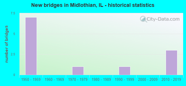
- New bridges - historical statistics
- 71950-1959
- 11970-1979
- 11990-1999
- 32010-2019


- Bridge Condition - Deck
- 60.0%Good
- 40.0%Satisfactory

- Bridge Condition - Superstructure
- 50.0%Very good
- 25.0%Good
- 25.0%Satisfactory

- Bridge Condition - Substructure
- 37.5%Very good
- 25.0%Good
- 37.5%Satisfactory

- Bridge Condition - Channel
- 50.0%Very good
- 12.5%Good
- 25.0%Satisfactory
- 12.5%Fair

- Bridge Condition - Culverts
- 50.0%Good
- 50.0%Fair
Find on map >> Show street view
Structure Number: 160951, Location: 0.5 M E CRAWFORD AV (Lat: 41.625639, Lng: -87.713133), Route carried "on" structure: State highway 83, Year Built: 1954, Status: Open, Structure Length: 1.24m (4.07ft), Average Daily Traffic: 19,800 (year 2021), Truck Traffic: 4%, Average Future Daily Traffic: 18,231 (year 2032), Design Load: HS 20, Features Intersected: MIDLOTHIAN CREEK
Minimum Vertical Clearance: 30+ m (98+ ft), Kilometerpoint: 26.924, Lanes on structure: 4, Base Highway Network: Yes, Owner: State Highway Agency, Approaching Roadway Width: 18.3m (60.0ft), Skew: 4 degrees, Material/Design: Concrete continuous, Design/Construction: Culvert, Number Of Spans In Main Unit: 2, Length of Maximum Span: 6.0m (19.7ft), Curb or Sidewalk Widths: Left: 2.4m (7.9ft), Right: 2.4m (7.9ft), Out-to-Out Width: 23.8m (78.1ft)
Condition: Channel: Fair, Culverts: Fair, Operating Rating: 37.6 metric tons, Method Used To Determine Operating Rating: Load Factor (LF) rating reported by rating factor (RF) method using MS18 loading, Inventory Rating: 22.7 metric tons, Method Used To Determine Inventory Rating: Load Factor (LF) rating reported by rating factor (RF) method using MS18 loading, Structural Evaluation: Somewhat better than minimum adequacy, Waterway Adequacy: Equal to present desirable criteria, Approach Roadway Alignment: Equal to present desirable criteria, Length Of Structure Improvement: 1.83m (6.00ft), Designated Inspection Frequency: Every 24 months, Inspection Date: July 2020, Bridge Improvement Cost: $412,000, Roadway Improvement Cost: $41,000, Total Project Cost: $618,000
Find on map >> Show street view
Structure Number: 163209, Location: 0.25 M S ILL 83 P3 (Lat: 41.622078, Lng: -87.717581), Route carried "on" structure: Other road , Year Built: 1979, Status: Open, Structure Length: 0.91m (2.99ft), Average Daily Traffic: 19,000 (year 2018), Truck Traffic: 6%, Average Future Daily Traffic: 20,085 (year 2032), Design Load: HS 20, Features Intersected: MIDLOTHIAN CR, Facility Carried by Structure: CRAWFORD AVE
Minimum Vertical Clearance: 30+ m (98+ ft), Kilometerpoint: 10.992, Lanes on structure: 4, Base Highway Network: Yes, Owner: County Highway Agency, Approaching Roadway Width: 18.3m (60.0ft), Skew: 34 degrees, Material/Design: Concrete, Design/Construction: Slab, Number Of Spans In Main Unit: 1, Length of Maximum Span: 8.5m (27.9ft), Curb or Sidewalk Widths: Left: 1.5m (4.9ft), Right: 2.4m (7.9ft), Curb-To-Curb Width: 20.1m (65.9ft), Out-to-Out Width: 24.7m (81.0ft)
Condition: Deck: Satisfactory, Superstructure: Satisfactory, Substructure: Satisfactory, Channel: Satisfactory, Operating Rating: 69.0 metric tons, Method Used To Determine Operating Rating: Load Factor (LF) rating reported by rating factor (RF) method using MS18 loading, Inventory Rating: 41.1 metric tons, Method Used To Determine Inventory Rating: Load Factor (LF) rating reported by rating factor (RF) method using MS18 loading, Structural Evaluation: Equal to present minimum criteria, Deck Geometry: Better than present minimum criteria, Waterway Adequacy: Equal to present desirable criteria, Approach Roadway Alignment: Equal to present desirable criteria, Designated Inspection Frequency: Every 24 months, Inspection Date: January 2021, Deck Structure Type: Concrete Cast-file-Place, Wearing Surface/Protective System: Deck Protection: Epoxy Coated Reinforcing
Find on map >> Show street view
Structure Number: 163269, Location: 0.3 M N 147TH ST (Lat: 41.629208, Lng: -87.756875), Route carried "on" structure: Other road , Year Built: 1997, Status: Open, Structure Length: 0.73m (2.40ft), Average Daily Traffic: 6,600 (year 2018), Truck Traffic: 5%, Average Future Daily Traffic: 7,313 (year 2032), Design Load: HS 20, Features Intersected: TRIB "C" CAL SAG, Facility Carried by Structure: CENTRAL AV
Minimum Vertical Clearance: 30+ m (98+ ft), Kilometerpoint: 3.943, Lanes on structure: 2, Owner: County Highway Agency, Approaching Roadway Width: 9.1m (29.9ft), Skew: 3 degrees, Material/Design: Concrete continuous, Design/Construction: Culvert, Number Of Spans In Main Unit: 2, Length of Maximum Span: 3.0m (9.8ft)
Condition: Channel: Very good, Culverts: Good, Operating Rating: 97.2 metric tons, Method Used To Determine Operating Rating: Load Factor (LF) rating reported by rating factor (RF) method using MS18 loading, Inventory Rating: 66.7 metric tons, Method Used To Determine Inventory Rating: Load Factor (LF) rating reported by rating factor (RF) method using MS18 loading, Structural Evaluation: Better than present minimum criteria, Waterway Adequacy: Equal to present desirable criteria, Approach Roadway Alignment: Equal to present desirable criteria, Designated Inspection Frequency: Every 48 months, Inspection Date: June 2019
Find on map >> Show street view
Structure Number: 167645, Location: 0.12 MI N 147TH ST (Lat: 41.627322, Lng: -87.722664), Route carried "on" structure: City street , Year Built: 2011, Status: Open, Structure Length: 0.79m (2.59ft), Average Daily Traffic: 900 (year 2018), Truck Traffic: 12%, Average Future Daily Traffic: 515 (year 2032), Design Load: HS 25 or greater, Features Intersected: NATALIE CREEK, Facility Carried by Structure: KEELER AVENUE
Minimum Vertical Clearance: 30+ m (98+ ft), Kilometerpoint: 0.483, Lanes on structure: 2, Owner: City or Municipal Highway Agency, Approaching Roadway Width: 8.5m (27.9ft), Material/Design: Concrete, Design/Construction: Frame, Number Of Spans In Main Unit: 1, Length of Maximum Span: 7.3m (24.0ft), Curb or Sidewalk Widths: Left: 1.5m (4.9ft), Right: 1.5m (4.9ft), Curb-To-Curb Width: 8.5m (27.9ft), Out-to-Out Width: 19.8m (65.0ft)
Condition: Superstructure: Very good, Substructure: Very good, Channel: Very good, Operating Rating: 54.1 metric tons, Method Used To Determine Operating Rating: Field evaluation and documented engineering judgment, Inventory Rating: 32.4 metric tons, Method Used To Determine Inventory Rating: Field evaluation and documented engineering judgment, Structural Evaluation: Equal to present desirable criteria, Deck Geometry: Somewhat better than minimum adequacy, Waterway Adequacy: Superior to present desirable criteria, Approach Roadway Alignment: Equal to present desirable criteria, Designated Inspection Frequency: Every 48 months, Inspection Date: October 2021, Wearing Surface/Protective System: Wearing Surface: Bituminous, Membrane: Built-up
Find on map >> Show street view
Structure Number: 167646, Location: 0.12 MI N 147TH ST (Lat: 41.627408, Lng: -87.720217), Route carried "on" structure: City street , Year Built: 2011, Status: Open, Structure Length: 0.98m (3.22ft), Average Daily Traffic: 925 (year 2018), Truck Traffic: 10%, Average Future Daily Traffic: 515 (year 2032), Design Load: HS 25 or greater, Features Intersected: NATALIE CREEK, Facility Carried by Structure: KARLOV AVENUE
Minimum Vertical Clearance: 30+ m (98+ ft), Kilometerpoint: 0.563, Lanes on structure: 2, Owner: City or Municipal Highway Agency, Approaching Roadway Width: 8.5m (27.9ft), Material/Design: Concrete, Design/Construction: Frame, Number Of Spans In Main Unit: 1, Length of Maximum Span: 9.1m (29.9ft), Curb or Sidewalk Widths: Left: 1.5m (4.9ft), Right: 1.5m (4.9ft), Curb-To-Curb Width: 8.5m (27.9ft), Out-to-Out Width: 19.8m (65.0ft)
Condition: Superstructure: Very good, Substructure: Very good, Channel: Good, Operating Rating: 54.1 metric tons, Method Used To Determine Operating Rating: Field evaluation and documented engineering judgment, Inventory Rating: 32.4 metric tons, Method Used To Determine Inventory Rating: Field evaluation and documented engineering judgment, Structural Evaluation: Equal to present desirable criteria, Deck Geometry: Somewhat better than minimum adequacy, Waterway Adequacy: Superior to present desirable criteria, Approach Roadway Alignment: Equal to present desirable criteria, Designated Inspection Frequency: Every 48 months, Inspection Date: October 2021, Wearing Surface/Protective System: Wearing Surface: Bituminous, Membrane: Built-up
Find on map >> Show street view
Structure Number: 167647, Location: 0.12 MI N 147TH ST (Lat: 41.627428, Lng: -87.718994), Route carried "on" structure: City street , Year Built: 2011, Status: Open, Structure Length: 0.98m (3.22ft), Average Daily Traffic: 375 (year 2018), Truck Traffic: 13%, Average Future Daily Traffic: 515 (year 2032), Design Load: HS 25 or greater, Features Intersected: NATALIE CREEK, Facility Carried by Structure: KEYSTONE AVENUE
Minimum Vertical Clearance: 30+ m (98+ ft), Kilometerpoint: 0.161, Lanes on structure: 2, Owner: City or Municipal Highway Agency, Approaching Roadway Width: 8.5m (27.9ft), Material/Design: Concrete, Design/Construction: Frame, Number Of Spans In Main Unit: 1, Length of Maximum Span: 9.1m (29.9ft), Curb-To-Curb Width: 8.5m (27.9ft), Out-to-Out Width: 19.8m (65.0ft)
Condition: Superstructure: Very good, Substructure: Very good, Channel: Very good, Operating Rating: 54.1 metric tons, Method Used To Determine Operating Rating: Field evaluation and documented engineering judgment, Inventory Rating: 32.4 metric tons, Method Used To Determine Inventory Rating: Field evaluation and documented engineering judgment, Structural Evaluation: Equal to present desirable criteria, Deck Geometry: Equal to present minimum criteria, Waterway Adequacy: Superior to present desirable criteria, Approach Roadway Alignment: Equal to present desirable criteria, Designated Inspection Frequency: Every 48 months, Inspection Date: October 2021, Wearing Surface/Protective System: Wearing Surface: Bituminous, Membrane: Built-up
Find on map >> Show street view
Structure Number: 169856, Location: 0.8 M NE ILL 83 P3 (Lat: 41.632653, Lng: -87.703683), Route carried "on" structure: Interstate 294, Year Built: 1958, Status: Open, Structure Length: 9.78m (32.09ft), Average Daily Traffic: 61,600 (year 2020), Truck Traffic: 16%, Average Future Daily Traffic: 45,835 (year 2032), Features Intersected: RR & Midlothian Cr.
Minimum Vertical Clearance: 30+ m (98+ ft), Kilometerpoint: 70.407, Lanes on structure: 2, Base Highway Network: Yes, Toll: On toll road, Owner: State Toll Authority, Approaching Roadway Width: 12.2m (40.0ft), Skew: 4 degrees, Material/Design: Steel continuous, Design/Construction: Stringer/Multi-beam, Number Of Spans In Main Unit: 4, Length of Maximum Span: 31.1m (102.0ft), Curb-To-Curb Width: 10.5m (34.4ft), Out-to-Out Width: 18.6m (61.0ft)
Condition: Deck: Good, Superstructure: Good, Substructure: Satisfactory, Channel: Satisfactory, Operating Rating: 60.3 metric tons, Method Used To Determine Operating Rating: Load Factor (LF) rating reported by rating factor (RF) method using MS18 loading, Inventory Rating: 36.0 metric tons, Method Used To Determine Inventory Rating: Load Factor (LF) rating reported by rating factor (RF) method using MS18 loading, Structural Evaluation: Equal to present minimum criteria, Deck Geometry: Meets minimum limits, Underclear: Superior to present desirable criteria, Waterway Adequacy: Superior to present desirable criteria, Approach Roadway Alignment: Equal to present desirable criteria, Length Of Structure Improvement: 9.78m (32.09ft), Designated Inspection Frequency: Every 24 months, Inspection Date: May 2020, Bridge Improvement Cost: $1,034,000, Roadway Improvement Cost: $103,000, Total Project Cost: $1,551,000, Deck Structure Type: Concrete Cast-file-Place, Wearing Surface/Protective System: Wearing Surface: Bituminous, Membrane: Built-up
Find on map >> Show street view
Structure Number: 169857, Location: 0.8 M NE ILL 83 P3 (Lat: 41.632658, Lng: -87.703436), Route carried "on" structure: Interstate 294, Year Built: 1958, Status: Open, Structure Length: 9.78m (32.09ft), Average Daily Traffic: 61,600 (year 2020), Truck Traffic: 16%, Average Future Daily Traffic: 45,835 (year 2032), Features Intersected: RR & Midlothian Cr.
Minimum Vertical Clearance: 30+ m (98+ ft), Kilometerpoint: 70.423, Lanes on structure: 2, Base Highway Network: Yes, Toll: On toll road, Owner: State Toll Authority, Approaching Roadway Width: 12.2m (40.0ft), Skew: 4 degrees, Material/Design: Steel continuous, Design/Construction: Stringer/Multi-beam, Number Of Spans In Main Unit: 4, Length of Maximum Span: 31.1m (102.0ft), Curb-To-Curb Width: 10.5m (34.4ft), Out-to-Out Width: 18.6m (61.0ft)
Condition: Deck: Satisfactory, Superstructure: Good, Substructure: Satisfactory, Channel: Very good, Operating Rating: 60.3 metric tons, Method Used To Determine Operating Rating: Load Factor (LF) rating reported by rating factor (RF) method using MS18 loading, Inventory Rating: 36.0 metric tons, Method Used To Determine Inventory Rating: Load Factor (LF) rating reported by rating factor (RF) method using MS18 loading, Structural Evaluation: Equal to present minimum criteria, Deck Geometry: Meets minimum limits, Underclear: Superior to present desirable criteria, Waterway Adequacy: Superior to present desirable criteria, Approach Roadway Alignment: Equal to present desirable criteria, Length Of Structure Improvement: 9.78m (32.09ft), Designated Inspection Frequency: Every 24 months, Inspection Date: May 2020, Bridge Improvement Cost: $1,034,000, Roadway Improvement Cost: $103,000, Total Project Cost: $1,551,000, Deck Structure Type: Concrete Cast-file-Place, Wearing Surface/Protective System: Wearing Surface: Bituminous, Membrane: Built-up
Find on map >> Show street view
Structure Number: 169858, Location: 0.6 M NE ILL 83 P3 (Lat: 41.632286, Lng: -87.699033), Route carried "on" structure: Interstate 294, Year Built: 1958, Status: Open, Structure Length: 2.44m (8.01ft), Average Daily Traffic: 61,600 (year 2020), Truck Traffic: 16%, Average Future Daily Traffic: 45,835 (year 2032), Features Intersected: KEDZIE AVE
Minimum Vertical Clearance: 30+ m (98+ ft), Kilometerpoint: 70.713, Lanes on structure: 2, Lanes under structure: 2, Base Highway Network: Yes, Toll: On toll road, Owner: State Toll Authority, Approaching Roadway Width: 12.2m (40.0ft), Skew: 2 degrees, Material/Design: Prestressed concrete, Number Of Spans In Main Unit: 1, Length of Maximum Span: 16.8m (55.1ft), Curb-To-Curb Width: 10.5m (34.4ft), Out-to-Out Width: 18.6m (61.0ft)
Condition: Deck: Good, Superstructure: Very good, Substructure: Good, Operating Rating: 63.5 metric tons, Method Used To Determine Operating Rating: Load Factor (LF) rating reported by rating factor (RF) method using MS18 loading, Inventory Rating: 37.9 metric tons, Method Used To Determine Inventory Rating: Load Factor (LF) rating reported by rating factor (RF) method using MS18 loading, Structural Evaluation: Better than present minimum criteria, Deck Geometry: Meets minimum limits, Underclear: Equal to present minimum criteria, Approach Roadway Alignment: Equal to present desirable criteria, Designated Inspection Frequency: Every 24 months, Inspection Date: April 2020, Deck Structure Type: Concrete Cast-file-Place, Wearing Surface/Protective System: Wearing Surface: Bituminous, Membrane: Built-up
Find on map >> Show street view
Structure Number: 169859, Location: 0.6 M NW ILL 83 P3 (Lat: 41.632225, Lng: -87.698800), Route carried "on" structure: Interstate 294, Year Built: 1958, Status: Open, Structure Length: 2.44m (8.01ft), Average Daily Traffic: 61,600 (year 2020), Truck Traffic: 16%, Average Future Daily Traffic: 45,835 (year 2032), Features Intersected: KEDZIE AVE
Minimum Vertical Clearance: 30+ m (98+ ft), Kilometerpoint: 70.729, Lanes on structure: 2, Lanes under structure: 2, Base Highway Network: Yes, Toll: On toll road, Owner: State Toll Authority, Approaching Roadway Width: 12.2m (40.0ft), Skew: 2 degrees, Material/Design: Prestressed concrete, Number Of Spans In Main Unit: 1, Length of Maximum Span: 16.8m (55.1ft), Curb-To-Curb Width: 10.5m (34.4ft), Out-to-Out Width: 18.6m (61.0ft)
Condition: Deck: Good, Superstructure: Satisfactory, Substructure: Good, Operating Rating: 63.5 metric tons, Method Used To Determine Operating Rating: Load Factor (LF) rating reported by rating factor (RF) method using MS18 loading, Inventory Rating: 37.9 metric tons, Method Used To Determine Inventory Rating: Load Factor (LF) rating reported by rating factor (RF) method using MS18 loading, Structural Evaluation: Equal to present minimum criteria, Deck Geometry: Meets minimum limits, Underclear: Equal to present minimum criteria, Approach Roadway Alignment: Equal to present desirable criteria, Designated Inspection Frequency: Every 24 months, Inspection Date: April 2020, Deck Structure Type: Concrete Cast-file-Place, Wearing Surface/Protective System: Wearing Surface: Bituminous, Membrane: Built-up
Find on map >> Show street view
Structure Number: 169858, Location: 0.6 M NE ILL 83 P3 (Lat: 41.632397, Lng: -87.698578), Route carried "under" structure: Other road , Year Built: 1958, Structure Length: 0. m, Average Daily Traffic: 9,300 (year 2018), Truck Traffic: 6%, Features Intersected: KEDZIE AVE, Facility Carried by Structure: I-294 NB
Minimum Vertical Clearance: 4.42m (14.50ft), Kilometerpoint: 40.104, Lanes on structure: 2, Lanes under structure: 2, Toll: On toll road, Material/Design: Prestressed concrete, Length of Maximum Span: 16.8m (55.1ft)
Find on map >> Show street view
Structure Number: 169859, Location: 0.6 M NW ILL 83 P3 (Lat: 41.632097, Lng: -87.698567), Route carried "under" structure: Other road , Year Built: 1958, Structure Length: 0. m, Average Daily Traffic: 9,300 (year 2018), Truck Traffic: 6%, Features Intersected: KEDZIE AVE, Facility Carried by Structure: I-294 SB
Minimum Vertical Clearance: 4.42m (14.50ft), Kilometerpoint: 40.136, Lanes on structure: 2, Lanes under structure: 2, Toll: On toll road, Material/Design: Prestressed concrete, Length of Maximum Span: 16.8m (55.1ft)