Bridge Statistics for Middlesex, New Jersey (NJ)
Condition, Traffic, Stress, Structural Evaluation, Project Costs
- National Bridge Inventory (NBI) Statistics
- 20Number of bridges
- 138ft / 42.1mTotal length
- $13,740,000Total costs
- 405,763Total average daily traffic
- 28,076Total average daily truck traffic
- National Bridge Inventory (NBI) Registered Bridges for Middlesex
- No street view available for this location
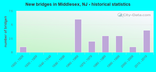
- New bridges - historical statistics
- 11920-1929
- 61960-1969
- 21970-1979
- 31980-1989
- 31990-1999
- 12000-2009
- 42010-2019

- Reconstructed bridges - Historical Statistics
- 11990-1999
- 22000-2009
- 12010-2019


- Bridge Condition - Deck
- 16.7%Very good
- 66.7%Good
- 16.7%Satisfactory

- Bridge Condition - Superstructure
- 38.5%Very good
- 46.2%Good
- 15.4%Satisfactory

- Bridge Condition - Substructure
- 23.1%Very good
- 61.5%Good
- 15.4%Satisfactory

- Bridge Condition - Channel
- 43.8%Good
- 56.3%Satisfactory

- Bridge Condition - Culverts
- 40.0%Good
- 60.0%Satisfactory
Find on map >> Show street view
Structure Number: 122B146, Location: 0.13 miles E of Grant Ave (Lat: 40.580800, Lng: -74.477100), Route carried "on" structure: City street , Year Built: 2012, Status: Open, Structure Length: 2.65m (8.69ft), Average Daily Traffic: 9,895 (year 2021), Truck Traffic: 3%, Average Future Daily Traffic: 12,074 (year 2041), Design Load: HL 93, Features Intersected: BOUND BROOK, Facility Carried by Structure: SOUTH AVENUE
Minimum Vertical Clearance: 30+ m (98+ ft), Kilometerpoint: 3.026, Lanes on structure: 2, Owner: County Highway Agency, Approaching Roadway Width: 11.0m (36.1ft), Skew: 4 degrees, Material/Design: Steel, Design/Construction: Stringer/Multi-beam, Number Of Spans In Main Unit: 1, Length of Maximum Span: 24.4m (80.1ft), Curb or Sidewalk Widths: Left: 1.5m (4.9ft), Right: 1.5m (4.9ft), Curb-To-Curb Width: 11.0m (36.1ft), Out-to-Out Width: 14.7m (48.2ft)
Condition: Deck: Good, Superstructure: Very good, Substructure: Very good, Channel: Satisfactory, Operating Rating: 64.2 metric tons, Method Used To Determine Operating Rating: Load and Resistance Factor Rating (LRFR) rating reported by rating factor(RF) method using HL-93 loadings, Inventory Rating: 50.2 metric tons, Method Used To Determine Inventory Rating: Load and Resistance Factor Rating (LRFR) rating reported by rating factor(RF) method using HL-93 loadings, Structural Evaluation: Equal to present desirable criteria, Deck Geometry: Meets minimum limits, Waterway Adequacy: Better than present minimum criteria, Approach Roadway Alignment: Equal to present desirable criteria, Designated Inspection Frequency: Every 24 months, Inspection Date: April 2021, Deck Structure Type: Concrete Cast-file-Place, Wearing Surface/Protective System: Deck Protection: Epoxy Coated Reinforcing
Find on map >> Show street view
Structure Number: 122B155, Location: 0.33 miles south of SR 28 (Lat: 40.577681, Lng: -74.488319), Route carried "on" structure: County highway 607, Year Built: 1994, Status: Open, Structure Length: 1.31m (4.30ft), Average Daily Traffic: 11,094 (year 2021), Truck Traffic: 3%, Average Future Daily Traffic: 13,537 (year 2041), Features Intersected: BOUND BROOK, Facility Carried by Structure: LINCOLN AVENUE
Minimum Vertical Clearance: 30+ m (98+ ft), Kilometerpoint: 3.798, Lanes on structure: 2, Owner: County Highway Agency, Approaching Roadway Width: 14.6m (47.9ft), Skew: 2 degrees, Material/Design: Steel, Design/Construction: Arch - Deck, Number Of Spans In Main Unit: 2, Length of Maximum Span: 5.8m (19.0ft), Curb or Sidewalk Widths: Left: 1.2m (3.9ft), Right: 1.2m (3.9ft), Curb-To-Curb Width: 14.6m (47.9ft), Out-to-Out Width: 24.5m (80.4ft)
Condition: Superstructure: Good, Substructure: Satisfactory, Channel: Satisfactory, Operating Rating: 39.9 metric tons, Method Used To Determine Operating Rating: Load Factor (LF), Inventory Rating: 32.7 metric tons, Method Used To Determine Inventory Rating: Load Factor (LF), Structural Evaluation: Equal to present minimum criteria, Deck Geometry: Superior to present desirable criteria, Waterway Adequacy: Equal to present desirable criteria, Approach Roadway Alignment: Equal to present desirable criteria, Designated Inspection Frequency: Every 24 months, Inspection Date: April 2021
Find on map >> Show street view
Structure Number: 122B156, Location: 0.75 MI. W. OF HARRIS AV (Lat: 40.565189, Lng: -74.504681), Route carried "on" structure: County highway 607, Year Built: 1987, Status: Open, Structure Length: 2.19m (7.19ft), Average Daily Traffic: 11,094 (year 2021), Truck Traffic: 3%, Average Future Daily Traffic: 13,537 (year 2041), Design Load: HS 20+Mod, Features Intersected: AMBROSE BROOK, Facility Carried by Structure: LINCOLN BOULEVARD
Minimum Vertical Clearance: 30+ m (98+ ft), Kilometerpoint: 1.738, Lanes on structure: 2, Owner: County Highway Agency, Approaching Roadway Width: 13.4m (44.0ft), Skew: 3 degrees, Material/Design: Prestressed concrete, Design/Construction: Box Beam or Girders - Multiple, Number Of Spans In Main Unit: 1, Length of Maximum Span: 19.8m (65.0ft), Curb or Sidewalk Widths: Left: 1.8m (5.9ft), Right: 1.2m (3.9ft), Curb-To-Curb Width: 13.4m (44.0ft), Out-to-Out Width: 17.8m (58.4ft)
Condition: Deck: Satisfactory, Superstructure: Good, Substructure: Good, Channel: Good, Operating Rating: 88.9 metric tons, Method Used To Determine Operating Rating: Load Factor (LF), Inventory Rating: 51.7 metric tons, Method Used To Determine Inventory Rating: Load Factor (LF), Structural Evaluation: Better than present minimum criteria, Deck Geometry: Equal to present minimum criteria, Waterway Adequacy: Equal to present desirable criteria, Approach Roadway Alignment: Equal to present desirable criteria, Designated Inspection Frequency: Every 24 months, Inspection Date: April 2021, Deck Structure Type: Concrete Cast-file-Place, Wearing Surface/Protective System: Wearing Surface: Monolithic Concrete, Deck Protection: Epoxy Coated Reinforcing
Find on map >> Show street view
Structure Number: 122B157, Location: 0.02 miles south of NJ 28 (Lat: 40.567631, Lng: -74.519969), Route carried "on" structure: Spur County highway 622, Year Built: 2017, Status: Open, Structure Length: 1.74m (5.71ft), Average Daily Traffic: 17,189 (year 2021), Truck Traffic: 4%, Average Future Daily Traffic: 20,974 (year 2041), Design Load: HL 93, Features Intersected: AMBROSE BROOK, Facility Carried by Structure: RARITAN AVENUE
Minimum Vertical Clearance: 30+ m (98+ ft), Kilometerpoint: 11.941, Lanes on structure: 2, Base Highway Network: Yes, Owner: County Highway Agency, Approaching Roadway Width: 13.1m (43.0ft), Material/Design: Concrete, Design/Construction: Box Beam or Girders - Multiple, Number Of Spans In Main Unit: 1, Length of Maximum Span: 15.8m (51.8ft), Curb or Sidewalk Widths: Left: 1.4m (4.6ft), Right: 1.8m (5.9ft), Curb-To-Curb Width: 13.0m (42.7ft), Out-to-Out Width: 16.9m (55.4ft)
Condition: Deck: Very good, Superstructure: Very good, Substructure: Very good, Channel: Satisfactory, Operating Rating: 89.8 metric tons, Method Used To Determine Operating Rating: Load Factor (LF), Inventory Rating: 57.2 metric tons, Method Used To Determine Inventory Rating: Load Factor (LF), Structural Evaluation: Equal to present desirable criteria, Deck Geometry: Somewhat better than minimum adequacy, Waterway Adequacy: Equal to present minimum criteria, Approach Roadway Alignment: Equal to present desirable criteria, Length Of Structure Improvement: 1.52m (4.99ft), Designated Inspection Frequency: Every 24 months, Inspection Date: June 2021, Bridge Improvement Cost: $973,000, Roadway Improvement Cost: $125,000, Total Project Cost: $1,715,000 ( Estimate for 2015)
Find on map >> Show street view
Structure Number: 122B16, Location: 0.07 miles W of Cedar Ave (Lat: 40.563889, Lng: -74.500331), Route carried "on" structure: City street , Year Built: 2019, Status: Open, Structure Length: 2.90m (9.51ft), Average Daily Traffic: 8,959 (year 2021), Truck Traffic: 4%, Average Future Daily Traffic: 10,932 (year 2041), Design Load: HL 93, Features Intersected: AMBROSE BROOK, Facility Carried by Structure: BAEKELAND AVENUE
Minimum Vertical Clearance: 30+ m (98+ ft), Kilometerpoint: 1.996, Lanes on structure: 2, Owner: County Highway Agency, Approaching Roadway Width: 11.0m (36.1ft), Skew: 5 degrees, Material/Design: Steel, Design/Construction: Stringer/Multi-beam, Number Of Spans In Main Unit: 2, Length of Maximum Span: 12.8m (42.0ft), Curb or Sidewalk Widths: Left: 0.0m, Right: 1.9m (6.2ft), Curb-To-Curb Width: 11.0m (36.1ft), Out-to-Out Width: 13.8m (45.3ft)
Condition: Deck: Very good, Superstructure: Very good, Substructure: Very good, Channel: Good, Operating Rating: 60.8 metric tons, Method Used To Determine Operating Rating: Load Factor (LF), Inventory Rating: 36.3 metric tons, Method Used To Determine Inventory Rating: Load Factor (LF), Structural Evaluation: Equal to present desirable criteria, Deck Geometry: Meets minimum limits, Waterway Adequacy: Better than present minimum criteria, Approach Roadway Alignment: Superior to present desirable criteria, Length Of Structure Improvement: 2.10m (6.89ft), Designated Inspection Frequency: Every 24 months, Inspection Date: November 2021, Bridge Improvement Cost: $75,000, Roadway Improvement Cost: $80,000, Total Project Cost: $500,000 ( Estimate for 2017), Deck Structure Type: Concrete Cast-file-Place, Wearing Surface/Protective System: Deck Protection: Epoxy Coated Reinforcing
Find on map >> Show street view
Structure Number: 122B231, Location: 0.5 MILE NORTH OF NJ 28 (Lat: 40.574050, Lng: -74.521200), Route carried "on" structure: City street , Year Built: 1929, Year Reconstructed: 1998, Status: Open, Structure Length: 3.41m (11.19ft), Average Daily Traffic: 5,577 (year 2021), Truck Traffic: 1%, Average Future Daily Traffic: 6,692 (year 2041), Design Load: HS 25 or greater, Features Intersected: GREEN BROOK, Facility Carried by Structure: SHEPHERD AVENUE
Minimum Vertical Clearance: 30+ m (98+ ft), Kilometerpoint: 0.000, Lanes on structure: 2, Owner: County Highway Agency, Approaching Roadway Width: 9.1m (29.9ft), Skew: 3 degrees, Material/Design: Steel, Design/Construction: Stringer/Multi-beam, Number Of Spans In Main Unit: 2, Length of Maximum Span: 16.2m (53.1ft), Curb or Sidewalk Widths: Left: 0.2m (0.7ft), Right: 1.5m (4.9ft), Curb-To-Curb Width: 9.1m (29.9ft), Out-to-Out Width: 11.5m (37.7ft)
Condition: Deck: Good, Superstructure: Good, Substructure: Good, Channel: Satisfactory, Inventory Rating: 67.1 metric tons, Method Used To Determine Inventory Rating: Load Factor (LF), Structural Evaluation: Better than present minimum criteria, Deck Geometry: High priority of corrective action, Waterway Adequacy: Better than present minimum criteria, Approach Roadway Alignment: Equal to present minimum criteria, Length Of Structure Improvement: 3.41m (11.19ft), Designated Inspection Frequency: Every 24 months, Inspection Date: April 2021, Bridge Improvement Cost: $96,000, Roadway Improvement Cost: $39,000, Total Project Cost: $457,000 ( Estimate for 2021), Deck Structure Type: Concrete Cast-file-Place, Wearing Surface/Protective System: Wearing Surface: Monolithic Concrete, Deck Protection: Epoxy Coated Reinforcing
Find on map >> Show street view
Structure Number: 122B232, Location: 0.5 miles north of NJ 28 (Lat: 40.584900, Lng: -74.508031), Route carried "on" structure: City street , Year Built: 1974, Year Reconstructed: 2012, Status: Open, Structure Length: 2.90m (9.51ft), Average Daily Traffic: 4,489 (year 2021), Truck Traffic: 3%, Average Future Daily Traffic: 5,478 (year 2041), Design Load: HS 25 or greater, Features Intersected: GREEN BROOK, Facility Carried by Structure: GREEN BROOK ROAD
Minimum Vertical Clearance: 30+ m (98+ ft), Kilometerpoint: 0.805, Lanes on structure: 2, Owner: County Highway Agency, Approaching Roadway Width: 10.1m (33.1ft), Material/Design: Steel, Design/Construction: Stringer/Multi-beam, Number Of Spans In Main Unit: 1, Length of Maximum Span: 27.1m (88.9ft), Curb or Sidewalk Widths: Left: 1.6m (5.2ft), Right: 2.7m (8.9ft), Curb-To-Curb Width: 10.1m (33.1ft), Out-to-Out Width: 15.1m (49.5ft)
Condition: Deck: Good, Superstructure: Very good, Substructure: Good, Channel: Good, Operating Rating: 75.3 metric tons, Method Used To Determine Operating Rating: Load Factor (LF), Inventory Rating: 45.4 metric tons, Method Used To Determine Inventory Rating: Load Factor (LF), Structural Evaluation: Better than present minimum criteria, Deck Geometry: Meets minimum limits, Waterway Adequacy: Equal to present desirable criteria, Approach Roadway Alignment: Equal to present desirable criteria, Designated Inspection Frequency: Every 24 months, Inspection Date: June 2021, Deck Structure Type: Concrete Cast-file-Place, Wearing Surface/Protective System: Deck Protection: Epoxy Coated Reinforcing
Find on map >> Show street view
Structure Number: 122B235, Location: 0.08 miles west of CR 622 (Lat: 40.561900, Lng: -74.524581), Route carried "on" structure: City street , Year Built: 2002, Status: Open, Structure Length: 4.39m (14.40ft), Average Daily Traffic: 11,094 (year 2021), Truck Traffic: 4%, Average Future Daily Traffic: 13,537 (year 2041), Design Load: HS 20+Mod, Features Intersected: GREEN BROOK, Facility Carried by Structure: MAIN ST/LINCOLN BL
Minimum Vertical Clearance: 30+ m (98+ ft), Kilometerpoint: 0.000, Lanes on structure: 2, Owner: County Highway Agency, Approaching Roadway Width: 12.2m (40.0ft), Material/Design: Prestressed concrete, Design/Construction: Box Beam or Girders - Multiple, Number Of Spans In Main Unit: 2, Length of Maximum Span: 20.1m (65.9ft), Curb or Sidewalk Widths: Left: 1.8m (5.9ft), Right: 1.8m (5.9ft), Curb-To-Curb Width: 12.2m (40.0ft), Out-to-Out Width: 16.7m (54.8ft)
Condition: Deck: Satisfactory, Superstructure: Very good, Substructure: Good, Channel: Good, Operating Rating: 80.7 metric tons, Method Used To Determine Operating Rating: Load Factor (LF), Inventory Rating: 48.1 metric tons, Method Used To Determine Inventory Rating: Load Factor (LF), Structural Evaluation: Better than present minimum criteria, Deck Geometry: Somewhat better than minimum adequacy, Waterway Adequacy: Equal to present desirable criteria, Approach Roadway Alignment: Equal to present desirable criteria, Designated Inspection Frequency: Every 24 months, Inspection Date: May 2021, Deck Structure Type: Concrete Cast-file-Place, Wearing Surface/Protective System: Wearing Surface: Monolithic Concrete, Deck Protection: Epoxy Coated Reinforcing
Find on map >> Show street view
Structure Number: 122B241, Location: 0.2 MI. N. OF INTER. 287 (Lat: 40.555669, Lng: -74.486369), Route carried "on" structure: City street , Year Built: 1969, Status: Open, Structure Length: 1.52m (4.99ft), Average Daily Traffic: 21,341 (year 2021), Truck Traffic: 4%, Average Future Daily Traffic: 26,040 (year 2041), Features Intersected: AMBROSE BROOK, Facility Carried by Structure: POSSUMTOWN ROAD
Minimum Vertical Clearance: 30+ m (98+ ft), Kilometerpoint: 0.612, Lanes on structure: 2, Owner: County Highway Agency, Approaching Roadway Width: 15.2m (49.9ft), Material/Design: Prestressed concrete, Design/Construction: Box Beam or Girders - Multiple, Number Of Spans In Main Unit: 1, Length of Maximum Span: 14.0m (45.9ft), Curb or Sidewalk Widths: Left: 1.7m (5.6ft), Right: 1.7m (5.6ft), Curb-To-Curb Width: 15.2m (49.9ft), Out-to-Out Width: 19.2m (63.0ft)
Condition: Deck: Good, Superstructure: Satisfactory, Substructure: Good, Channel: Good, Operating Rating: 74.4 metric tons, Method Used To Determine Operating Rating: Load Factor (LF), Inventory Rating: 44.5 metric tons, Method Used To Determine Inventory Rating: Load Factor (LF), Structural Evaluation: Equal to present minimum criteria, Deck Geometry: Superior to present desirable criteria, Waterway Adequacy: Equal to present minimum criteria, Approach Roadway Alignment: Better than present minimum criteria, Designated Inspection Frequency: Every 24 months, Underwater Inspection Frequency: Every 48 months, Inspection Date: April 2021, Underwater Inspection Date: August 2021, Deck Structure Type: Concrete Cast-file-Place, Wearing Surface/Protective System: Wearing Surface: Bituminous
Find on map >> Show street view
Structure Number: 122B3, Location: 0.05 mi. N Warrenville Rd (Lat: 40.589631, Lng: -74.479381), Route carried "on" structure: City street , Year Built: 1989, Status: Open, Structure Length: 0.61m (2.00ft), Average Daily Traffic: 740 (year 2021), Truck Traffic: 1%, Average Future Daily Traffic: 902 (year 2041), Design Load: HS 20+Mod, Features Intersected: BONYGUTT BROOK, Facility Carried by Structure: WEST SECOND STREET
Minimum Vertical Clearance: 30+ m (98+ ft), Kilometerpoint: 0.000, Lanes on structure: 2, Owner: County Highway Agency, Approaching Roadway Width: 9.1m (29.9ft), Material/Design: Concrete, Design/Construction: Culvert, Number Of Spans In Main Unit: 1, Length of Maximum Span: 6.1m (20.0ft), Curb or Sidewalk Widths: Left: 1.4m (4.6ft), Right: 1.4m (4.6ft), Curb-To-Curb Width: 9.1m (29.9ft), Out-to-Out Width: 12.8m (42.0ft)
Condition: Channel: Good, Culverts: Good, Operating Rating: 68.0 metric tons, Method Used To Determine Operating Rating: Load Factor (LF), Inventory Rating: 40.8 metric tons, Method Used To Determine Inventory Rating: Load Factor (LF), Structural Evaluation: Better than present minimum criteria, Deck Geometry: Equal to present minimum criteria, Waterway Adequacy: Equal to present desirable criteria, Approach Roadway Alignment: Equal to present desirable criteria, Designated Inspection Frequency: Every 24 months, Inspection Date: May 2021, Deck Structure Type: Concrete Cast-file-Place, Wearing Surface/Protective System: Wearing Surface: Bituminous
Find on map >> Show street view
Structure Number: 122B516, Location: 1Mile W of N Randolfville (Lat: 40.561750, Lng: -74.478889), Route carried "on" structure: City street , Year Built: 1995, Status: Open, Structure Length: 0.70m (2.30ft), Average Daily Traffic: 595 (year 2021), Truck Traffic: 1%, Average Future Daily Traffic: 725 (year 2041), Design Load: HS 20, Features Intersected: REHOBATH BROOK, Facility Carried by Structure: Mountain Avenue
Minimum Vertical Clearance: 30+ m (98+ ft), Kilometerpoint: 0.000, Lanes on structure: 2, Owner: County Highway Agency, Approaching Roadway Width: 11.6m (38.1ft), Skew: 3 degrees, Material/Design: Concrete, Design/Construction: Culvert, Number Of Spans In Main Unit: 2, Length of Maximum Span: 3.0m (9.8ft), Curb or Sidewalk Widths: Left: 1.2m (3.9ft), Right: 1.2m (3.9ft), Curb-To-Curb Width: 11.1m (36.4ft), Out-to-Out Width: 17.7m (58.1ft)
Condition: Channel: Satisfactory, Culverts: Satisfactory, Operating Rating: 54.4 metric tons, Method Used To Determine Operating Rating: Load Factor (LF), Inventory Rating: 32.7 metric tons, Method Used To Determine Inventory Rating: Load Factor (LF), Structural Evaluation: Equal to present minimum criteria, Deck Geometry: Better than present minimum criteria, Waterway Adequacy: Equal to present minimum criteria, Approach Roadway Alignment: Equal to present desirable criteria, Designated Inspection Frequency: Every 24 months, Inspection Date: March 2021
Find on map >> Show street view
Structure Number: 122B517, Location: 1 MI NORTH OF I-287 (Lat: 40.556969, Lng: -74.492069), Route carried "on" structure: City street , Year Built: 2016, Status: Open, Structure Length: 0.98m (3.22ft), Average Daily Traffic: 562 (year 2021), Truck Traffic: 1%, Average Future Daily Traffic: 686 (year 2041), Design Load: HL 93, Features Intersected: AMBROSE BROOK, Facility Carried by Structure: 1ST AVENUE
Minimum Vertical Clearance: 30.45m (99.90ft), Kilometerpoint: 0.000, Lanes on structure: 2, Owner: County Highway Agency, Approaching Roadway Width: 11.9m (39.0ft), Material/Design: Concrete, Design/Construction: Culvert, Number Of Spans In Main Unit: 1, Length of Maximum Span: 8.8m (28.9ft), Curb-To-Curb Width: 12.0m (39.4ft), Out-to-Out Width: 13.0m (42.7ft)
Condition: Channel: Satisfactory, Culverts: Good, Operating Rating: 72.3 metric tons, Method Used To Determine Operating Rating: Load and Resistance Factor Rating (LRFR) rating reported by rating factor(RF) method using HL-93 loadings, Inventory Rating: 45.4 metric tons, Method Used To Determine Inventory Rating: Load and Resistance Factor Rating (LRFR) rating reported by rating factor(RF) method using HL-93 loadings, Structural Evaluation: Better than present minimum criteria, Deck Geometry: Better than present minimum criteria, Waterway Adequacy: Better than present minimum criteria, Approach Roadway Alignment: Equal to present desirable criteria, Length Of Structure Improvement: 1.65m (5.41ft), Designated Inspection Frequency: Every 24 months, Inspection Date: June 2021, Bridge Improvement Cost: $937,000, Roadway Improvement Cost: $125,000, Total Project Cost: $1,544,000 ( Estimate for 2015)
Find on map >> Show street view
Structure Number: 122B533, Location: .5 Miles N of I287 Exit 8 (Lat: 40.559031, Lng: -74.486319), Route carried "on" structure: Other road , Year Built: 1975, Status: Open, Structure Length: 0.91m (2.99ft), Average Daily Traffic: 1,105 (year 2021), Truck Traffic: 1%, Average Future Daily Traffic: 1,350 (year 2041), Design Load: HS 20, Features Intersected: REHOBATH BROOK, Facility Carried by Structure: CIRCLE DRIVE NORTH
Minimum Vertical Clearance: 30.45m (99.90ft), Kilometerpoint: 0.000, Lanes on structure: 2, Owner: County Highway Agency, Approaching Roadway Width: 12.2m (40.0ft), Skew: 5 degrees, Material/Design: Concrete, Design/Construction: Culvert, Number Of Spans In Main Unit: 1, Length of Maximum Span: 4.9m (16.1ft), Curb-To-Curb Width: 12.2m (40.0ft), Out-to-Out Width: 22.7m (74.5ft)
Condition: Channel: Satisfactory, Culverts: Satisfactory, Operating Rating: 54.4 metric tons, Method Used To Determine Operating Rating: Field evaluation and documented engineering judgment, Inventory Rating: 32.7 metric tons, Method Used To Determine Inventory Rating: Field evaluation and documented engineering judgment, Structural Evaluation: Equal to present minimum criteria, Deck Geometry: Better than present minimum criteria, Waterway Adequacy: Better than present minimum criteria, Approach Roadway Alignment: Equal to present desirable criteria, Designated Inspection Frequency: Every 24 months, Inspection Date: April 2021
Find on map >> Show street view
Structure Number: 1231165, Location: 0.06 MI. S. of INT. 8 (Lat: 40.554050, Lng: -74.482931), Route carried "on" structure: Interstate 287, Year Built: 1961, Status: Open, Structure Length: 1.55m (5.09ft), Average Daily Traffic: 125,613 (year 2021), Truck Traffic: 9%, Average Future Daily Traffic: 207,492 (year 2041), Design Load: HS 20, Features Intersected: AMBROSE BROOK
Minimum Vertical Clearance: 30+ m (98+ ft), Kilometerpoint: 13.535, Lanes on structure: 8, Base Highway Network: Yes, Owner: State Highway Agency, Approaching Roadway Width: 18.3m (60.0ft), Skew: 22 degrees, Material/Design: Concrete, Design/Construction: Culvert, Number Of Spans In Main Unit: 2, Length of Maximum Span: 6.7m (22.0ft)
Condition: Channel: Good, Culverts: Satisfactory, Structural Evaluation: Equal to present minimum criteria, Waterway Adequacy: Superior to present desirable criteria, Approach Roadway Alignment: Equal to present desirable criteria, Designated Inspection Frequency: Every 24 months, Inspection Date: May 2021
Find on map >> Show street view
Structure Number: 1231166, Location: 1.77 MI E OF RARITAN RIV (Lat: 40.554061, Lng: -74.484361), Route carried "on" structure: Interstate 287, Year Built: 1962, Year Reconstructed: 2011, Status: Open, Structure Length: 3.60m (11.81ft), Average Daily Traffic: 61,990 (year 2020), Truck Traffic: 9%, Average Future Daily Traffic: 74,400 (year 2040), Design Load: HL 93, Features Intersected: NJ 18 SP.(POSSUMTOWN RD)
Minimum Vertical Clearance: 30+ m (98+ ft), Kilometerpoint: 13.631, Lanes on structure: 4, Lanes under structure: 4, Base Highway Network: Yes, Owner: State Highway Agency, Approaching Roadway Width: 18.6m (61.0ft), Skew: 1 degrees, Material/Design: Prestressed concrete, Design/Construction: Stringer/Multi-beam, Number Of Spans In Main Unit: 3, Length of Maximum Span: 18.3m (60.0ft), Curb-To-Curb Width: 18.9m (62.0ft), Out-to-Out Width: 19.9m (65.3ft)
Condition: Deck: Good, Superstructure: Good, Substructure: Good, Operating Rating: 40.5 metric tons, Method Used To Determine Operating Rating: Load and Resistance Factor Rating (LRFR) rating reported by rating factor(RF) method using HL-93 loadings, Inventory Rating: 31.4 metric tons, Method Used To Determine Inventory Rating: Load and Resistance Factor Rating (LRFR) rating reported by rating factor(RF) method using HL-93 loadings, Structural Evaluation: Better than present minimum criteria, Deck Geometry: Meets minimum limits, Underclear: High priority of replacement, Approach Roadway Alignment: Equal to present desirable criteria, Length Of Structure Improvement: 4.51m (14.80ft), Designated Inspection Frequency: Every 24 months, Inspection Date: May 2020, Bridge Improvement Cost: $3,663,000, Roadway Improvement Cost: $200,000, Total Project Cost: $4,762,000 ( Estimate for 2020), Deck Structure Type: Concrete Cast-file-Place, Wearing Surface/Protective System: Deck Protection: Epoxy Coated Reinforcing
Find on map >> Show street view
Structure Number: 1231167, Location: .1MILE NO OF AMBROSE BK. (Lat: 40.553811, Lng: -74.484019), Route carried "on" structure: Interstate 287, Year Built: 1962, Year Reconstructed: 2010, Status: Open, Structure Length: 3.60m (11.81ft), Average Daily Traffic: 61,990 (year 2020), Truck Traffic: 9%, Average Future Daily Traffic: 74,400 (year 2040), Design Load: HL 93, Features Intersected: NJ 18 SP.(POSSUMTOWN RD)
Minimum Vertical Clearance: 30+ m (98+ ft), Kilometerpoint: 13.631, Lanes on structure: 4, Lanes under structure: 4, Base Highway Network: Yes, Owner: State Highway Agency, Approaching Roadway Width: 18.9m (62.0ft), Skew: 1 degrees, Material/Design: Prestressed concrete, Design/Construction: Stringer/Multi-beam, Number Of Spans In Main Unit: 3, Length of Maximum Span: 18.9m (62.0ft), Curb-To-Curb Width: 18.8m (61.7ft), Out-to-Out Width: 19.9m (65.3ft)
Condition: Deck: Good, Superstructure: Good, Substructure: Satisfactory, Operating Rating: 88.0 metric tons, Method Used To Determine Operating Rating: Load Factor (LF), Inventory Rating: 40.8 metric tons, Method Used To Determine Inventory Rating: Load Factor (LF), Structural Evaluation: Equal to present minimum criteria, Deck Geometry: Meets minimum limits, Underclear: High priority of replacement, Approach Roadway Alignment: Equal to present desirable criteria, Length Of Structure Improvement: 4.51m (14.80ft), Designated Inspection Frequency: Every 24 months, Inspection Date: May 2020, Bridge Improvement Cost: $3,663,000, Roadway Improvement Cost: $200,000, Total Project Cost: $4,762,000 ( Estimate for 2020), Deck Structure Type: Concrete Cast-file-Place, Wearing Surface/Protective System: Deck Protection: Epoxy Coated Reinforcing
Find on map >> Show street view
Structure Number: 18K0903, Location: 0.07 mi S of CR 616 (Lat: 40.605831, Lng: -74.508561), Route carried "on" structure: County highway 527, Year Built: 1996, Status: Open, Structure Length: 1.83m (6.00ft), Average Daily Traffic: 7,694 (year 2021), Truck Traffic: 4%, Average Future Daily Traffic: 9,388 (year 2041), Design Load: HS 25 or greater, Features Intersected: MIDDLE BROOK, Facility Carried by Structure: MORNING GLORY ROAD
Minimum Vertical Clearance: 30+ m (98+ ft), Kilometerpoint: 91.781, Lanes on structure: 2, Owner: County Highway Agency, Approaching Roadway Width: 9.1m (29.9ft), Skew: 3 degrees, Material/Design: Wood or Timber, Design/Construction: Slab, Number Of Spans In Main Unit: 2, Length of Maximum Span: 8.5m (27.9ft), Curb-To-Curb Width: 11.0m (36.1ft), Out-to-Out Width: 11.6m (38.1ft)
Condition: Deck: Good, Superstructure: Good, Substructure: Good, Channel: Satisfactory, Operating Rating: 50.8 metric tons, Method Used To Determine Operating Rating: Allowable Stress (AS), Inventory Rating: 33.6 metric tons, Method Used To Determine Inventory Rating: Allowable Stress (AS), Structural Evaluation: Better than present minimum criteria, Deck Geometry: Meets minimum limits, Waterway Adequacy: Equal to present minimum criteria, Approach Roadway Alignment: Equal to present desirable criteria, Designated Inspection Frequency: Every 24 months, Inspection Date: October 2021, Deck Structure Type: Wood or Timber, Wearing Surface/Protective System: Wearing Surface: Bituminous
Find on map >> Show street view
Structure Number: 18L0801, Location: 0.58 MI S OF US 22 (Lat: 40.589669, Lng: -74.482500), Route carried "on" structure: County highway 651, Year Built: 1987, Status: Open, Structure Length: 5.33m (17.49ft), Average Daily Traffic: 9,922 (year 2021), Truck Traffic: 4%, Average Future Daily Traffic: 12,107 (year 2041), Design Load: HS 20+Mod, Features Intersected: GREEN BROOK, Facility Carried by Structure: WARRENVILLE RD
Minimum Vertical Clearance: 30+ m (98+ ft), Kilometerpoint: 0.000, Lanes on structure: 2, Owner: County Highway Agency, Approaching Roadway Width: 12.2m (40.0ft), Skew: 2 degrees, Material/Design: Prestressed concrete, Design/Construction: Box Beam or Girders - Multiple, Number Of Spans In Main Unit: 3, Length of Maximum Span: 15.5m (50.9ft), Curb or Sidewalk Widths: Left: 0.0m, Right: 1.8m (5.9ft), Curb-To-Curb Width: 12.2m (40.0ft), Out-to-Out Width: 14.9m (48.9ft)
Condition: Deck: Good, Superstructure: Satisfactory, Substructure: Good, Channel: Satisfactory, Operating Rating: 42.6 metric tons, Method Used To Determine Operating Rating: Load Factor (LF), Inventory Rating: 25.4 metric tons, Method Used To Determine Inventory Rating: Load Factor (LF), Structural Evaluation: Equal to present minimum criteria, Deck Geometry: Somewhat better than minimum adequacy, Waterway Adequacy: Superior to present desirable criteria, Approach Roadway Alignment: Better than present minimum criteria, Designated Inspection Frequency: Every 24 months, Inspection Date: September 2021, Deck Structure Type: Concrete Cast-file-Place, Wearing Surface/Protective System: Wearing Surface: Monolithic Concrete, Deck Protection: Epoxy Coated Reinforcing
Find on map >> Show street view
Structure Number: 1231166, Location: 1.77 MI E OF RARITAN RIV (Lat: 40.554061, Lng: -74.484361), Route carried "under" structure: Spur State highway 18S, Year Built: 1962, Structure Length: 0. m, Average Daily Traffic: 17,410 (year 2020), Truck Traffic: 4%, Features Intersected: NJ 18 SP.(POSSUMTOWN RD), Facility Carried by Structure: I-287 NB
Minimum Vertical Clearance: 4.95m (16.24ft), Kilometerpoint: 0.322, Lanes on structure: 4, Lanes under structure: 4, Material/Design: Prestressed concrete, Design/Construction: Stringer/Multi-beam, Length of Maximum Span: 18.3m (60.0ft)
Find on map >> Show street view
Structure Number: 1231167, Location: .1MILE NO OF AMBROSE BK. (Lat: 40.553811, Lng: -74.484019), Route carried "under" structure: Spur State highway 18S, Year Built: 1962, Structure Length: 0. m, Average Daily Traffic: 17,410 (year 2020), Truck Traffic: 4%, Features Intersected: NJ 18 SP.(POSSUMTOWN RD), Facility Carried by Structure: I-287 SB
Minimum Vertical Clearance: 5.00m (16.40ft), Kilometerpoint: 0.322, Lanes on structure: 4, Lanes under structure: 4, Material/Design: Prestressed concrete, Design/Construction: Stringer/Multi-beam, Length of Maximum Span: 18.9m (62.0ft)