Bridge Statistics for Miami Springs, Florida (FL)
Condition, Traffic, Stress, Structural Evaluation, Project Costs
- National Bridge Inventory (NBI) Statistics
- 22Number of bridges
- 620ft / 189mTotal length
- 739,572Total average daily traffic
- 47,891Total average daily truck traffic
- National Bridge Inventory (NBI) Registered Bridges for Miami Springs
- No street view available for this location
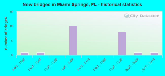
- New bridges - historical statistics
- 11930-1939
- 11940-1949
- 101960-1969
- 81990-1999
- 12000-2009
- 12010-2019


- Bridge Condition - Deck
- 10.0%Excellent
- 30.0%Very good
- 60.0%Good

- Bridge Condition - Superstructure
- 40.0%Very good
- 30.0%Good
- 10.0%Satisfactory
- 20.0%Fair

- Bridge Condition - Substructure
- 50.0%Very good
- 50.0%Good

- Bridge Condition - Channel
- 14.3%Excellent
- 57.1%Very good
- 28.6%Good
Find on map >> Show street view
Structure Number: 870024, Location: SR 112 over LeJuene Rd (Lat: 25.806875, Lng: -80.263972), Route carried "on" structure: Ramp State highway 112, Year Built: 1962, Year Reconstructed: 1990, Status: Open, Structure Length: 15.18m (49.80ft), Average Daily Traffic: 11,500 (year 2021), Truck Traffic: 7%, Average Future Daily Traffic: 19,952 (year 2042), Design Load: HS 20, Features Intersected: SR 953 (NW 42nd Ave)
Minimum Vertical Clearance: 30+ m (98+ ft), Kilometerpoint: 0.013, Lanes on structure: 1, Lanes under structure: 7, Base Highway Network: Yes, Toll: On toll road, Owner: State Toll Authority, Approaching Roadway Width: 8.5m (27.9ft), Skew: 9 degrees, Material/Design: Steel continuous, Design/Construction: Stringer/Multi-beam, Number Of Spans In Main Unit: 7, Number Of Approach Spans: 1, Length of Maximum Span: 24.7m (81.0ft), Curb-To-Curb Width: 8.5m (27.9ft), Out-to-Out Width: 9.8m (32.2ft)
Condition: Deck: Good, Superstructure: Good, Substructure: Good, Operating Rating: 29.3 metric tons, Method Used To Determine Operating Rating: Load and Resistance Factor (LRFR), Inventory Rating: 22.6 metric tons, Method Used To Determine Inventory Rating: Load and Resistance Factor (LRFR), Structural Evaluation: Somewhat better than minimum adequacy, Deck Geometry: Superior to present desirable criteria, Underclear: Meets minimum limits, Approach Roadway Alignment: Better than present minimum criteria, Designated Inspection Frequency: Every 24 months, Critical Feature Inspection Frequency: Every 24 months, Inspection Date: March 2021, Critical Feature Inspection Date: March 2021, Deck Structure Type: Concrete Cast-file-Place, Wearing Surface/Protective System: Wearing Surface: Monolithic Concrete
Find on map >> Show street view
Structure Number: 870025, Location: On Ramp from NB SR 953 (Lat: 25.808622, Lng: -80.262211), Route carried "on" structure: Ramp State highway 112, Year Built: 1961, Year Reconstructed: 1990, Status: Open, Structure Length: 16.61m (54.49ft), Average Daily Traffic: 29,750 (year 2021), Truck Traffic: 5%, Average Future Daily Traffic: 51,616 (year 2042), Design Load: HS 20, Features Intersected: SR 948 & Miami River
Minimum Vertical Clearance: 30+ m (98+ ft), Kilometerpoint: 1.633, Lanes on structure: 3, Lanes under structure: 10, Base Highway Network: Yes, Toll: On toll road, Owner: State Toll Authority, Approaching Roadway Width: 12.1m (39.7ft), Skew: 9 degrees, Material/Design: Steel continuous, Design/Construction: Stringer/Multi-beam, Number Of Spans In Main Unit: 3, Number Of Approach Spans: 3, Length of Maximum Span: 37.5m (123.0ft), Curb-To-Curb Width: 12.1m (39.7ft), Out-to-Out Width: 14.1m (46.3ft)
Condition: Deck: Good, Superstructure: Good, Substructure: Very good, Channel: Very good, Operating Rating: 67.3 metric tons, Method Used To Determine Operating Rating: Load Factor (LF), Inventory Rating: 40.4 metric tons, Method Used To Determine Inventory Rating: Load Factor (LF), Structural Evaluation: Better than present minimum criteria, Deck Geometry: High priority of corrective action, Underclear: Somewhat better than minimum adequacy, Waterway Adequacy: Superior to present desirable criteria, Approach Roadway Alignment: Better than present minimum criteria, Designated Inspection Frequency: Every 24 months, Critical Feature Inspection Frequency: Every 24 months, Inspection Date: March 2021, Critical Feature Inspection Date: March 2021, Deck Structure Type: Concrete Cast-file-Place
Find on map >> Show street view
Structure Number: 870237, Location: SR 112 over US 27 (Lat: 25.808333, Lng: -80.261208), Route carried "on" structure: State highway 112, Year Built: 1961, Status: Open, Structure Length: 30.48m (100.00ft), Average Daily Traffic: 56,250 (year 2021), Truck Traffic: 4%, Average Future Daily Traffic: 97,594 (year 2042), Design Load: HS 20, Features Intersected: US27/SR 948/MIAMI CANAL
Minimum Vertical Clearance: 30+ m (98+ ft), Kilometerpoint: 1.740, Lanes on structure: 2, Lanes under structure: 14, Base Highway Network: Yes, Toll: On toll road, Owner: State Toll Authority, Approaching Roadway Width: 9.1m (29.9ft), Material/Design: Steel continuous, Design/Construction: Stringer/Multi-beam, Number Of Spans In Main Unit: 7, Number Of Approach Spans: 4, Length of Maximum Span: 43.0m (141.1ft), Curb or Sidewalk Widths: Left: 0.2m (0.7ft), Right: 0.1m (0.3ft), Curb-To-Curb Width: 9.1m (29.9ft), Out-to-Out Width: 10.4m (34.1ft)
Condition: Deck: Good, Superstructure: Satisfactory, Substructure: Good, Channel: Very good, Operating Rating: 35.9 metric tons, Method Used To Determine Operating Rating: Load Factor (LF), Inventory Rating: 21.6 metric tons, Method Used To Determine Inventory Rating: Load Factor (LF), Structural Evaluation: Somewhat better than minimum adequacy, Deck Geometry: Meets minimum limits, Underclear: Meets minimum limits, Waterway Adequacy: Equal to present desirable criteria, Approach Roadway Alignment: Better than present minimum criteria, Designated Inspection Frequency: Every 24 months, Critical Feature Inspection Frequency: Every 24 months, Inspection Date: March 2021, Critical Feature Inspection Date: March 2021, Deck Structure Type: Concrete Cast-file-Place, Wearing Surface/Protective System: Wearing Surface: Monolithic Concrete
Find on map >> Show street view
Structure Number: 870725, Location: Miami Int'l Airport (Lat: 25.798306, Lng: -80.264778), Route carried "on" structure: Ramp State highway SR112, Year Built: 1991, Status: Open, Structure Length: 48.47m (159.02ft), Average Daily Traffic: 5,700 (year 2020), Truck Traffic: 5%, Average Future Daily Traffic: 9,890 (year 2042), Design Load: HS 20+Mod, Features Intersected: SR 953 (NW 42nd Ave), Facility Carried by Structure: SR 112 EB On Ramp
Minimum Vertical Clearance: 30+ m (98+ ft), Kilometerpoint: 0.198, Lanes on structure: 2, Lanes under structure: 8, Toll: On toll road, Owner: State Toll Authority, Approaching Roadway Width: 12.8m (42.0ft), Skew: 9 degrees, Material/Design: Steel, Design/Construction: Box Beam or Girders - Single/Spread, Number Of Spans In Main Unit: 5, Number Of Approach Spans: 18, Length of Maximum Span: 33.4m (109.6ft), Curb-To-Curb Width: 12.8m (42.0ft), Out-to-Out Width: 13.6m (44.6ft)
Condition: Deck: Good, Superstructure: Good, Substructure: Good, Channel: Very good, Operating Rating: 58.9 metric tons, Method Used To Determine Operating Rating: Load Factor (LF), Inventory Rating: 26.9 metric tons, Method Used To Determine Inventory Rating: Load Factor (LF), Structural Evaluation: Equal to present minimum criteria, Deck Geometry: Superior to present desirable criteria, Underclear: Somewhat better than minimum adequacy, Waterway Adequacy: Equal to present desirable criteria, Approach Roadway Alignment: Equal to present minimum criteria, Designated Inspection Frequency: Every 24 months, Critical Feature Inspection Frequency: Every 24 months, Underwater Inspection Frequency: Every 24 months, Inspection Date: November 2020, Critical Feature Inspection Date: November 2020, Underwater Inspection Date: November 2020, Deck Structure Type: Concrete Cast-file-Place, Wearing Surface/Protective System: Wearing Surface: Monolithic Concrete
Find on map >> Show street view
Structure Number: 870726, Location: Miami Int'l Airport (Lat: 25.806292, Lng: -80.264833), Route carried "on" structure: Ramp State highway 112, Year Built: 1990, Status: Open, Structure Length: 28.99m (95.11ft), Average Daily Traffic: 14,000 (year 2021), Truck Traffic: 4%, Average Future Daily Traffic: 24,290 (year 2042), Design Load: HS 20, Features Intersected: SR 953 (NW 42nd Ave)
Minimum Vertical Clearance: 30+ m (98+ ft), Kilometerpoint: 1.337, Lanes on structure: 2, Lanes under structure: 6, Base Highway Network: Yes, Toll: On toll road, Owner: State Toll Authority, Approaching Roadway Width: 12.2m (40.0ft), Skew: 9 degrees, Material/Design: Prestressed concrete, Design/Construction: Stringer/Multi-beam, Number Of Spans In Main Unit: 13, Length of Maximum Span: 23.5m (77.1ft), Curb-To-Curb Width: 12.2m (40.0ft), Out-to-Out Width: 13.1m (43.0ft)
Condition: Deck: Very good, Superstructure: Very good, Substructure: Very good, Operating Rating: 35.6 metric tons, Method Used To Determine Operating Rating: Load Factor (LF), Inventory Rating: 32.7 metric tons, Method Used To Determine Inventory Rating: Load Factor (LF), Structural Evaluation: Equal to present desirable criteria, Deck Geometry: Superior to present desirable criteria, Underclear: High priority of corrective action, Approach Roadway Alignment: Better than present minimum criteria, Designated Inspection Frequency: Every 24 months, Inspection Date: March 2021, Deck Structure Type: Concrete Cast-file-Place
Find on map >> Show street view
Structure Number: 870727, Location: Miami Int'l Airport (Lat: 25.806389, Lng: -80.264583), Route carried "on" structure: Ramp State highway 112, Year Built: 1990, Status: Open, Structure Length: 33.03m (108.37ft), Average Daily Traffic: 14,000 (year 2021), Truck Traffic: 4%, Average Future Daily Traffic: 24,290 (year 2042), Design Load: HS 20, Features Intersected: SR 953 (NW 42nd Avenue)
Minimum Vertical Clearance: 30+ m (98+ ft), Kilometerpoint: 1.374, Lanes on structure: 2, Lanes under structure: 7, Base Highway Network: Yes, Toll: On toll road, Owner: State Toll Authority, Approaching Roadway Width: 12.1m (39.7ft), Skew: 9 degrees, Material/Design: Prestressed concrete, Design/Construction: Stringer/Multi-beam, Number Of Spans In Main Unit: 12, Number Of Approach Spans: 3, Length of Maximum Span: 23.7m (77.8ft), Curb-To-Curb Width: 12.3m (40.4ft), Out-to-Out Width: 13.0m (42.7ft)
Condition: Deck: Very good, Superstructure: Very good, Substructure: Very good, Operating Rating: 48.4 metric tons, Method Used To Determine Operating Rating: Load Factor (LF), Inventory Rating: 29.0 metric tons, Method Used To Determine Inventory Rating: Load Factor (LF), Structural Evaluation: Better than present minimum criteria, Deck Geometry: Superior to present desirable criteria, Underclear: Meets minimum limits, Approach Roadway Alignment: Better than present minimum criteria, Designated Inspection Frequency: Every 24 months, Inspection Date: March 2021, Deck Structure Type: Concrete Cast-file-Place, Wearing Surface/Protective System: Wearing Surface: Monolithic Concrete
Find on map >> Show street view
Structure Number: 874019, Location: 300 FT N/O NW 20TH ST. (Lat: 25.795028, Lng: -80.245472), Route carried "on" structure: City street , Year Built: 2018, Status: Open, Structure Length: 4.78m (15.68ft), Average Daily Traffic: 9,282 (year 2021), Truck Traffic: 5%, Average Future Daily Traffic: 15,042 (year 2042), Design Load: HL 93, Features Intersected: TAMIAMI CANAL, Facility Carried by Structure: NW SOUTH RIVER DR.
Minimum Vertical Clearance: 30+ m (98+ ft), Kilometerpoint: 2.457, Lanes on structure: 4, Owner: County Highway Agency, Approaching Roadway Width: 14.6m (47.9ft), Navigation Control: Yes ( Vertical Clearance: 2.0m (6.6ft), Horizontal Clearance: 27.4m (89.9ft)), Material/Design: Steel, Design/Construction: Movable - Bascule, Number Of Spans In Main Unit: 1, Number Of Approach Spans: 1, Length of Maximum Span: 37.4m (122.7ft), Curb or Sidewalk Widths: Left: 3.7m (12.1ft), Right: 2.0m (6.6ft), Curb-To-Curb Width: 14.9m (48.9ft), Out-to-Out Width: 22.8m (74.8ft)
Condition: Deck: Excellent, Superstructure: Very good, Substructure: Very good, Channel: Excellent, Structural Evaluation: Equal to present desirable criteria, Deck Geometry: High priority of replacement, Waterway Adequacy: Superior to present desirable criteria, Approach Roadway Alignment: Equal to present minimum criteria, Designated Inspection Frequency: Every 24 months, Critical Feature Inspection Frequency: Every 24 months, Underwater Inspection Frequency: Every 24 months, Other Special Inspection Frequency: Every 12 months, Inspection Date: December 2020, Critical Feature Inspection Date: December 2020, Underwater Inspection Date: December 2020, Other Special Inspection Date: December 2021, Deck Structure Type: Other, Wearing Surface/Protective System: Wearing Surface: Monolithic Concrete
Find on map >> Show street view
Structure Number: 874129, Location: At Okeechobee Rd. (US-27) (Lat: 25.821758, Lng: -80.279692), Route carried "on" structure: City street , Year Built: 1930, Year Reconstructed: 2003, Status: Posted for load, Structure Length: 4.08m (13.39ft), Average Daily Traffic: 11,050 (year 2020), Truck Traffic: 5%, Average Future Daily Traffic: 16,352 (year 2042), Design Load: HS 20, Features Intersected: Miami Canal, Facility Carried by Structure: NB Hook Square
Minimum Vertical Clearance: 4.45m (14.60ft), Kilometerpoint: 0.135, Lanes on structure: 2, Owner: County Highway Agency, Approaching Roadway Width: 7.1m (23.3ft), Material/Design: Steel, Design/Construction: Truss - Thru, Number Of Spans In Main Unit: 1, Length of Maximum Span: 40.4m (132.5ft), Curb or Sidewalk Widths: Left: 0.9m (3.0ft), Right: 0.9m (3.0ft), Curb-To-Curb Width: 7.1m (23.3ft), Out-to-Out Width: 8.9m (29.2ft)
Condition: Deck: Good, Superstructure: Fair, Substructure: Good, Channel: Very good, Operating Rating: 35.9 metric tons, Method Used To Determine Operating Rating: Allowable Stress (AS), Inventory Rating: 25.1 metric tons, Method Used To Determine Inventory Rating: Allowable Stress (AS), Structural Evaluation: Somewhat better than minimum adequacy, Deck Geometry: High priority of replacement, Waterway Adequacy: Equal to present minimum criteria, Approach Roadway Alignment: Better than present minimum criteria, Bridge Posting: Required (Relationship of Operating Rating to Maximum Legal Load: 30.0 - 39.9% below), Length Of Structure Improvement: 4.05m (13.29ft), Designated Inspection Frequency: Every 24 months, Critical Feature Inspection Frequency: Every 12 months, Other Special Inspection Frequency: Every 12 months, Inspection Date: September 2021, Critical Feature Inspection Date: September 2021, Other Special Inspection Date: September 2021, Deck Structure Type: Open Grating
Find on map >> Show street view
Structure Number: 87413, Location: At Okeechobee Rd. US-27 (Lat: 25.822386, Lng: -80.280575), Route carried "on" structure: City street , Year Built: 1941, Year Reconstructed: 2003, Status: Open, Structure Length: 3.38m (11.09ft), Average Daily Traffic: 10,500 (year 2020), Truck Traffic: 5%, Average Future Daily Traffic: 13,500 (year 2042), Design Load: HS 20, Features Intersected: Miami Canal, Facility Carried by Structure: Curtiss Parkway
Minimum Vertical Clearance: 30+ m (98+ ft), Kilometerpoint: 0.048, Lanes on structure: 2, Owner: County Highway Agency, Approaching Roadway Width: 6.4m (21.0ft), Material/Design: Steel, Design/Construction: Truss - Thru, Number Of Spans In Main Unit: 2, Length of Maximum Span: 21.9m (71.9ft), Curb-To-Curb Width: 6.4m (21.0ft), Out-to-Out Width: 6.7m (22.0ft)
Condition: Deck: Good, Superstructure: Fair, Substructure: Good, Channel: Good, Operating Rating: 41.8 metric tons, Method Used To Determine Operating Rating: Allowable Stress (AS), Inventory Rating: 29.8 metric tons, Method Used To Determine Inventory Rating: Allowable Stress (AS), Structural Evaluation: Somewhat better than minimum adequacy, Deck Geometry: High priority of replacement, Waterway Adequacy: Equal to present desirable criteria, Approach Roadway Alignment: Better than present minimum criteria, Length Of Structure Improvement: 4.05m (13.29ft), Designated Inspection Frequency: Every 24 months, Critical Feature Inspection Frequency: Every 24 months, Underwater Inspection Frequency: Every 24 months, Inspection Date: September 2021, Critical Feature Inspection Date: September 2021, Underwater Inspection Date: September 2021, Deck Structure Type: Open Grating
Find on map >> Show street view
Structure Number: 874145, Location: 30Ft. S of Okeechobee Rd. (Lat: 25.816794, Lng: -80.273028), Route carried "on" structure: City street , Year Built: 2003, Status: Open, Structure Length: 3.81m (12.50ft), Average Daily Traffic: 24,090 (year 2020), Truck Traffic: 5%, Average Future Daily Traffic: 39,044 (year 2042), Design Load: HS 20, Features Intersected: Miami Canal, Facility Carried by Structure: SE 4th Avenue
Minimum Vertical Clearance: 30+ m (98+ ft), Kilometerpoint: 0.933, Lanes on structure: 4, Owner: County Highway Agency, Approaching Roadway Width: 14.0m (45.9ft), Skew: 4 degrees, Material/Design: Prestressed concrete, Design/Construction: Stringer/Multi-beam, Number Of Spans In Main Unit: 2, Length of Maximum Span: 19.1m (62.7ft), Curb or Sidewalk Widths: Left: 0.0m, Right: 1.8m (5.9ft), Curb-To-Curb Width: 14.4m (47.2ft), Out-to-Out Width: 17.1m (56.1ft)
Condition: Deck: Very good, Superstructure: Very good, Substructure: Very good, Channel: Good, Operating Rating: 39.9 metric tons, Method Used To Determine Operating Rating: Load Factor (LF), Inventory Rating: 23.9 metric tons, Method Used To Determine Inventory Rating: Load Factor (LF), Structural Evaluation: Somewhat better than minimum adequacy, Deck Geometry: High priority of replacement, Waterway Adequacy: Better than present minimum criteria, Approach Roadway Alignment: Somewhat better than minimum adequacy, Designated Inspection Frequency: Every 24 months, Underwater Inspection Frequency: Every 24 months, Inspection Date: March 2021, Underwater Inspection Date: March 2021, Deck Structure Type: Concrete Cast-file-Place
Find on map >> Show street view
Structure Number: 870024, Location: SR 112 over LeJuene Rd (Lat: 25.806875, Lng: -80.263972), Route carried "under" structure: State highway 953, Year Built: 1962, Structure Length: 0. m, Average Daily Traffic: 37,500 (year 2021), Truck Traffic: 2%, Features Intersected: SR 953 (NW 42nd Ave), Facility Carried by Structure: SR 112 WB Off Ramp
Minimum Vertical Clearance: 5.67m (18.60ft), Kilometerpoint: 0.000, Lanes on structure: 1, Lanes under structure: 6, Material/Design: Steel continuous, Design/Construction: Stringer/Multi-beam, Length of Maximum Span: 24.7m (81.0ft)
Find on map >> Show street view
Structure Number: 870024, Location: SR 112 over LeJuene Rd (Lat: 25.806875, Lng: -80.263972), Route carried "under" structure: Ramp State highway 112, Year Built: 1962, Structure Length: 0. m, Average Daily Traffic: 11,500 (year 2021), Truck Traffic: 7%, Features Intersected: SR 953 (NW 42nd Ave)
Minimum Vertical Clearance: 5.36m (17.59ft), Kilometerpoint: 0.322, Lanes on structure: 1, Lanes under structure: 1, Toll: On toll road, Material/Design: Steel continuous, Design/Construction: Stringer/Multi-beam, Length of Maximum Span: 24.7m (81.0ft)
Find on map >> Show street view
Structure Number: 870025, Location: On Ramp from NB SR 953 (Lat: 25.808622, Lng: -80.262211), Route carried "under" structure: Business State highway 948, Year Built: 1961, Structure Length: 0. m, Average Daily Traffic: 50,500 (year 2021), Truck Traffic: 9%, Features Intersected: SR 948 & Miami River, Facility Carried by Structure: SR 112 EB On Ramp
Minimum Vertical Clearance: 4.60m (15.09ft), Kilometerpoint: 24.481, Lanes on structure: 3, Lanes under structure: 5, Material/Design: Steel continuous, Design/Construction: Stringer/Multi-beam, Length of Maximum Span: 37.5m (123.0ft)
Find on map >> Show street view
Structure Number: 870025, Location: On Ramp from NB SR 953 (Lat: 25.808622, Lng: -80.262211), Route carried "under" structure: City street , Year Built: 1961, Structure Length: 0. m, Average Daily Traffic: 51,500 (year 2021), Truck Traffic: 11%, Features Intersected: SR 948 & Miami River, Facility Carried by Structure: SR 112 EB On Ramp
Minimum Vertical Clearance: 4.79m (15.72ft), Kilometerpoint: 6.135, Lanes on structure: 3, Lanes under structure: 5, Material/Design: Steel continuous, Design/Construction: Stringer/Multi-beam, Length of Maximum Span: 37.5m (123.0ft)
Find on map >> Show street view
Structure Number: 870237, Location: SR 112 over US 27 (Lat: 25.808333, Lng: -80.261208), Route carried "under" structure: US 27, Year Built: 1961, Structure Length: 0. m, Average Daily Traffic: 44,500 (year 2021), Truck Traffic: 29%, Features Intersected: US27/SR 948/MIAMI CANAL, Facility Carried by Structure: SR 112 WB
Minimum Vertical Clearance: 4.57m (14.99ft), Kilometerpoint: 24.512, Lanes on structure: 2, Lanes under structure: 4, Material/Design: Steel continuous, Design/Construction: Stringer/Multi-beam, Length of Maximum Span: 43.0m (141.1ft)
Find on map >> Show street view
Structure Number: 870237, Location: SR 112 over US 27 (Lat: 25.808333, Lng: -80.261208), Route carried "under" structure: State highway 948, Year Built: 1961, Structure Length: 0. m, Average Daily Traffic: 20,000 (year 2021), Truck Traffic: 2%, Features Intersected: US27/SR 948/MIAMI CANAL, Facility Carried by Structure: SR 112 WB
Minimum Vertical Clearance: 4.63m (15.19ft), Kilometerpoint: 6.320, Lanes on structure: 2, Lanes under structure: 4, Material/Design: Steel continuous, Design/Construction: Stringer/Multi-beam, Length of Maximum Span: 43.0m (141.1ft)
Find on map >> Show street view
Structure Number: 870237, Location: SR 112 over US 27 (Lat: 25.808333, Lng: -80.261208), Route carried "under" structure: County highway , Year Built: 1961, Structure Length: 0. m, Average Daily Traffic: 8,000 (year 2021), Truck Traffic: 2%, Features Intersected: US27/SR 948/MIAMI CANAL, Facility Carried by Structure: SR 112 WB
Minimum Vertical Clearance: 6.64m (21.78ft), Kilometerpoint: 0.000, Lanes on structure: 2, Lanes under structure: 6, Material/Design: Steel continuous, Design/Construction: Stringer/Multi-beam, Length of Maximum Span: 43.0m (141.1ft)
Find on map >> Show street view
Structure Number: 870725, Location: Miami Int'l Airport (Lat: 25.798306, Lng: -80.264778), Route carried "under" structure: Ramp State highway 953, Year Built: 1991, Structure Length: 0. m, Average Daily Traffic: 59,500 (year 2020), Truck Traffic: 5%, Features Intersected: SR 953 (NW 42nd Ave), Facility Carried by Structure: SR 112 EB On Ramp
Minimum Vertical Clearance: 5.64m (18.50ft), Kilometerpoint: 7.743, Lanes on structure: 2, Lanes under structure: 2, Material/Design: Steel, Design/Construction: Box Beam or Girders - Single/Spread, Length of Maximum Span: 33.4m (109.6ft)
Find on map >> Show street view
Structure Number: 870725, Location: Miami Int'l Airport (Lat: 25.798306, Lng: -80.264778), Route carried "under" structure: State highway 953, Year Built: 1991, Structure Length: 0. m, Average Daily Traffic: 59,500 (year 2020), Truck Traffic: 5%, Features Intersected: SR 953 (NW 42nd Ave), Facility Carried by Structure: SR 112 EB On Ramp
Minimum Vertical Clearance: 5.33m (17.49ft), Kilometerpoint: 7.743, Lanes on structure: 2, Lanes under structure: 6, Material/Design: Steel, Design/Construction: Box Beam or Girders - Single/Spread, Length of Maximum Span: 33.4m (109.6ft)
Find on map >> Show street view
Structure Number: 870726, Location: Miami Int'l Airport (Lat: 25.806292, Lng: -80.264833), Route carried "under" structure: State highway 953, Year Built: 1990, Structure Length: 0. m, Average Daily Traffic: 95,000 (year 2021), Truck Traffic: 6%, Features Intersected: SR 953 (NW 42nd Ave), Facility Carried by Structure: SR 112 EB On Ramp
Minimum Vertical Clearance: 5.18m (16.99ft), Kilometerpoint: 8.970, Lanes on structure: 2, Lanes under structure: 6, Material/Design: Prestressed concrete, Design/Construction: Stringer/Multi-beam, Length of Maximum Span: 23.5m (77.1ft)
Find on map >> Show street view
Structure Number: 870727, Location: Miami Int'l Airport (Lat: 25.806389, Lng: -80.264583), Route carried "under" structure: Ramp State highway 112, Year Built: 1990, Structure Length: 0. m, Average Daily Traffic: 28,450 (year 2021), Truck Traffic: 2%, Features Intersected: SR 953 (NW 42nd Avenue)
Minimum Vertical Clearance: 4.88m (16.01ft), Kilometerpoint: 0.000, Lanes on structure: 2, Lanes under structure: 1, Toll: On toll road, Material/Design: Prestressed concrete, Design/Construction: Stringer/Multi-beam, Length of Maximum Span: 23.7m (77.8ft)
Find on map >> Show street view
Structure Number: 870727, Location: Miami Int'l Airport (Lat: 25.806389, Lng: -80.264583), Route carried "under" structure: Business State highway 953, Year Built: 1990, Structure Length: 0. m, Average Daily Traffic: 87,500 (year 2021), Truck Traffic: 2%, Features Intersected: SR 953 (NW 42nd Avenue), Facility Carried by Structure: SR 112 WB Off Ramp
Minimum Vertical Clearance: 4.88m (16.01ft), Kilometerpoint: 0.000, Lanes on structure: 2, Lanes under structure: 6, Material/Design: Prestressed concrete, Design/Construction: Stringer/Multi-beam, Length of Maximum Span: 23.7m (77.8ft)