Bridge Statistics for Mechanicsburg, Pennsylvania (PA)
Condition, Traffic, Stress, Structural Evaluation, Project Costs
- National Bridge Inventory (NBI) Statistics
- 50Number of bridges
- 410ft / 125mTotal length
- $2,148,000Total costs
- 814,370Total average daily traffic
- 132,150Total average daily truck traffic
- National Bridge Inventory (NBI) Registered Bridges for Mechanicsburg
- No street view available for this location
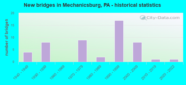
- New bridges - historical statistics
- 41940-1949
- 81950-1959
- 91970-1979
- 21980-1989
- 171990-1999
- 82000-2009
- 12010-2019
- 12020-2022


- Bridge Condition - Deck
- 68.2%Good
- 27.3%Satisfactory
- 4.5%Fair

- Bridge Condition - Superstructure
- 9.1%Very good
- 54.5%Good
- 36.4%Satisfactory

- Bridge Condition - Substructure
- 72.7%Good
- 18.2%Satisfactory
- 9.1%Fair

- Bridge Condition - Channel
- 14.3%Very good
- 28.6%Good
- 42.9%Satisfactory
- 14.3%Fair

- Bridge Condition - Culverts
- 50.0%Very good
- 50.0%Satisfactory
Find on map >> Show street view
Structure Number: 1PA0099, Location: 0.5 MI S OF US 11 (Lat: 40.241694, Lng: -76.999722), Route carried "on" structure: Other road , Year Built: 2006, Status: Open, Structure Length: 0.71m (2.33ft), Average Daily Traffic: 1,500 (year 2003), Truck Traffic: 5%, Average Future Daily Traffic: 1,800 (year 2035), Features Intersected: CREEK, Facility Carried by Structure: SALEM CHURCH ROAD
Minimum Vertical Clearance: 30+ m (98+ ft), Kilometerpoint: 0.000, Lanes on structure: 2, Owner: Navy/Marines, Approaching Roadway Width: 11.6m (38.1ft), Skew: 1 degrees, Material/Design: Concrete, Design/Construction: Culvert, Number Of Spans In Main Unit: 1, Length of Maximum Span: 6.7m (22.0ft), Curb-To-Curb Width: 10.9m (35.8ft), Out-to-Out Width: 12.5m (41.0ft)
Condition: Channel: Satisfactory, Culverts: Satisfactory, Operating Rating: 36.3 metric tons, Method Used To Determine Operating Rating: Field evaluation and documented engineering judgment, Inventory Rating: 32.6 metric tons, Method Used To Determine Inventory Rating: Field evaluation and documented engineering judgment, Structural Evaluation: Equal to present minimum criteria, Deck Geometry: Equal to present minimum criteria, Waterway Adequacy: Equal to present minimum criteria, Approach Roadway Alignment: Equal to present desirable criteria, Length Of Structure Improvement: 0.71m (2.33ft), Designated Inspection Frequency: Every 24 months, Inspection Date: July 2021, Bridge Improvement Cost: $3,000, Roadway Improvement Cost: $23,000, Total Project Cost: $26,000 ( Estimate for 2021), Deck Structure Type: Concrete Precast Panels, Wearing Surface/Protective System: Wearing Surface: Bituminous
Find on map >> Show street view
Structure Number: 11727, Location: 2 MI E CURWENSVILLE (Lat: 40.973864, Lng: -78.490533), Route carried "on" structure: State highway , Year Built: 1989, Status: Open, Structure Length: 6.37m (20.90ft), Average Daily Traffic: 963 (year 2022), Truck Traffic: 1%, Average Future Daily Traffic: 1,118 (year 2041), Design Load: HS 25 or greater, Features Intersected: W BR SUSQUEHANNA RIVER, Facility Carried by Structure: SR 2024
Minimum Vertical Clearance: 30+ m (98+ ft), Kilometerpoint: 0.716, Lanes on structure: 2, Owner: State Highway Agency, Approaching Roadway Width: 8.5m (27.9ft), Skew: 2 degrees, Material/Design: Prestressed concrete continuous, Design/Construction: Stringer/Multi-beam, Number Of Spans In Main Unit: 2, Length of Maximum Span: 30.8m (101.0ft), Curb or Sidewalk Widths: Left: 0.2m (0.7ft), Right: 0.2m (0.7ft), Curb-To-Curb Width: 9.8m (32.2ft), Out-to-Out Width: 10.5m (34.4ft)
Condition: Deck: Good, Superstructure: Satisfactory, Substructure: Good, Channel: Very good, Operating Rating: 95.3 metric tons, Method Used To Determine Operating Rating: Load Factor (LF), Inventory Rating: 48.1 metric tons, Method Used To Determine Inventory Rating: Load Factor (LF), Structural Evaluation: Equal to present minimum criteria, Deck Geometry: Equal to present minimum criteria, Waterway Adequacy: Equal to present desirable criteria, Approach Roadway Alignment: Better than present minimum criteria, Length Of Structure Improvement: 6.40m (21.00ft), Designated Inspection Frequency: Every 24 months, Inspection Date: May 2021, Deck Structure Type: Concrete Cast-file-Place, Wearing Surface/Protective System: Wearing Surface: Monolithic Concrete, Deck Protection: Epoxy Coated Reinforcing
Find on map >> Show street view
Structure Number: 13705, Location: 1 MI.S. MOUNT ZION (Lat: 40.273781, Lng: -77.007669), Route carried "on" structure: Interstate 81, Year Built: 1973, Year Reconstructed: 2017, Status: Open, Structure Length: 5.00m (16.40ft), Average Daily Traffic: 39,613 (year 2021), Truck Traffic: 21%, Average Future Daily Traffic: 51,255 (year 2032), Design Load: HS 20, Features Intersected: 1011 Lambs Gap
Minimum Vertical Clearance: 30+ m (98+ ft), Kilometerpoint: 52.622, Lanes on structure: 3, Lanes under structure: 2, Base Highway Network: Yes, Owner: State Highway Agency, Approaching Roadway Width: 17.1m (56.1ft), Skew: 10 degrees, Material/Design: Prestressed concrete, Design/Construction: Stringer/Multi-beam, Number Of Spans In Main Unit: 3, Length of Maximum Span: 26.5m (86.9ft), Curb or Sidewalk Widths: Left: 0.2m (0.7ft), Right: 0.2m (0.7ft), Curb-To-Curb Width: 15.6m (51.2ft), Out-to-Out Width: 16.9m (55.4ft)
Condition: Deck: Satisfactory, Superstructure: Satisfactory, Substructure: Satisfactory, Operating Rating: 68.9 metric tons, Method Used To Determine Operating Rating: Load Factor (LF), Inventory Rating: 20.9 metric tons, Method Used To Determine Inventory Rating: Load Factor (LF), Structural Evaluation: Somewhat better than minimum adequacy, Deck Geometry: Somewhat better than minimum adequacy, Underclear: Equal to present minimum criteria, Approach Roadway Alignment: Equal to present desirable criteria, Length Of Structure Improvement: 5.90m (19.36ft), Designated Inspection Frequency: Every 24 months, Inspection Date: May 2020, Deck Structure Type: Concrete Cast-file-Place, Wearing Surface/Protective System: Wearing Surface: Latex Concrete
Find on map >> Show street view
Structure Number: 13706, Location: .2 MI.W. OF L.R. 1067 (Lat: 40.274792, Lng: -77.007689), Route carried "on" structure: Interstate 81, Year Built: 1973, Year Reconstructed: 2017, Status: Open, Structure Length: 5.18m (16.99ft), Average Daily Traffic: 40,285 (year 2021), Truck Traffic: 16%, Average Future Daily Traffic: 49,151 (year 2035), Design Load: HS 20, Features Intersected: SR 1011
Minimum Vertical Clearance: 30+ m (98+ ft), Kilometerpoint: 52.630, Lanes on structure: 3, Lanes under structure: 2, Base Highway Network: Yes, Owner: State Highway Agency, Approaching Roadway Width: 16.5m (54.1ft), Skew: 11 degrees, Material/Design: Prestressed concrete, Design/Construction: Stringer/Multi-beam, Number Of Spans In Main Unit: 3, Length of Maximum Span: 26.8m (87.9ft), Curb or Sidewalk Widths: Left: 0.2m (0.7ft), Right: 0.2m (0.7ft), Curb-To-Curb Width: 15.6m (51.2ft), Out-to-Out Width: 17.6m (57.7ft)
Condition: Deck: Good, Superstructure: Satisfactory, Substructure: Satisfactory, Operating Rating: 67.1 metric tons, Method Used To Determine Operating Rating: Load Factor (LF), Inventory Rating: 24.5 metric tons, Method Used To Determine Inventory Rating: Load Factor (LF), Structural Evaluation: Equal to present minimum criteria, Deck Geometry: Somewhat better than minimum adequacy, Underclear: Equal to present minimum criteria, Approach Roadway Alignment: Equal to present desirable criteria, Length Of Structure Improvement: 6.30m (20.67ft), Designated Inspection Frequency: Every 24 months, Inspection Date: May 2020, Bridge Improvement Cost: $71,000, Roadway Improvement Cost: $209,000, Total Project Cost: $960,000, Deck Structure Type: Concrete Cast-file-Place, Wearing Surface/Protective System: Wearing Surface: Latex Concrete
Find on map >> Show street view
Structure Number: 13749, Location: .2MI.S. OF I-81 (Lat: 40.268611, Lng: -77.000250), Route carried "on" structure: State highway 581, Year Built: 1995, Status: Open, Structure Length: 3.14m (10.30ft), Average Daily Traffic: 23,321 (year 2021), Truck Traffic: 13%, Average Future Daily Traffic: 31,303 (year 2032), Design Load: HS 25 or greater, Features Intersected: LOCUST LANE
Minimum Vertical Clearance: 30+ m (98+ ft), Kilometerpoint: 0.000, Lanes on structure: 3, Lanes under structure: 2, Base Highway Network: Yes, Owner: State Highway Agency, Approaching Roadway Width: 15.2m (49.9ft), Skew: 10 degrees, Material/Design: Prestressed concrete, Design/Construction: Stringer/Multi-beam, Number Of Spans In Main Unit: 1, Length of Maximum Span: 30.5m (100.1ft), Curb or Sidewalk Widths: Left: 0.2m (0.7ft), Right: 0.2m (0.7ft), Curb-To-Curb Width: 17.1m (56.1ft), Out-to-Out Width: 18.1m (59.4ft)
Condition: Deck: Good, Superstructure: Good, Substructure: Good, Operating Rating: 89.8 metric tons, Method Used To Determine Operating Rating: Load Factor (LF), Inventory Rating: 48.1 metric tons, Method Used To Determine Inventory Rating: Load Factor (LF), Structural Evaluation: Better than present minimum criteria, Deck Geometry: Equal to present minimum criteria, Underclear: Superior to present desirable criteria, Approach Roadway Alignment: Equal to present desirable criteria, Length Of Structure Improvement: 3.90m (12.80ft), Designated Inspection Frequency: Every 24 months, Inspection Date: June 2020, Deck Structure Type: Concrete Cast-file-Place, Wearing Surface/Protective System: Wearing Surface: Monolithic Concrete, Deck Protection: Epoxy Coated Reinforcing
Find on map >> Show street view
Structure Number: 13751, Location: 2.0 MI SOUTH OF I-81 (Lat: 40.267886, Lng: -76.999517), Route carried "on" structure: State highway 581, Year Built: 1995, Status: Open, Structure Length: 3.14m (10.30ft), Average Daily Traffic: 22,523 (year 2021), Truck Traffic: 14%, Average Future Daily Traffic: 28,531 (year 2032), Design Load: HS 25 or greater, Features Intersected: LOCUST LANE
Minimum Vertical Clearance: 30+ m (98+ ft), Kilometerpoint: 0.000, Lanes on structure: 2, Lanes under structure: 2, Base Highway Network: Yes, Owner: State Highway Agency, Approaching Roadway Width: 11.6m (38.1ft), Skew: 10 degrees, Material/Design: Prestressed concrete, Design/Construction: Stringer/Multi-beam, Number Of Spans In Main Unit: 1, Length of Maximum Span: 30.5m (100.1ft), Curb or Sidewalk Widths: Left: 0.2m (0.7ft), Right: 0.2m (0.7ft), Curb-To-Curb Width: 13.7m (44.9ft), Out-to-Out Width: 14.8m (48.6ft)
Condition: Deck: Satisfactory, Superstructure: Good, Substructure: Good, Operating Rating: 89.8 metric tons, Method Used To Determine Operating Rating: Load Factor (LF), Inventory Rating: 37.2 metric tons, Method Used To Determine Inventory Rating: Load Factor (LF), Structural Evaluation: Better than present minimum criteria, Deck Geometry: Superior to present desirable criteria, Underclear: Equal to present minimum criteria, Approach Roadway Alignment: Equal to present desirable criteria, Length Of Structure Improvement: 3.90m (12.80ft), Designated Inspection Frequency: Every 24 months, Inspection Date: June 2020, Deck Structure Type: Concrete Cast-file-Place, Wearing Surface/Protective System: Wearing Surface: Monolithic Concrete, Deck Protection: Epoxy Coated Reinforcing
Find on map >> Show street view
Structure Number: 13752, Location: 1.1 MILES NORTH OF US11 (Lat: 40.252306, Lng: -76.987808), Route carried "on" structure: State highway 581, Year Built: 1995, Status: Open, Structure Length: 20.54m (67.39ft), Average Daily Traffic: 24,765 (year 2022), Truck Traffic: 11%, Average Future Daily Traffic: 31,477 (year 2032), Design Load: HS 25 or greater, Features Intersected: CONODOGUINET CREEK
Minimum Vertical Clearance: 30+ m (98+ ft), Kilometerpoint: 1.751, Lanes on structure: 3, Base Highway Network: Yes, Owner: State Highway Agency, Approaching Roadway Width: 16.5m (54.1ft), Skew: 5 degrees, Material/Design: Prestressed concrete continuous, Design/Construction: Stringer/Multi-beam, Number Of Spans In Main Unit: 5, Length of Maximum Span: 40.5m (132.9ft), Curb or Sidewalk Widths: Left: 0.2m (0.7ft), Right: 0.2m (0.7ft), Curb-To-Curb Width: 16.5m (54.1ft), Out-to-Out Width: 17.4m (57.1ft)
Condition: Deck: Satisfactory, Superstructure: Good, Substructure: Good, Channel: Fair, Operating Rating: 89.8 metric tons, Method Used To Determine Operating Rating: Load Factor (LF), Inventory Rating: 49.0 metric tons, Method Used To Determine Inventory Rating: Load Factor (LF), Structural Evaluation: Better than present minimum criteria, Deck Geometry: Equal to present minimum criteria, Waterway Adequacy: Equal to present desirable criteria, Approach Roadway Alignment: Equal to present desirable criteria, Length Of Structure Improvement: 21.20m (69.55ft), Designated Inspection Frequency: Every 24 months, Inspection Date: June 2020, Deck Structure Type: Concrete Cast-file-Place, Wearing Surface/Protective System: Wearing Surface: Monolithic Concrete, Deck Protection: Epoxy Coated Reinforcing
Find on map >> Show street view
Structure Number: 13754, Location: 1MILE NORTH OF US11 (Lat: 40.250336, Lng: -76.986581), Route carried "on" structure: State highway , Year Built: 1995, Status: Open, Structure Length: 6.74m (22.11ft), Average Daily Traffic: 3,828 (year 2022), Truck Traffic: 4%, Average Future Daily Traffic: 5,926 (year 2032), Design Load: HS 25 or greater, Features Intersected: PA 581;SR 0581 CAPT.BELT, Facility Carried by Structure: SKYPORT RD. T-613
Minimum Vertical Clearance: 30+ m (98+ ft), Kilometerpoint: 0.000, Lanes on structure: 2, Lanes under structure: 5, Owner: State Highway Agency, Approaching Roadway Width: 10.7m (35.1ft), Material/Design: Prestressed concrete, Design/Construction: Stringer/Multi-beam, Number Of Spans In Main Unit: 2, Length of Maximum Span: 33.5m (109.9ft), Curb or Sidewalk Widths: Left: 1.5m (4.9ft), Right: 0.5m (1.6ft), Curb-To-Curb Width: 10.9m (35.8ft), Out-to-Out Width: 13.3m (43.6ft)
Condition: Deck: Satisfactory, Superstructure: Good, Substructure: Good, Operating Rating: 89.8 metric tons, Method Used To Determine Operating Rating: Load Factor (LF), Inventory Rating: 49.9 metric tons, Method Used To Determine Inventory Rating: Load Factor (LF), Structural Evaluation: Better than present minimum criteria, Deck Geometry: Somewhat better than minimum adequacy, Underclear: High priority of corrective action, Approach Roadway Alignment: Equal to present desirable criteria, Length Of Structure Improvement: 7.70m (25.26ft), Designated Inspection Frequency: Every 24 months, Inspection Date: June 2020, Deck Structure Type: Concrete Cast-file-Place, Wearing Surface/Protective System: Wearing Surface: Monolithic Concrete, Deck Protection: Epoxy Coated Reinforcing
Find on map >> Show street view
Structure Number: 13826, Location: 1.2 MI S OF I-81 & PA 581 (Lat: 40.258406, Lng: -76.992478), Route carried "on" structure: State highway , Year Built: 1995, Status: Open, Structure Length: 6.04m (19.82ft), Average Daily Traffic: 9,086 (year 2022), Truck Traffic: 2%, Average Future Daily Traffic: 13,611 (year 2032), Design Load: HS 25 or greater, Features Intersected: PA 581; SR 0581, Facility Carried by Structure: 1002 Creekview Rd
Minimum Vertical Clearance: 30+ m (98+ ft), Kilometerpoint: 0.000, Lanes on structure: 2, Lanes under structure: 4, Owner: State Highway Agency, Approaching Roadway Width: 19.5m (64.0ft), Material/Design: Prestressed concrete, Design/Construction: Stringer/Multi-beam, Number Of Spans In Main Unit: 2, Length of Maximum Span: 29.0m (95.1ft), Curb or Sidewalk Widths: Left: 0.2m (0.7ft), Right: 0.2m (0.7ft), Curb-To-Curb Width: 19.7m (64.6ft), Out-to-Out Width: 20.6m (67.6ft)
Condition: Deck: Good, Superstructure: Satisfactory, Substructure: Good, Operating Rating: 83.5 metric tons, Method Used To Determine Operating Rating: Load Factor (LF), Inventory Rating: 42.6 metric tons, Method Used To Determine Inventory Rating: Load Factor (LF), Structural Evaluation: Equal to present minimum criteria, Deck Geometry: Superior to present desirable criteria, Underclear: Superior to present desirable criteria, Approach Roadway Alignment: Equal to present desirable criteria, Length Of Structure Improvement: 6.90m (22.64ft), Designated Inspection Frequency: Every 24 months, Inspection Date: June 2020, Deck Structure Type: Concrete Cast-file-Place, Wearing Surface/Protective System: Wearing Surface: Monolithic Concrete, Deck Protection: Epoxy Coated Reinforcing
Find on map >> Show street view
Structure Number: 13849, Location: 1.5 MI.S. OF GOOD HOPE (Lat: 40.253469, Lng: -77.003164), Route carried "on" structure: State highway , Year Built: 1984, Status: Open, Structure Length: 10.49m (34.42ft), Average Daily Traffic: 3,579 (year 2021), Truck Traffic: 3%, Average Future Daily Traffic: 4,045 (year 2032), Design Load: HS 25 or greater, Features Intersected: CONODOQUINET CREEK, Facility Carried by Structure: SR 1011
Minimum Vertical Clearance: 30+ m (98+ ft), Kilometerpoint: 3.993, Lanes on structure: 2, Owner: State Highway Agency, Approaching Roadway Width: 7.9m (25.9ft), Skew: 2 degrees, Material/Design: Prestressed concrete, Design/Construction: Stringer/Multi-beam, Number Of Spans In Main Unit: 4, Length of Maximum Span: 27.4m (89.9ft), Curb or Sidewalk Widths: Left: 0.2m (0.7ft), Right: 1.5m (4.9ft), Curb-To-Curb Width: 8.5m (27.9ft), Out-to-Out Width: 11.5m (37.7ft)
Condition: Deck: Good, Superstructure: Good, Substructure: Fair, Channel: Satisfactory, Operating Rating: 62.6 metric tons, Method Used To Determine Operating Rating: Load Factor (LF), Inventory Rating: 37.2 metric tons, Method Used To Determine Inventory Rating: Load Factor (LF), Structural Evaluation: Somewhat better than minimum adequacy, Deck Geometry: Meets minimum limits, Waterway Adequacy: Superior to present desirable criteria, Approach Roadway Alignment: Somewhat better than minimum adequacy, Length Of Structure Improvement: 11.50m (37.73ft), Designated Inspection Frequency: Every 24 months, Inspection Date: May 2020, Deck Structure Type: Concrete Cast-file-Place, Wearing Surface/Protective System: Wearing Surface: Monolithic Concrete, Deck Protection: Epoxy Coated Reinforcing
Find on map >> Show street view
Structure Number: 13877, Location: 0.2 MI SOUTH OF PA TPK (Lat: 40.191108, Lng: -76.978789), Route carried "on" structure: State highway , Year Built: 1995, Status: Open, Structure Length: 3.87m (12.70ft), Average Daily Traffic: 11,044 (year 2022), Truck Traffic: 3%, Average Future Daily Traffic: 13,153 (year 2032), Design Load: HS 25 or greater, Features Intersected: 15, Facility Carried by Structure: 2010 Winding Hill
Minimum Vertical Clearance: 30+ m (98+ ft), Kilometerpoint: 2.398, Lanes on structure: 4, Lanes under structure: 4, Owner: State Highway Agency, Approaching Roadway Width: 18.3m (60.0ft), Material/Design: Prestressed concrete, Design/Construction: Stringer/Multi-beam, Number Of Spans In Main Unit: 1, Length of Maximum Span: 37.2m (122.0ft), Curb or Sidewalk Widths: Left: 0.5m (1.6ft), Right: 0.5m (1.6ft), Curb-To-Curb Width: 18.3m (60.0ft), Out-to-Out Width: 19.4m (63.6ft)
Condition: Deck: Good, Superstructure: Satisfactory, Substructure: Good, Operating Rating: 89.8 metric tons, Method Used To Determine Operating Rating: Load Factor (LF), Inventory Rating: 46.3 metric tons, Method Used To Determine Inventory Rating: Load Factor (LF), Structural Evaluation: Equal to present minimum criteria, Deck Geometry: Somewhat better than minimum adequacy, Underclear: Equal to present minimum criteria, Approach Roadway Alignment: Equal to present desirable criteria, Length Of Structure Improvement: 4.70m (15.42ft), Designated Inspection Frequency: Every 24 months, Inspection Date: May 2020, Deck Structure Type: Concrete Cast-file-Place, Wearing Surface/Protective System: Wearing Surface: Monolithic Concrete, Deck Protection: Epoxy Coated Reinforcing
Find on map >> Show street view
Structure Number: 14024, Location: SILVER SPRING TWP (Lat: 40.202881, Lng: -77.042772), Route carried "on" structure: State highway 641, Year Built: 1949, Status: Open, Structure Length: 3.63m (11.91ft), Average Daily Traffic: 9,647 (year 2020), Truck Traffic: 6%, Average Future Daily Traffic: 13,802 (year 2030), Design Load: HS 20, Features Intersected: PA TPK (I-76)
Minimum Vertical Clearance: 4.65m (15.26ft), Kilometerpoint: 45.607, Lanes on structure: 2, Lanes under structure: 4, Base Highway Network: Yes, Owner: State Toll Authority, Approaching Roadway Width: 14.6m (47.9ft), Skew: 4 degrees, Material/Design: Steel, Design/Construction: Girder and Floorbeam System, Number Of Spans In Main Unit: 1, Length of Maximum Span: 35.1m (115.2ft), Curb or Sidewalk Widths: Left: 1.5m (4.9ft), Right: 0.4m (1.3ft), Curb-To-Curb Width: 12.2m (40.0ft), Out-to-Out Width: 15.2m (49.9ft)
Condition: Deck: Fair, Superstructure: Satisfactory, Substructure: Satisfactory, Operating Rating: 58.1 metric tons, Method Used To Determine Operating Rating: Load Factor (LF), Inventory Rating: 34.5 metric tons, Method Used To Determine Inventory Rating: Load Factor (LF), Structural Evaluation: Equal to present minimum criteria, Deck Geometry: Somewhat better than minimum adequacy, Underclear: High priority of corrective action, Approach Roadway Alignment: Equal to present desirable criteria, Length Of Structure Improvement: 4.50m (14.76ft), Designated Inspection Frequency: Every 24 months, Critical Feature Inspection Frequency: Every 24 months, Inspection Date: Febuary 2021, Critical Feature Inspection Date: Febuary 2021, Deck Structure Type: Concrete Cast-file-Place, Wearing Surface/Protective System: Wearing Surface: Monolithic Concrete
Find on map >> Show street view
Structure Number: 14026, Location: MONROE TWP (Lat: 40.190000, Lng: -77.018333), Route carried "on" structure: City street , Year Built: 1950, Status: Open, Structure Length: 2.65m (8.69ft), Average Daily Traffic: 200 (year 1992), Truck Traffic: 10%, Average Future Daily Traffic: 315 (year 2030), Design Load: HS 20, Features Intersected: PA TPK (I-76), Facility Carried by Structure: T-568 (Eppley Rd)
Minimum Vertical Clearance: 30+ m (98+ ft), Kilometerpoint: 0.000, Lanes on structure: 2, Lanes under structure: 4, Owner: State Toll Authority, Approaching Roadway Width: 5.5m (18.0ft), Material/Design: Steel, Design/Construction: Girder and Floorbeam System, Number Of Spans In Main Unit: 1, Length of Maximum Span: 24.7m (81.0ft), Curb or Sidewalk Widths: Left: 0.3m (1.0ft), Right: 0.3m (1.0ft), Curb-To-Curb Width: 6.7m (22.0ft), Out-to-Out Width: 8.2m (26.9ft)
Condition: Deck: Satisfactory, Superstructure: Satisfactory, Substructure: Satisfactory, Operating Rating: 56.2 metric tons, Method Used To Determine Operating Rating: Load Factor (LF), Inventory Rating: 33.6 metric tons, Method Used To Determine Inventory Rating: Load Factor (LF), Structural Evaluation: Equal to present minimum criteria, Deck Geometry: Meets minimum limits, Underclear: Meets minimum limits, Approach Roadway Alignment: Equal to present minimum criteria, Length Of Structure Improvement: 3.40m (11.15ft), Designated Inspection Frequency: Every 24 months, Critical Feature Inspection Frequency: Every 24 months, Inspection Date: Febuary 2021, Critical Feature Inspection Date: Febuary 2021, Bridge Improvement Cost: $7,000, Roadway Improvement Cost: $19,000, Total Project Cost: $89,000, Deck Structure Type: Concrete Cast-file-Place, Wearing Surface/Protective System: Wearing Surface: Monolithic Concrete
Find on map >> Show street view
Structure Number: 14028, Location: 0.5 MI NORTH OF SR 2010 (Lat: 40.196547, Lng: -77.004478), Route carried "on" structure: State highway , Year Built: 1950, Status: Open, Structure Length: 2.74m (8.99ft), Average Daily Traffic: 4,144 (year 2021), Truck Traffic: 4%, Average Future Daily Traffic: 5,013 (year 2030), Design Load: HS 20, Features Intersected: PA TPK (I-76), Facility Carried by Structure: SR 2013,LR21076
Minimum Vertical Clearance: 30+ m (98+ ft), Kilometerpoint: 2.556, Lanes on structure: 2, Lanes under structure: 4, Owner: State Toll Authority, Approaching Roadway Width: 6.7m (22.0ft), Skew: 2 degrees, Material/Design: Concrete, Design/Construction: Frame, Number Of Spans In Main Unit: 1, Length of Maximum Span: 23.8m (78.1ft), Curb or Sidewalk Widths: Left: 0.2m (0.7ft), Right: 0.2m (0.7ft), Curb-To-Curb Width: 7.3m (24.0ft), Out-to-Out Width: 8.4m (27.6ft)
Condition: Deck: Good, Superstructure: Good, Substructure: Good, Operating Rating: 59.9 metric tons, Method Used To Determine Operating Rating: Load Factor (LF), Inventory Rating: 35.4 metric tons, Method Used To Determine Inventory Rating: Load Factor (LF), Structural Evaluation: Better than present minimum criteria, Deck Geometry: High priority of replacement, Underclear: High priority of corrective action, Approach Roadway Alignment: Equal to present desirable criteria, Length Of Structure Improvement: 3.50m (11.48ft), Designated Inspection Frequency: Every 24 months, Inspection Date: Febuary 2021, Bridge Improvement Cost: $7,000, Roadway Improvement Cost: $20,000, Total Project Cost: $92,000, Wearing Surface/Protective System: Wearing Surface: Monolithic Concrete
Find on map >> Show street view
Structure Number: 14029, Location: UPPER ALLEN TWP (Lat: 40.196775, Lng: -76.994456), Route carried "on" structure: State highway 114, Year Built: 1950, Status: Open, Structure Length: 2.99m (9.81ft), Average Daily Traffic: 13,590 (year 2022), Truck Traffic: 3%, Average Future Daily Traffic: 18,679 (year 2030), Design Load: HS 20, Features Intersected: PA TPK (I-76)
Minimum Vertical Clearance: 30+ m (98+ ft), Kilometerpoint: 11.405, Lanes on structure: 2, Lanes under structure: 4, Owner: State Toll Authority, Approaching Roadway Width: 12.5m (41.0ft), Skew: 2 degrees, Material/Design: Concrete, Design/Construction: Frame, Number Of Spans In Main Unit: 1, Length of Maximum Span: 25.9m (85.0ft), Curb or Sidewalk Widths: Left: 1.5m (4.9ft), Right: 0.3m (1.0ft), Curb-To-Curb Width: 12.2m (40.0ft), Out-to-Out Width: 14.4m (47.2ft)
Condition: Deck: Good, Superstructure: Good, Substructure: Good, Operating Rating: 81.6 metric tons, Method Used To Determine Operating Rating: Load Factor (LF), Inventory Rating: 49.0 metric tons, Method Used To Determine Inventory Rating: Load Factor (LF), Structural Evaluation: Better than present minimum criteria, Deck Geometry: Somewhat better than minimum adequacy, Underclear: High priority of corrective action, Approach Roadway Alignment: Equal to present desirable criteria, Length Of Structure Improvement: 3.70m (12.14ft), Designated Inspection Frequency: Every 24 months, Inspection Date: Febuary 2021, Bridge Improvement Cost: $13,000, Roadway Improvement Cost: $37,000, Total Project Cost: $172,000, Wearing Surface/Protective System: Wearing Surface: Monolithic Concrete
Find on map >> Show street view
Structure Number: 14138, Location: .2 MI.E. OF SR 1011 (Lat: 40.275297, Lng: -76.999739), Route carried "on" structure: Ramp State highway , Year Built: 1973, Status: Open, Structure Length: 10.15m (33.30ft), Average Daily Traffic: 8,648 (year 2021), Truck Traffic: 7%, Average Future Daily Traffic: 14,641 (year 2032), Design Load: HS 20, Features Intersected: PA 581WB TO I-81SB; I-81, Facility Carried by Structure: 8033; RAMP A
Minimum Vertical Clearance: 30+ m (98+ ft), Kilometerpoint: 0.000, Lanes on structure: 2, Lanes under structure: 6, Base Highway Network: Yes, Owner: State Highway Agency, Approaching Roadway Width: 12.5m (41.0ft), Skew: 5 degrees, Material/Design: Steel continuous, Design/Construction: Stringer/Multi-beam, Number Of Spans In Main Unit: 3, Length of Maximum Span: 38.4m (126.0ft), Curb or Sidewalk Widths: Left: 0.2m (0.7ft), Right: 0.2m (0.7ft), Curb-To-Curb Width: 12.0m (39.4ft), Out-to-Out Width: 13.1m (43.0ft)
Condition: Deck: Good, Superstructure: Good, Substructure: Good, Operating Rating: 49.0 metric tons, Method Used To Determine Operating Rating: Allowable Stress (AS), Inventory Rating: 32.7 metric tons, Method Used To Determine Inventory Rating: Allowable Stress (AS), Structural Evaluation: Better than present minimum criteria, Deck Geometry: Superior to present desirable criteria, Underclear: High priority of corrective action, Approach Roadway Alignment: Equal to present desirable criteria, Length Of Structure Improvement: 11.40m (37.40ft), Designated Inspection Frequency: Every 24 months, Inspection Date: June 2020, Bridge Improvement Cost: $35,000, Roadway Improvement Cost: $104,000, Total Project Cost: $475,000, Deck Structure Type: Concrete Cast-file-Place, Wearing Surface/Protective System: Wearing Surface: Latex Concrete
Find on map >> Show street view
Structure Number: 14139, Location: 0.2 MI.E. OF LR 21051 (Lat: 40.274528, Lng: -77.001111), Route carried "on" structure: State highway , Year Built: 1973, Status: Open, Structure Length: 6.49m (21.29ft), Average Daily Traffic: 12,809 (year 2021), Truck Traffic: 14%, Average Future Daily Traffic: 17,276 (year 2032), Design Load: HS 20, Features Intersected: 81, Facility Carried by Structure: 581 WB Ramp C
Minimum Vertical Clearance: 5.03m (16.50ft), Kilometerpoint: 0.000, Lanes on structure: 1, Lanes under structure: 2, Base Highway Network: Yes, Owner: State Highway Agency, Approaching Roadway Width: 8.8m (28.9ft), Skew: 3 degrees, Material/Design: Steel, Design/Construction: Stringer/Multi-beam, Number Of Spans In Main Unit: 1, Number Of Approach Spans: 2, Length of Maximum Span: 32.3m (106.0ft), Curb or Sidewalk Widths: Left: 0.2m (0.7ft), Right: 0.2m (0.7ft), Curb-To-Curb Width: 9.2m (30.2ft), Out-to-Out Width: 10.5m (34.4ft)
Condition: Deck: Good, Superstructure: Good, Substructure: Good, Operating Rating: 63.5 metric tons, Method Used To Determine Operating Rating: Load Factor (LF), Inventory Rating: 38.1 metric tons, Method Used To Determine Inventory Rating: Load Factor (LF), Structural Evaluation: Better than present minimum criteria, Deck Geometry: Meets minimum limits, Underclear: Somewhat better than minimum adequacy, Approach Roadway Alignment: Equal to present desirable criteria, Length Of Structure Improvement: 7.50m (24.61ft), Designated Inspection Frequency: Every 24 months, Inspection Date: June 2020, Bridge Improvement Cost: $10,000, Roadway Improvement Cost: $28,000, Total Project Cost: $129,000, Deck Structure Type: Concrete Cast-file-Place, Wearing Surface/Protective System: Wearing Surface: Latex Concrete
Find on map >> Show street view
Structure Number: 21803, Location: BRECKNOCK TWP (Lat: 40.186572, Lng: -76.999472), Route carried "on" structure: Interstate 76, Year Built: 1949, Status: Open, Structure Length: 0.76m (2.49ft), Average Daily Traffic: 33,608 (year 2001), Truck Traffic: 23%, Average Future Daily Traffic: 40,264 (year 2030), Design Load: HS 20, Features Intersected: T-884
Minimum Vertical Clearance: 30+ m (98+ ft), Kilometerpoint: 0.000, Lanes on structure: 4, Lanes under structure: 2, Base Highway Network: Yes, Toll: On toll road, Owner: State Toll Authority, Approaching Roadway Width: 23.8m (78.1ft), Skew: 31 degrees, Material/Design: Concrete, Design/Construction: Tee Beam, Number Of Spans In Main Unit: 1, Length of Maximum Span: 6.7m (22.0ft), Curb or Sidewalk Widths: Left: 0.2m (0.7ft), Right: 0.2m (0.7ft), Curb-To-Curb Width: 21.3m (69.9ft), Out-to-Out Width: 22.3m (73.2ft)
Condition: Deck: Satisfactory, Superstructure: Satisfactory, Substructure: Fair, Operating Rating: 56.2 metric tons, Method Used To Determine Operating Rating: Load Factor (LF), Inventory Rating: 33.6 metric tons, Method Used To Determine Inventory Rating: Load Factor (LF), Structural Evaluation: Somewhat better than minimum adequacy, Deck Geometry: Better than present minimum criteria, Underclear: High priority of corrective action, Approach Roadway Alignment: Better than present minimum criteria, Length Of Structure Improvement: 1.40m (4.59ft), Designated Inspection Frequency: Every 24 months, Inspection Date: April 2021, Bridge Improvement Cost: $15,000, Roadway Improvement Cost: $45,000, Total Project Cost: $205,000, Deck Structure Type: Concrete Cast-file-Place, Wearing Surface/Protective System: Wearing Surface: Latex Concrete
Find on map >> Show street view
Structure Number: 40057, Location: RAMP A SR0581 (Lat: 40.248089, Lng: -76.985069), Route carried "on" structure: Ramp State highway , Year Built: 1995, Status: Open, Structure Length: 6.77m (22.21ft), Average Daily Traffic: 6,661 (year 2022), Truck Traffic: 50%, Average Future Daily Traffic: 9,652 (year 2032), Design Load: HS 25 or greater, Features Intersected: PA 581,SR0581, Facility Carried by Structure: RAMP A
Minimum Vertical Clearance: 30+ m (98+ ft), Kilometerpoint: 0.000, Lanes on structure: 1, Lanes under structure: 8, Base Highway Network: Yes, Owner: State Highway Agency, Approaching Roadway Width: 10.1m (33.1ft), Skew: 3 degrees, Material/Design: Prestressed concrete, Design/Construction: Stringer/Multi-beam, Number Of Spans In Main Unit: 2, Length of Maximum Span: 34.4m (112.9ft), Curb or Sidewalk Widths: Left: 0.2m (0.7ft), Right: 0.2m (0.7ft), Curb-To-Curb Width: 10.1m (33.1ft), Out-to-Out Width: 11.1m (36.4ft)
Condition: Deck: Good, Superstructure: Good, Substructure: Good, Inventory Rating: 53.5 metric tons, Method Used To Determine Inventory Rating: Load Factor (LF), Structural Evaluation: Better than present minimum criteria, Deck Geometry: Superior to present desirable criteria, Underclear: Equal to present minimum criteria, Approach Roadway Alignment: Equal to present minimum criteria, Length Of Structure Improvement: 7.80m (25.59ft), Designated Inspection Frequency: Every 24 months, Inspection Date: June 2020, Deck Structure Type: Concrete Cast-file-Place, Wearing Surface/Protective System: Wearing Surface: Monolithic Concrete, Deck Protection: Epoxy Coated Reinforcing
Find on map >> Show street view
Structure Number: 45694, Location: UPPER ALLEN TWP (Lat: 40.195461, Lng: -76.975047), Route carried "on" structure: Interstate 76, Year Built: 2007, Status: Open, Structure Length: 3.96m (12.99ft), Average Daily Traffic: 27,740 (year 2008), Truck Traffic: 24%, Average Future Daily Traffic: 40,940 (year 2030), Design Load: HL 93, Features Intersected: SR 0015, LR123 (US 15)
Minimum Vertical Clearance: 30+ m (98+ ft), Kilometerpoint: 0.000, Lanes on structure: 4, Lanes under structure: 6, Base Highway Network: Yes, Toll: On toll road, Owner: State Toll Authority, Approaching Roadway Width: 31.1m (102.0ft), Skew: 32 degrees, Material/Design: Steel, Design/Construction: Stringer/Multi-beam, Number Of Spans In Main Unit: 1, Length of Maximum Span: 37.5m (123.0ft), Curb or Sidewalk Widths: Left: 0.2m (0.7ft), Right: 0.2m (0.7ft), Curb-To-Curb Width: 30.5m (100.1ft), Out-to-Out Width: 32.2m (105.6ft)
Condition: Deck: Good, Superstructure: Very good, Substructure: Good, Operating Rating: 79.8 metric tons, Method Used To Determine Operating Rating: Load and Resistance Factor (LRFR), Inventory Rating: 60.8 metric tons, Method Used To Determine Inventory Rating: Load and Resistance Factor (LRFR), Structural Evaluation: Better than present minimum criteria, Deck Geometry: Superior to present desirable criteria, Underclear: Meets minimum limits, Approach Roadway Alignment: Equal to present desirable criteria, Designated Inspection Frequency: Every 24 months, Inspection Date: Febuary 2021, Deck Structure Type: Concrete Cast-file-Place, Wearing Surface/Protective System: Wearing Surface: Monolithic Concrete, Deck Protection: Epoxy Coated Reinforcing
Find on map >> Show street view
Structure Number: 45695, Location: UPPER ALLEN TWP (Lat: 40.195400, Lng: -76.972972), Route carried "on" structure: Interstate 76, Year Built: 2007, Status: Open, Structure Length: 3.93m (12.89ft), Average Daily Traffic: 5,440 (year 2008), Truck Traffic: 13%, Average Future Daily Traffic: 10,500 (year 2030), Design Load: HL 93, Features Intersected: SR 0015, LR123 (US 15)
Minimum Vertical Clearance: 30+ m (98+ ft), Kilometerpoint: 0.000, Lanes on structure: 2, Lanes under structure: 6, Base Highway Network: Yes, Toll: On toll road, Owner: State Toll Authority, Approaching Roadway Width: 19.8m (65.0ft), Skew: 30 degrees, Material/Design: Steel, Design/Construction: Stringer/Multi-beam, Number Of Spans In Main Unit: 1, Length of Maximum Span: 37.5m (123.0ft), Curb or Sidewalk Widths: Left: 0.2m (0.7ft), Right: 0.2m (0.7ft), Curb-To-Curb Width: 19.1m (62.7ft), Out-to-Out Width: 20.8m (68.2ft)
Condition: Deck: Good, Superstructure: Good, Substructure: Good, Operating Rating: 79.8 metric tons, Method Used To Determine Operating Rating: Load and Resistance Factor (LRFR), Inventory Rating: 60.8 metric tons, Method Used To Determine Inventory Rating: Load and Resistance Factor (LRFR), Structural Evaluation: Better than present minimum criteria, Deck Geometry: Superior to present desirable criteria, Underclear: High priority of corrective action, Approach Roadway Alignment: Equal to present desirable criteria, Designated Inspection Frequency: Every 24 months, Inspection Date: Febuary 2021, Deck Structure Type: Concrete Cast-file-Place, Wearing Surface/Protective System: Wearing Surface: Monolithic Concrete, Deck Protection: Epoxy Coated Reinforcing
Find on map >> Show street view
Structure Number: 55971, Location: 2.2 MI S Hogerstown (Lat: 40.223533, Lng: -77.028819), Route carried "on" structure: City street , Year Built: 2018, Status: Open, Structure Length: 1.13m (3.71ft), Average Daily Traffic: 1,783 (year 2021), Truck Traffic: 1%, Design Load: HL 93, Features Intersected: Trindle Spring Run, Facility Carried by Structure: Mulberry Dr. T-586
Minimum Vertical Clearance: 30+ m (98+ ft), Kilometerpoint: 0.000, Lanes on structure: 2, Owner: Town or Township Highway Agency, Approaching Roadway Width: 11.0m (36.1ft), Skew: 8 degrees, Material/Design: Concrete, Design/Construction: Culvert, Number Of Spans In Main Unit: 2, Length of Maximum Span: 5.2m (17.1ft), Curb-To-Curb Width: 11.0m (36.1ft), Out-to-Out Width: 12.3m (40.4ft)
Condition: Channel: Good, Culverts: Very good, Operating Rating: 69.0 metric tons, Method Used To Determine Operating Rating: Assigned ratings based on Load and Resistance Factor Design (LRFD) reported by rating factor (RF) using HL93 loadings, Inventory Rating: 53.8 metric tons, Method Used To Determine Inventory Rating: Assigned ratings based on Load and Resistance Factor Design (LRFD) reported by rating factor (RF) using HL93 loadings, Structural Evaluation: Equal to present desirable criteria, Deck Geometry: Equal to present minimum criteria, Waterway Adequacy: Better than present minimum criteria, Approach Roadway Alignment: Equal to present desirable criteria, Designated Inspection Frequency: Every 24 months, Inspection Date: August 2021
Find on map >> Show street view
Structure Number: 57541, Location: WOODS DRIVE BRIDGE II (Lat: 40.234494, Lng: -77.015161), Route carried "on" structure: City street , Year Built: 2005, Status: Open, Structure Length: 0.61m (2.00ft), Average Daily Traffic: 4,000 (year 2020), Truck Traffic: 5%, Average Future Daily Traffic: 5,000 (year 2040), Features Intersected: TRINDLE SPRINGS RUN, Facility Carried by Structure: WOODS DRIVE
Minimum Vertical Clearance: 30+ m (98+ ft), Kilometerpoint: 0.000, Lanes on structure: 2, Owner: Town or Township Highway Agency, Approaching Roadway Width: 6.4m (21.0ft), Skew: 4 degrees, Material/Design: Concrete, Design/Construction: Frame, Number Of Spans In Main Unit: 1, Length of Maximum Span: 6.1m (20.0ft), Curb-To-Curb Width: 8.4m (27.6ft), Out-to-Out Width: 9.3m (30.5ft)
Condition: Deck: Good, Superstructure: Good, Substructure: Good, Channel: Satisfactory, Operating Rating: 68.9 metric tons, Method Used To Determine Operating Rating: Field evaluation and documented engineering judgment, Inventory Rating: 40.8 metric tons, Method Used To Determine Inventory Rating: Field evaluation and documented engineering judgment, Structural Evaluation: Better than present minimum criteria, Deck Geometry: High priority of corrective action, Waterway Adequacy: Equal to present desirable criteria, Approach Roadway Alignment: Equal to present desirable criteria, Designated Inspection Frequency: Every 24 months, Inspection Date: August 2021
Find on map >> Show street view
Structure Number: 68251, Location: 3.1 N MCHNBRG SILVER SPRG (Lat: 40.255478, Lng: -77.018611), Route carried "on" structure: City street , Year Built: 2021, Status: Open, Structure Length: 7.96m (26.12ft), Average Daily Traffic: 679 (year 2021), Truck Traffic: 1%, Average Future Daily Traffic: 906 (year 2041), Design Load: HL 93, Features Intersected: CONODOGUINET CREEK, Facility Carried by Structure: SAMPLE BR RD T596
Minimum Vertical Clearance: 30+ m (98+ ft), Kilometerpoint: 0.000, Lanes on structure: 2, Owner: County Highway Agency, Approaching Roadway Width: 9.1m (29.9ft), Skew: 9 degrees, Material/Design: Prestressed concrete continuous, Design/Construction: Box Beam or Girders - Single/Spread, Number Of Spans In Main Unit: 3, Length of Maximum Span: 26.5m (86.9ft), Curb or Sidewalk Widths: Left: 1.5m (4.9ft), Right: 0.2m (0.7ft), Curb-To-Curb Width: 9.1m (29.9ft), Out-to-Out Width: 11.6m (38.1ft)
Condition: Deck: Good, Superstructure: Very good, Substructure: Good, Channel: Good, Operating Rating: 48.6 metric tons, Method Used To Determine Operating Rating: Assigned ratings based on Load and Resistance Factor Design (LRFD) reported by rating factor (RF) using HL93 loadings, Inventory Rating: 37.6 metric tons, Method Used To Determine Inventory Rating: Assigned ratings based on Load and Resistance Factor Design (LRFD) reported by rating factor (RF) using HL93 loadings, Structural Evaluation: Better than present minimum criteria, Deck Geometry: Equal to present minimum criteria, Waterway Adequacy: Superior to present desirable criteria, Approach Roadway Alignment: Equal to present desirable criteria, Designated Inspection Frequency: Every 24 months, Inspection Date: May 2021, Wearing Surface/Protective System: Wearing Surface: Monolithic Concrete, Deck Protection: Epoxy Coated Reinforcing
Find on map >> Show street view
Structure Number: 13705, Location: 1 MI.S. MOUNT ZION (Lat: 40.273781, Lng: -77.007669), Route carried "under" structure: State highway , Year Built: 1973, Structure Length: 0. m, Average Daily Traffic: 3,579 (year 2021), Truck Traffic: 3%, Features Intersected: 1011 Lambs Gap, Facility Carried by Structure: I-81 NB; SR 0081
Minimum Vertical Clearance: 4.42m (14.50ft), Kilometerpoint: 5.881, Lanes on structure: 3, Lanes under structure: 2, Material/Design: Prestressed concrete, Design/Construction: Stringer/Multi-beam, Length of Maximum Span: 26.5m (86.9ft)
Find on map >> Show street view
Structure Number: 13706, Location: .2 MI.W. OF L.R. 1067 (Lat: 40.274792, Lng: -77.007689), Route carried "under" structure: State highway , Year Built: 1973, Structure Length: 0. m, Average Daily Traffic: 3,579 (year 2021), Truck Traffic: 3%, Features Intersected: SR 1011, Facility Carried by Structure: I-81 SB; SR 0081
Minimum Vertical Clearance: 4.63m (15.19ft), Kilometerpoint: 5.881, Lanes on structure: 3, Lanes under structure: 2, Material/Design: Prestressed concrete, Design/Construction: Stringer/Multi-beam, Length of Maximum Span: 26.8m (87.9ft)
Find on map >> Show street view
Structure Number: 13749, Location: .2MI.S. OF I-81 (Lat: 40.268611, Lng: -77.000250), Route carried "under" structure: City street , Year Built: 1995, Structure Length: 0. m, Average Daily Traffic: 1 (year 2004), Features Intersected: LOCUST LANE, Facility Carried by Structure: ServiceCity street 1
Minimum Vertical Clearance: 5.51m (18.08ft), Kilometerpoint: 0.000, Lanes on structure: 3, Lanes under structure: 2, Material/Design: Prestressed concrete, Design/Construction: Stringer/Multi-beam, Length of Maximum Span: 30.5m (100.1ft)
Find on map >> Show street view
Structure Number: 13751, Location: 2.0 MI SOUTH OF I-81 (Lat: 40.267886, Lng: -76.999517), Route carried "under" structure: City street , Year Built: 1995, Structure Length: 0. m, Average Daily Traffic: 1 (year 2004), Features Intersected: LOCUST LANE, Facility Carried by Structure: PA 581; SR 0581
Minimum Vertical Clearance: 4.62m (15.16ft), Kilometerpoint: 0.000, Lanes on structure: 2, Lanes under structure: 2, Material/Design: Prestressed concrete, Design/Construction: Stringer/Multi-beam, Length of Maximum Span: 30.5m (100.1ft)
Find on map >> Show street view
Structure Number: 13754, Location: 1MILE NORTH OF US11 (Lat: 40.250336, Lng: -76.986581), Route carried "under" structure: State highway 581, Year Built: 1995, Structure Length: 0. m, Average Daily Traffic: 25,333 (year 2022), Truck Traffic: 13%, Features Intersected: PA 581;SR 0581 CAPT.BELT, Facility Carried by Structure: SKYPORT RD. T-613
Minimum Vertical Clearance: 5.31m (17.42ft), Kilometerpoint: 2.665, Lanes on structure: 2, Lanes under structure: 5, Material/Design: Prestressed concrete, Design/Construction: Stringer/Multi-beam, Length of Maximum Span: 33.5m (109.9ft)
Find on map >> Show street view
Structure Number: 13754, Location: 1MILE NORTH OF US11 (Lat: 40.250336, Lng: -76.986581), Route carried "under" structure: State highway 581, Year Built: 1995, Structure Length: 0. m, Average Daily Traffic: 24,765 (year 2022), Truck Traffic: 11%, Features Intersected: PA 581;SR 0581 CAPT.BELT, Facility Carried by Structure: SKYPORT RD. T-613
Minimum Vertical Clearance: 5.31m (17.42ft), Kilometerpoint: 2.556, Lanes on structure: 2, Lanes under structure: 5, Material/Design: Prestressed concrete, Design/Construction: Stringer/Multi-beam, Length of Maximum Span: 33.5m (109.9ft)
Find on map >> Show street view
Structure Number: 13826, Location: 1.2 MI S OF I-81 & PA 581 (Lat: 40.258406, Lng: -76.992478), Route carried "under" structure: State highway 581, Year Built: 1995, Structure Length: 0. m, Average Daily Traffic: 24,765 (year 2022), Truck Traffic: 11%, Features Intersected: PA 581; SR 0581, Facility Carried by Structure: 1002 Creekview Rd
Minimum Vertical Clearance: 5.21m (17.09ft), Kilometerpoint: 0.946, Lanes on structure: 2, Lanes under structure: 2, Material/Design: Prestressed concrete, Design/Construction: Stringer/Multi-beam, Length of Maximum Span: 29.0m (95.1ft)
Find on map >> Show street view
Structure Number: 13826, Location: 1.2 MI S OF I-81 & PA 581 (Lat: 40.258406, Lng: -76.992478), Route carried "under" structure: State highway 581, Year Built: 1995, Structure Length: 0. m, Average Daily Traffic: 25,333 (year 2022), Truck Traffic: 13%, Features Intersected: PA 581; SR 0581, Facility Carried by Structure: 1002 Creekview Rd
Minimum Vertical Clearance: 5.21m (17.09ft), Kilometerpoint: 1.056, Lanes on structure: 2, Lanes under structure: 2, Material/Design: Prestressed concrete, Design/Construction: Stringer/Multi-beam, Length of Maximum Span: 29.0m (95.1ft)
Find on map >> Show street view
Structure Number: 13877, Location: 0.2 MI SOUTH OF PA TPK (Lat: 40.191108, Lng: -76.978789), Route carried "under" structure: US 15, Year Built: 1995, Structure Length: 0. m, Average Daily Traffic: 19,365 (year 2020), Truck Traffic: 12%, Features Intersected: 15, Facility Carried by Structure: 2010 Winding Hill
Minimum Vertical Clearance: 5.03m (16.50ft), Kilometerpoint: 5.052, Lanes on structure: 4, Lanes under structure: 4, Material/Design: Prestressed concrete, Design/Construction: Stringer/Multi-beam, Length of Maximum Span: 37.2m (122.0ft)
Find on map >> Show street view
Structure Number: 13877, Location: 0.2 MI SOUTH OF PA TPK (Lat: 40.191108, Lng: -76.978789), Route carried "under" structure: US 15, Year Built: 1995, Structure Length: 0. m, Average Daily Traffic: 18,590 (year 2020), Truck Traffic: 12%, Features Intersected: 15, Facility Carried by Structure: 2010 Winding Hill
Minimum Vertical Clearance: 5.03m (16.50ft), Kilometerpoint: 5.058, Lanes on structure: 4, Lanes under structure: 4, Material/Design: Prestressed concrete, Design/Construction: Stringer/Multi-beam, Length of Maximum Span: 37.2m (122.0ft)
Find on map >> Show street view
Structure Number: 14024, Location: SILVER SPRING TWP (Lat: 40.202881, Lng: -77.042772), Route carried "under" structure: Interstate 76, Year Built: 1949, Structure Length: 0. m, Average Daily Traffic: 20,357 (year 2001), Truck Traffic: 29%, Features Intersected: PA TPK (I-76), Facility Carried by Structure: SR 641, LR 507
Minimum Vertical Clearance: 4.65m (15.26ft), Kilometerpoint: 0.000, Lanes on structure: 2, Lanes under structure: 4, Material/Design: Steel, Design/Construction: Girder and Floorbeam System, Length of Maximum Span: 35.1m (115.2ft)
Find on map >> Show street view
Structure Number: 14026, Location: MONROE TWP (Lat: 40.190000, Lng: -77.018333), Route carried "under" structure: Interstate 76, Year Built: 1950, Structure Length: 0. m, Average Daily Traffic: 20,357 (year 2001), Truck Traffic: 29%, Features Intersected: PA TPK (I-76), Facility Carried by Structure: T-568 (Eppley Rd)
Minimum Vertical Clearance: 4.61m (15.12ft), Kilometerpoint: 0.000, Lanes on structure: 2, Lanes under structure: 4, Material/Design: Steel, Design/Construction: Girder and Floorbeam System, Length of Maximum Span: 24.7m (81.0ft)
Find on map >> Show street view
Structure Number: 14027, Location: 1.0 MI W OF SR 2013 (Lat: 40.196253, Lng: -77.017328), Route carried "under" structure: Interstate 76, Year Built: 1950, Structure Length: 0. m, Average Daily Traffic: 20,357 (year 2001), Truck Traffic: 29%, Features Intersected: PA TPK (I-76), Facility Carried by Structure: LR21017,SR2011
Minimum Vertical Clearance: 4.55m (14.93ft), Kilometerpoint: 0.000, Lanes on structure: 2, Lanes under structure: 4, Material/Design: Concrete, Design/Construction: Frame, Length of Maximum Span: 23.8m (78.1ft)
Find on map >> Show street view
Structure Number: 14028, Location: 0.5 MI NORTH OF SR 2010 (Lat: 40.196547, Lng: -77.004478), Route carried "under" structure: Interstate 76, Year Built: 1950, Structure Length: 0. m, Average Daily Traffic: 20,357 (year 2001), Truck Traffic: 29%, Features Intersected: PA TPK (I-76)
Minimum Vertical Clearance: 4.54m (14.90ft), Kilometerpoint: 0.000, Lanes on structure: 2, Lanes under structure: 4, Material/Design: Concrete, Design/Construction: Frame, Length of Maximum Span: 23.8m (78.1ft)
Find on map >> Show street view
Structure Number: 14029, Location: UPPER ALLEN TWP (Lat: 40.196775, Lng: -76.994456), Route carried "under" structure: Interstate 76, Year Built: 1950, Structure Length: 0. m, Average Daily Traffic: 20,357 (year 2001), Truck Traffic: 29%, Features Intersected: PA TPK (I-76), Facility Carried by Structure: SR 114 ,LR 416
Minimum Vertical Clearance: 4.53m (14.86ft), Kilometerpoint: 0.000, Lanes on structure: 2, Lanes under structure: 4, Material/Design: Concrete, Design/Construction: Frame, Length of Maximum Span: 25.9m (85.0ft)
Find on map >> Show street view
Structure Number: 1403, Location: UPPER ALLEN TWP (Lat: 40.190000, Lng: -76.975000), Route carried "under" structure: Interstate 76, Year Built: 1950, Structure Length: 0. m, Average Daily Traffic: 20,357 (year 2001), Truck Traffic: 29%, Features Intersected: PA TPK (I-76), Facility Carried by Structure: PA TPK RAMP A/C
Minimum Vertical Clearance: 4.62m (15.16ft), Kilometerpoint: 0.000, Lanes on structure: 2, Lanes under structure: 5, Toll: On toll road, Material/Design: Steel continuous, Design/Construction: Stringer/Multi-beam, Length of Maximum Span: 21.6m (70.9ft)
Find on map >> Show street view
Structure Number: 14138, Location: .2 MI.E. OF SR 1011 (Lat: 40.275297, Lng: -76.999739), Route carried "under" structure: Spur State highway , Year Built: 1973, Structure Length: 0. m, Average Daily Traffic: 12,809 (year 2021), Truck Traffic: 14%, Features Intersected: PA 581WB TO I-81SB; I-81, Facility Carried by Structure: 8033; RAMP A
Minimum Vertical Clearance: 5.28m (17.32ft), Kilometerpoint: 0.000, Lanes on structure: 2, Lanes under structure: 3, Material/Design: Steel continuous, Design/Construction: Stringer/Multi-beam, Length of Maximum Span: 38.4m (126.0ft)
Find on map >> Show street view
Structure Number: 14138, Location: .2 MI.E. OF SR 1011 (Lat: 40.275297, Lng: -76.999739), Route carried "under" structure: Interstate 81, Year Built: 1973, Structure Length: 0. m, Average Daily Traffic: 37,106 (year 2021), Truck Traffic: 20%, Features Intersected: PA 581WB TO I-81SB; I-81, Facility Carried by Structure: 8033; RAMP A
Minimum Vertical Clearance: 7.62m (25.00ft), Kilometerpoint: 53.456, Lanes on structure: 2, Lanes under structure: 3, Material/Design: Steel continuous, Design/Construction: Stringer/Multi-beam, Length of Maximum Span: 38.4m (126.0ft)
Find on map >> Show street view
Structure Number: 14139, Location: 0.2 MI.E. OF LR 21051 (Lat: 40.274528, Lng: -77.001111), Route carried "under" structure: Interstate 81, Year Built: 1973, Structure Length: 0. m, Average Daily Traffic: 37,106 (year 2021), Truck Traffic: 20%, Features Intersected: 81
Minimum Vertical Clearance: 5.06m (16.60ft), Kilometerpoint: 53.456, Lanes on structure: 1, Lanes under structure: 2, Material/Design: Steel, Design/Construction: Stringer/Multi-beam, Length of Maximum Span: 32.3m (106.0ft)
Find on map >> Show street view
Structure Number: 21803, Location: BRECKNOCK TWP (Lat: 40.186572, Lng: -76.999472), Route carried "under" structure: City street , Year Built: 1949, Structure Length: 0. m, Average Daily Traffic: 200 (year 1992), Features Intersected: T-884, Facility Carried by Structure: PA TPK (I-76)
Minimum Vertical Clearance: 4.51m (14.80ft), Kilometerpoint: 0.000, Lanes on structure: 4, Lanes under structure: 2, Toll: On toll road, Material/Design: Concrete, Design/Construction: Tee Beam, Length of Maximum Span: 6.7m (22.0ft)
Find on map >> Show street view
Structure Number: 40057, Location: RAMP A SR0581 (Lat: 40.248089, Lng: -76.985069), Route carried "under" structure: State highway 581, Year Built: 1995, Structure Length: 0. m, Average Daily Traffic: 27,980 (year 2022), Truck Traffic: 11%, Features Intersected: PA 581,SR0581, Facility Carried by Structure: RAMP A
Minimum Vertical Clearance: 5.59m (18.34ft), Kilometerpoint: 3.470, Lanes on structure: 1, Lanes under structure: 4, Material/Design: Prestressed concrete, Design/Construction: Stringer/Multi-beam, Length of Maximum Span: 34.4m (112.9ft)
Find on map >> Show street view
Structure Number: 40057, Location: RAMP A SR0581 (Lat: 40.248089, Lng: -76.985069), Route carried "under" structure: State highway 581, Year Built: 1995, Structure Length: 0. m, Average Daily Traffic: 25,297 (year 2022), Truck Traffic: 12%, Features Intersected: PA 581,SR0581, Facility Carried by Structure: RAMP A
Minimum Vertical Clearance: 5.66m (18.57ft), Kilometerpoint: 3.360, Lanes on structure: 1, Lanes under structure: 4, Material/Design: Prestressed concrete, Design/Construction: Stringer/Multi-beam, Length of Maximum Span: 34.4m (112.9ft)
Find on map >> Show street view
Structure Number: 45694, Location: UPPER ALLEN TWP (Lat: 40.195461, Lng: -76.975047), Route carried "under" structure: US 15, Year Built: 2007, Structure Length: 0. m, Average Daily Traffic: 19,365 (year 2020), Truck Traffic: 12%, Features Intersected: SR 0015, LR123 (US 15), Facility Carried by Structure: PA TPK (I-76)
Minimum Vertical Clearance: 5.59m (18.34ft), Kilometerpoint: 5.818, Lanes on structure: 4, Lanes under structure: 3, Material/Design: Steel, Design/Construction: Stringer/Multi-beam, Length of Maximum Span: 37.5m (123.0ft)
Find on map >> Show street view
Structure Number: 45694, Location: UPPER ALLEN TWP (Lat: 40.195461, Lng: -76.975047), Route carried "under" structure: US 15, Year Built: 2007, Structure Length: 0. m, Average Daily Traffic: 18,590 (year 2020), Truck Traffic: 12%, Features Intersected: SR 0015, LR123 (US 15), Facility Carried by Structure: PA TPK (I-76)
Minimum Vertical Clearance: 4.87m (15.98ft), Kilometerpoint: 5.808, Lanes on structure: 4, Lanes under structure: 3, Material/Design: Steel, Design/Construction: Stringer/Multi-beam, Length of Maximum Span: 37.5m (123.0ft)
Find on map >> Show street view
Structure Number: 45695, Location: UPPER ALLEN TWP (Lat: 40.195400, Lng: -76.972972), Route carried "under" structure: US 15, Year Built: 2007, Structure Length: 0. m, Average Daily Traffic: 19,365 (year 2020), Truck Traffic: 12%, Features Intersected: SR 0015, LR123 (US 15), Facility Carried by Structure: PA TPK (I-76)
Minimum Vertical Clearance: 5.36m (17.59ft), Kilometerpoint: 5.818, Lanes on structure: 2, Lanes under structure: 3, Material/Design: Steel, Design/Construction: Stringer/Multi-beam, Length of Maximum Span: 37.5m (123.0ft)
Find on map >> Show street view
Structure Number: 45695, Location: UPPER ALLEN TWP (Lat: 40.195400, Lng: -76.972972), Route carried "under" structure: US 15, Year Built: 2007, Structure Length: 0. m, Average Daily Traffic: 39,643 (year 2022), Truck Traffic: 9%, Features Intersected: SR 0015, LR123 (US 15), Facility Carried by Structure: PA TPK (I-76)
Minimum Vertical Clearance: 5.36m (17.59ft), Kilometerpoint: 5.808, Lanes on structure: 2, Lanes under structure: 3, Material/Design: Steel, Design/Construction: Stringer/Multi-beam, Length of Maximum Span: 37.5m (123.0ft)