Bridge Statistics for McFarland, California (CA)
Condition, Traffic, Stress, Structural Evaluation, Project Costs
- National Bridge Inventory (NBI) Statistics
- 22Number of bridges
- 249ft / 76.4mTotal length
- $3,087,000Total costs
- 431,260Total average daily traffic
- 118,057Total average daily truck traffic
- National Bridge Inventory (NBI) Registered Bridges for McFarland
- No street view available for this location
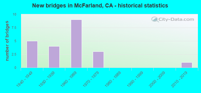
- New bridges - historical statistics
- 51940-1949
- 41950-1959
- 91960-1969
- 31970-1979
- 12010-2019

- Reconstructed bridges - Historical Statistics
- 11970-1979
- 21980-1989


- Bridge Condition - Deck
- 71.4%Good
- 7.1%Satisfactory
- 21.4%Poor

- Bridge Condition - Superstructure
- 92.9%Good
- 7.1%Poor

- Bridge Condition - Substructure
- 64.3%Good
- 21.4%Satisfactory
- 7.1%Fair
- 7.1%Poor

- Bridge Condition - Channel
- 62.5%Very good
- 12.5%Good
- 25.0%Satisfactory

- Bridge Condition - Culverts
- 50.0%Good
- 50.0%Satisfactory
Find on map >> Show street view
Structure Number: 50 0144, Location: 06-KER-099-46.32 (Lat: 35.630897, Lng: -119.215903), Route carried "on" structure: State highway 99, Year Built: 1950, Status: Open, Structure Length: 1.25m (4.10ft), Average Daily Traffic: 51,000 (year 2009), Truck Traffic: 27%, Average Future Daily Traffic: 116,492 (year 2042), Features Intersected: FRIANT-KERN CANAL
Minimum Vertical Clearance: 30+ m (98+ ft), Kilometerpoint: 46.320, Lanes on structure: 6, Base Highway Network: Yes (, Subroute: 1), Owner: State Highway Agency, Approaching Roadway Width: 40.5m (132.9ft), Skew: 31 degrees, Material/Design: Concrete continuous, Design/Construction: Culvert, Number Of Spans In Main Unit: 3, Length of Maximum Span: 4.0m (13.1ft), Curb-To-Curb Width: 34.0m (111.5ft), Out-to-Out Width: 62.0m (203.4ft)
Condition: Channel: Good, Culverts: Satisfactory, Operating Rating: 54.1 metric tons, Method Used To Determine Operating Rating: Field evaluation and documented engineering judgment, Inventory Rating: 32.4 metric tons, Method Used To Determine Inventory Rating: Field evaluation and documented engineering judgment, Structural Evaluation: Equal to present minimum criteria, Deck Geometry: Superior to present desirable criteria, Waterway Adequacy: Equal to present desirable criteria, Approach Roadway Alignment: Equal to present desirable criteria, Designated Inspection Frequency: Every 24 months, Inspection Date: March 2022
Find on map >> Show street view
Structure Number: 50 0207, Location: 06-KER-099-45.49 (Lat: 35.619103, Lng: -119.213094), Route carried "on" structure: State highway 99, Year Built: 1951, Year Reconstructed: 1970, Status: Open, Structure Length: 1.07m (3.51ft), Average Daily Traffic: 51,000 (year 2009), Truck Traffic: 27%, Average Future Daily Traffic: 116,492 (year 2042), Design Load: HS 20, Features Intersected: POSO CREEK OVERFLOW
Minimum Vertical Clearance: 30+ m (98+ ft), Kilometerpoint: 45.490, Lanes on structure: 6, Base Highway Network: Yes (, Subroute: 1), Owner: State Highway Agency, Approaching Roadway Width: 40.5m (132.9ft), Material/Design: Concrete continuous, Design/Construction: Culvert, Number Of Spans In Main Unit: 4, Length of Maximum Span: 2.7m (8.9ft), Curb-To-Curb Width: 40.5m (132.9ft), Out-to-Out Width: 47.0m (154.2ft)
Condition: Channel: Satisfactory, Culverts: Good, Operating Rating: 54.1 metric tons, Method Used To Determine Operating Rating: Field evaluation and documented engineering judgment, Inventory Rating: 32.4 metric tons, Method Used To Determine Inventory Rating: Field evaluation and documented engineering judgment, Structural Evaluation: Better than present minimum criteria, Deck Geometry: Superior to present desirable criteria, Waterway Adequacy: Equal to present minimum criteria, Approach Roadway Alignment: Equal to present desirable criteria, Designated Inspection Frequency: Every 24 months, Inspection Date: March 2022
Find on map >> Show street view
Structure Number: 50 022, Location: 06-KER-099-5.34 (Lat: 35.094614, Lng: -118.979972), Route carried "on" structure: County highway W254, Year Built: 1960, Status: Open, Structure Length: 9.59m (31.46ft), Average Daily Traffic: 2,683 (year 2017), Truck Traffic: 30%, Average Future Daily Traffic: 3,071 (year 2041), Design Load: HS 20, Features Intersected: STATE ROUTE 99, Facility Carried by Structure: DAVID ROAD
Minimum Vertical Clearance: 30+ m (98+ ft), Kilometerpoint: 0.000, Lanes on structure: 2, Lanes under structure: 7, Owner: State Highway Agency, Approaching Roadway Width: 12.2m (40.0ft), Skew: 3 degrees, Material/Design: Steel, Design/Construction: Stringer/Multi-beam, Number Of Spans In Main Unit: 2, Number Of Approach Spans: 2, Length of Maximum Span: 33.4m (109.6ft), Curb or Sidewalk Widths: Left: 1.5m (4.9ft), Right: 0.0m, Curb-To-Curb Width: 9.8m (32.2ft), Out-to-Out Width: 12.4m (40.7ft)
Condition: Deck: Good, Superstructure: Good, Substructure: Good, Operating Rating: 73.5 metric tons, Method Used To Determine Operating Rating: Load Factor (LF), Inventory Rating: 44.4 metric tons, Method Used To Determine Inventory Rating: Load Factor (LF), Structural Evaluation: Better than present minimum criteria, Deck Geometry: Meets minimum limits, Underclear: Better than present minimum criteria, Approach Roadway Alignment: Equal to present minimum criteria, Designated Inspection Frequency: Every 24 months, Other Special Inspection Frequency: Every 48 months, Inspection Date: December 2021, Other Special Inspection Date: March 2018, Deck Structure Type: Concrete Cast-file-Place, Wearing Surface/Protective System: Wearing Surface: Integral Concrete
Find on map >> Show street view
Structure Number: 50 0223, Location: 06-KER-099-49.30-MCF (Lat: 35.673128, Lng: -119.226683), Route carried "on" structure: City street , Year Built: 1963, Status: Open, Structure Length: 6.07m (19.91ft), Average Daily Traffic: 4,677 (year 2017), Truck Traffic: 5%, Average Future Daily Traffic: 8,671 (year 2042), Design Load: HS 20+Mod, Features Intersected: STATE ROUTE 99, Facility Carried by Structure: SHERWOOD AVE
Minimum Vertical Clearance: 30+ m (98+ ft), Kilometerpoint: 0.000, Lanes on structure: 2, Lanes under structure: 6, Owner: State Highway Agency, Approaching Roadway Width: 12.2m (40.0ft), Material/Design: Prestressed concrete continuous, Design/Construction: Stringer/Multi-beam, Number Of Spans In Main Unit: 2, Number Of Approach Spans: 2, Length of Maximum Span: 25.0m (82.0ft), Curb or Sidewalk Widths: Left: 1.5m (4.9ft), Right: 0.0m, Curb-To-Curb Width: 12.2m (40.0ft), Out-to-Out Width: 14.7m (48.2ft)
Condition: Deck: Good, Superstructure: Good, Substructure: Good, Operating Rating: 34.7 metric tons, Method Used To Determine Operating Rating: Load and Resistance Factor Rating (LRFR) rating reported by rating factor(RF) method using HL-93 loadings, Inventory Rating: 26.6 metric tons, Method Used To Determine Inventory Rating: Load and Resistance Factor Rating (LRFR) rating reported by rating factor(RF) method using HL-93 loadings, Structural Evaluation: Equal to present minimum criteria, Deck Geometry: Equal to present minimum criteria, Underclear: High priority of corrective action, Approach Roadway Alignment: Equal to present minimum criteria, Designated Inspection Frequency: Every 24 months, Inspection Date: March 2022, Deck Structure Type: Concrete Cast-file-Place
Find on map >> Show street view
Structure Number: 50 0225, Location: 06-KER-099-49.95-MCF (Lat: 35.682575, Lng: -119.229017), Route carried "on" structure: City street , Year Built: 1963, Status: Open, Structure Length: 7.22m (23.69ft), Average Daily Traffic: 440 (year 2007), Truck Traffic: 15%, Average Future Daily Traffic: 1,033 (year 2040), Design Load: HS 20+Mod, Features Intersected: STATE ROUTE 99, Facility Carried by Structure: PERKINS AVE
Minimum Vertical Clearance: 30+ m (98+ ft), Kilometerpoint: 0.000, Lanes on structure: 2, Lanes under structure: 6, Owner: State Highway Agency, Approaching Roadway Width: 12.2m (40.0ft), Material/Design: Prestressed concrete continuous, Design/Construction: Stringer/Multi-beam, Number Of Spans In Main Unit: 3, Number Of Approach Spans: 2, Length of Maximum Span: 18.0m (59.1ft), Curb or Sidewalk Widths: Left: 0.0m, Right: 1.5m (4.9ft), Curb-To-Curb Width: 12.2m (40.0ft), Out-to-Out Width: 14.7m (48.2ft)
Condition: Deck: Good, Superstructure: Good, Substructure: Fair, Operating Rating: 68.0 metric tons, Method Used To Determine Operating Rating: Load Factor (LF), Inventory Rating: 32.4 metric tons, Method Used To Determine Inventory Rating: Load Factor (LF), Structural Evaluation: Somewhat better than minimum adequacy, Deck Geometry: Equal to present desirable criteria, Underclear: High priority of corrective action, Approach Roadway Alignment: Equal to present minimum criteria, Designated Inspection Frequency: Every 24 months, Inspection Date: March 2022, Deck Structure Type: Concrete Cast-file-Place
Find on map >> Show street view
Structure Number: 50 0233, Location: 06-KER-099-50.41 (Lat: 35.689058, Lng: -119.230114), Route carried "on" structure: County highway , Year Built: 1963, Status: Open, Structure Length: 11.58m (37.99ft), Average Daily Traffic: 2,500 (year 2017), Truck Traffic: 15%, Average Future Daily Traffic: 5,000 (year 2040), Design Load: HS 20+Mod, Features Intersected: STATE ROUTE 99, Facility Carried by Structure: ELMO HWY
Minimum Vertical Clearance: 30+ m (98+ ft), Kilometerpoint: 0.000, Lanes on structure: 2, Lanes under structure: 5, Base Highway Network: Yes, Owner: State Highway Agency, Approaching Roadway Width: 12.2m (40.0ft), Skew: 9 degrees, Material/Design: Prestressed concrete continuous, Design/Construction: Stringer/Multi-beam, Number Of Spans In Main Unit: 4, Number Of Approach Spans: 2, Length of Maximum Span: 25.0m (82.0ft), Curb or Sidewalk Widths: Left: 0.0m, Right: 1.5m (4.9ft), Curb-To-Curb Width: 9.8m (32.2ft), Out-to-Out Width: 12.3m (40.4ft)
Condition: Deck: Good, Superstructure: Good, Substructure: Good, Operating Rating: 47.6 metric tons, Method Used To Determine Operating Rating: Load Factor (LF), Inventory Rating: 28.8 metric tons, Method Used To Determine Inventory Rating: Load Factor (LF), Structural Evaluation: Better than present minimum criteria, Deck Geometry: Meets minimum limits, Underclear: Somewhat better than minimum adequacy, Approach Roadway Alignment: Equal to present minimum criteria, Designated Inspection Frequency: Every 24 months, Inspection Date: March 2022, Deck Structure Type: Concrete Cast-file-Place
Find on map >> Show street view
Structure Number: 50 0237, Location: 06-KER-099-R47.37 (Lat: 35.645611, Lng: -119.220797), Route carried "on" structure: County highway , Year Built: 1970, Status: Open, Structure Length: 7.86m (25.79ft), Average Daily Traffic: 900 (year 2007), Truck Traffic: 20%, Average Future Daily Traffic: 1,122 (year 2040), Design Load: HS 20+Mod, Features Intersected: STATE ROUTE 99, Facility Carried by Structure: WHISLER ROAD
Minimum Vertical Clearance: 30+ m (98+ ft), Kilometerpoint: 0.000, Lanes on structure: 2, Lanes under structure: 6, Owner: State Highway Agency, Approaching Roadway Width: 12.2m (40.0ft), Skew: 1 degrees, Material/Design: Prestressed concrete continuous, Design/Construction: Stringer/Multi-beam, Number Of Spans In Main Unit: 2, Length of Maximum Span: 39.0m (128.0ft), Curb-To-Curb Width: 12.2m (40.0ft), Out-to-Out Width: 12.8m (42.0ft)
Condition: Deck: Satisfactory, Superstructure: Good, Substructure: Good, Operating Rating: 38.6 metric tons, Method Used To Determine Operating Rating: Load and Resistance Factor Rating (LRFR) rating reported by rating factor(RF) method using HL-93 loadings, Inventory Rating: 21.7 metric tons, Method Used To Determine Inventory Rating: Load and Resistance Factor Rating (LRFR) rating reported by rating factor(RF) method using HL-93 loadings, Structural Evaluation: Somewhat better than minimum adequacy, Deck Geometry: Equal to present desirable criteria, Underclear: Somewhat better than minimum adequacy, Approach Roadway Alignment: Better than present minimum criteria, Designated Inspection Frequency: Every 24 months, Inspection Date: March 2022, Deck Structure Type: Concrete Cast-file-Place
Find on map >> Show street view
Structure Number: 50C0034, Location: 0.1 MI W SAN JUAN ST (Lat: 35.673231, Lng: -119.225667), Route carried "on" structure: City street , Year Built: 1963, Status: Open, Structure Length: 3.63m (11.91ft), Average Daily Traffic: 3,060 (year 2002), Truck Traffic: 5%, Average Future Daily Traffic: 5,448 (year 2037), Design Load: HS 20+Mod, Features Intersected: UP RR, Facility Carried by Structure: SHERWOOD AVE
Minimum Vertical Clearance: 30+ m (98+ ft), Kilometerpoint: 0.000, Lanes on structure: 2, Owner: City or Municipal Highway Agency, Approaching Roadway Width: 12.3m (40.4ft), Material/Design: Prestressed concrete, Design/Construction: Slab, Number Of Spans In Main Unit: 2, Number Of Approach Spans: 1, Length of Maximum Span: 14.1m (46.3ft), Curb or Sidewalk Widths: Left: 1.5m (4.9ft), Right: 0.0m, Curb-To-Curb Width: 12.2m (40.0ft), Out-to-Out Width: 14.7m (48.2ft)
Condition: Deck: Good, Superstructure: Good, Substructure: Poor, Operating Rating: 63.5 metric tons, Method Used To Determine Operating Rating: Load Factor (LF), Inventory Rating: 32.4 metric tons, Method Used To Determine Inventory Rating: Load Factor (LF), Structural Evaluation: Meets minimum limits, Deck Geometry: Equal to present minimum criteria, Underclear: Better than present minimum criteria, Approach Roadway Alignment: Equal to present desirable criteria, Length Of Structure Improvement: 3.63m (11.91ft), Designated Inspection Frequency: Every 24 months, Inspection Date: March 2020, Bridge Improvement Cost: $534,000, Roadway Improvement Cost: $106,000, Total Project Cost: $897,000 ( Estimate for 2021), Deck Structure Type: Concrete Cast-file-Place, Wearing Surface/Protective System: Wearing Surface: Bituminous
Find on map >> Show street view
Structure Number: 50C0035, Location: 0.25 MI W BROWNING RD (Lat: 35.682711, Lng: -119.228031), Route carried "on" structure: City street , Year Built: 1963, Status: Open, Structure Length: 4.59m (15.06ft), Average Daily Traffic: 3,970 (year 2002), Truck Traffic: 5%, Average Future Daily Traffic: 7,067 (year 2037), Design Load: HS 20+Mod, Features Intersected: UP RR, Facility Carried by Structure: PERKINS AVE
Minimum Vertical Clearance: 30+ m (98+ ft), Kilometerpoint: 0.000, Lanes on structure: 2, Owner: City or Municipal Highway Agency, Approaching Roadway Width: 12.2m (40.0ft), Material/Design: Prestressed concrete continuous, Design/Construction: Stringer/Multi-beam, Number Of Spans In Main Unit: 1, Number Of Approach Spans: 2, Length of Maximum Span: 18.1m (59.4ft), Curb or Sidewalk Widths: Left: 0.0m, Right: 1.5m (4.9ft), Curb-To-Curb Width: 12.2m (40.0ft), Out-to-Out Width: 14.7m (48.2ft)
Condition: Deck: Poor, Superstructure: Good, Substructure: Satisfactory, Operating Rating: 34.0 metric tons, Method Used To Determine Operating Rating: Load and Resistance Factor Rating (LRFR) rating reported by rating factor(RF) method using HL-93 loadings, Inventory Rating: 21.7 metric tons, Method Used To Determine Inventory Rating: Load and Resistance Factor Rating (LRFR) rating reported by rating factor(RF) method using HL-93 loadings, Structural Evaluation: Somewhat better than minimum adequacy, Deck Geometry: Equal to present minimum criteria, Underclear: Better than present minimum criteria, Approach Roadway Alignment: Equal to present minimum criteria, Designated Inspection Frequency: Every 24 months, Inspection Date: March 2020, Deck Structure Type: Concrete Cast-file-Place
Find on map >> Show street view
Structure Number: 50C004, Location: 0.07 MI EAST OF SR 99 (Lat: 35.645614, Lng: -119.219353), Route carried "on" structure: County highway , Year Built: 1970, Status: Open, Structure Length: 4.29m (14.07ft), Average Daily Traffic: 450 (year 2002), Truck Traffic: 10%, Average Future Daily Traffic: 855 (year 2040), Design Load: HS 20+Mod, Features Intersected: UP RR, Facility Carried by Structure: WHISTLER RD
Minimum Vertical Clearance: 30+ m (98+ ft), Kilometerpoint: 0.000, Lanes on structure: 2, Owner: County Highway Agency, Approaching Roadway Width: 12.3m (40.4ft), Skew: 1 degrees, Material/Design: Prestressed concrete continuous, Design/Construction: Stringer/Multi-beam, Number Of Spans In Main Unit: 3, Length of Maximum Span: 14.6m (47.9ft), Curb-To-Curb Width: 12.2m (40.0ft), Out-to-Out Width: 12.8m (42.0ft)
Condition: Deck: Poor, Superstructure: Good, Substructure: Good, Operating Rating: 48.9 metric tons, Method Used To Determine Operating Rating: Load and Resistance Factor Rating (LRFR) rating reported by rating factor(RF) method using HL-93 loadings, Inventory Rating: 33.7 metric tons, Method Used To Determine Inventory Rating: Load and Resistance Factor Rating (LRFR) rating reported by rating factor(RF) method using HL-93 loadings, Structural Evaluation: Better than present minimum criteria, Deck Geometry: Equal to present desirable criteria, Underclear: Superior to present desirable criteria, Approach Roadway Alignment: Equal to present desirable criteria, Designated Inspection Frequency: Every 24 months, Inspection Date: November 2020, Deck Structure Type: Concrete Cast-file-Place
Find on map >> Show street view
Structure Number: 50C0118, Location: 2.9 MI E STATE HWY 43 (Lat: 35.645228, Lng: -119.279269), Route carried "on" structure: County highway , Year Built: 1958, Status: Open, Structure Length: 6.03m (19.78ft), Average Daily Traffic: 950 (year 2007), Truck Traffic: 10%, Average Future Daily Traffic: 1,171 (year 2037), Design Load: HS 20, Features Intersected: POSO CREEK, Facility Carried by Structure: WHISLER ROAD
Minimum Vertical Clearance: 30+ m (98+ ft), Kilometerpoint: 0.000, Lanes on structure: 2, Owner: County Highway Agency, Approaching Roadway Width: 7.3m (24.0ft), Skew: 3 degrees, Material/Design: Concrete continuous, Design/Construction: Slab, Number Of Spans In Main Unit: 8, Length of Maximum Span: 7.9m (25.9ft), Curb or Sidewalk Widths: Left: 0.4m (1.3ft), Right: 0.4m (1.3ft), Curb-To-Curb Width: 8.5m (27.9ft), Out-to-Out Width: 9.4m (30.8ft)
Condition: Deck: Poor, Superstructure: Poor, Substructure: Satisfactory, Channel: Satisfactory, Operating Rating: 42.1 metric tons, Method Used To Determine Operating Rating: Load Factor (LF), Inventory Rating: 25.3 metric tons, Method Used To Determine Inventory Rating: Load Factor (LF), Structural Evaluation: Meets minimum limits, Deck Geometry: Somewhat better than minimum adequacy, Waterway Adequacy: Better than present minimum criteria, Approach Roadway Alignment: Equal to present desirable criteria, Length Of Structure Improvement: 6.03m (19.78ft), Designated Inspection Frequency: Every 24 months, Inspection Date: March 2020, Bridge Improvement Cost: $1,304,000, Roadway Improvement Cost: $260,000, Total Project Cost: $2,190,000 ( Estimate for 2019), Deck Structure Type: Concrete Cast-file-Place
Find on map >> Show street view
Structure Number: 50C0119, Location: AT WHISLER RD (Lat: 35.644744, Lng: -119.204447), Route carried "on" structure: County highway , Year Built: 1949, Year Reconstructed: 1989, Status: Open, Structure Length: 3.42m (11.22ft), Average Daily Traffic: 600 (year 2007), Truck Traffic: 10%, Average Future Daily Traffic: 1,087 (year 2040), Design Load: HS 15, Features Intersected: FRIANT-KERN CANAL, Facility Carried by Structure: DRIVER ROAD
Minimum Vertical Clearance: 30+ m (98+ ft), Kilometerpoint: 0.000, Lanes on structure: 2, Owner: County Highway Agency, Approaching Roadway Width: 7.0m (23.0ft), Skew: 4 degrees, Material/Design: Concrete, Design/Construction: Tee Beam, Number Of Spans In Main Unit: 2, Length of Maximum Span: 17.1m (56.1ft), Curb-To-Curb Width: 12.2m (40.0ft), Out-to-Out Width: 13.3m (43.6ft)
Condition: Deck: Good, Superstructure: Good, Substructure: Good, Channel: Very good, Operating Rating: 17.8 metric tons, Method Used To Determine Operating Rating: Load and Resistance Factor Rating (LRFR) rating reported by rating factor(RF) method using HL-93 loadings, Inventory Rating: 13.6 metric tons, Method Used To Determine Inventory Rating: Load and Resistance Factor Rating (LRFR) rating reported by rating factor(RF) method using HL-93 loadings, Structural Evaluation: Meets minimum limits, Deck Geometry: Equal to present desirable criteria, Waterway Adequacy: Equal to present desirable criteria, Approach Roadway Alignment: Equal to present desirable criteria, Designated Inspection Frequency: Every 24 months, Inspection Date: November 2020, Deck Structure Type: Concrete Cast-file-Place, Wearing Surface/Protective System: Wearing Surface: Bituminous
Find on map >> Show street view
Structure Number: 50C0268, Location: 0.3 MI WEST OF ZACHARY AV (Lat: 35.703392, Lng: -119.191783), Route carried "on" structure: County highway , Year Built: 1949, Status: Open, Structure Length: 2.47m (8.10ft), Average Daily Traffic: 150 (year 2007), Truck Traffic: 10%, Average Future Daily Traffic: 212 (year 2037), Design Load: H 15, Features Intersected: FRIANT-KERN CANAL, Facility Carried by Structure: PETERSON RD
Minimum Vertical Clearance: 30+ m (98+ ft), Kilometerpoint: 0.000, Lanes on structure: 2, Owner: County Highway Agency, Approaching Roadway Width: 6.7m (22.0ft), Material/Design: Concrete, Design/Construction: Tee Beam, Number Of Spans In Main Unit: 2, Length of Maximum Span: 12.0m (39.4ft), Curb or Sidewalk Widths: Left: 0.4m (1.3ft), Right: 0.4m (1.3ft), Curb-To-Curb Width: 7.9m (25.9ft), Out-to-Out Width: 8.9m (29.2ft)
Condition: Deck: Good, Superstructure: Good, Substructure: Satisfactory, Channel: Very good, Operating Rating: 20.4 metric tons, Method Used To Determine Operating Rating: Load and Resistance Factor Rating (LRFR) rating reported by rating factor(RF) method using HL-93 loadings, Inventory Rating: 15.9 metric tons, Method Used To Determine Inventory Rating: Load and Resistance Factor Rating (LRFR) rating reported by rating factor(RF) method using HL-93 loadings, Structural Evaluation: Meets minimum limits, Deck Geometry: Somewhat better than minimum adequacy, Waterway Adequacy: Superior to present desirable criteria, Approach Roadway Alignment: Equal to present desirable criteria, Designated Inspection Frequency: Every 24 months, Inspection Date: March 2020, Deck Structure Type: Concrete Cast-file-Place, Wearing Surface/Protective System: Wearing Surface: Bituminous
Find on map >> Show street view
Structure Number: 50C0269, Location: 0.5 MI WEST OF ZACHARY AV (Lat: 35.689106, Lng: -119.195717), Route carried "on" structure: County highway , Year Built: 1949, Status: Open, Structure Length: 2.47m (8.10ft), Average Daily Traffic: 540 (year 2007), Truck Traffic: 10%, Average Future Daily Traffic: 612 (year 2037), Design Load: H 15, Features Intersected: FRIANT-KERN CANAL, Facility Carried by Structure: ELMO HIGHWAY
Minimum Vertical Clearance: 30+ m (98+ ft), Kilometerpoint: 0.000, Lanes on structure: 2, Owner: County Highway Agency, Approaching Roadway Width: 7.2m (23.6ft), Material/Design: Concrete, Design/Construction: Tee Beam, Number Of Spans In Main Unit: 2, Length of Maximum Span: 12.0m (39.4ft), Curb or Sidewalk Widths: Left: 0.4m (1.3ft), Right: 0.4m (1.3ft), Curb-To-Curb Width: 7.9m (25.9ft), Out-to-Out Width: 8.9m (29.2ft)
Condition: Deck: Good, Superstructure: Good, Substructure: Good, Channel: Very good, Operating Rating: 21.1 metric tons, Method Used To Determine Operating Rating: Load and Resistance Factor Rating (LRFR) rating reported by rating factor(RF) method using HL-93 loadings, Inventory Rating: 16.2 metric tons, Method Used To Determine Inventory Rating: Load and Resistance Factor Rating (LRFR) rating reported by rating factor(RF) method using HL-93 loadings, Structural Evaluation: Meets minimum limits, Deck Geometry: Somewhat better than minimum adequacy, Waterway Adequacy: Superior to present desirable criteria, Approach Roadway Alignment: Equal to present desirable criteria, Designated Inspection Frequency: Every 24 months, Inspection Date: March 2020, Deck Structure Type: Concrete Cast-file-Place, Wearing Surface/Protective System: Wearing Surface: Bituminous
Find on map >> Show street view
Structure Number: 50C027, Location: 0.5 MI WEST OF ZACHARY AV (Lat: 35.674533, Lng: -119.195706), Route carried "on" structure: County highway , Year Built: 1949, Status: Open, Structure Length: 2.47m (8.10ft), Average Daily Traffic: 640 (year 2007), Truck Traffic: 10%, Average Future Daily Traffic: 2,023 (year 2037), Design Load: H 15, Features Intersected: FRIANT-KERN CANAL, Facility Carried by Structure: SHERWOOD AVE
Minimum Vertical Clearance: 30+ m (98+ ft), Kilometerpoint: 0.000, Lanes on structure: 2, Owner: County Highway Agency, Approaching Roadway Width: 7.3m (24.0ft), Material/Design: Concrete, Design/Construction: Tee Beam, Number Of Spans In Main Unit: 2, Length of Maximum Span: 12.0m (39.4ft), Curb or Sidewalk Widths: Left: 0.4m (1.3ft), Right: 0.4m (1.3ft), Curb-To-Curb Width: 7.9m (25.9ft), Out-to-Out Width: 8.9m (29.2ft)
Condition: Deck: Good, Superstructure: Good, Substructure: Good, Channel: Very good, Operating Rating: 20.1 metric tons, Method Used To Determine Operating Rating: Load and Resistance Factor Rating (LRFR) rating reported by rating factor(RF) method using HL-93 loadings, Inventory Rating: 15.6 metric tons, Method Used To Determine Inventory Rating: Load and Resistance Factor Rating (LRFR) rating reported by rating factor(RF) method using HL-93 loadings, Structural Evaluation: Meets minimum limits, Deck Geometry: Somewhat better than minimum adequacy, Waterway Adequacy: Superior to present desirable criteria, Approach Roadway Alignment: Equal to present desirable criteria, Designated Inspection Frequency: Every 24 months, Inspection Date: March 2020, Deck Structure Type: Concrete Cast-file-Place, Wearing Surface/Protective System: Wearing Surface: Bituminous
Find on map >> Show street view
Structure Number: 50C0275, Location: 0.15 MI EAST OF DRIVER RD (Lat: 35.660036, Lng: -119.201842), Route carried "on" structure: County highway , Year Built: 1948, Year Reconstructed: 1989, Status: Open, Structure Length: 2.40m (7.87ft), Average Daily Traffic: 200 (year 2007), Truck Traffic: 10%, Average Future Daily Traffic: 212 (year 2037), Design Load: HS 15, Features Intersected: FRIANT-KERN CANAL, Facility Carried by Structure: HANAWALT AVE
Minimum Vertical Clearance: 30+ m (98+ ft), Kilometerpoint: 0.000, Lanes on structure: 2, Owner: County Highway Agency, Approaching Roadway Width: 6.5m (21.3ft), Material/Design: Concrete, Design/Construction: Tee Beam, Number Of Spans In Main Unit: 2, Length of Maximum Span: 12.0m (39.4ft), Curb-To-Curb Width: 12.2m (40.0ft), Out-to-Out Width: 13.3m (43.6ft)
Condition: Deck: Good, Superstructure: Good, Substructure: Good, Channel: Very good, Operating Rating: 31.8 metric tons, Method Used To Determine Operating Rating: Load Factor (LF), Inventory Rating: 19.1 metric tons, Method Used To Determine Inventory Rating: Load Factor (LF), Structural Evaluation: Somewhat better than minimum adequacy, Deck Geometry: Superior to present desirable criteria, Waterway Adequacy: Equal to present desirable criteria, Approach Roadway Alignment: Equal to present desirable criteria, Designated Inspection Frequency: Every 24 months, Inspection Date: March 2020, Deck Structure Type: Concrete Cast-file-Place
Find on map >> Show street view
Structure Number: 50 0223, Location: 06-KER-099-49.30-MCF (Lat: 35.673128, Lng: -119.226683), Route carried "under" structure: State highway 99, Year Built: 1963, Structure Length: 0. m, Average Daily Traffic: 49,000 (year 2009), Truck Traffic: 29%, Features Intersected: STATE ROUTE 99, Facility Carried by Structure: SHERWOOD AVE
Minimum Vertical Clearance: 4.54m (14.90ft), Kilometerpoint: 49.300, Lanes on structure: 2, Lanes under structure: 6, Material/Design: Prestressed concrete continuous, Design/Construction: Stringer/Multi-beam, Length of Maximum Span: 25.0m (82.0ft)
Find on map >> Show street view
Structure Number: 50 0224, Location: 06-KER-099-49.66-MCF (Lat: 35.678314, Lng: -119.227817), Route carried "under" structure: State highway 99, Year Built: 1959, Structure Length: 0. m, Average Daily Traffic: 49,000 (year 2009), Truck Traffic: 29%, Features Intersected: STATE ROUTE 99, Facility Carried by Structure: PEDESTRIAN WALKWAY
Minimum Vertical Clearance: 4.95m (16.24ft), Kilometerpoint: 49.660, Lanes under structure: 6, Material/Design: Steel continuous, Design/Construction: Girder and Floorbeam System, Length of Maximum Span: 29.6m (97.1ft)
Find on map >> Show street view
Structure Number: 50 0225, Location: 06-KER-099-49.95-MCF (Lat: 35.682575, Lng: -119.229017), Route carried "under" structure: State highway 99, Year Built: 1963, Structure Length: 0. m, Average Daily Traffic: 49,000 (year 2009), Truck Traffic: 29%, Features Intersected: STATE ROUTE 99, Facility Carried by Structure: PERKINS AVE
Minimum Vertical Clearance: 5.00m (16.40ft), Kilometerpoint: 49.950, Lanes on structure: 2, Lanes under structure: 6, Material/Design: Prestressed concrete continuous, Design/Construction: Stringer/Multi-beam, Length of Maximum Span: 18.0m (59.1ft)
Find on map >> Show street view
Structure Number: 50 0233, Location: 06-KER-099-50.41 (Lat: 35.689058, Lng: -119.230114), Route carried "under" structure: State highway 99, Year Built: 1963, Structure Length: 0. m, Average Daily Traffic: 49,000 (year 2009), Truck Traffic: 29%, Features Intersected: STATE ROUTE 99, Facility Carried by Structure: ELMO HWY
Minimum Vertical Clearance: 6.78m (22.24ft), Kilometerpoint: 50.410, Lanes on structure: 2, Lanes under structure: 5, Material/Design: Prestressed concrete continuous, Design/Construction: Stringer/Multi-beam, Length of Maximum Span: 25.0m (82.0ft)
Find on map >> Show street view
Structure Number: 50 0237, Location: 06-KER-099-R47.37 (Lat: 35.645611, Lng: -119.220797), Route carried "under" structure: State highway 99, Year Built: 1970, Structure Length: 0. m, Average Daily Traffic: 51,000 (year 2009), Truck Traffic: 27%, Features Intersected: STATE ROUTE 99, Facility Carried by Structure: WHISLER ROAD
Minimum Vertical Clearance: 4.74m (15.55ft), Kilometerpoint: 47.370, Lanes on structure: 2, Lanes under structure: 6, Material/Design: Prestressed concrete continuous, Design/Construction: Stringer/Multi-beam, Length of Maximum Span: 39.0m (128.0ft)
Find on map >> Show street view
Structure Number: 50 0518, Location: 06-KER-099-49.62-MCF (Lat: 35.678000, Lng: -119.227111), Route carried "under" structure: State highway 99, Year Built: 2017, Structure Length: 0. m, Average Daily Traffic: 60,500 (year 2017), Truck Traffic: 29%, Features Intersected: STATE ROUTE 99, NB RAMP, Facility Carried by Structure: PEDESTRIAN WALKWAY
Minimum Vertical Clearance: 5.69m (18.67ft), Kilometerpoint: 49.620, Lanes under structure: 6, Material/Design: Concrete continuous, Design/Construction: Box Beam or Girders - Single/Spread, Length of Maximum Span: 35.4m (116.1ft)