Bridge Statistics for Matteson, Illinois (IL)
Condition, Traffic, Stress, Structural Evaluation, Project Costs
- National Bridge Inventory (NBI) Statistics
- 27Number of bridges
- 138ft / 41.8mTotal length
- $4,915,000Total costs
- 663,025Total average daily traffic
- 68,521Total average daily truck traffic
- National Bridge Inventory (NBI) Registered Bridges for Matteson
- No street view available for this location
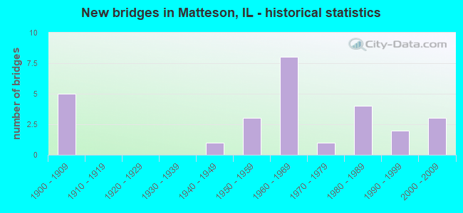
- New bridges - historical statistics
- 51900-1909
- 11940-1949
- 31950-1959
- 81960-1969
- 11970-1979
- 41980-1989
- 21990-1999
- 32000-2009

- Reconstructed bridges - Historical Statistics
- 11960-1969
- 01970-1979
- 01980-1989
- 11990-1999
- 12000-2009


- Bridge Condition - Deck
- 12.5%Very good
- 25.0%Good
- 50.0%Satisfactory
- 12.5%Poor

- Bridge Condition - Superstructure
- 12.5%Very good
- 37.5%Satisfactory
- 12.5%Fair
- 37.5%Serious

- Bridge Condition - Substructure
- 25.0%Very good
- 50.0%Good
- 12.5%Satisfactory
- 12.5%Fair

- Bridge Condition - Channel
- 6.3%Very good
- 12.5%Good
- 37.5%Satisfactory
- 43.8%Fair

- Bridge Condition - Culverts
- 8.3%Very good
- 25.0%Good
- 41.7%Satisfactory
- 25.0%Fair
Find on map >> Show street view
Structure Number: 55, Location: 2.5 N TIMEWELL (Lat: 40.047025, Lng: -90.881822), Route carried "on" structure: County highway , Year Built: 1959, Status: Open, Structure Length: 0.70m (2.30ft), Average Daily Traffic: 100 (year 2014), Truck Traffic: 19%, Average Future Daily Traffic: 125 (year 2032), Design Load: H 15, Features Intersected: LITTLE MISSOURI CR, Facility Carried by Structure: FAS 1582
Minimum Vertical Clearance: 30+ m (98+ ft), Kilometerpoint: 4.908, Lanes on structure: 2, Owner: County Highway Agency, Approaching Roadway Width: 6.4m (21.0ft), Material/Design: Concrete continuous, Design/Construction: Culvert, Number Of Spans In Main Unit: 2, Length of Maximum Span: 3.0m (9.8ft)
Condition: Channel: Fair, Culverts: Fair, Operating Rating: 89.1 metric tons, Method Used To Determine Operating Rating: Load Factor (LF) rating reported by rating factor (RF) method using MS18 loading, Inventory Rating: 89.1 metric tons, Method Used To Determine Inventory Rating: Load Factor (LF) rating reported by rating factor (RF) method using MS18 loading, Structural Evaluation: Somewhat better than minimum adequacy, Waterway Adequacy: Better than present minimum criteria, Approach Roadway Alignment: Equal to present minimum criteria, Designated Inspection Frequency: Every 24 months, Inspection Date: October 2021
Find on map >> Show street view
Structure Number: 72, Location: 2 M S OF BELLEVIEW (Lat: 39.325389, Lng: -90.766692), Route carried "on" structure: State highway 96, Year Built: 1941, Status: Posted for load, Structure Length: 0.79m (2.59ft), Average Daily Traffic: 575 (year 2021), Truck Traffic: 24%, Average Future Daily Traffic: 670 (year 2032), Design Load: H 15, Features Intersected: INFIDEL HOLLOW CREEK
Minimum Vertical Clearance: 30+ m (98+ ft), Kilometerpoint: 16.994, Lanes on structure: 2, Base Highway Network: Yes, Owner: State Highway Agency, Approaching Roadway Width: 8.2m (26.9ft), Material/Design: Concrete continuous, Design/Construction: Culvert, Number Of Spans In Main Unit: 2, Length of Maximum Span: 3.7m (12.1ft)
Condition: Channel: Satisfactory, Culverts: Good, Operating Rating: 26.9 metric tons, Method Used To Determine Operating Rating: Load Factor (LF) rating reported by rating factor (RF) method using MS18 loading, Inventory Rating: 16.2 metric tons, Method Used To Determine Inventory Rating: Load Factor (LF) rating reported by rating factor (RF) method using MS18 loading, Structural Evaluation: Meets minimum limits, Waterway Adequacy: Equal to present minimum criteria, Approach Roadway Alignment: Equal to present desirable criteria, Bridge Posting: Required (Relationship of Operating Rating to Maximum Legal Load: > 39.9% below), Length Of Structure Improvement: 0.79m (2.59ft), Designated Inspection Frequency: Every 12 months, Inspection Date: June 2021, Bridge Improvement Cost: $105,000, Roadway Improvement Cost: $5,000, Total Project Cost: $110,000
Find on map >> Show street view
Structure Number: 16005, Location: 0.5 M S US 30 (Lat: 41.499133, Lng: -87.742533), Route carried "on" structure: Interstate 57, Year Built: 1966, Status: Open, Structure Length: 4.45m (14.60ft), Average Daily Traffic: 33,000 (year 2021), Truck Traffic: 17%, Average Future Daily Traffic: 20,806 (year 2032), Design Load: HS 20+Mod, Features Intersected: ABANDONED RR
Minimum Vertical Clearance: 30+ m (98+ ft), Kilometerpoint: 547.532, Lanes on structure: 2, Base Highway Network: Yes, Owner: State Highway Agency, Approaching Roadway Width: 12.8m (42.0ft), Material/Design: Prestressed concrete continuous, Design/Construction: Stringer/Multi-beam, Number Of Spans In Main Unit: 3, Length of Maximum Span: 15.0m (49.2ft), Curb-To-Curb Width: 11.8m (38.7ft), Out-to-Out Width: 12.8m (42.0ft)
Condition: Deck: Satisfactory, Superstructure: Satisfactory, Substructure: Good, Operating Rating: 89.1 metric tons, Method Used To Determine Operating Rating: Load Factor (LF) rating reported by rating factor (RF) method using MS18 loading, Inventory Rating: 60.3 metric tons, Method Used To Determine Inventory Rating: Load Factor (LF) rating reported by rating factor (RF) method using MS18 loading, Structural Evaluation: Equal to present minimum criteria, Deck Geometry: Equal to present minimum criteria, Approach Roadway Alignment: Equal to present desirable criteria, Designated Inspection Frequency: Every 24 months, Inspection Date: November 2021, Deck Structure Type: Concrete Cast-file-Place, Wearing Surface/Protective System: Wearing Surface: Other, Deck Protection: Epoxy Coated Reinforcing
Find on map >> Show street view
Structure Number: 160051, Location: 0.5 M S US 30 (Lat: 41.498989, Lng: -87.742544), Route carried "on" structure: Interstate 57, Year Built: 1966, Year Reconstructed: 1996, Status: Open, Structure Length: 4.45m (14.60ft), Average Daily Traffic: 33,000 (year 2021), Truck Traffic: 17%, Average Future Daily Traffic: 20,806 (year 2032), Design Load: HS 20+Mod, Features Intersected: ABANDONED RR
Minimum Vertical Clearance: 30+ m (98+ ft), Kilometerpoint: 547.516, Lanes on structure: 2, Base Highway Network: Yes, Owner: State Highway Agency, Approaching Roadway Width: 12.8m (42.0ft), Material/Design: Prestressed concrete continuous, Design/Construction: Stringer/Multi-beam, Number Of Spans In Main Unit: 3, Length of Maximum Span: 15.0m (49.2ft), Curb-To-Curb Width: 11.8m (38.7ft), Out-to-Out Width: 12.8m (42.0ft)
Condition: Deck: Satisfactory, Superstructure: Satisfactory, Substructure: Good, Operating Rating: 89.1 metric tons, Method Used To Determine Operating Rating: Load Factor (LF) rating reported by rating factor (RF) method using MS18 loading, Inventory Rating: 60.3 metric tons, Method Used To Determine Inventory Rating: Load Factor (LF) rating reported by rating factor (RF) method using MS18 loading, Structural Evaluation: Equal to present minimum criteria, Deck Geometry: Equal to present minimum criteria, Approach Roadway Alignment: Equal to present desirable criteria, Designated Inspection Frequency: Every 24 months, Inspection Date: November 2021, Deck Structure Type: Concrete Cast-file-Place, Wearing Surface/Protective System: Wearing Surface: Other, Deck Protection: Epoxy Coated Reinforcing
Find on map >> Show street view
Structure Number: 160286, Location: 1.7 M W I-57 (Lat: 41.506147, Lng: -87.776461), Route carried "on" structure: US 30, Year Built: 1954, Year Reconstructed: 1968, Status: Open, Structure Length: 0.85m (2.79ft), Average Daily Traffic: 15,300 (year 2021), Truck Traffic: 5%, Average Future Daily Traffic: 17,304 (year 2032), Design Load: HS 20, Features Intersected: BUTTERFIELD CREEK
Minimum Vertical Clearance: 30+ m (98+ ft), Kilometerpoint: 224.015, Lanes on structure: 4, Base Highway Network: Yes, Owner: State Highway Agency, Approaching Roadway Width: 20.1m (65.9ft), Skew: 31 degrees, Material/Design: Concrete, Design/Construction: Slab, Number Of Spans In Main Unit: 1, Length of Maximum Span: 8.2m (26.9ft), Curb-To-Curb Width: 21.3m (69.9ft), Out-to-Out Width: 26.4m (86.6ft)
Condition: Deck: Satisfactory, Superstructure: Satisfactory, Substructure: Satisfactory, Channel: Satisfactory, Operating Rating: 69.0 metric tons, Method Used To Determine Operating Rating: Load Factor (LF) rating reported by rating factor (RF) method using MS18 loading, Inventory Rating: 41.1 metric tons, Method Used To Determine Inventory Rating: Load Factor (LF) rating reported by rating factor (RF) method using MS18 loading, Structural Evaluation: Equal to present minimum criteria, Deck Geometry: Superior to present desirable criteria, Waterway Adequacy: Equal to present minimum criteria, Approach Roadway Alignment: Equal to present desirable criteria, Designated Inspection Frequency: Every 24 months, Inspection Date: May 2020, Deck Structure Type: Concrete Cast-file-Place, Wearing Surface/Protective System: Wearing Surface: Latex Concrete
Find on map >> Show street view
Structure Number: 161098, Location: 1.5 M N US 30 (Lat: 41.527969, Lng: -87.743222), Route carried "on" structure: Other road , Year Built: 1967, Year Reconstructed: 2000, Status: Open, Structure Length: 7.96m (26.12ft), Average Daily Traffic: 15,800 (year 2018), Truck Traffic: 2%, Average Future Daily Traffic: 17,510 (year 2032), Design Load: HS 20, Features Intersected: I- 57, Facility Carried by Structure: VOLLMER RD
Minimum Vertical Clearance: 30+ m (98+ ft), Kilometerpoint: 3.830, Lanes on structure: 6, Lanes under structure: 6, Base Highway Network: Yes, Owner: State Highway Agency, Approaching Roadway Width: 23.0m (75.5ft), Skew: 30 degrees, Material/Design: Steel continuous, Design/Construction: Stringer/Multi-beam, Number Of Spans In Main Unit: 2, Number Of Approach Spans: 2, Length of Maximum Span: 31.1m (102.0ft), Curb-To-Curb Width: 23.0m (75.5ft), Out-to-Out Width: 28.6m (93.8ft)
Condition: Deck: Good, Superstructure: Serious, Substructure: Fair, Operating Rating: 87.5 metric tons, Method Used To Determine Operating Rating: Load Factor (LF) rating reported by rating factor (RF) method using MS18 loading, Inventory Rating: 50.5 metric tons, Method Used To Determine Inventory Rating: Load Factor (LF) rating reported by rating factor (RF) method using MS18 loading, Structural Evaluation: High priority of corrective action, Deck Geometry: Meets minimum limits, Underclear: Somewhat better than minimum adequacy, Approach Roadway Alignment: Equal to present desirable criteria, Length Of Structure Improvement: 9.27m (30.41ft), Designated Inspection Frequency: Every 12 months, Inspection Date: Febuary 2021, Bridge Improvement Cost: $3,170,000, Roadway Improvement Cost: $317,000, Total Project Cost: $4,755,000, Deck Structure Type: Concrete Cast-file-Place, Wearing Surface/Protective System: Deck Protection: Epoxy Coated Reinforcing
Find on map >> Show street view
Structure Number: 16229, Location: 0.04 M N of V Common (Lat: 41.517133, Lng: -87.742356), Route carried "on" structure: Interstate 57, Year Built: 1967, Status: Open, Structure Length: 1.13m (3.71ft), Average Daily Traffic: 86,800 (year 2021), Truck Traffic: 14%, Average Future Daily Traffic: 141,500 (year 2037), Design Load: HS 20, Features Intersected: BUTTERFIELD CREEK
Minimum Vertical Clearance: 30+ m (98+ ft), Kilometerpoint: 549.447, Lanes on structure: 4, Base Highway Network: Yes, Owner: State Highway Agency, Approaching Roadway Width: 14.6m (47.9ft), Skew: 30 degrees, Material/Design: Concrete continuous, Design/Construction: Culvert, Number Of Spans In Main Unit: 2, Length of Maximum Span: 0.0m
Condition: Channel: Good, Culverts: Satisfactory, Operating Rating: 63.5 metric tons, Method Used To Determine Operating Rating: Load Factor (LF) rating reported by rating factor (RF) method using MS18 loading, Inventory Rating: 37.9 metric tons, Method Used To Determine Inventory Rating: Load Factor (LF) rating reported by rating factor (RF) method using MS18 loading, Structural Evaluation: Equal to present minimum criteria, Waterway Adequacy: Equal to present minimum criteria, Approach Roadway Alignment: Equal to present desirable criteria, Designated Inspection Frequency: Every 24 months, Inspection Date: Febuary 2021
Find on map >> Show street view
Structure Number: 162505, Location: 0.05 M S US 30 (Lat: 41.505372, Lng: -87.713133), Route carried "on" structure: Other road , Year Built: 1985, Status: Open, Structure Length: 0.90m (2.95ft), Average Daily Traffic: 18,100 (year 2021), Truck Traffic: 2%, Average Future Daily Traffic: 19,158 (year 2032), Design Load: HS 20, Features Intersected: BUTTERFIELD CREEK, Facility Carried by Structure: GOVERNORS HWY-PULA
Minimum Vertical Clearance: 30+ m (98+ ft), Kilometerpoint: 24.075, Lanes on structure: 5, Base Highway Network: Yes, Owner: State Highway Agency, Approaching Roadway Width: 20.7m (67.9ft), Skew: 20 degrees, Material/Design: Concrete continuous, Design/Construction: Culvert, Number Of Spans In Main Unit: 3, Length of Maximum Span: 2.9m (9.5ft), Curb or Sidewalk Widths: Left: 1.5m (4.9ft), Right: 1.5m (4.9ft)
Condition: Channel: Good, Culverts: Good, Operating Rating: 89.1 metric tons, Method Used To Determine Operating Rating: Load Factor (LF) rating reported by rating factor (RF) method using MS18 loading, Inventory Rating: 89.1 metric tons, Method Used To Determine Inventory Rating: Load Factor (LF) rating reported by rating factor (RF) method using MS18 loading, Structural Evaluation: Better than present minimum criteria, Waterway Adequacy: Equal to present desirable criteria, Approach Roadway Alignment: Equal to present desirable criteria, Designated Inspection Frequency: Every 48 months, Inspection Date: January 2020, Deck Structure Type: Other
Find on map >> Show street view
Structure Number: 162522, Location: 0.6 M E OF IL 50 (Lat: 41.506033, Lng: -87.720669), Route carried "on" structure: US 30, Year Built: 1983, Status: Open, Structure Length: 1.36m (4.46ft), Average Daily Traffic: 38,100 (year 2021), Truck Traffic: 5%, Average Future Daily Traffic: 38,831 (year 2032), Design Load: HS 20, Features Intersected: BUTTERFIELD CREEK
Minimum Vertical Clearance: 30+ m (98+ ft), Kilometerpoint: 228.649, Lanes on structure: 6, Base Highway Network: Yes, Owner: State Highway Agency, Approaching Roadway Width: 28.0m (91.9ft), Skew: 23 degrees, Material/Design: Concrete continuous, Design/Construction: Culvert, Number Of Spans In Main Unit: 3, Length of Maximum Span: 4.5m (14.8ft), Curb or Sidewalk Widths: Left: 2.1m (6.9ft), Right: 2.1m (6.9ft)
Condition: Channel: Satisfactory, Culverts: Satisfactory, Operating Rating: 80.0 metric tons, Method Used To Determine Operating Rating: Load Factor (LF) rating reported by rating factor (RF) method using MS18 loading, Inventory Rating: 47.6 metric tons, Method Used To Determine Inventory Rating: Load Factor (LF) rating reported by rating factor (RF) method using MS18 loading, Structural Evaluation: Equal to present minimum criteria, Waterway Adequacy: Equal to present desirable criteria, Approach Roadway Alignment: Equal to present desirable criteria, Designated Inspection Frequency: Every 24 months, Inspection Date: Febuary 2022, Deck Structure Type: Other
Find on map >> Show street view
Structure Number: 162531, Location: 0.1 M W CRAWFORD AVE (Lat: 41.506019, Lng: -87.715272), Route carried "on" structure: US 30, Year Built: 1985, Status: Open, Structure Length: 0.90m (2.95ft), Average Daily Traffic: 38,100 (year 2021), Truck Traffic: 5%, Average Future Daily Traffic: 38,831 (year 2032), Design Load: HS 20, Features Intersected: BUTTERFIELD CREEK
Minimum Vertical Clearance: 30+ m (98+ ft), Kilometerpoint: 229.100, Lanes on structure: 7, Base Highway Network: Yes, Owner: State Highway Agency, Approaching Roadway Width: 15.2m (49.9ft), Skew: 20 degrees, Material/Design: Concrete continuous, Design/Construction: Culvert, Number Of Spans In Main Unit: 3, Length of Maximum Span: 3.0m (9.8ft), Curb or Sidewalk Widths: Left: 0.0m, Right: 1.5m (4.9ft)
Condition: Channel: Satisfactory, Culverts: Satisfactory, Operating Rating: 79.4 metric tons, Method Used To Determine Operating Rating: Load Factor (LF) rating reported by rating factor (RF) method using MS18 loading, Inventory Rating: 47.6 metric tons, Method Used To Determine Inventory Rating: Load Factor (LF) rating reported by rating factor (RF) method using MS18 loading, Structural Evaluation: Equal to present minimum criteria, Waterway Adequacy: Equal to present desirable criteria, Approach Roadway Alignment: Equal to present desirable criteria, Designated Inspection Frequency: Every 24 months, Inspection Date: Febuary 2022, Deck Structure Type: Other
Find on map >> Show street view
Structure Number: 162538, Location: 0.3 M N OF US 30 (Lat: 41.510394, Lng: -87.713192), Route carried "on" structure: Other road , Year Built: 1986, Status: Open, Structure Length: 1.09m (3.58ft), Average Daily Traffic: 12,500 (year 2021), Truck Traffic: 3%, Average Future Daily Traffic: 12,463 (year 2032), Design Load: HS 20, Features Intersected: BUTTERFIELD CREEK, Facility Carried by Structure: CRAWFORD AVE
Minimum Vertical Clearance: 30+ m (98+ ft), Kilometerpoint: 23.512, Lanes on structure: 2, Base Highway Network: Yes, Owner: State Highway Agency, Approaching Roadway Width: 10.1m (33.1ft), Skew: 1 degrees, Material/Design: Concrete continuous, Design/Construction: Culvert, Number Of Spans In Main Unit: 3, Length of Maximum Span: 3.7m (12.1ft)
Condition: Channel: Fair, Culverts: Good, Operating Rating: 61.2 metric tons, Method Used To Determine Operating Rating: Load Factor (LF) rating reported by rating factor (RF) method using MS18 loading, Inventory Rating: 36.9 metric tons, Method Used To Determine Inventory Rating: Load Factor (LF) rating reported by rating factor (RF) method using MS18 loading, Structural Evaluation: Better than present minimum criteria, Waterway Adequacy: Equal to present desirable criteria, Approach Roadway Alignment: Equal to present desirable criteria, Designated Inspection Frequency: Every 48 months, Inspection Date: January 2019
Find on map >> Show street view
Structure Number: 162783, Location: 0.5 M S VOLLMER RD (Lat: 41.523722, Lng: -87.732628), Route carried "on" structure: State highway 50, Year Built: 2003, Status: Open, Structure Length: 0.89m (2.92ft), Average Daily Traffic: 17,200 (year 2021), Truck Traffic: 2%, Average Future Daily Traffic: 17,510 (year 2032), Design Load: HS 20+Mod, Features Intersected: BUTTERFIELD CREEK
Minimum Vertical Clearance: 30+ m (98+ ft), Kilometerpoint: 50.017, Lanes on structure: 4, Base Highway Network: Yes, Owner: State Highway Agency, Approaching Roadway Width: 14.6m (47.9ft), Skew: 21 degrees, Material/Design: Concrete, Design/Construction: Culvert, Number Of Spans In Main Unit: 2, Length of Maximum Span: 3.9m (12.8ft)
Condition: Channel: Satisfactory, Culverts: Satisfactory, Operating Rating: 44.1 metric tons, Method Used To Determine Operating Rating: Load Factor (LF) rating reported by rating factor (RF) method using MS18 loading, Inventory Rating: 32.4 metric tons, Method Used To Determine Inventory Rating: Load Factor (LF) rating reported by rating factor (RF) method using MS18 loading, Structural Evaluation: Equal to present minimum criteria, Waterway Adequacy: Superior to present desirable criteria, Approach Roadway Alignment: Equal to present desirable criteria, Designated Inspection Frequency: Every 24 months, Inspection Date: July 2020
Find on map >> Show street view
Structure Number: 163027, Location: 0.25 M N US 30 P21 (Lat: 41.509358, Lng: -87.771008), Route carried "on" structure: Other road , Year Built: 1957, Status: Open, Structure Length: 0.63m (2.07ft), Average Daily Traffic: 5,150 (year 2018), Truck Traffic: 3%, Average Future Daily Traffic: 5,562 (year 2032), Design Load: H 20, Features Intersected: BUTTERFIELD CREEK, Facility Carried by Structure: RIDGELAND AVE
Minimum Vertical Clearance: 30+ m (98+ ft), Kilometerpoint: 5.472, Lanes on structure: 2, Owner: County Highway Agency, Approaching Roadway Width: 9.1m (29.9ft), Material/Design: Concrete, Design/Construction: Culvert, Number Of Spans In Main Unit: 2, Length of Maximum Span: 3.4m (11.2ft)
Condition: Channel: Fair, Culverts: Fair, Operating Rating: 62.9 metric tons, Method Used To Determine Operating Rating: Load Factor (LF) rating reported by rating factor (RF) method using MS18 loading, Inventory Rating: 37.9 metric tons, Method Used To Determine Inventory Rating: Load Factor (LF) rating reported by rating factor (RF) method using MS18 loading, Structural Evaluation: Somewhat better than minimum adequacy, Waterway Adequacy: Equal to present minimum criteria, Approach Roadway Alignment: Equal to present desirable criteria, Length Of Structure Improvement: 1.34m (4.40ft), Designated Inspection Frequency: Every 24 months, Inspection Date: August 2021, Bridge Improvement Cost: $33,000, Roadway Improvement Cost: $3,000, Total Project Cost: $50,000, Deck Structure Type: Other
Find on map >> Show street view
Structure Number: 163276, Location: .35M E IL43 (Lat: 41.528053, Lng: -87.783156), Route carried "on" structure: Other road , Year Built: 2003, Status: Open, Structure Length: 0.66m (2.17ft), Average Daily Traffic: 11,100 (year 2018), Truck Traffic: 3%, Average Future Daily Traffic: 11,021 (year 2032), Design Load: HS 20, Features Intersected: TRIB FLOSSMOOR DITCH, Facility Carried by Structure: VOLLMER RD
Minimum Vertical Clearance: 30+ m (98+ ft), Kilometerpoint: 0.563, Lanes on structure: 4, Base Highway Network: Yes, Owner: County Highway Agency, Approaching Roadway Width: 16.2m (53.1ft), Skew: 23 degrees, Material/Design: Concrete, Design/Construction: Culvert, Number Of Spans In Main Unit: 2, Length of Maximum Span: 3.2m (10.5ft)
Condition: Channel: Fair, Culverts: Very good, Operating Rating: 44.1 metric tons, Method Used To Determine Operating Rating: Assigned rating based on Load Factor Design (LFD) reported by rating factor (RF) using MS18 loading, Inventory Rating: 32.4 metric tons, Method Used To Determine Inventory Rating: Assigned rating based on Load Factor Design (LFD) reported by rating factor (RF) using MS18 loading, Structural Evaluation: Equal to present desirable criteria, Waterway Adequacy: Equal to present desirable criteria, Approach Roadway Alignment: Equal to present desirable criteria, Designated Inspection Frequency: Every 48 months, Inspection Date: June 2020
Find on map >> Show street view
Structure Number: 165, Location: 0.66 M S US 30 P21 (Lat: 41.496661, Lng: -87.790311), Route carried "on" structure: Other road , Year Built: 1900, Status: Open, Structure Length: 0.79m (2.59ft), Average Daily Traffic: 10,500 (year 2021), Truck Traffic: 3%, Average Future Daily Traffic: 10,918 (year 2032), Features Intersected: HICKORY CR, Facility Carried by Structure: HARLEM AVE
Minimum Vertical Clearance: 30+ m (98+ ft), Kilometerpoint: 1.062, Lanes on structure: 2, Owner: County Highway Agency, Approaching Roadway Width: 8.2m (26.9ft), Skew: 1 degrees, Material/Design: Concrete continuous, Design/Construction: Culvert, Number Of Spans In Main Unit: 3, Length of Maximum Span: 2.7m (8.9ft)
Condition: Channel: Fair, Culverts: Fair, Operating Rating: 57.3 metric tons, Method Used To Determine Operating Rating: Load Factor (LF) rating reported by rating factor (RF) method using MS18 loading, Inventory Rating: 34.7 metric tons, Method Used To Determine Inventory Rating: Load Factor (LF) rating reported by rating factor (RF) method using MS18 loading, Structural Evaluation: Somewhat better than minimum adequacy, Waterway Adequacy: Equal to present desirable criteria, Approach Roadway Alignment: Equal to present desirable criteria, Designated Inspection Frequency: Every 24 months, Inspection Date: August 2021
Find on map >> Show street view
Structure Number: 167445, Location: 1.4 M E I57 P21 (Lat: 41.513425, Lng: -87.716722), Route carried "on" structure: City street , Year Built: 1964, Status: Posted for load, Structure Length: 0.91m (2.99ft), Average Daily Traffic: 3,050 (year 2018), Truck Traffic: 5%, Average Future Daily Traffic: 400 (year 2032), Features Intersected: BUTTERFIELD CR, Facility Carried by Structure: 207TH STREET
Minimum Vertical Clearance: 30+ m (98+ ft), Kilometerpoint: 2.108, Lanes on structure: 2, Owner: City or Municipal Highway Agency, Approaching Roadway Width: 12.4m (40.7ft), Material/Design: Concrete, Design/Construction: Channel Beam, Number Of Spans In Main Unit: 1, Length of Maximum Span: 8.5m (27.9ft), Curb or Sidewalk Widths: Left: 1.5m (4.9ft), Right: 1.5m (4.9ft), Curb-To-Curb Width: 12.4m (40.7ft), Out-to-Out Width: 16.1m (52.8ft)
Condition: Deck: Poor, Superstructure: Serious, Substructure: Good, Channel: Fair, Operating Rating: 43.1 metric tons, Method Used To Determine Operating Rating: Load Factor (LF) rating reported by rating factor (RF) method using MS18 loading, Inventory Rating: 25.9 metric tons, Method Used To Determine Inventory Rating: Load Factor (LF) rating reported by rating factor (RF) method using MS18 loading, Structural Evaluation: High priority of corrective action, Deck Geometry: Equal to present minimum criteria, Waterway Adequacy: Better than present minimum criteria, Approach Roadway Alignment: Equal to present desirable criteria, Bridge Posting: Required (Relationship of Operating Rating to Maximum Legal Load: 30.0 - 39.9% below), Designated Inspection Frequency: Every 24 months, Other Special Inspection Frequency: Every 12 months, Inspection Date: April 2021, Other Special Inspection Date: April 2021, Deck Structure Type: Concrete Precast Panels
Find on map >> Show street view
Structure Number: 167446, Location: 0.25 M N US 30 P21 (Lat: 41.510561, Lng: -87.713961), Route carried "on" structure: City street , Year Built: 1964, Status: Open, Structure Length: 0.94m (3.08ft), Average Daily Traffic: 300 (year 2018), Truck Traffic: 7%, Average Future Daily Traffic: 215 (year 2032), Features Intersected: BUTTERFIELD CR, Facility Carried by Structure: VIOLET LN
Minimum Vertical Clearance: 30+ m (98+ ft), Kilometerpoint: 0.386, Lanes on structure: 2, Owner: City or Municipal Highway Agency, Approaching Roadway Width: 8.5m (27.9ft), Skew: 3 degrees, Material/Design: Concrete, Design/Construction: Channel Beam, Number Of Spans In Main Unit: 1, Length of Maximum Span: 8.9m (29.2ft), Curb-To-Curb Width: 9.8m (32.2ft), Out-to-Out Width: 10.4m (34.1ft)
Condition: Deck: Satisfactory, Superstructure: Serious, Substructure: Good, Channel: Satisfactory, Operating Rating: 31.4 metric tons, Method Used To Determine Operating Rating: Load Factor (LF) rating reported by rating factor (RF) method using MS18 loading, Inventory Rating: 18.8 metric tons, Method Used To Determine Inventory Rating: Load Factor (LF) rating reported by rating factor (RF) method using MS18 loading, Structural Evaluation: High priority of corrective action, Deck Geometry: Better than present minimum criteria, Waterway Adequacy: Equal to present minimum criteria, Approach Roadway Alignment: Equal to present desirable criteria, Designated Inspection Frequency: Every 24 months, Other Special Inspection Frequency: Every 12 months, Inspection Date: April 2021, Other Special Inspection Date: April 2021, Deck Structure Type: Concrete Precast Panels, Wearing Surface/Protective System: Wearing Surface: Bituminous
Find on map >> Show street view
Structure Number: 167447, Location: 0.8 M N US 30 P21 (Lat: 41.517094, Lng: -87.749281), Route carried "on" structure: Other road , Year Built: 1972, Status: Open, Structure Length: 1.22m (4.00ft), Average Daily Traffic: 1,950 (year 2018), Truck Traffic: 7%, Average Future Daily Traffic: 2,215 (year 2032), Features Intersected: BUTTERFIELD CR, Facility Carried by Structure: CENTRAL AV
Minimum Vertical Clearance: 30+ m (98+ ft), Kilometerpoint: 16.592, Lanes on structure: 2, Owner: City or Municipal Highway Agency, Approaching Roadway Width: 11.6m (38.1ft), Material/Design: Concrete, Design/Construction: Culvert, Number Of Spans In Main Unit: 2, Length of Maximum Span: 12.2m (40.0ft), Curb or Sidewalk Widths: Left: 1.5m (4.9ft), Right: 0.0m, Curb-To-Curb Width: 11.6m (38.1ft), Out-to-Out Width: 18.2m (59.7ft)
Condition: Channel: Fair, Culverts: Satisfactory, Operating Rating: 54.1 metric tons, Method Used To Determine Operating Rating: Field evaluation and documented engineering judgment, Inventory Rating: 32.4 metric tons, Method Used To Determine Inventory Rating: Field evaluation and documented engineering judgment, Structural Evaluation: Equal to present minimum criteria, Deck Geometry: Equal to present minimum criteria, Waterway Adequacy: Equal to present desirable criteria, Approach Roadway Alignment: Equal to present desirable criteria, Designated Inspection Frequency: Every 24 months, Inspection Date: September 2021, Wearing Surface/Protective System: Wearing Surface: Bituminous
Find on map >> Show street view
Structure Number: 167449, Location: .33M E OF CENTRAL AV (Lat: 41.516506, Lng: -87.743100), Route carried "on" structure: City street , Year Built: 1999, Status: Open, Structure Length: 9.27m (30.41ft), Average Daily Traffic: 2,700 (year 2018), Truck Traffic: 3%, Average Future Daily Traffic: 5,159 (year 2032), Design Load: HS 20, Features Intersected: I-57, Facility Carried by Structure: VILLAGE COMMONS
Minimum Vertical Clearance: 30+ m (98+ ft), Kilometerpoint: 0.499, Lanes on structure: 2, Lanes under structure: 4, Owner: City or Municipal Highway Agency, Approaching Roadway Width: 7.3m (24.0ft), Material/Design: Prestressed concrete continuous, Design/Construction: Stringer/Multi-beam, Number Of Spans In Main Unit: 2, Length of Maximum Span: 36.1m (118.4ft), Curb or Sidewalk Widths: Left: 3.7m (12.1ft), Right: 0.0m, Curb-To-Curb Width: 9.1m (29.9ft), Out-to-Out Width: 13.7m (44.9ft)
Condition: Deck: Very good, Superstructure: Fair, Substructure: Very good, Operating Rating: 57.0 metric tons, Method Used To Determine Operating Rating: Load Factor (LF) rating reported by rating factor (RF) method using MS18 loading, Inventory Rating: 34.0 metric tons, Method Used To Determine Inventory Rating: Load Factor (LF) rating reported by rating factor (RF) method using MS18 loading, Structural Evaluation: Somewhat better than minimum adequacy, Deck Geometry: Meets minimum limits, Underclear: Somewhat better than minimum adequacy, Approach Roadway Alignment: Equal to present minimum criteria, Designated Inspection Frequency: Every 24 months, Inspection Date: July 2021, Deck Structure Type: Concrete Cast-file-Place, Wearing Surface/Protective System: Deck Protection: Epoxy Coated Reinforcing
Find on map >> Show street view
Structure Number: 16745, Location: 0.5Mi S Vollmer Rd (Lat: 41.521444, Lng: -87.738719), Route carried "on" structure: City street , Year Built: 2009, Status: Open, Structure Length: 1.89m (6.20ft), Average Daily Traffic: 1,650 (year 2018), Truck Traffic: 8%, Average Future Daily Traffic: 515 (year 2032), Design Load: HS 20, Features Intersected: BUTTERFIELD CR, Facility Carried by Structure: MATTESON AV
Minimum Vertical Clearance: 30+ m (98+ ft), Kilometerpoint: 1.030, Lanes on structure: 2, Owner: City or Municipal Highway Agency, Approaching Roadway Width: 10.1m (33.1ft), Material/Design: Concrete, Design/Construction: Box Beam or Girders - Multiple, Number Of Spans In Main Unit: 1, Length of Maximum Span: 18.9m (62.0ft), Curb or Sidewalk Widths: Left: 1.8m (5.9ft), Right: 4.7m (15.4ft), Curb-To-Curb Width: 10.4m (34.1ft), Out-to-Out Width: 18.1m (59.4ft)
Condition: Deck: Good, Superstructure: Very good, Substructure: Very good, Channel: Very good, Operating Rating: 53.8 metric tons, Method Used To Determine Operating Rating: Field evaluation and documented engineering judgment, Inventory Rating: 32.4 metric tons, Method Used To Determine Inventory Rating: Field evaluation and documented engineering judgment, Structural Evaluation: Equal to present desirable criteria, Deck Geometry: Equal to present minimum criteria, Waterway Adequacy: Equal to present desirable criteria, Approach Roadway Alignment: Equal to present desirable criteria, Designated Inspection Frequency: Every 48 months, Inspection Date: June 2019, Deck Structure Type: Other, Wearing Surface/Protective System: Wearing Surface: Bituminous
Find on map >> Show street view
Structure Number: 160285, Location: 0.6 M E IL 50 (Lat: 41.506081, Lng: -87.742269), Route carried "under" structure: Interstate 57, Year Built: 1966, Structure Length: 0. m, Average Daily Traffic: 86,800 (year 2021), Truck Traffic: 14%, Features Intersected: I- 57, Facility Carried by Structure: US 30 (LINCOLN HWY
Minimum Vertical Clearance: 4.90m (16.08ft), Kilometerpoint: 548.289, Lanes on structure: 6, Lanes under structure: 6, Material/Design: Steel continuous, Design/Construction: Stringer/Multi-beam, Length of Maximum Span: 31.0m (101.7ft)
Find on map >> Show street view
Structure Number: 160303, Location: 0.5 M S US 30 P21 (Lat: 41.499058, Lng: -87.713058), Route carried "under" structure: Other road , Year Built: 1900, Structure Length: 0. m, Average Daily Traffic: 18,100 (year 2021), Truck Traffic: 2%, Features Intersected: CRAWFORD AVE, Facility Carried by Structure: PC RR
Minimum Vertical Clearance: 4.14m (13.58ft), Kilometerpoint: 24.783, Lanes under structure: 4, Material/Design: Concrete, Length of Maximum Span: 14.3m (46.9ft)
Find on map >> Show street view
Structure Number: 160304, Location: 0.8 M S US 30 P21 (Lat: 41.494581, Lng: -87.712992), Route carried "under" structure: Other road , Year Built: 1900, Structure Length: 0. m, Average Daily Traffic: 18,100 (year 2021), Truck Traffic: 2%, Features Intersected: CRAWFORD AVE, Facility Carried by Structure: EJ&E RR
Minimum Vertical Clearance: 4.22m (13.85ft), Kilometerpoint: 25.282, Lanes under structure: 4, Material/Design: Concrete, Length of Maximum Span: 17.7m (58.1ft)
Find on map >> Show street view
Structure Number: 161098, Location: 1.5 M N US 30 (Lat: 41.527969, Lng: -87.742389), Route carried "under" structure: Interstate 57, Year Built: 1967, Structure Length: 0. m, Average Daily Traffic: 87,000 (year 2021), Truck Traffic: 14%, Features Intersected: I- 57, Facility Carried by Structure: VOLLMER RD
Minimum Vertical Clearance: 4.88m (16.01ft), Kilometerpoint: 550.719, Lanes on structure: 6, Lanes under structure: 6, Material/Design: Steel continuous, Design/Construction: Stringer/Multi-beam, Length of Maximum Span: 31.1m (102.0ft)
Find on map >> Show street view
Structure Number: 162307, Location: 0.16 M S of US 30 (Lat: 41.503650, Lng: -87.713100), Route carried "under" structure: Other road , Year Built: 1900, Structure Length: 0. m, Average Daily Traffic: 18,100 (year 2021), Truck Traffic: 2%, Features Intersected: GOVERNORS HWY, Facility Carried by Structure: PEDESTRIAN OVERPAS
Minimum Vertical Clearance: 4.78m (15.68ft), Kilometerpoint: 24.268, Lanes under structure: 4, Material/Design: Steel, Length of Maximum Span: 0.0m
Find on map >> Show street view
Structure Number: 163034, Location: 0.61 M S US 30 P21 (Lat: 41.496733, Lng: -87.703331), Route carried "under" structure: Other road , Year Built: 1900, Structure Length: 0. m, Average Daily Traffic: 3,150 (year 2018), Truck Traffic: 4%, Features Intersected: MAIN ST, Facility Carried by Structure: IC RR
Minimum Vertical Clearance: 4.95m (16.24ft), Kilometerpoint: 1.062, Lanes under structure: 4, Material/Design: Concrete, Length of Maximum Span: 9.1m (29.9ft)
Find on map >> Show street view
Structure Number: 167449, Location: .33M E OF CENTRAL AV (Lat: 41.516506, Lng: -87.742350), Route carried "under" structure: Interstate 57, Year Built: 1999, Structure Length: 0. m, Average Daily Traffic: 86,800 (year 2021), Truck Traffic: 14%, Features Intersected: I-57, Facility Carried by Structure: VILLAGE COMMONS
Minimum Vertical Clearance: 4.88m (16.01ft), Kilometerpoint: 549.367, Lanes on structure: 2, Lanes under structure: 4, Material/Design: Prestressed concrete continuous, Design/Construction: Stringer/Multi-beam, Length of Maximum Span: 36.1m (118.4ft)