Bridge Statistics for Marysville, California (CA)
Condition, Traffic, Stress, Structural Evaluation, Project Costs
- National Bridge Inventory (NBI) Statistics
- 25Number of bridges
- 479ft / 146mTotal length
- $3,463,000Total costs
- 246,560Total average daily traffic
- 26,689Total average daily truck traffic
- National Bridge Inventory (NBI) Registered Bridges for Marysville
- No street view available for this location
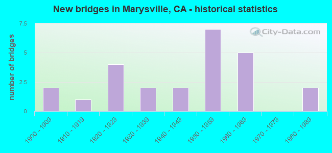
- New bridges - historical statistics
- 21900-1909
- 11910-1919
- 41920-1929
- 21930-1939
- 21940-1949
- 71950-1959
- 51960-1969
- 21980-1989

- Reconstructed bridges - Historical Statistics
- 11960-1969
- 01970-1979
- 21980-1989


- Bridge Condition - Deck
- 64.7%Good
- 35.3%Fair

- Bridge Condition - Superstructure
- 58.8%Good
- 41.2%Fair

- Bridge Condition - Substructure
- 70.6%Good
- 23.5%Fair
- 5.9%Poor

- Bridge Condition - Channel
- 18.8%Very good
- 18.8%Good
- 18.8%Satisfactory
- 18.8%Fair
- 18.8%Poor
- 6.3%Serious
Find on map >> Show street view
Structure Number: 16 001, Location: 03-YUB-020-13.90 (Lat: 39.230228, Lng: -121.400642), Route carried "on" structure: State highway 20, Year Built: 1938, Status: Open, Structure Length: 9.61m (31.53ft), Average Daily Traffic: 7,800 (year 2009), Truck Traffic: 6%, Average Future Daily Traffic: 13,568 (year 2039), Design Load: HS 15, Features Intersected: DRY CREEK
Minimum Vertical Clearance: 30+ m (98+ ft), Kilometerpoint: 13.900, Lanes on structure: 2, Base Highway Network: Yes (, Subroute: 1), Owner: State Highway Agency, Approaching Roadway Width: 7.3m (24.0ft), Skew: 4 degrees, Material/Design: Concrete continuous, Design/Construction: Tee Beam, Number Of Spans In Main Unit: 5, Length of Maximum Span: 21.0m (68.9ft), Curb or Sidewalk Widths: Left: 0.4m (1.3ft), Right: 0.4m (1.3ft), Curb-To-Curb Width: 7.9m (25.9ft), Out-to-Out Width: 9.2m (30.2ft)
Condition: Deck: Good, Superstructure: Good, Substructure: Good, Channel: Good, Operating Rating: 38.6 metric tons, Method Used To Determine Operating Rating: Load Factor (LF), Inventory Rating: 23.3 metric tons, Method Used To Determine Inventory Rating: Load Factor (LF), Structural Evaluation: Somewhat better than minimum adequacy, Deck Geometry: High priority of corrective action, Waterway Adequacy: Better than present minimum criteria, Approach Roadway Alignment: Equal to present desirable criteria, Designated Inspection Frequency: Every 24 months, Inspection Date: September 2021, Deck Structure Type: Concrete Cast-file-Place, Wearing Surface/Protective System: Wearing Surface: Bituminous
Find on map >> Show street view
Structure Number: 16 0019, Location: 03-YUB-070-16.01 (Lat: 39.167111, Lng: -121.590319), Route carried "on" structure: State highway 70, Year Built: 1957, Status: Open, Structure Length: 16.18m (53.08ft), Average Daily Traffic: 9,700 (year 2009), Truck Traffic: 13%, Average Future Daily Traffic: 20,049 (year 2040), Design Load: HS 20, Features Intersected: SIMMERLY SLOUGH
Minimum Vertical Clearance: 30+ m (98+ ft), Kilometerpoint: 16.010, Lanes on structure: 2, Base Highway Network: Yes (, Subroute: 1), Owner: State Highway Agency, Approaching Roadway Width: 8.5m (27.9ft), Material/Design: Concrete continuous, Design/Construction: Slab, Number Of Spans In Main Unit: 17, Length of Maximum Span: 9.8m (32.2ft), Curb or Sidewalk Widths: Left: 0.6m (2.0ft), Right: 1.6m (5.2ft), Curb-To-Curb Width: 8.5m (27.9ft), Out-to-Out Width: 10.7m (35.1ft)
Condition: Deck: Good, Superstructure: Good, Substructure: Fair, Channel: Good, Operating Rating: 56.4 metric tons, Method Used To Determine Operating Rating: Load Factor (LF), Inventory Rating: 34.0 metric tons, Method Used To Determine Inventory Rating: Load Factor (LF), Structural Evaluation: Somewhat better than minimum adequacy, Deck Geometry: Meets minimum limits, Waterway Adequacy: Equal to present desirable criteria, Approach Roadway Alignment: Equal to present desirable criteria, Designated Inspection Frequency: Every 24 months, Inspection Date: Febuary 2022, Deck Structure Type: Concrete Cast-file-Place, Wearing Surface/Protective System: Wearing Surface: Bituminous
Find on map >> Show street view
Structure Number: 16 002, Location: 03-YUB-070-25.81 (Lat: 39.306675, Lng: -121.595286), Route carried "on" structure: State highway 70, Year Built: 1941, Year Reconstructed: 1987, Status: Open, Structure Length: 3.26m (10.70ft), Average Daily Traffic: 9,700 (year 2009), Truck Traffic: 13%, Average Future Daily Traffic: 20,049 (year 2040), Design Load: HS 15, Features Intersected: SOUTH HONCUT CREEK
Minimum Vertical Clearance: 30+ m (98+ ft), Kilometerpoint: 25.810, Lanes on structure: 2, Base Highway Network: Yes (, Subroute: 1), Owner: State Highway Agency, Approaching Roadway Width: 12.2m (40.0ft), Material/Design: Concrete continuous, Design/Construction: Slab, Number Of Spans In Main Unit: 4, Length of Maximum Span: 9.1m (29.9ft), Curb-To-Curb Width: 12.2m (40.0ft), Out-to-Out Width: 13.3m (43.6ft)
Condition: Deck: Good, Superstructure: Good, Substructure: Good, Channel: Very good, Operating Rating: 40.2 metric tons, Method Used To Determine Operating Rating: Load and Resistance Factor Rating (LRFR) rating reported by rating factor(RF) method using HL-93 loadings, Inventory Rating: 28.2 metric tons, Method Used To Determine Inventory Rating: Load and Resistance Factor Rating (LRFR) rating reported by rating factor(RF) method using HL-93 loadings, Structural Evaluation: Better than present minimum criteria, Deck Geometry: Somewhat better than minimum adequacy, Waterway Adequacy: Equal to present desirable criteria, Approach Roadway Alignment: Equal to present desirable criteria, Designated Inspection Frequency: Every 24 months, Inspection Date: Febuary 2022, Deck Structure Type: Concrete Cast-file-Place, Wearing Surface/Protective System: Wearing Surface: Integral Concrete
Find on map >> Show street view
Structure Number: 16 0033, Location: 03-YUB-070-13.01 (Lat: 39.124561, Lng: -121.576886), Route carried "on" structure: State highway 70, Year Built: 1956, Status: Open, Structure Length: 2.01m (6.59ft), Average Daily Traffic: 37,500 (year 2009), Truck Traffic: 12%, Average Future Daily Traffic: 63,175 (year 2040), Design Load: HS 20, Features Intersected: FEATHER RIVER BLVD
Minimum Vertical Clearance: 30+ m (98+ ft), Kilometerpoint: 13.010, Lanes on structure: 4, Lanes under structure: 4, Base Highway Network: Yes (, Subroute: 1), Owner: State Highway Agency, Approaching Roadway Width: 32.0m (105.0ft), Skew: 10 degrees, Material/Design: Concrete, Design/Construction: Box Beam or Girders - Multiple, Number Of Spans In Main Unit: 1, Length of Maximum Span: 18.9m (62.0ft), Curb or Sidewalk Widths: Left: 0.6m (2.0ft), Right: 0.6m (2.0ft), Curb-To-Curb Width: 23.9m (78.4ft), Out-to-Out Width: 25.7m (84.3ft)
Condition: Deck: Good, Superstructure: Good, Substructure: Good, Operating Rating: 31.4 metric tons, Method Used To Determine Operating Rating: Load and Resistance Factor Rating (LRFR) rating reported by rating factor(RF) method using HL-93 loadings, Inventory Rating: 24.3 metric tons, Method Used To Determine Inventory Rating: Load and Resistance Factor Rating (LRFR) rating reported by rating factor(RF) method using HL-93 loadings, Structural Evaluation: Equal to present minimum criteria, Deck Geometry: Superior to present desirable criteria, Underclear: High priority of corrective action, Approach Roadway Alignment: Equal to present desirable criteria, Designated Inspection Frequency: Every 24 months, Inspection Date: Febuary 2022, Deck Structure Type: Concrete Cast-file-Place, Wearing Surface/Protective System: Wearing Surface: Bituminous
Find on map >> Show street view
Structure Number: 16 0034, Location: 03-YUB-070-13.60 (Lat: 39.133889, Lng: -121.589167), Route carried "on" structure: State highway 70, Year Built: 1960, Status: Open, Structure Length: 73.52m (241.21ft), Average Daily Traffic: 37,500 (year 2009), Truck Traffic: 12%, Average Future Daily Traffic: 63,175 (year 2040), Design Load: HS 20, Features Intersected: YUBA RIVER, UP RR SPUR
Minimum Vertical Clearance: 30+ m (98+ ft), Kilometerpoint: 13.600, Lanes on structure: 4, Base Highway Network: Yes (, Subroute: 1), Owner: State Highway Agency, Approaching Roadway Width: 18.2m (59.7ft), Skew: 39 degrees, Material/Design: Concrete continuous, Design/Construction: Box Beam or Girders - Multiple, Number Of Spans In Main Unit: 27, Number Of Approach Spans: 2, Length of Maximum Span: 26.8m (87.9ft), Curb or Sidewalk Widths: Left: 1.5m (4.9ft), Right: 1.5m (4.9ft), Curb-To-Curb Width: 18.2m (59.7ft), Out-to-Out Width: 22.5m (73.8ft)
Condition: Deck: Good, Superstructure: Good, Substructure: Good, Channel: Good, Operating Rating: 73.2 metric tons, Method Used To Determine Operating Rating: Load Factor (LF), Inventory Rating: 44.1 metric tons, Method Used To Determine Inventory Rating: Load Factor (LF), Structural Evaluation: Better than present minimum criteria, Deck Geometry: Meets minimum limits, Underclear: High priority of corrective action, Waterway Adequacy: Equal to present desirable criteria, Approach Roadway Alignment: Equal to present minimum criteria, Designated Inspection Frequency: Every 24 months, Underwater Inspection Frequency: Every 60 months, Inspection Date: Febuary 2022, Underwater Inspection Date: October 2020, Deck Structure Type: Concrete Cast-file-Place, Wearing Surface/Protective System: Wearing Surface: Integral Concrete
Find on map >> Show street view
Structure Number: 16 0038, Location: 03-YUB-070-14.08-MVL (Lat: 39.135792, Lng: -121.589747), Route carried "on" structure: State highway 70, Year Built: 1960, Status: Open, Structure Length: 1.65m (5.41ft), Average Daily Traffic: 37,500 (year 2009), Truck Traffic: 12%, Average Future Daily Traffic: 63,175 (year 2040), Design Load: HS 20, Features Intersected: FIRST STREET
Minimum Vertical Clearance: 30+ m (98+ ft), Kilometerpoint: 14.080, Lanes on structure: 5, Lanes under structure: 2, Base Highway Network: Yes (, Subroute: 1), Owner: State Highway Agency, Approaching Roadway Width: 25.4m (83.3ft), Skew: 30 degrees, Material/Design: Concrete, Design/Construction: Slab, Number Of Spans In Main Unit: 1, Length of Maximum Span: 15.2m (49.9ft), Curb or Sidewalk Widths: Left: 1.5m (4.9ft), Right: 1.5m (4.9ft), Curb-To-Curb Width: 25.4m (83.3ft), Out-to-Out Width: 28.7m (94.2ft)
Condition: Deck: Good, Superstructure: Good, Substructure: Good, Operating Rating: 55.1 metric tons, Method Used To Determine Operating Rating: Load Factor (LF), Inventory Rating: 33.0 metric tons, Method Used To Determine Inventory Rating: Load Factor (LF), Structural Evaluation: Better than present minimum criteria, Deck Geometry: Better than present minimum criteria, Underclear: Meets minimum limits, Approach Roadway Alignment: Equal to present desirable criteria, Designated Inspection Frequency: Every 48 months, Inspection Date: Febuary 2022, Deck Structure Type: Concrete Cast-file-Place, Wearing Surface/Protective System: Wearing Surface: Bituminous
Find on map >> Show street view
Structure Number: 16C0001, Location: 0.5 MI SE/O E 10TH ST (Lat: 39.142031, Lng: -121.577056), Route carried "on" structure: County highway , Year Built: 1957, Year Reconstructed: 1987, Status: Open, Structure Length: 12.71m (41.70ft), Average Daily Traffic: 11,630 (year 2007), Truck Traffic: 7%, Average Future Daily Traffic: 38,163 (year 2041), Design Load: HS 20, Features Intersected: YUBA RIVER, Facility Carried by Structure: SIMPSON LN
Minimum Vertical Clearance: 30+ m (98+ ft), Kilometerpoint: 0.000, Lanes on structure: 2, Owner: County Highway Agency, Approaching Roadway Width: 12.2m (40.0ft), Skew: 3 degrees, Material/Design: Prestressed concrete, Design/Construction: Tee Beam, Number Of Spans In Main Unit: 5, Length of Maximum Span: 25.3m (83.0ft), Curb-To-Curb Width: 12.2m (40.0ft), Out-to-Out Width: 13.3m (43.6ft)
Condition: Deck: Fair, Superstructure: Good, Substructure: Poor, Channel: Serious, Operating Rating: 45.7 metric tons, Method Used To Determine Operating Rating: Load and Resistance Factor Rating (LRFR) rating reported by rating factor(RF) method using HL-93 loadings, Inventory Rating: 26.9 metric tons, Method Used To Determine Inventory Rating: Load and Resistance Factor Rating (LRFR) rating reported by rating factor(RF) method using HL-93 loadings, Structural Evaluation: Meets minimum limits, Deck Geometry: Somewhat better than minimum adequacy, Waterway Adequacy: Equal to present desirable criteria, Approach Roadway Alignment: Equal to present desirable criteria, Length Of Structure Improvement: 12.71m (41.70ft), Designated Inspection Frequency: Every 24 months, Underwater Inspection Frequency: Every 60 months, Inspection Date: August 2020, Underwater Inspection Date: May 2020, Bridge Improvement Cost: $1,690,000, Roadway Improvement Cost: $338,000, Total Project Cost: $2,839,000 ( Estimate for 2021), Deck Structure Type: Concrete Cast-file-Place, Wearing Surface/Protective System: Wearing Surface: Bituminous
Find on map >> Show street view
Structure Number: 16C0003, Location: 0.8 MI N OF SR 20 (Lat: 39.225050, Lng: -121.510792), Route carried "on" structure: County highway , Year Built: 1957, Status: Open, Structure Length: 1.55m (5.09ft), Average Daily Traffic: 2,670 (year 2013), Truck Traffic: 10%, Average Future Daily Traffic: 6,520 (year 2040), Features Intersected: JACK SLOUGH, Facility Carried by Structure: LOMA RICA RD
Minimum Vertical Clearance: 30+ m (98+ ft), Kilometerpoint: 0.000, Lanes on structure: 2, Owner: County Highway Agency, Approaching Roadway Width: 8.8m (28.9ft), Material/Design: Steel, Design/Construction: Culvert, Number Of Spans In Main Unit: 3, Length of Maximum Span: 4.3m (14.1ft), Curb or Sidewalk Widths: Left: 0.1m (0.3ft), Right: 0.1m (0.3ft), Curb-To-Curb Width: 9.5m (31.2ft), Out-to-Out Width: 10.1m (33.1ft)
Condition: Channel: Poor, Culverts: Poor, Operating Rating: 54.1 metric tons, Method Used To Determine Operating Rating: Load Factor (LF), Inventory Rating: 32.4 metric tons, Method Used To Determine Inventory Rating: Load Factor (LF), Structural Evaluation: Meets minimum limits, Deck Geometry: Meets minimum limits, Waterway Adequacy: Better than present minimum criteria, Approach Roadway Alignment: Equal to present desirable criteria, Length Of Structure Improvement: 1.55m (5.09ft), Designated Inspection Frequency: Every 24 months, Inspection Date: August 2020, Bridge Improvement Cost: $153,000, Roadway Improvement Cost: $30,000, Total Project Cost: $257,000 ( Estimate for 2017)
Find on map >> Show street view
Structure Number: 16C0011, Location: 0.1 MI N/W OF SR 20 (Lat: 39.210914, Lng: -121.311056), Route carried "on" structure: County highway , Year Built: 1903, Status: Posted for load, Structure Length: 2.93m (9.61ft), Average Daily Traffic: 50 (year 2011), Truck Traffic: 2%, Average Future Daily Traffic: 153 (year 2040), Features Intersected: DEEP RAVINE NO 2, Facility Carried by Structure: TIMBUCTOO ROAD
Minimum Vertical Clearance: 30+ m (98+ ft), Kilometerpoint: 0.000, Lanes on structure: 1, Owner: County Highway Agency, Approaching Roadway Width: 4.9m (16.1ft), Material/Design: Steel, Design/Construction: Truss - Thru, Number Of Spans In Main Unit: 1, Number Of Approach Spans: 1, Length of Maximum Span: 21.3m (69.9ft), Curb or Sidewalk Widths: Left: 0.2m (0.7ft), Right: 0.2m (0.7ft), Curb-To-Curb Width: 4.2m (13.8ft), Out-to-Out Width: 4.9m (16.1ft)
Condition: Deck: Good, Superstructure: Fair, Substructure: Fair, Channel: Poor, Operating Rating: 8.4 metric tons, Method Used To Determine Operating Rating: Allowable Stress (AS), Inventory Rating: 3.9 metric tons, Method Used To Determine Inventory Rating: Allowable Stress (AS), Structural Evaluation: High priority of corrective action, Deck Geometry: Somewhat better than minimum adequacy, Waterway Adequacy: Equal to present minimum criteria, Approach Roadway Alignment: Meets minimum limits, Bridge Posting: Required (Relationship of Operating Rating to Maximum Legal Load: > 39.9% below), Designated Inspection Frequency: Every 24 months, Critical Feature Inspection Frequency: Every 24 months, Inspection Date: August 2020, Critical Feature Inspection Date: May 2020, Deck Structure Type: Wood or Timber, Wearing Surface/Protective System: Wearing Surface: Wood or Timber
Find on map >> Show street view
Structure Number: 16C002, Location: 0.3 MI S PLUMAS ARBOGA RD (Lat: 39.023297, Lng: -121.509103), Route carried "on" structure: County highway , Year Built: 1948, Status: Open, Structure Length: 1.89m (6.20ft), Average Daily Traffic: 1,630 (year 2013), Truck Traffic: 10%, Average Future Daily Traffic: 3,282 (year 2040), Design Load: HS 20, Features Intersected: BEST SLOUGH, Facility Carried by Structure: FORTY MILE RD
Minimum Vertical Clearance: 30+ m (98+ ft), Kilometerpoint: 0.000, Lanes on structure: 2, Owner: County Highway Agency, Approaching Roadway Width: 7.3m (24.0ft), Material/Design: Concrete continuous, Design/Construction: Slab, Number Of Spans In Main Unit: 3, Length of Maximum Span: 6.1m (20.0ft), Curb or Sidewalk Widths: Left: 0.6m (2.0ft), Right: 0.6m (2.0ft), Curb-To-Curb Width: 7.4m (24.3ft), Out-to-Out Width: 9.2m (30.2ft)
Condition: Deck: Fair, Superstructure: Fair, Substructure: Good, Channel: Poor, Operating Rating: 41.5 metric tons, Method Used To Determine Operating Rating: Load Factor (LF), Inventory Rating: 28.8 metric tons, Method Used To Determine Inventory Rating: Load Factor (LF), Structural Evaluation: Somewhat better than minimum adequacy, Deck Geometry: Meets minimum limits, Waterway Adequacy: Equal to present minimum criteria, Approach Roadway Alignment: Equal to present minimum criteria, Designated Inspection Frequency: Every 24 months, Inspection Date: August 2020, Deck Structure Type: Concrete Cast-file-Place
Find on map >> Show street view
Structure Number: 16C003, Location: 0.2 MI W OREGON HOUSE JCT (Lat: 39.357719, Lng: -121.285369), Route carried "on" structure: County highway , Year Built: 1964, Status: Open, Structure Length: 4.72m (15.49ft), Average Daily Traffic: 2,400 (year 2013), Truck Traffic: 10%, Average Future Daily Traffic: 3,741 (year 2039), Design Load: HS 20, Features Intersected: OREGON HOUSE CREEK, Facility Carried by Structure: MARYSVILLE RD
Minimum Vertical Clearance: 30+ m (98+ ft), Kilometerpoint: 0.000, Lanes on structure: 2, Owner: County Highway Agency, Approaching Roadway Width: 8.5m (27.9ft), Skew: 3 degrees, Material/Design: Concrete continuous, Design/Construction: Tee Beam, Number Of Spans In Main Unit: 3, Length of Maximum Span: 18.9m (62.0ft), Curb-To-Curb Width: 9.8m (32.2ft), Out-to-Out Width: 10.0m (32.8ft)
Condition: Deck: Good, Superstructure: Good, Substructure: Good, Channel: Very good, Operating Rating: 29.8 metric tons, Method Used To Determine Operating Rating: Load and Resistance Factor Rating (LRFR) rating reported by rating factor(RF) method using HL-93 loadings, Inventory Rating: 23.0 metric tons, Method Used To Determine Inventory Rating: Load and Resistance Factor Rating (LRFR) rating reported by rating factor(RF) method using HL-93 loadings, Structural Evaluation: Equal to present minimum criteria, Deck Geometry: Meets minimum limits, Waterway Adequacy: Equal to present desirable criteria, Approach Roadway Alignment: Equal to present desirable criteria, Designated Inspection Frequency: Every 24 months, Inspection Date: July 2021, Deck Structure Type: Concrete Cast-file-Place, Wearing Surface/Protective System: Wearing Surface: Bituminous
Find on map >> Show street view
Structure Number: 16C0031, Location: 0.5 MI E JACK SLOUGH RD (Lat: 39.214403, Lng: -121.551678), Route carried "on" structure: County highway , Year Built: 1966, Status: Open, Structure Length: 3.05m (10.01ft), Average Daily Traffic: 1,030 (year 2013), Truck Traffic: 10%, Average Future Daily Traffic: 4,081 (year 2040), Design Load: HS 20, Features Intersected: JACK SLOUGH, Facility Carried by Structure: WOODRUFF LANE
Minimum Vertical Clearance: 30+ m (98+ ft), Kilometerpoint: 0.000, Lanes on structure: 2, Owner: County Highway Agency, Approaching Roadway Width: 7.3m (24.0ft), Material/Design: Steel continuous, Design/Construction: Stringer/Multi-beam, Number Of Spans In Main Unit: 2, Length of Maximum Span: 15.1m (49.5ft), Curb-To-Curb Width: 8.5m (27.9ft), Out-to-Out Width: 8.7m (28.5ft)
Condition: Deck: Fair, Superstructure: Fair, Substructure: Good, Channel: Satisfactory, Operating Rating: 74.5 metric tons, Method Used To Determine Operating Rating: Load Factor (LF), Inventory Rating: 44.7 metric tons, Method Used To Determine Inventory Rating: Load Factor (LF), Structural Evaluation: Somewhat better than minimum adequacy, Deck Geometry: Somewhat better than minimum adequacy, Waterway Adequacy: Equal to present minimum criteria, Approach Roadway Alignment: Equal to present desirable criteria, Designated Inspection Frequency: Every 24 months, Inspection Date: August 2020, Deck Structure Type: Concrete Cast-file-Place
Find on map >> Show street view
Structure Number: 16C0034, Location: BETWEEN C & D STREETS (Lat: 39.150383, Lng: -121.589633), Route carried "on" structure: City street , Year Built: 1958, Year Reconstructed: 1974, Status: Open, Structure Length: 0.70m (2.30ft), Average Daily Traffic: 16,500 (year 2017), Truck Traffic: 10%, Average Future Daily Traffic: 26,168 (year 2041), Features Intersected: ELLIS LAKE, Facility Carried by Structure: FOURTEENTH ST
Minimum Vertical Clearance: 30+ m (98+ ft), Kilometerpoint: 0.000, Lanes on structure: 2, Owner: City or Municipal Highway Agency, Approaching Roadway Width: 14.9m (48.9ft), Material/Design: Concrete, Design/Construction: Tee Beam, Number Of Spans In Main Unit: 1, Length of Maximum Span: 7.0m (23.0ft), Curb or Sidewalk Widths: Left: 1.8m (5.9ft), Right: 1.8m (5.9ft), Curb-To-Curb Width: 14.9m (48.9ft), Out-to-Out Width: 19.5m (64.0ft)
Condition: Deck: Good, Superstructure: Good, Substructure: Good, Channel: Very good, Operating Rating: 40.5 metric tons, Method Used To Determine Operating Rating: Field evaluation and documented engineering judgment, Inventory Rating: 24.3 metric tons, Method Used To Determine Inventory Rating: Field evaluation and documented engineering judgment, Structural Evaluation: Equal to present minimum criteria, Deck Geometry: Superior to present desirable criteria, Waterway Adequacy: Superior to present desirable criteria, Approach Roadway Alignment: Equal to present desirable criteria, Designated Inspection Frequency: Every 24 months, Underwater Inspection Frequency: Every 60 months, Inspection Date: March 2021, Underwater Inspection Date: June 2020, Deck Structure Type: Concrete Cast-file-Place, Wearing Surface/Protective System: Wearing Surface: Bituminous
Find on map >> Show street view
Structure Number: 16C0044, Location: 0.9 MI EAST OF S.R. 70 (Lat: 39.219575, Lng: -121.583947), Route carried "on" structure: County highway , Year Built: 1929, Status: Open, Structure Length: 1.01m (3.31ft), Average Daily Traffic: 900 (year 2008), Truck Traffic: 10%, Average Future Daily Traffic: 3,261 (year 2040), Features Intersected: SIMMERLY SLOUGH, Facility Carried by Structure: WOODRUFF LN
Minimum Vertical Clearance: 30+ m (98+ ft), Kilometerpoint: 0.000, Lanes on structure: 2, Owner: County Highway Agency, Approaching Roadway Width: 6.1m (20.0ft), Material/Design: Concrete continuous, Design/Construction: Slab, Number Of Spans In Main Unit: 2, Length of Maximum Span: 4.7m (15.4ft), Curb or Sidewalk Widths: Left: 0.1m (0.3ft), Right: 0.1m (0.3ft), Curb-To-Curb Width: 5.9m (19.4ft), Out-to-Out Width: 6.7m (22.0ft)
Condition: Deck: Good, Superstructure: Good, Substructure: Good, Channel: Fair, Operating Rating: 28.2 metric tons, Method Used To Determine Operating Rating: Load Factor (LF), Inventory Rating: 16.8 metric tons, Method Used To Determine Inventory Rating: Load Factor (LF), Structural Evaluation: Meets minimum limits, Deck Geometry: High priority of replacement, Waterway Adequacy: Somewhat better than minimum adequacy, Approach Roadway Alignment: Equal to present desirable criteria, Designated Inspection Frequency: Every 24 months, Inspection Date: August 2020, Deck Structure Type: Concrete Cast-file-Place, Wearing Surface/Protective System: Wearing Surface: Bituminous
Find on map >> Show street view
Structure Number: 16C0064, Location: 0.2 MI NORTH KIMBALL RD (Lat: 39.180128, Lng: -121.571122), Route carried "on" structure: County highway , Year Built: 1982, Status: Open, Structure Length: 4.63m (15.19ft), Average Daily Traffic: 590 (year 2011), Truck Traffic: 4%, Average Future Daily Traffic: 849 (year 2038), Design Load: HS 20, Features Intersected: JACK SLOUGH, Facility Carried by Structure: JACK SLOUGH RD
Minimum Vertical Clearance: 30+ m (98+ ft), Kilometerpoint: 0.000, Lanes on structure: 2, Owner: County Highway Agency, Approaching Roadway Width: 7.3m (24.0ft), Material/Design: Concrete continuous, Design/Construction: Slab, Number Of Spans In Main Unit: 5, Length of Maximum Span: 9.1m (29.9ft), Curb-To-Curb Width: 9.8m (32.2ft), Out-to-Out Width: 10.0m (32.8ft)
Condition: Deck: Fair, Superstructure: Fair, Substructure: Good, Channel: Satisfactory, Operating Rating: 78.1 metric tons, Method Used To Determine Operating Rating: Load Factor (LF), Inventory Rating: 47.0 metric tons, Method Used To Determine Inventory Rating: Load Factor (LF), Structural Evaluation: Somewhat better than minimum adequacy, Deck Geometry: Equal to present minimum criteria, Waterway Adequacy: Equal to present desirable criteria, Approach Roadway Alignment: Equal to present minimum criteria, Designated Inspection Frequency: Every 24 months, Inspection Date: March 2021, Deck Structure Type: Concrete Cast-file-Place
Find on map >> Show street view
Structure Number: 16C0074, Location: 0.7 MI N WOODRUFF LANE (Lat: 39.223683, Lng: -121.540439), Route carried "on" structure: County highway , Year Built: 1988, Status: Open, Structure Length: 4.36m (14.30ft), Average Daily Traffic: 1,470 (year 2007), Truck Traffic: 13%, Average Future Daily Traffic: 2,444 (year 2040), Design Load: HS 20+Mod, Features Intersected: JACK SLOUGH, Facility Carried by Structure: MATHEWS LANE
Minimum Vertical Clearance: 30+ m (98+ ft), Kilometerpoint: 0.000, Lanes on structure: 2, Owner: County Highway Agency, Approaching Roadway Width: 9.4m (30.8ft), Material/Design: Concrete continuous, Design/Construction: Slab, Number Of Spans In Main Unit: 5, Length of Maximum Span: 8.5m (27.9ft), Curb-To-Curb Width: 9.9m (32.5ft), Out-to-Out Width: 10.5m (34.4ft)
Condition: Deck: Fair, Superstructure: Fair, Substructure: Good, Channel: Fair, Operating Rating: 54.1 metric tons, Method Used To Determine Operating Rating: Assigned rating based on Load Factor Design (LFD) reported in metric tons, Inventory Rating: 32.4 metric tons, Method Used To Determine Inventory Rating: Assigned rating based on Load Factor Design (LFD) reported in metric tons, Structural Evaluation: Somewhat better than minimum adequacy, Deck Geometry: Somewhat better than minimum adequacy, Waterway Adequacy: Better than present minimum criteria, Approach Roadway Alignment: Better than present minimum criteria, Designated Inspection Frequency: Every 24 months, Inspection Date: August 2020, Deck Structure Type: Concrete Cast-file-Place
Find on map >> Show street view
Structure Number: 16C0075, Location: 1.0 MI E OF SR 70 (Lat: 39.198019, Lng: -121.578247), Route carried "on" structure: County highway , Year Built: 1928, Status: Posted for load, Structure Length: 1.40m (4.59ft), Average Daily Traffic: 40 (year 2013), Truck Traffic: 1%, Average Future Daily Traffic: 82 (year 2040), Features Intersected: SIMMERLY SLOUGH, Facility Carried by Structure: ELLIS RD
Minimum Vertical Clearance: 30+ m (98+ ft), Kilometerpoint: 0.000, Lanes on structure: 2, Owner: County Highway Agency, Approaching Roadway Width: 6.1m (20.0ft), Material/Design: Concrete continuous, Design/Construction: Slab, Number Of Spans In Main Unit: 3, Length of Maximum Span: 4.6m (15.1ft), Curb or Sidewalk Widths: Left: 0.1m (0.3ft), Right: 0.1m (0.3ft), Curb-To-Curb Width: 6.1m (20.0ft), Out-to-Out Width: 6.9m (22.6ft)
Condition: Deck: Fair, Superstructure: Fair, Substructure: Fair, Channel: Fair, Operating Rating: 9.1 metric tons, Method Used To Determine Operating Rating: Field evaluation and documented engineering judgment, Inventory Rating: 5.5 metric tons, Method Used To Determine Inventory Rating: Field evaluation and documented engineering judgment, Structural Evaluation: High priority of replacement, Deck Geometry: Somewhat better than minimum adequacy, Waterway Adequacy: Better than present minimum criteria, Approach Roadway Alignment: Equal to present desirable criteria, Bridge Posting: Required (Relationship of Operating Rating to Maximum Legal Load: > 39.9% below), Length Of Structure Improvement: 1.40m (4.59ft), Designated Inspection Frequency: Every 12 months, Inspection Date: August 2021, Bridge Improvement Cost: $218,000, Roadway Improvement Cost: $43,000, Total Project Cost: $367,000 ( Estimate for 2017), Deck Structure Type: Concrete Cast-file-Place
Find on map >> Show street view
Structure Number: 16C009, Location: 0.3 MI S OF LA PORTE RD (Lat: 39.439656, Lng: -121.315564), Route carried "on" structure: County highway , Year Built: 1950, Status: Open, Structure Length: 0.70m (2.30ft), Average Daily Traffic: 150 (year 2007), Truck Traffic: 20%, Average Future Daily Traffic: 213 (year 2039), Features Intersected: SOUTH HONCUT CREEK, Facility Carried by Structure: VIERRA RD
Minimum Vertical Clearance: 30+ m (98+ ft), Kilometerpoint: 0.000, Lanes on structure: 1, Owner: County Highway Agency, Approaching Roadway Width: 3.7m (12.1ft), Skew: 2 degrees, Material/Design: Steel, Design/Construction: Stringer/Multi-beam, Number Of Spans In Main Unit: 1, Length of Maximum Span: 6.2m (20.3ft), Curb-To-Curb Width: 4.7m (15.4ft), Out-to-Out Width: 4.9m (16.1ft)
Condition: Deck: Good, Superstructure: Fair, Substructure: Fair, Channel: Satisfactory, Operating Rating: 40.5 metric tons, Method Used To Determine Operating Rating: Load Factor (LF), Inventory Rating: 24.3 metric tons, Method Used To Determine Inventory Rating: Load Factor (LF), Structural Evaluation: Somewhat better than minimum adequacy, Deck Geometry: High priority of replacement, Waterway Adequacy: Equal to present minimum criteria, Approach Roadway Alignment: Meets minimum limits, Designated Inspection Frequency: Every 24 months, Other Special Inspection Frequency: Every 48 months, Inspection Date: July 2021, Other Special Inspection Date: July 2021, Deck Structure Type: Corrugated Steel, Wearing Surface/Protective System: Wearing Surface: Bituminous
Find on map >> Show street view
Structure Number: 16 0016, Location: 03-YUB-020-1.55-MVL (Lat: 39.148622, Lng: -121.585669), Route carried "under" structure: State highway 20, Year Built: 1964, Structure Length: 0. m, Average Daily Traffic: 24,100 (year 2009), Truck Traffic: 9%, Features Intersected: SR 20 (12TH ST), Facility Carried by Structure: UP RR & AMTRAK
Minimum Vertical Clearance: 4.57m (14.99ft), Kilometerpoint: 1.550, Lanes under structure: 4, Material/Design: Steel, Design/Construction: Girder and Floorbeam System, Length of Maximum Span: 20.1m (65.9ft)
Find on map >> Show street view
Structure Number: 16 0018, Location: 03-YUB-070-15.11-MVL (Lat: 39.154303, Lng: -121.587989), Route carried "under" structure: State highway 70, Year Built: 1911, Structure Length: 0. m, Average Daily Traffic: 14,800 (year 2009), Truck Traffic: 13%, Features Intersected: STATE ROUTE 70 (B ST), Facility Carried by Structure: UP RR & AMTRAK
Minimum Vertical Clearance: 4.29m (14.07ft), Kilometerpoint: 15.110, Lanes under structure: 2, Material/Design: Steel, Design/Construction: Stringer/Multi-beam, Length of Maximum Span: 7.0m (23.0ft)
Find on map >> Show street view
Structure Number: 16 0026, Location: 03-YUB-070-15.41-MVL (Lat: 39.158514, Lng: -121.589411), Route carried "under" structure: State highway 70, Year Built: 1957, Structure Length: 0. m, Average Daily Traffic: 19,500 (year 2009), Truck Traffic: 12%, Features Intersected: STATE ROUTE 70 (B ST), Facility Carried by Structure: UP RR & BNSF RY
Minimum Vertical Clearance: 4.47m (14.67ft), Kilometerpoint: 15.410, Lanes under structure: 2, Material/Design: Steel, Design/Construction: Girder and Floorbeam System, Length of Maximum Span: 15.2m (49.9ft)
Find on map >> Show street view
Structure Number: 16C0014, Location: 0.1 MI W/O H ST (Lat: 39.149750, Lng: -121.597792), Route carried "under" structure: City street , Year Built: 1925, Structure Length: 0. m, Average Daily Traffic: 800 (year 1985), Truck Traffic: 2%, Features Intersected: 14TH STREET, Facility Carried by Structure: UP RR & BNSF RY
Minimum Vertical Clearance: 4.09m (13.42ft), Kilometerpoint: 0.000, Lanes under structure: 2, Material/Design: Concrete, Design/Construction: Slab, Length of Maximum Span: 9.3m (30.5ft)
Find on map >> Show street view
Structure Number: 16C0024, Location: 0.5 MI WEST OF S.R. 70 (Lat: 39.139367, Lng: -121.599450), Route carried "under" structure: City street , Year Built: 1907, Structure Length: 0. m, Average Daily Traffic: 8,000 (year 1980), Truck Traffic: 2%, Features Intersected: 5TH STREET, Facility Carried by Structure: UP RR & BNSF RY
Minimum Vertical Clearance: 4.52m (14.83ft), Kilometerpoint: 0.000, Lanes under structure: 2, Material/Design: Concrete continuous, Design/Construction: Slab, Length of Maximum Span: 11.5m (37.7ft)
Find on map >> Show street view
Structure Number: 16C0094, Location: RIVERFRONT PK IN MRSVL (Lat: 39.133247, Lng: -121.591536), Route carried "under" structure: City street , Year Built: 1927, Structure Length: 0. m, Average Daily Traffic: 300 (year 1991), Truck Traffic: 3%, Features Intersected: BIZ JOHNSON DR, Facility Carried by Structure: UP RR & BNSF RY
Minimum Vertical Clearance: 4.54m (14.90ft), Kilometerpoint: 0.000, Lanes under structure: 2, Material/Design: Steel, Design/Construction: Truss - Thru, Length of Maximum Span: 31.1m (102.0ft)
Find on map >> Show street view
Structure Number: 16C0095, Location: BIZ JOHNSON DR & FEA RIV (Lat: 39.138392, Lng: -121.607228), Route carried "under" structure: City street , Year Built: 1930, Structure Length: 0. m, Average Daily Traffic: 300 (year 1991), Truck Traffic: 3%, Features Intersected: BIZ JOHNSON DR, Facility Carried by Structure: UP RR & BNSF RY
Minimum Vertical Clearance: 8.23m (27.00ft), Kilometerpoint: 0.000, Lanes under structure: 2, Material/Design: Prestressed concrete, Design/Construction: Box Beam or Girders - Multiple, Length of Maximum Span: 12.8m (42.0ft)