Bridge Statistics for Maryland City, Maryland (MD)
Condition, Traffic, Stress, Structural Evaluation, Project Costs
- National Bridge Inventory (NBI) Statistics
- 14Number of bridges
- 305ft / 92.8mTotal length
- $8,595,000Total costs
- 389,399Total average daily traffic
- 10,968Total average daily truck traffic
- 535,186Total future (year 2026) average daily traffic
- National Bridge Inventory (NBI) Registered Bridges for Maryland City
- No street view available for this location
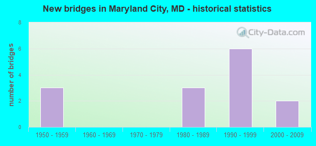
- New bridges - historical statistics
- 31950-1959
- 31980-1989
- 61990-1999
- 22000-2009


- Bridge Condition - Deck
- 72.7%Good
- 27.3%Satisfactory

- Bridge Condition - Superstructure
- 9.1%Very good
- 54.5%Good
- 36.4%Satisfactory

- Bridge Condition - Substructure
- 9.1%Very good
- 18.2%Good
- 72.7%Satisfactory

- Bridge Condition - Channel
- 12.5%Very good
- 50.0%Good
- 37.5%Satisfactory

- Bridge Condition - Culverts
- 66.7%Good
- 33.3%Satisfactory
Find on map >> Show street view
Structure Number: 51640-00742, Location: NORTH TRACT (Lat: 39.079167, Lng: -76.765333), Route carried "on" structure: Federal lands road , Year Built: 2004, Status: Open, Structure Length: 6.19m (20.31ft), Average Daily Traffic: 20 (year 2021), Average Future Daily Traffic: 40 (year 2041), Design Load: HL 93, Features Intersected: LITTLE PATUXENT RIVER, Facility Carried by Structure: WILDLIFE LOOP ROAD
Minimum Vertical Clearance: 30.48m (100.00ft), Kilometerpoint: 1.127, Lanes on structure: 2, Owner: Bureau of Fish and Wildlife, Approaching Roadway Width: 6.1m (20.0ft), Material/Design: Prestressed concrete, Design/Construction: Stringer/Multi-beam, Number Of Spans In Main Unit: 2, Length of Maximum Span: 30.2m (99.1ft), Curb-To-Curb Width: 7.6m (24.9ft), Out-to-Out Width: 8.2m (26.9ft)
Condition: Deck: Good, Superstructure: Very good, Substructure: Very good, Channel: Good, Operating Rating: 87.1 metric tons, Method Used To Determine Operating Rating: Load Factor (LF), Inventory Rating: 52.6 metric tons, Method Used To Determine Inventory Rating: Load Factor (LF), Structural Evaluation: Equal to present desirable criteria, Deck Geometry: Equal to present minimum criteria, Waterway Adequacy: Better than present minimum criteria, Approach Roadway Alignment: Better than present minimum criteria, Designated Inspection Frequency: Every 24 months, Inspection Date: August 2021, Deck Structure Type: Concrete Cast-file-Place, Wearing Surface/Protective System: Wearing Surface: Monolithic Concrete
Find on map >> Show street view
Structure Number: 10000002021103, Location: MD32 & CANINE RD (Lat: 39.109661, Lng: -76.775756), Route carried "on" structure: Ramp State highway 295, Year Built: 1991, Status: Open, Structure Length: 0.97m (3.18ft), Average Daily Traffic: 1,440 (year 2007), Average Future Daily Traffic: 1,660 (year 2027), Design Load: HS 20, Features Intersected: BR OF LITTLE PATUXENT RI
Minimum Vertical Clearance: 30+ m (98+ ft), Kilometerpoint: 0.840, Lanes on structure: 4, Base Highway Network: Yes, Owner: State Highway Agency, Approaching Roadway Width: 21.3m (69.9ft), Skew: 2 degrees, Material/Design: Concrete, Design/Construction: Culvert, Number Of Spans In Main Unit: 3, Length of Maximum Span: 2.7m (8.9ft)
Condition: Channel: Good, Culverts: Good, Operating Rating: 32.7 metric tons, Method Used To Determine Operating Rating: Field evaluation and documented engineering judgment, Inventory Rating: 32.7 metric tons, Method Used To Determine Inventory Rating: Field evaluation and documented engineering judgment, Structural Evaluation: Better than present minimum criteria, Waterway Adequacy: Better than present minimum criteria, Approach Roadway Alignment: Equal to present minimum criteria, Designated Inspection Frequency: Every 24 months, Inspection Date: April 2021, Wearing Surface/Protective System: Wearing Surface: Bituminous
Find on map >> Show street view
Structure Number: 100000130115013, Location: ON ANNE ARUNDEL CO LINE (Lat: 39.125681, Lng: -76.790775), Route carried "on" structure: State highway 32, Year Built: 1983, Status: Open, Structure Length: 9.21m (30.22ft), Average Daily Traffic: 65,902 (year 2009), Truck Traffic: 8%, Average Future Daily Traffic: 35,473 (year 2026), Design Load: HS 20, Features Intersected: CSX TRANSPORTATION
Minimum Vertical Clearance: 30+ m (98+ ft), Kilometerpoint: 0.011, Lanes on structure: 2, Base Highway Network: Yes, Owner: State Highway Agency, Approaching Roadway Width: 12.2m (40.0ft), Skew: 1 degrees, Material/Design: Steel, Design/Construction: Stringer/Multi-beam, Number Of Spans In Main Unit: 3, Length of Maximum Span: 48.2m (158.1ft), Curb-To-Curb Width: 12.2m (40.0ft), Out-to-Out Width: 13.2m (43.3ft)
Condition: Deck: Good, Superstructure: Satisfactory, Substructure: Satisfactory, Operating Rating: 74.8 metric tons, Method Used To Determine Operating Rating: Load Factor (LF), Inventory Rating: 44.9 metric tons, Method Used To Determine Inventory Rating: Load Factor (LF), Structural Evaluation: Equal to present minimum criteria, Deck Geometry: Better than present minimum criteria, Underclear: Equal to present desirable criteria, Approach Roadway Alignment: Equal to present desirable criteria, Designated Inspection Frequency: Every 24 months, Inspection Date: August 2020, Deck Structure Type: Concrete Cast-file-Place, Wearing Surface/Protective System: Wearing Surface: Monolithic Concrete, Deck Protection: Epoxy Coated Reinforcing
Find on map >> Show street view
Structure Number: 10000013012501, Location: ON ANNE ARUNDEL CO LINE (Lat: 39.122450, Lng: -76.796622), Route carried "on" structure: State highway 732R, Year Built: 1989, Status: Open, Structure Length: 6.19m (20.31ft), Average Daily Traffic: 15,761 (year 2009), Truck Traffic: 8%, Average Future Daily Traffic: 13,780 (year 2026), Design Load: HS 20, Features Intersected: CSX TRANS, BROCK BRIDGE
Minimum Vertical Clearance: 30+ m (98+ ft), Kilometerpoint: 0.000, Lanes on structure: 2, Lanes under structure: 2, Owner: State Highway Agency, Approaching Roadway Width: 9.8m (32.2ft), Material/Design: Steel continuous, Design/Construction: Stringer/Multi-beam, Number Of Spans In Main Unit: 2, Length of Maximum Span: 34.4m (112.9ft), Curb or Sidewalk Widths: Left: 0.0m, Right: 1.5m (4.9ft), Curb-To-Curb Width: 9.8m (32.2ft), Out-to-Out Width: 12.7m (41.7ft)
Condition: Deck: Good, Superstructure: Good, Substructure: Good, Operating Rating: 65.3 metric tons, Method Used To Determine Operating Rating: Load Factor (LF), Inventory Rating: 39.0 metric tons, Method Used To Determine Inventory Rating: Load Factor (LF), Structural Evaluation: Better than present minimum criteria, Deck Geometry: Meets minimum limits, Underclear: Superior to present desirable criteria, Approach Roadway Alignment: Equal to present desirable criteria, Designated Inspection Frequency: Every 24 months, Inspection Date: April 2021, Deck Structure Type: Concrete Cast-file-Place, Wearing Surface/Protective System: Wearing Surface: Monolithic Concrete, Deck Protection: Epoxy Coated Reinforcing
Find on map >> Show street view
Structure Number: 100000160078014, Location: ON ANNE ARUNDEL CO LINE (Lat: 39.097169, Lng: -76.835061), Route carried "on" structure: State highway 198, Year Built: 1983, Status: Open, Structure Length: 21.49m (70.51ft), Average Daily Traffic: 19,683 (year 2012), Truck Traffic: 8%, Average Future Daily Traffic: 26,573 (year 2032), Design Load: HS 20, Features Intersected: PATUXENT RIVER
Minimum Vertical Clearance: 30+ m (98+ ft), Kilometerpoint: 6.804, Lanes on structure: 3, Base Highway Network: Yes, Owner: State Highway Agency, Approaching Roadway Width: 20.7m (67.9ft), Skew: 3 degrees, Material/Design: Steel continuous, Design/Construction: Stringer/Multi-beam, Number Of Spans In Main Unit: 6, Length of Maximum Span: 42.7m (140.1ft), Curb or Sidewalk Widths: Left: 0.0m, Right: 1.2m (3.9ft), Curb-To-Curb Width: 13.4m (44.0ft), Out-to-Out Width: 15.4m (50.5ft)
Condition: Deck: Good, Superstructure: Good, Substructure: Good, Channel: Very good, Operating Rating: 64.4 metric tons, Method Used To Determine Operating Rating: Load Factor (LF), Inventory Rating: 38.5 metric tons, Method Used To Determine Inventory Rating: Load Factor (LF), Structural Evaluation: Better than present minimum criteria, Deck Geometry: Somewhat better than minimum adequacy, Waterway Adequacy: Superior to present desirable criteria, Approach Roadway Alignment: Equal to present desirable criteria, Length Of Structure Improvement: 21.49m (70.51ft), Designated Inspection Frequency: Every 24 months, Inspection Date: April 2021, Bridge Improvement Cost: $2,140,000, Roadway Improvement Cost: $214,000, Total Project Cost: $2,354,000, Deck Structure Type: Concrete Cast-file-Place, Wearing Surface/Protective System: Wearing Surface: Monolithic Concrete, Deck Protection: Epoxy Coated Reinforcing
Find on map >> Show street view
Structure Number: 200000AA401402, Location: 750 FT W OF BROCK BR ROAD (Lat: 39.084800, Lng: -76.826328), Route carried "on" structure: County highway 5558, Year Built: 1994, Status: Open, Structure Length: 3.05m (10.01ft), Average Daily Traffic: 289 (year 2016), Average Future Daily Traffic: 360 (year 2038), Design Load: HS 20, Features Intersected: TRIB TO PATUXENT RIVER, Facility Carried by Structure: RIVER BRIDGE WAY
Minimum Vertical Clearance: 30+ m (98+ ft), Kilometerpoint: 0.000, Lanes on structure: 2, Owner: County Highway Agency, Approaching Roadway Width: 9.1m (29.9ft), Skew: 4 degrees, Material/Design: Aluminum, Iron, Design/Construction: Culvert, Length of Maximum Span: 6.4m (21.0ft), Curb or Sidewalk Widths: Left: 1.2m (3.9ft), Right: 1.2m (3.9ft)
Condition: Channel: Satisfactory, Culverts: Satisfactory, Operating Rating: 65.8 metric tons, Method Used To Determine Operating Rating: Load Factor (LF), Inventory Rating: 39.5 metric tons, Method Used To Determine Inventory Rating: Load Factor (LF), Structural Evaluation: Equal to present minimum criteria, Waterway Adequacy: Better than present minimum criteria, Approach Roadway Alignment: Equal to present desirable criteria, Designated Inspection Frequency: Every 24 months, Inspection Date: May 2020
Find on map >> Show street view
Structure Number: 200000AA401902, Location: 0.25 MI. SOUTH OF MD32 (Lat: 39.120306, Lng: -76.789139), Route carried "on" structure: Business County highway 732R, Year Built: 2008, Status: Not yet open, Structure Length: 0.70m (2.30ft), Design Load: HS 25 or greater, Features Intersected: TRIB. TO PATUXENT RIVER, Facility Carried by Structure: DORSEY RUN ROAD
Kilometerpoint: 0.000, Owner: County Highway Agency, Approaching Roadway Width: 0.9m (3.0ft), Material/Design: Concrete, Design/Construction: Culvert, Length of Maximum Span: 3.0m (9.8ft), Out-to-Out Width: 3.7m (12.1ft)
Condition: Channel: Good, Culverts: Good, Inventory Rating: 74.8 metric tons, Method Used To Determine Inventory Rating: Load Factor (LF), Structural Evaluation: Better than present minimum criteria, Waterway Adequacy: Equal to present desirable criteria, Length Of Structure Improvement: 0.61m (2.00ft), Designated Inspection Frequency: Every 24 months, Inspection Date: August 2020, Bridge Improvement Cost: $5,220,000, Total Project Cost: $5,220,000
Find on map >> Show street view
Structure Number: 3530001P, Location: 0.8 MILES NORTH OF MD ROU (Lat: 39.070667, Lng: -76.830194), Route carried "on" structure: Federal lands road 1, Year Built: 1953, Status: Open, Structure Length: 11.03m (36.19ft), Average Daily Traffic: 40,000 (year 2013), Truck Traffic: 1%, Average Future Daily Traffic: 51,500 (year 2033), Design Load: HS 20, Features Intersected: BIG PATUXENT RIVER, Facility Carried by Structure: BW PARKWAY
Minimum Vertical Clearance: 30+ m (98+ ft), Kilometerpoint: 19.960, Lanes on structure: 4, Owner: National Park Service, Approaching Roadway Width: 19.5m (64.0ft), Skew: 30 degrees, Material/Design: Concrete continuous, Design/Construction: Tee Beam, Number Of Spans In Main Unit: 5, Length of Maximum Span: 23.8m (78.1ft), Curb-To-Curb Width: 28.4m (93.2ft), Out-to-Out Width: 30.0m (98.4ft)
Condition: Deck: Satisfactory, Superstructure: Satisfactory, Substructure: Satisfactory, Channel: Good, Operating Rating: 31.8 metric tons, Method Used To Determine Operating Rating: Load Factor (LF), Inventory Rating: 19.1 metric tons, Method Used To Determine Inventory Rating: Load Factor (LF), Structural Evaluation: Meets minimum limits, Deck Geometry: Superior to present desirable criteria, Waterway Adequacy: Equal to present desirable criteria, Approach Roadway Alignment: Equal to present desirable criteria, Designated Inspection Frequency: Every 24 months, Inspection Date: Febuary 2020, Bridge Improvement Cost: $160,000, Roadway Improvement Cost: $16,000, Total Project Cost: $240,000 ( Estimate for 2018), Deck Structure Type: Concrete Cast-file-Place, Wearing Surface/Protective System: Wearing Surface: Monolithic Concrete
Find on map >> Show street view
Structure Number: 3530003P, Location: 0.8 MILES SOUTH OF MD ROU (Lat: 39.107583, Lng: -76.786667), Route carried "on" structure: Federal lands road 1, Year Built: 1953, Status: Open, Structure Length: 11.01m (36.12ft), Average Daily Traffic: 40,000 (year 2013), Truck Traffic: 1%, Average Future Daily Traffic: 51,500 (year 2033), Design Load: HS 20, Features Intersected: LITTLE PATUXENT RIVER, Facility Carried by Structure: BW PARKWAY (NBL)
Minimum Vertical Clearance: 30+ m (98+ ft), Kilometerpoint: 0.000, Lanes on structure: 2, Owner: National Park Service, Approaching Roadway Width: 9.7m (31.8ft), Material/Design: Concrete continuous, Design/Construction: Tee Beam, Number Of Spans In Main Unit: 5, Length of Maximum Span: 23.7m (77.8ft), Curb-To-Curb Width: 14.2m (46.6ft), Out-to-Out Width: 14.8m (48.6ft)
Condition: Deck: Satisfactory, Superstructure: Satisfactory, Substructure: Satisfactory, Channel: Satisfactory, Operating Rating: 28.1 metric tons, Method Used To Determine Operating Rating: Load Factor (LF), Inventory Rating: 16.3 metric tons, Method Used To Determine Inventory Rating: Load Factor (LF), Structural Evaluation: Meets minimum limits, Deck Geometry: Superior to present desirable criteria, Waterway Adequacy: Equal to present desirable criteria, Approach Roadway Alignment: Equal to present desirable criteria, Designated Inspection Frequency: Every 24 months, Inspection Date: Febuary 2020, Bridge Improvement Cost: $70,000, Roadway Improvement Cost: $7,000, Total Project Cost: $105,000 ( Estimate for 2018), Deck Structure Type: Concrete Cast-file-Place
Find on map >> Show street view
Structure Number: 3530004P, Location: 0.8 MILES SOUTH OF MD ROU (Lat: 39.107194, Lng: -76.787528), Route carried "on" structure: Federal lands road 2, Year Built: 1953, Status: Open, Structure Length: 10.91m (35.79ft), Average Daily Traffic: 40,000 (year 2013), Truck Traffic: 1%, Average Future Daily Traffic: 51,500 (year 2033), Design Load: HS 20, Features Intersected: LITTLE PATUXENT RIVER, Facility Carried by Structure: BW PARKWAY (SBL)
Minimum Vertical Clearance: 30+ m (98+ ft), Kilometerpoint: 25.670, Lanes on structure: 2, Owner: National Park Service, Approaching Roadway Width: 9.8m (32.2ft), Material/Design: Concrete continuous, Design/Construction: Tee Beam, Number Of Spans In Main Unit: 5, Length of Maximum Span: 23.5m (77.1ft), Curb-To-Curb Width: 14.2m (46.6ft), Out-to-Out Width: 14.8m (48.6ft)
Condition: Deck: Satisfactory, Superstructure: Satisfactory, Substructure: Satisfactory, Channel: Satisfactory, Operating Rating: 28.1 metric tons, Method Used To Determine Operating Rating: Load Factor (LF), Inventory Rating: 16.3 metric tons, Method Used To Determine Inventory Rating: Load Factor (LF), Structural Evaluation: Meets minimum limits, Deck Geometry: Superior to present desirable criteria, Waterway Adequacy: Equal to present desirable criteria, Approach Roadway Alignment: Equal to present desirable criteria, Designated Inspection Frequency: Every 24 months, Inspection Date: Febuary 2020, Bridge Improvement Cost: $70,000, Roadway Improvement Cost: $7,000, Total Project Cost: $105,000 ( Estimate for 2018), Deck Structure Type: Concrete Cast-file-Place
Find on map >> Show street view
Structure Number: 3530006P, Location: 3.4 MILES FROM MD ROUTE 1 (Lat: 39.096444, Lng: -76.801083), Route carried "on" structure: Federal lands road 1, Year Built: 1991, Status: Open, Structure Length: 3.08m (10.10ft), Average Daily Traffic: 39,154 (year 2013), Truck Traffic: 1%, Average Future Daily Traffic: 103,000 (year 2033), Design Load: HS 20, Features Intersected: BW PARKWAY (NBL)
Minimum Vertical Clearance: 30+ m (98+ ft), Kilometerpoint: 24.090, Lanes on structure: 3, Lanes under structure: 3, Owner: National Park Service, Approaching Roadway Width: 13.4m (44.0ft), Skew: 2 degrees, Material/Design: Prestressed concrete, Design/Construction: Box Beam or Girders - Single/Spread, Number Of Spans In Main Unit: 1, Length of Maximum Span: 30.8m (101.0ft), Curb-To-Curb Width: 14.8m (48.6ft), Out-to-Out Width: 15.7m (51.5ft)
Condition: Deck: Good, Superstructure: Good, Substructure: Satisfactory, Operating Rating: 54.4 metric tons, Method Used To Determine Operating Rating: Field evaluation and documented engineering judgment, Inventory Rating: 33.0 metric tons, Method Used To Determine Inventory Rating: Field evaluation and documented engineering judgment, Structural Evaluation: Equal to present minimum criteria, Deck Geometry: Equal to present minimum criteria, Underclear: Better than present minimum criteria, Approach Roadway Alignment: Equal to present desirable criteria, Designated Inspection Frequency: Every 24 months, Inspection Date: Febuary 2020, Bridge Improvement Cost: $120,000, Roadway Improvement Cost: $12,000, Total Project Cost: $180,000 ( Estimate for 2018), Deck Structure Type: Concrete Cast-file-Place
Find on map >> Show street view
Structure Number: 3530024P, Location: 3.4 MILES NORTH OF MD ROU (Lat: 39.096639, Lng: -76.802333), Route carried "on" structure: Federal lands road 1, Year Built: 1991, Status: Open, Structure Length: 2.94m (9.65ft), Average Daily Traffic: 39,150 (year 2013), Truck Traffic: 1%, Average Future Daily Traffic: 103,000 (year 2033), Design Load: HS 20, Features Intersected: BW PARKWAY (SBL)
Minimum Vertical Clearance: 30+ m (98+ ft), Kilometerpoint: 24.090, Lanes on structure: 3, Lanes under structure: 2, Owner: National Park Service, Approaching Roadway Width: 13.4m (44.0ft), Skew: 2 degrees, Material/Design: Prestressed concrete, Design/Construction: Box Beam or Girders - Single/Spread, Number Of Spans In Main Unit: 1, Length of Maximum Span: 29.4m (96.5ft), Curb-To-Curb Width: 14.7m (48.2ft), Out-to-Out Width: 15.6m (51.2ft)
Condition: Deck: Good, Superstructure: Good, Substructure: Satisfactory, Operating Rating: 54.5 metric tons, Method Used To Determine Operating Rating: Field evaluation and documented engineering judgment, Inventory Rating: 32.7 metric tons, Method Used To Determine Inventory Rating: Field evaluation and documented engineering judgment, Structural Evaluation: Equal to present minimum criteria, Deck Geometry: Somewhat better than minimum adequacy, Underclear: Superior to present desirable criteria, Approach Roadway Alignment: Equal to present desirable criteria, Designated Inspection Frequency: Every 24 months, Inspection Date: Febuary 2020, Bridge Improvement Cost: $60,000, Roadway Improvement Cost: $6,000, Total Project Cost: $90,000 ( Estimate for 2018), Deck Structure Type: Concrete Cast-file-Place
Find on map >> Show street view
Structure Number: 3530030P, Location: 3.4 MILES NORTH OF MD ROU (Lat: 39.096611, Lng: -76.801222), Route carried "on" structure: Federal lands road 1, Year Built: 1991, Status: Open, Structure Length: 3.07m (10.07ft), Average Daily Traffic: 44,000 (year 2013), Truck Traffic: 1%, Average Future Daily Traffic: 48,400 (year 2033), Design Load: HS 20, Features Intersected: BW PARKWAY (NBL)
Minimum Vertical Clearance: 30+ m (98+ ft), Kilometerpoint: 24.110, Lanes on structure: 4, Lanes under structure: 3, Owner: National Park Service, Approaching Roadway Width: 18.2m (59.7ft), Skew: 2 degrees, Material/Design: Prestressed concrete, Design/Construction: Box Beam or Girders - Single/Spread, Number Of Spans In Main Unit: 1, Length of Maximum Span: 30.7m (100.7ft), Curb-To-Curb Width: 18.3m (60.0ft), Out-to-Out Width: 19.2m (63.0ft)
Condition: Deck: Good, Superstructure: Good, Substructure: Satisfactory, Operating Rating: 54.4 metric tons, Method Used To Determine Operating Rating: Field evaluation and documented engineering judgment, Inventory Rating: 33.0 metric tons, Method Used To Determine Inventory Rating: Field evaluation and documented engineering judgment, Structural Evaluation: Equal to present minimum criteria, Deck Geometry: Somewhat better than minimum adequacy, Underclear: Better than present minimum criteria, Approach Roadway Alignment: Equal to present desirable criteria, Designated Inspection Frequency: Every 24 months, Inspection Date: Febuary 2020, Bridge Improvement Cost: $145,000, Roadway Improvement Cost: $15,000, Total Project Cost: $218,000 ( Estimate for 2018), Deck Structure Type: Concrete Cast-file-Place
Find on map >> Show street view
Structure Number: 3530031P, Location: 3.4 MILES NORTH OF MD ROU (Lat: 39.096806, Lng: -76.802111), Route carried "on" structure: Federal lands road 2, Year Built: 1991, Status: Open, Structure Length: 2.95m (9.68ft), Average Daily Traffic: 44,000 (year 2013), Truck Traffic: 1%, Average Future Daily Traffic: 48,400 (year 2033), Design Load: HS 20, Features Intersected: BW PARKWAY (SBL), Facility Carried by Structure: MD ROUTE 198 (WBL)
Minimum Vertical Clearance: 30+ m (98+ ft), Kilometerpoint: 24.110, Lanes on structure: 3, Lanes under structure: 2, Owner: National Park Service, Approaching Roadway Width: 18.2m (59.7ft), Skew: 2 degrees, Material/Design: Prestressed concrete, Design/Construction: Box Beam or Girders - Single/Spread, Number Of Spans In Main Unit: 1, Length of Maximum Span: 29.5m (96.8ft), Curb-To-Curb Width: 18.3m (60.0ft), Out-to-Out Width: 19.2m (63.0ft)
Condition: Deck: Good, Superstructure: Good, Substructure: Satisfactory, Operating Rating: 54.4 metric tons, Method Used To Determine Operating Rating: Field evaluation and documented engineering judgment, Inventory Rating: 33.0 metric tons, Method Used To Determine Inventory Rating: Field evaluation and documented engineering judgment, Structural Evaluation: Equal to present minimum criteria, Deck Geometry: Superior to present desirable criteria, Underclear: Better than present minimum criteria, Approach Roadway Alignment: Equal to present desirable criteria, Designated Inspection Frequency: Every 24 months, Inspection Date: Febuary 2020, Bridge Improvement Cost: $55,000, Roadway Improvement Cost: $6,000, Total Project Cost: $83,000 ( Estimate for 2018), Deck Structure Type: Concrete Cast-file-Place