Bridge Statistics for Manteca, California (CA)
Condition, Traffic, Stress, Structural Evaluation, Project Costs
- National Bridge Inventory (NBI) Statistics
- 42Number of bridges
- 492ft / 150mTotal length
- $2,979,000Total costs
- 1,185,112Total average daily traffic
- 213,136Total average daily truck traffic
- National Bridge Inventory (NBI) Registered Bridges for Manteca
- No street view available for this location
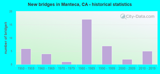
- New bridges - historical statistics
- 61950-1959
- 41960-1969
- 11970-1979
- 171980-1989
- 71990-1999
- 22000-2009
- 52010-2019

- Reconstructed bridges - Historical Statistics
- 21990-1999
- 02000-2009
- 12010-2019


- Bridge Condition - Deck
- 36.0%Good
- 28.0%Fair
- 36.0%Poor

- Bridge Condition - Superstructure
- 48.0%Good
- 48.0%Fair
- 4.0%Poor

- Bridge Condition - Substructure
- 76.0%Good
- 24.0%Fair

- Bridge Condition - Channel
- 20.0%Good
- 60.0%Satisfactory
- 20.0%Fair
Find on map >> Show street view
Structure Number: 29 0125, Location: 10-SJ-099-6.65-MTCA (Lat: 37.797239, Lng: -121.191033), Route carried "on" structure: State highway 99, Year Built: 2007, Status: Open, Structure Length: 6.40m (21.00ft), Average Daily Traffic: 66,000 (year 2016), Truck Traffic: 15%, Average Future Daily Traffic: 110,545 (year 2038), Design Load: HS 20+Mod, Features Intersected: STATE ROUTE 120
Minimum Vertical Clearance: 30+ m (98+ ft), Kilometerpoint: 6.650, Lanes on structure: 6, Lanes under structure: 8, Base Highway Network: Yes (, Subroute: 1), Owner: State Highway Agency, Approaching Roadway Width: 32.3m (106.0ft), Skew: 31 degrees, Material/Design: Prestressed concrete continuous, Design/Construction: Box Beam or Girders - Single/Spread, Number Of Spans In Main Unit: 2, Length of Maximum Span: 32.0m (105.0ft), Curb-To-Curb Width: 32.3m (106.0ft), Out-to-Out Width: 33.5m (109.9ft)
Condition: Deck: Fair, Superstructure: Good, Substructure: Good, Operating Rating: 54.1 metric tons, Method Used To Determine Operating Rating: Assigned rating based on Load Factor Design (LFD) reported in metric tons, Inventory Rating: 32.4 metric tons, Method Used To Determine Inventory Rating: Assigned rating based on Load Factor Design (LFD) reported in metric tons, Structural Evaluation: Better than present minimum criteria, Deck Geometry: Superior to present desirable criteria, Underclear: Equal to present minimum criteria, Approach Roadway Alignment: Equal to present desirable criteria, Designated Inspection Frequency: Every 24 months, Inspection Date: October 2020, Deck Structure Type: Concrete Cast-file-Place
Find on map >> Show street view
Structure Number: 29 0129, Location: 10-SJ-099-4.89 (Lat: 37.774208, Lng: -121.179225), Route carried "on" structure: County highway , Year Built: 1954, Status: Open, Structure Length: 8.60m (28.22ft), Average Daily Traffic: 2,190 (year 2009), Truck Traffic: 1%, Average Future Daily Traffic: 2,790 (year 2038), Design Load: HS 20, Features Intersected: STATE ROUTE 99, Facility Carried by Structure: AUSTIN ROAD
Minimum Vertical Clearance: 30+ m (98+ ft), Kilometerpoint: 0.000, Lanes on structure: 2, Lanes under structure: 6, Base Highway Network: Yes, Owner: State Highway Agency, Approaching Roadway Width: 10.4m (34.1ft), Skew: 4 degrees, Material/Design: Concrete continuous, Design/Construction: Box Beam or Girders - Multiple, Number Of Spans In Main Unit: 2, Number Of Approach Spans: 2, Length of Maximum Span: 24.7m (81.0ft), Curb or Sidewalk Widths: Left: 1.5m (4.9ft), Right: 0.0m, Curb-To-Curb Width: 7.6m (24.9ft), Out-to-Out Width: 10.0m (32.8ft)
Condition: Deck: Good, Superstructure: Good, Substructure: Good, Operating Rating: 56.4 metric tons, Method Used To Determine Operating Rating: Load and Resistance Factor Rating (LRFR) rating reported by rating factor(RF) method using HL-93 loadings, Inventory Rating: 40.8 metric tons, Method Used To Determine Inventory Rating: Load and Resistance Factor Rating (LRFR) rating reported by rating factor(RF) method using HL-93 loadings, Structural Evaluation: Better than present minimum criteria, Deck Geometry: High priority of replacement, Underclear: Somewhat better than minimum adequacy, Approach Roadway Alignment: Equal to present minimum criteria, Designated Inspection Frequency: Every 48 months, Inspection Date: October 2018, Deck Structure Type: Concrete Cast-file-Place, Wearing Surface/Protective System: Wearing Surface: Bituminous
Find on map >> Show street view
Structure Number: 29 0132L, Location: 10-SJ-205-R5.94 (Lat: 37.758131, Lng: -121.453447), Route carried "on" structure: Interstate 205, Year Built: 1970, Year Reconstructed: 2010, Status: Open, Structure Length: 2.93m (9.61ft), Average Daily Traffic: 47,000 (year 2009), Truck Traffic: 12%, Average Future Daily Traffic: 75,183 (year 2040), Design Load: HS 20+Mod, Features Intersected: CORRAL HOLLOW RD
Minimum Vertical Clearance: 30+ m (98+ ft), Kilometerpoint: 5.940, Lanes on structure: 3, Lanes under structure: 4, Base Highway Network: Yes (Inventory Route: 2, Subroute: 1), Owner: State Highway Agency, Approaching Roadway Width: 17.1m (56.1ft), Skew: 2 degrees, Material/Design: Prestressed concrete, Design/Construction: Box Beam or Girders - Multiple, Number Of Spans In Main Unit: 1, Length of Maximum Span: 28.7m (94.2ft), Curb-To-Curb Width: 17.1m (56.1ft), Out-to-Out Width: 17.9m (58.7ft)
Condition: Deck: Good, Superstructure: Good, Substructure: Good, Operating Rating: 45.7 metric tons, Method Used To Determine Operating Rating: Load and Resistance Factor Rating (LRFR) rating reported by rating factor(RF) method using HL-93 loadings, Inventory Rating: 20.1 metric tons, Method Used To Determine Inventory Rating: Load and Resistance Factor Rating (LRFR) rating reported by rating factor(RF) method using HL-93 loadings, Structural Evaluation: Somewhat better than minimum adequacy, Deck Geometry: Equal to present minimum criteria, Underclear: Somewhat better than minimum adequacy, Approach Roadway Alignment: Equal to present desirable criteria, Designated Inspection Frequency: Every 24 months, Inspection Date: March 2020, Deck Structure Type: Concrete Cast-file-Place, Wearing Surface/Protective System: Wearing Surface: Integral Concrete
Find on map >> Show street view
Structure Number: 29 0133, Location: 10-SJ-099-7.46-MTCA (Lat: 37.806650, Lng: -121.198519), Route carried "on" structure: County highway , Year Built: 1955, Status: Open, Structure Length: 7.50m (24.61ft), Average Daily Traffic: 5,400 (year 2009), Truck Traffic: 1%, Average Future Daily Traffic: 2,707 (year 2038), Design Load: HS 20, Features Intersected: STATE ROUTE 99, Facility Carried by Structure: COTTAGE AVE
Minimum Vertical Clearance: 30+ m (98+ ft), Kilometerpoint: 0.000, Lanes on structure: 2, Lanes under structure: 4, Owner: State Highway Agency, Approaching Roadway Width: 10.0m (32.8ft), Skew: 4 degrees, Material/Design: Concrete continuous, Design/Construction: Box Beam or Girders - Multiple, Number Of Spans In Main Unit: 2, Number Of Approach Spans: 2, Length of Maximum Span: 24.1m (79.1ft), Curb or Sidewalk Widths: Left: 1.5m (4.9ft), Right: 0.0m, Curb-To-Curb Width: 7.9m (25.9ft), Out-to-Out Width: 10.5m (34.4ft)
Condition: Deck: Poor, Superstructure: Fair, Substructure: Fair, Operating Rating: 67.1 metric tons, Method Used To Determine Operating Rating: Load and Resistance Factor Rating (LRFR) rating reported by rating factor(RF) method using HL-93 loadings, Inventory Rating: 48.3 metric tons, Method Used To Determine Inventory Rating: Load and Resistance Factor Rating (LRFR) rating reported by rating factor(RF) method using HL-93 loadings, Structural Evaluation: Somewhat better than minimum adequacy, Deck Geometry: High priority of corrective action, Underclear: High priority of corrective action, Approach Roadway Alignment: Equal to present desirable criteria, Length Of Structure Improvement: 7.50m (24.61ft), Designated Inspection Frequency: Every 24 months, Inspection Date: October 2020, Bridge Improvement Cost: $787,000, Roadway Improvement Cost: $157,000, Total Project Cost: $1,322,000 ( Estimate for 2021), Deck Structure Type: Concrete Cast-file-Place
Find on map >> Show street view
Structure Number: 29 0135, Location: 10-SJ-099-7.93-MTCA (Lat: 37.811908, Lng: -121.204972), Route carried "on" structure: County highway , Year Built: 1955, Status: Open, Structure Length: 6.97m (22.87ft), Average Daily Traffic: 6,551 (year 2012), Truck Traffic: 1%, Average Future Daily Traffic: 8,801 (year 2040), Design Load: HS 20+Mod, Features Intersected: STATE ROUTE 99, Facility Carried by Structure: LOUISE AVE
Minimum Vertical Clearance: 30+ m (98+ ft), Kilometerpoint: 0.000, Lanes on structure: 2, Lanes under structure: 4, Owner: State Highway Agency, Approaching Roadway Width: 11.0m (36.1ft), Skew: 4 degrees, Material/Design: Concrete continuous, Design/Construction: Box Beam or Girders - Multiple, Number Of Spans In Main Unit: 2, Number Of Approach Spans: 2, Length of Maximum Span: 22.5m (73.8ft), Curb or Sidewalk Widths: Left: 0.0m, Right: 1.5m (4.9ft), Curb-To-Curb Width: 6.4m (21.0ft), Out-to-Out Width: 9.9m (32.5ft)
Condition: Deck: Fair, Superstructure: Fair, Substructure: Fair, Operating Rating: 52.8 metric tons, Method Used To Determine Operating Rating: Load and Resistance Factor Rating (LRFR) rating reported by rating factor(RF) method using HL-93 loadings, Inventory Rating: 38.2 metric tons, Method Used To Determine Inventory Rating: Load and Resistance Factor Rating (LRFR) rating reported by rating factor(RF) method using HL-93 loadings, Structural Evaluation: Somewhat better than minimum adequacy, Deck Geometry: High priority of replacement, Underclear: High priority of corrective action, Approach Roadway Alignment: Equal to present desirable criteria, Designated Inspection Frequency: Every 24 months, Inspection Date: October 2020, Deck Structure Type: Concrete Cast-file-Place, Wearing Surface/Protective System: Wearing Surface: Bituminous
Find on map >> Show street view
Structure Number: 29 0271L, Location: 10-SJ-120-R1.33 (Lat: 37.789456, Lng: -121.287300), Route carried "on" structure: State highway 120, Year Built: 1980, Status: Open, Structure Length: 3.63m (11.91ft), Average Daily Traffic: 37,500 (year 2009), Truck Traffic: 19%, Average Future Daily Traffic: 55,555 (year 2039), Design Load: HS 20+Mod, Features Intersected: GUTHMILLER ROAD
Minimum Vertical Clearance: 30+ m (98+ ft), Kilometerpoint: 1.330, Lanes on structure: 2, Lanes under structure: 2, Base Highway Network: Yes (Inventory Route: 1, Subroute: 1), Owner: State Highway Agency, Approaching Roadway Width: 11.9m (39.0ft), Skew: 1 degrees, Material/Design: Prestressed concrete, Design/Construction: Box Beam or Girders - Multiple, Number Of Spans In Main Unit: 1, Length of Maximum Span: 35.9m (117.8ft), Curb-To-Curb Width: 11.7m (38.4ft), Out-to-Out Width: 12.7m (41.7ft)
Condition: Deck: Fair, Superstructure: Fair, Substructure: Good, Operating Rating: 54.1 metric tons, Method Used To Determine Operating Rating: Assigned rating based on Load Factor Design (LFD) reported in metric tons, Inventory Rating: 32.4 metric tons, Method Used To Determine Inventory Rating: Assigned rating based on Load Factor Design (LFD) reported in metric tons, Structural Evaluation: Somewhat better than minimum adequacy, Deck Geometry: Better than present minimum criteria, Underclear: Equal to present minimum criteria, Approach Roadway Alignment: Equal to present desirable criteria, Designated Inspection Frequency: Every 24 months, Inspection Date: May 2021, Deck Structure Type: Concrete Cast-file-Place
Find on map >> Show street view
Structure Number: 29 0272L, Location: 10-SJ-120-R1.81 (Lat: 37.787192, Lng: -121.278683), Route carried "on" structure: State highway 120, Year Built: 1995, Status: Open, Structure Length: 6.00m (19.69ft), Average Daily Traffic: 37,500 (year 2009), Truck Traffic: 19%, Average Future Daily Traffic: 55,555 (year 2039), Design Load: HS 20+Mod, Features Intersected: UP RR & ACE
Minimum Vertical Clearance: 30+ m (98+ ft), Kilometerpoint: 1.810, Lanes on structure: 2, Base Highway Network: Yes (Inventory Route: 1, Subroute: 1), Owner: State Highway Agency, Approaching Roadway Width: 13.1m (43.0ft), Skew: 4 degrees, Material/Design: Concrete continuous, Design/Construction: Box Beam or Girders - Multiple, Number Of Spans In Main Unit: 3, Length of Maximum Span: 25.5m (83.7ft), Curb-To-Curb Width: 12.9m (42.3ft), Out-to-Out Width: 13.9m (45.6ft)
Condition: Deck: Poor, Superstructure: Good, Substructure: Fair, Operating Rating: 54.1 metric tons, Method Used To Determine Operating Rating: Assigned rating based on Load Factor Design (LFD) reported in metric tons, Inventory Rating: 32.4 metric tons, Method Used To Determine Inventory Rating: Assigned rating based on Load Factor Design (LFD) reported in metric tons, Structural Evaluation: Somewhat better than minimum adequacy, Deck Geometry: Superior to present desirable criteria, Underclear: Superior to present desirable criteria, Approach Roadway Alignment: Equal to present desirable criteria, Designated Inspection Frequency: Every 24 months, Inspection Date: May 2021, Deck Structure Type: Concrete Cast-file-Place
Find on map >> Show street view
Structure Number: 29 0272R, Location: 10-SJ-120-R1.81 (Lat: 37.786989, Lng: -121.279278), Route carried "on" structure: State highway 120, Year Built: 1980, Status: Open, Structure Length: 5.95m (19.52ft), Average Daily Traffic: 37,500 (year 2009), Truck Traffic: 19%, Average Future Daily Traffic: 56,675 (year 2041), Design Load: HS 20+Mod, Features Intersected: UP RR & ACE
Minimum Vertical Clearance: 30+ m (98+ ft), Kilometerpoint: 1.810, Lanes on structure: 2, Base Highway Network: Yes (Inventory Route: 1, Subroute: 1), Owner: State Highway Agency, Approaching Roadway Width: 13.1m (43.0ft), Skew: 4 degrees, Material/Design: Concrete continuous, Design/Construction: Box Beam or Girders - Multiple, Number Of Spans In Main Unit: 3, Length of Maximum Span: 25.5m (83.7ft), Curb-To-Curb Width: 12.6m (41.3ft), Out-to-Out Width: 13.6m (44.6ft)
Condition: Deck: Poor, Superstructure: Fair, Substructure: Good, Operating Rating: 70.3 metric tons, Method Used To Determine Operating Rating: Load and Resistance Factor Rating (LRFR) rating reported by rating factor(RF) method using HL-93 loadings, Inventory Rating: 54.1 metric tons, Method Used To Determine Inventory Rating: Load and Resistance Factor Rating (LRFR) rating reported by rating factor(RF) method using HL-93 loadings, Structural Evaluation: Somewhat better than minimum adequacy, Deck Geometry: Better than present minimum criteria, Underclear: Equal to present minimum criteria, Approach Roadway Alignment: Equal to present desirable criteria, Length Of Structure Improvement: 5.94m (19.49ft), Designated Inspection Frequency: Every 24 months, Inspection Date: May 2021, Bridge Improvement Cost: $811,000, Roadway Improvement Cost: $162,000, Total Project Cost: $1,362,000 ( Estimate for 2018), Deck Structure Type: Concrete Cast-file-Place
Find on map >> Show street view
Structure Number: 29 0273L, Location: 10-SJ-120-R2.29 (Lat: 37.785089, Lng: -121.270714), Route carried "on" structure: State highway 120, Year Built: 1995, Status: Open, Structure Length: 3.66m (12.01ft), Average Daily Traffic: 37,500 (year 2009), Truck Traffic: 19%, Average Future Daily Traffic: 55,555 (year 2039), Design Load: HS 20+Mod, Features Intersected: MCKINLEY AVE
Minimum Vertical Clearance: 30+ m (98+ ft), Kilometerpoint: 2.290, Lanes on structure: 2, Lanes under structure: 2, Base Highway Network: Yes (Inventory Route: 1, Subroute: 1), Owner: State Highway Agency, Approaching Roadway Width: 11.9m (39.0ft), Skew: 1 degrees, Material/Design: Prestressed concrete, Design/Construction: Box Beam or Girders - Multiple, Number Of Spans In Main Unit: 1, Length of Maximum Span: 35.2m (115.5ft), Curb-To-Curb Width: 11.9m (39.0ft), Out-to-Out Width: 13.0m (42.7ft)
Condition: Deck: Poor, Superstructure: Fair, Substructure: Good, Operating Rating: 54.1 metric tons, Method Used To Determine Operating Rating: Assigned rating based on Load Factor Design (LFD) reported in metric tons, Inventory Rating: 32.4 metric tons, Method Used To Determine Inventory Rating: Assigned rating based on Load Factor Design (LFD) reported in metric tons, Structural Evaluation: Somewhat better than minimum adequacy, Deck Geometry: Better than present minimum criteria, Underclear: Equal to present minimum criteria, Approach Roadway Alignment: Equal to present desirable criteria, Designated Inspection Frequency: Every 24 months, Inspection Date: May 2021, Deck Structure Type: Concrete Cast-file-Place
Find on map >> Show street view
Structure Number: 29 0273R, Location: 10-SJ-120-R2.29 (Lat: 37.784736, Lng: -121.270706), Route carried "on" structure: State highway 120, Year Built: 1980, Status: Open, Structure Length: 3.63m (11.91ft), Average Daily Traffic: 37,500 (year 2009), Truck Traffic: 19%, Average Future Daily Traffic: 56,675 (year 2041), Design Load: HS 20+Mod, Features Intersected: MCKINLEY AVE
Minimum Vertical Clearance: 30+ m (98+ ft), Kilometerpoint: 2.290, Lanes on structure: 2, Lanes under structure: 2, Base Highway Network: Yes (Inventory Route: 1, Subroute: 1), Owner: State Highway Agency, Approaching Roadway Width: 13.4m (44.0ft), Skew: 1 degrees, Material/Design: Prestressed concrete, Design/Construction: Box Beam or Girders - Multiple, Number Of Spans In Main Unit: 1, Length of Maximum Span: 35.5m (116.5ft), Curb-To-Curb Width: 12.6m (41.3ft), Out-to-Out Width: 13.7m (44.9ft)
Condition: Deck: Poor, Superstructure: Fair, Substructure: Good, Operating Rating: 54.1 metric tons, Method Used To Determine Operating Rating: Assigned rating based on Load Factor Design (LFD) reported in metric tons, Inventory Rating: 32.4 metric tons, Method Used To Determine Inventory Rating: Assigned rating based on Load Factor Design (LFD) reported in metric tons, Structural Evaluation: Somewhat better than minimum adequacy, Deck Geometry: Better than present minimum criteria, Underclear: Equal to present minimum criteria, Approach Roadway Alignment: Equal to present desirable criteria, Designated Inspection Frequency: Every 24 months, Inspection Date: May 2021, Deck Structure Type: Concrete Cast-file-Place
Find on map >> Show street view
Structure Number: 29 0274, Location: 10-SJ-120-R3.32-MTCA (Lat: 37.783511, Lng: -121.252253), Route carried "on" structure: City street F102, Year Built: 1980, Year Reconstructed: 1995, Status: Open, Structure Length: 6.54m (21.46ft), Average Daily Traffic: 5,000 (year 2009), Truck Traffic: 5%, Average Future Daily Traffic: 6,833 (year 2039), Design Load: HS 20+Mod, Features Intersected: SR 120, Facility Carried by Structure: AIRPORT WAY
Minimum Vertical Clearance: 30+ m (98+ ft), Kilometerpoint: 0.000, Lanes on structure: 2, Lanes under structure: 4, Base Highway Network: Yes, Owner: State Highway Agency, Approaching Roadway Width: 12.2m (40.0ft), Material/Design: Prestressed concrete, Design/Construction: Box Beam or Girders - Multiple, Number Of Spans In Main Unit: 2, Length of Maximum Span: 32.5m (106.6ft), Curb-To-Curb Width: 12.2m (40.0ft), Out-to-Out Width: 13.3m (43.6ft)
Condition: Deck: Good, Superstructure: Fair, Substructure: Good, Operating Rating: 54.1 metric tons, Method Used To Determine Operating Rating: Assigned rating based on Load Factor Design (LFD) reported in metric tons, Inventory Rating: 32.4 metric tons, Method Used To Determine Inventory Rating: Assigned rating based on Load Factor Design (LFD) reported in metric tons, Structural Evaluation: Somewhat better than minimum adequacy, Deck Geometry: Equal to present minimum criteria, Underclear: Equal to present minimum criteria, Approach Roadway Alignment: Equal to present desirable criteria, Designated Inspection Frequency: Every 24 months, Inspection Date: May 2021, Deck Structure Type: Concrete Cast-file-Place
Find on map >> Show street view
Structure Number: 29 0275, Location: 10-SJ-120-R4.31-MTCA (Lat: 37.783592, Lng: -121.234131), Route carried "on" structure: City street , Year Built: 1980, Year Reconstructed: 2021, Status: Open, Structure Length: 6.54m (21.46ft), Average Daily Traffic: 5,000 (year 2009), Truck Traffic: 5%, Average Future Daily Traffic: 6,161 (year 2039), Design Load: HS 20+Mod, Features Intersected: ST RTE 120, Facility Carried by Structure: UNION ROAD
Minimum Vertical Clearance: 30+ m (98+ ft), Kilometerpoint: 0.000, Lanes on structure: 4, Lanes under structure: 4, Base Highway Network: Yes, Owner: State Highway Agency, Approaching Roadway Width: 23.3m (76.4ft), Skew: 20 degrees, Material/Design: Prestressed concrete, Design/Construction: Box Beam or Girders - Multiple, Number Of Spans In Main Unit: 2, Length of Maximum Span: 32.5m (106.6ft), Curb or Sidewalk Widths: Left: 0.0m, Right: 3.2m (10.5ft), Curb-To-Curb Width: 23.3m (76.4ft), Out-to-Out Width: 27.8m (91.2ft)
Condition: Deck: Good, Superstructure: Good, Substructure: Good, Operating Rating: 54.1 metric tons, Method Used To Determine Operating Rating: Assigned rating based on Load Factor Design (LFD) reported in metric tons, Inventory Rating: 32.4 metric tons, Method Used To Determine Inventory Rating: Assigned rating based on Load Factor Design (LFD) reported in metric tons, Structural Evaluation: Better than present minimum criteria, Deck Geometry: Superior to present desirable criteria, Underclear: Equal to present minimum criteria, Approach Roadway Alignment: Equal to present desirable criteria, Designated Inspection Frequency: Every 24 months, Inspection Date: May 2021, Deck Structure Type: Concrete Cast-file-Place
Find on map >> Show street view
Structure Number: 29 0276, Location: 10-SJ-120-R5.31-MTCA (Lat: 37.783664, Lng: -121.215894), Route carried "on" structure: City street , Year Built: 1980, Year Reconstructed: 1995, Status: Open, Structure Length: 6.54m (21.46ft), Average Daily Traffic: 7,000 (year 2009), Truck Traffic: 2%, Average Future Daily Traffic: 9,973 (year 2041), Design Load: HS 20+Mod, Features Intersected: SR 120, Facility Carried by Structure: MAIN ST
Minimum Vertical Clearance: 30+ m (98+ ft), Kilometerpoint: 0.000, Lanes on structure: 2, Lanes under structure: 4, Owner: State Highway Agency, Approaching Roadway Width: 12.2m (40.0ft), Material/Design: Prestressed concrete continuous, Design/Construction: Box Beam or Girders - Multiple, Number Of Spans In Main Unit: 2, Length of Maximum Span: 32.5m (106.6ft), Curb-To-Curb Width: 12.2m (40.0ft), Out-to-Out Width: 13.3m (43.6ft)
Condition: Deck: Good, Superstructure: Good, Substructure: Good, Operating Rating: 54.1 metric tons, Method Used To Determine Operating Rating: Assigned rating based on Load Factor Design (LFD) reported in metric tons, Inventory Rating: 32.4 metric tons, Method Used To Determine Inventory Rating: Assigned rating based on Load Factor Design (LFD) reported in metric tons, Structural Evaluation: Better than present minimum criteria, Deck Geometry: Somewhat better than minimum adequacy, Underclear: Meets minimum limits, Approach Roadway Alignment: Equal to present desirable criteria, Designated Inspection Frequency: Every 24 months, Inspection Date: May 2021, Deck Structure Type: Concrete Cast-file-Place
Find on map >> Show street view
Structure Number: 29 0277L, Location: 10-SJ-120-R6.13-MTCA (Lat: 37.783481, Lng: -121.200828), Route carried "on" structure: State highway 120, Year Built: 1995, Status: Open, Structure Length: 3.35m (10.99ft), Average Daily Traffic: 20,900 (year 2009), Truck Traffic: 19%, Average Future Daily Traffic: 47,353 (year 2039), Design Load: HS 20+Mod, Features Intersected: SPRECKLES ROAD
Minimum Vertical Clearance: 30+ m (98+ ft), Kilometerpoint: 6.130, Lanes on structure: 2, Lanes under structure: 2, Base Highway Network: Yes (Inventory Route: 1, Subroute: 1), Owner: State Highway Agency, Approaching Roadway Width: 11.9m (39.0ft), Material/Design: Prestressed concrete, Design/Construction: Box Beam or Girders - Multiple, Number Of Spans In Main Unit: 1, Length of Maximum Span: 32.1m (105.3ft), Curb-To-Curb Width: 11.9m (39.0ft), Out-to-Out Width: 13.0m (42.7ft)
Condition: Deck: Poor, Superstructure: Fair, Substructure: Good, Operating Rating: 54.1 metric tons, Method Used To Determine Operating Rating: Assigned rating based on Load Factor Design (LFD) reported in metric tons, Inventory Rating: 32.4 metric tons, Method Used To Determine Inventory Rating: Assigned rating based on Load Factor Design (LFD) reported in metric tons, Structural Evaluation: Somewhat better than minimum adequacy, Deck Geometry: Equal to present minimum criteria, Underclear: Superior to present desirable criteria, Approach Roadway Alignment: Equal to present desirable criteria, Designated Inspection Frequency: Every 24 months, Inspection Date: May 2021, Deck Structure Type: Concrete Cast-file-Place
Find on map >> Show street view
Structure Number: 29 0277R, Location: 10-SJ-120-R6.13-MTCA (Lat: 37.783144, Lng: -121.200814), Route carried "on" structure: State highway 120, Year Built: 1980, Status: Open, Structure Length: 3.32m (10.89ft), Average Daily Traffic: 20,900 (year 2009), Truck Traffic: 19%, Average Future Daily Traffic: 49,282 (year 2043), Design Load: HS 20+Mod, Features Intersected: SPRECKLES ROAD
Minimum Vertical Clearance: 30+ m (98+ ft), Kilometerpoint: 6.130, Lanes on structure: 2, Lanes under structure: 2, Base Highway Network: Yes (Inventory Route: 1, Subroute: 1), Owner: State Highway Agency, Approaching Roadway Width: 12.8m (42.0ft), Material/Design: Prestressed concrete, Design/Construction: Box Beam or Girders - Multiple, Number Of Spans In Main Unit: 1, Length of Maximum Span: 32.9m (107.9ft), Curb-To-Curb Width: 12.6m (41.3ft), Out-to-Out Width: 13.6m (44.6ft)
Condition: Deck: Fair, Superstructure: Fair, Substructure: Good, Operating Rating: 54.1 metric tons, Method Used To Determine Operating Rating: Assigned rating based on Load Factor Design (LFD) reported in metric tons, Inventory Rating: 32.4 metric tons, Method Used To Determine Inventory Rating: Assigned rating based on Load Factor Design (LFD) reported in metric tons, Structural Evaluation: Somewhat better than minimum adequacy, Deck Geometry: Better than present minimum criteria, Underclear: Somewhat better than minimum adequacy, Approach Roadway Alignment: Equal to present desirable criteria, Designated Inspection Frequency: Every 24 months, Inspection Date: May 2021, Deck Structure Type: Concrete Cast-file-Place
Find on map >> Show street view
Structure Number: 29 0278L, Location: 10-SJ-120-R6.33 (Lat: 37.783139, Lng: -121.196592), Route carried "on" structure: State highway 120, Year Built: 1995, Status: Open, Structure Length: 15.12m (49.61ft), Average Daily Traffic: 20,900 (year 2009), Truck Traffic: 15%, Average Future Daily Traffic: 32,991 (year 2039), Design Load: HS 20+Mod, Features Intersected: UP RR & MOFFAT BLVD
Minimum Vertical Clearance: 30+ m (98+ ft), Kilometerpoint: 6.330, Lanes on structure: 2, Lanes under structure: 2, Base Highway Network: Yes (Inventory Route: 1, Subroute: 1), Owner: State Highway Agency, Approaching Roadway Width: 11.9m (39.0ft), Material/Design: Prestressed concrete continuous, Design/Construction: Box Beam or Girders - Multiple, Number Of Spans In Main Unit: 3, Length of Maximum Span: 56.4m (185.0ft), Curb-To-Curb Width: 11.9m (39.0ft), Out-to-Out Width: 13.0m (42.7ft)
Condition: Deck: Poor, Superstructure: Good, Substructure: Good, Operating Rating: 54.1 metric tons, Method Used To Determine Operating Rating: Assigned rating based on Load Factor Design (LFD) reported in metric tons, Inventory Rating: 32.4 metric tons, Method Used To Determine Inventory Rating: Assigned rating based on Load Factor Design (LFD) reported in metric tons, Structural Evaluation: Better than present minimum criteria, Deck Geometry: Equal to present minimum criteria, Underclear: Meets minimum limits, Approach Roadway Alignment: Equal to present desirable criteria, Designated Inspection Frequency: Every 24 months, Inspection Date: May 2021, Deck Structure Type: Concrete Cast-file-Place
Find on map >> Show street view
Structure Number: 29 0278R, Location: 10-SJ-120-R6.36 (Lat: 37.783475, Lng: -121.197239), Route carried "on" structure: State highway 120, Year Built: 1980, Status: Open, Structure Length: 11.84m (38.85ft), Average Daily Traffic: 20,900 (year 2009), Truck Traffic: 15%, Average Future Daily Traffic: 34,335 (year 2043), Design Load: HS 20+Mod, Features Intersected: UP RR & MOFFAT BLVD
Minimum Vertical Clearance: 30+ m (98+ ft), Kilometerpoint: 6.360, Lanes on structure: 2, Lanes under structure: 2, Base Highway Network: Yes (Inventory Route: 1, Subroute: 1), Owner: State Highway Agency, Approaching Roadway Width: 13.1m (43.0ft), Skew: 5 degrees, Material/Design: Prestressed concrete continuous, Design/Construction: Box Beam or Girders - Multiple, Number Of Spans In Main Unit: 2, Length of Maximum Span: 59.2m (194.2ft), Curb-To-Curb Width: 12.6m (41.3ft), Out-to-Out Width: 13.6m (44.6ft)
Condition: Deck: Fair, Superstructure: Fair, Substructure: Good, Operating Rating: 54.1 metric tons, Method Used To Determine Operating Rating: Assigned rating based on Load Factor Design (LFD) reported in metric tons, Inventory Rating: 32.4 metric tons, Method Used To Determine Inventory Rating: Assigned rating based on Load Factor Design (LFD) reported in metric tons, Structural Evaluation: Somewhat better than minimum adequacy, Deck Geometry: Better than present minimum criteria, Underclear: Superior to present desirable criteria, Approach Roadway Alignment: Equal to present desirable criteria, Designated Inspection Frequency: Every 24 months, Inspection Date: May 2021, Deck Structure Type: Concrete Cast-file-Place
Find on map >> Show street view
Structure Number: 29 0286E, Location: 10-SJ-120-6.86 (Lat: 37.785261, Lng: -121.188439), Route carried "on" structure: Ramp State highway 120, Year Built: 1980, Status: Open, Structure Length: 5.40m (17.72ft), Average Daily Traffic: 26,000 (year 2009), Truck Traffic: 18%, Average Future Daily Traffic: 40,212 (year 2039), Design Load: HS 20+Mod, Features Intersected: STATE ROUTE 99
Minimum Vertical Clearance: 5.18m (16.99ft), Kilometerpoint: 6.860, Lanes on structure: 2, Lanes under structure: 6, Base Highway Network: Yes (Inventory Route: 1, Subroute: 1), Owner: State Highway Agency, Approaching Roadway Width: 12.8m (42.0ft), Skew: 30 degrees, Material/Design: Concrete continuous, Design/Construction: Box Beam or Girders - Multiple, Number Of Spans In Main Unit: 2, Length of Maximum Span: 27.4m (89.9ft), Curb-To-Curb Width: 11.6m (38.1ft), Out-to-Out Width: 13.3m (43.6ft)
Condition: Deck: Poor, Superstructure: Fair, Substructure: Fair, Operating Rating: 40.5 metric tons, Method Used To Determine Operating Rating: Load and Resistance Factor Rating (LRFR) rating reported by rating factor(RF) method using HL-93 loadings, Inventory Rating: 31.4 metric tons, Method Used To Determine Inventory Rating: Load and Resistance Factor Rating (LRFR) rating reported by rating factor(RF) method using HL-93 loadings, Structural Evaluation: Somewhat better than minimum adequacy, Deck Geometry: Superior to present desirable criteria, Underclear: Equal to present minimum criteria, Approach Roadway Alignment: Somewhat better than minimum adequacy, Designated Inspection Frequency: Every 24 months, Inspection Date: May 2021, Deck Structure Type: Concrete Cast-file-Place
Find on map >> Show street view
Structure Number: 29 033, Location: 10-SJ-099-17.41-STKN (Lat: 37.944392, Lng: -121.235761), Route carried "on" structure: City street , Year Built: 2016, Status: Open, Structure Length: 10.62m (34.84ft), Average Daily Traffic: 11,700 (year 2015), Truck Traffic: 2%, Average Future Daily Traffic: 20,471 (year 2042), Design Load: HL 93, Features Intersected: HWY 99, Facility Carried by Structure: GOLDEN GATE AVE
Minimum Vertical Clearance: 30+ m (98+ ft), Kilometerpoint: 0.000, Lanes on structure: 5, Lanes under structure: 7, Owner: State Highway Agency, Approaching Roadway Width: 23.1m (75.8ft), Skew: 4 degrees, Material/Design: Prestressed concrete continuous, Design/Construction: Box Beam or Girders - Multiple, Number Of Spans In Main Unit: 3, Length of Maximum Span: 37.5m (123.0ft), Curb or Sidewalk Widths: Left: 1.5m (4.9ft), Right: 1.5m (4.9ft), Curb-To-Curb Width: 23.1m (75.8ft), Out-to-Out Width: 26.8m (87.9ft)
Condition: Deck: Good, Superstructure: Good, Substructure: Fair, Operating Rating: 42.1 metric tons, Method Used To Determine Operating Rating: Assigned ratings based on Load and Resistance Factor Design (LRFD) reported by rating factor (RF) using HL93 loadings, Inventory Rating: 32.4 metric tons, Method Used To Determine Inventory Rating: Assigned ratings based on Load and Resistance Factor Design (LRFD) reported by rating factor (RF) using HL93 loadings, Structural Evaluation: Somewhat better than minimum adequacy, Deck Geometry: Better than present minimum criteria, Underclear: Somewhat better than minimum adequacy, Approach Roadway Alignment: Equal to present desirable criteria, Designated Inspection Frequency: Every 24 months, Inspection Date: June 2020, Deck Structure Type: Concrete Cast-file-Place
Find on map >> Show street view
Structure Number: 29 0331, Location: 10-SJ-099-9.18-MTCA (Lat: 37.826528, Lng: -121.217750), Route carried "on" structure: City street , Year Built: 2015, Status: Open, Structure Length: 8.53m (27.99ft), Average Daily Traffic: 6,000 (year 2015), Truck Traffic: 15%, Average Future Daily Traffic: 8,700 (year 2042), Design Load: HL 93, Features Intersected: STATE ROUTE 99, Facility Carried by Structure: LATHROP ROAD
Minimum Vertical Clearance: 30+ m (98+ ft), Kilometerpoint: 0.000, Lanes on structure: 6, Lanes under structure: 8, Base Highway Network: Yes, Owner: State Highway Agency, Approaching Roadway Width: 26.8m (87.9ft), Material/Design: Prestressed concrete continuous, Design/Construction: Box Beam or Girders - Multiple, Number Of Spans In Main Unit: 2, Length of Maximum Span: 42.7m (140.1ft), Curb or Sidewalk Widths: Left: 2.4m (7.9ft), Right: 0.0m, Curb-To-Curb Width: 26.8m (87.9ft), Out-to-Out Width: 30.0m (98.4ft)
Condition: Deck: Good, Superstructure: Good, Substructure: Good, Operating Rating: 42.1 metric tons, Method Used To Determine Operating Rating: Assigned ratings based on Load and Resistance Factor Design (LRFD) reported by rating factor (RF) using HL93 loadings, Inventory Rating: 32.4 metric tons, Method Used To Determine Inventory Rating: Assigned ratings based on Load and Resistance Factor Design (LRFD) reported by rating factor (RF) using HL93 loadings, Structural Evaluation: Better than present minimum criteria, Deck Geometry: Better than present minimum criteria, Underclear: Equal to present minimum criteria, Approach Roadway Alignment: Equal to present desirable criteria, Designated Inspection Frequency: Every 24 months, Inspection Date: October 2020, Deck Structure Type: Concrete Cast-file-Place
Find on map >> Show street view
Structure Number: 29 0332, Location: 10-SJ-099-11.47-MTCA (Lat: 37.859664, Lng: -121.218922), Route carried "on" structure: State highway 99, Year Built: 2015, Status: Open, Structure Length: 7.38m (24.21ft), Average Daily Traffic: 70,500 (year 2009), Truck Traffic: 17%, Average Future Daily Traffic: 94,146 (year 2043), Design Load: HL 93, Features Intersected: UP RR & FRENCH CAMP ROAD
Minimum Vertical Clearance: 30+ m (98+ ft), Kilometerpoint: 11.470, Lanes on structure: 8, Lanes under structure: 2, Base Highway Network: Yes (, Subroute: 1), Owner: State Highway Agency, Approaching Roadway Width: 42.2m (138.5ft), Skew: 32 degrees, Material/Design: Prestressed concrete continuous, Design/Construction: Box Beam or Girders - Multiple, Number Of Spans In Main Unit: 2, Length of Maximum Span: 36.2m (118.8ft), Curb-To-Curb Width: 42.2m (138.5ft), Out-to-Out Width: 44.1m (144.7ft)
Condition: Deck: Fair, Superstructure: Good, Substructure: Fair, Operating Rating: 42.1 metric tons, Method Used To Determine Operating Rating: Assigned ratings based on Load and Resistance Factor Design (LRFD) reported by rating factor (RF) using HL93 loadings, Inventory Rating: 32.4 metric tons, Method Used To Determine Inventory Rating: Assigned ratings based on Load and Resistance Factor Design (LRFD) reported by rating factor (RF) using HL93 loadings, Structural Evaluation: Somewhat better than minimum adequacy, Deck Geometry: Superior to present desirable criteria, Underclear: Equal to present minimum criteria, Approach Roadway Alignment: Equal to present desirable criteria, Designated Inspection Frequency: Every 24 months, Inspection Date: May 2021, Deck Structure Type: Concrete Cast-file-Place
Find on map >> Show street view
Structure Number: 29C0076, Location: 0.7 MI N LONE TREE RD (Lat: 37.837403, Lng: -121.144714), Route carried "on" structure: County highway , Year Built: 1962, Status: Open, Structure Length: 1.77m (5.81ft), Average Daily Traffic: 3,015 (year 2013), Truck Traffic: 5%, Average Future Daily Traffic: 2,734 (year 2042), Design Load: HS 20, Features Intersected: LONE TREE CREEK, Facility Carried by Structure: JACK TONE ROAD
Minimum Vertical Clearance: 30+ m (98+ ft), Kilometerpoint: 0.000, Lanes on structure: 2, Owner: County Highway Agency, Approaching Roadway Width: 10.1m (33.1ft), Material/Design: Concrete continuous, Design/Construction: Slab, Number Of Spans In Main Unit: 2, Length of Maximum Span: 8.5m (27.9ft), Curb-To-Curb Width: 9.8m (32.2ft), Out-to-Out Width: 10.0m (32.8ft)
Condition: Deck: Fair, Superstructure: Fair, Substructure: Good, Channel: Satisfactory, Operating Rating: 56.7 metric tons, Method Used To Determine Operating Rating: Load Factor (LF), Inventory Rating: 34.0 metric tons, Method Used To Determine Inventory Rating: Load Factor (LF), Structural Evaluation: Somewhat better than minimum adequacy, Deck Geometry: Meets minimum limits, Waterway Adequacy: Equal to present desirable criteria, Approach Roadway Alignment: Equal to present desirable criteria, Designated Inspection Frequency: Every 24 months, Inspection Date: September 2020, Deck Structure Type: Concrete Cast-file-Place
Find on map >> Show street view
Structure Number: 29C0158, Location: 1.2 MI N LONE TREE RD (Lat: 37.844189, Lng: -121.145022), Route carried "on" structure: County highway , Year Built: 1962, Status: Open, Structure Length: 0.79m (2.59ft), Average Daily Traffic: 1,761 (year 2013), Truck Traffic: 5%, Average Future Daily Traffic: 2,663 (year 2037), Design Load: H 20, Features Intersected: LONE TREE CREEK, Facility Carried by Structure: JACK TONE ROAD
Minimum Vertical Clearance: 30+ m (98+ ft), Kilometerpoint: 0.000, Lanes on structure: 2, Owner: County Highway Agency, Approaching Roadway Width: 10.0m (32.8ft), Material/Design: Concrete continuous, Design/Construction: Culvert, Number Of Spans In Main Unit: 3, Length of Maximum Span: 2.4m (7.9ft), Curb-To-Curb Width: 10.0m (32.8ft), Out-to-Out Width: 10.6m (34.8ft)
Condition: Channel: Satisfactory, Culverts: Satisfactory, Operating Rating: 40.5 metric tons, Method Used To Determine Operating Rating: Field evaluation and documented engineering judgment, Inventory Rating: 24.3 metric tons, Method Used To Determine Inventory Rating: Field evaluation and documented engineering judgment, Structural Evaluation: Equal to present minimum criteria, Deck Geometry: Somewhat better than minimum adequacy, Waterway Adequacy: Equal to present minimum criteria, Approach Roadway Alignment: Equal to present desirable criteria, Designated Inspection Frequency: Every 24 months, Inspection Date: September 2020, Deck Structure Type: Concrete Cast-file-Place, Wearing Surface/Protective System: Wearing Surface: Bituminous
Find on map >> Show street view
Structure Number: 29C0159, Location: 1.9 MI N. LONE TREE RD (Lat: 37.853478, Lng: -121.145458), Route carried "on" structure: County highway , Year Built: 1962, Status: Open, Structure Length: 1.77m (5.81ft), Average Daily Traffic: 1,761 (year 2017), Truck Traffic: 5%, Average Future Daily Traffic: 1,594 (year 2038), Design Load: HS 20, Features Intersected: TEMPLE CREEK, Facility Carried by Structure: JACK TONE ROAD
Minimum Vertical Clearance: 30+ m (98+ ft), Kilometerpoint: 0.000, Lanes on structure: 2, Owner: County Highway Agency, Approaching Roadway Width: 9.8m (32.2ft), Material/Design: Concrete continuous, Design/Construction: Slab, Number Of Spans In Main Unit: 2, Length of Maximum Span: 8.2m (26.9ft), Curb-To-Curb Width: 9.8m (32.2ft), Out-to-Out Width: 9.9m (32.5ft)
Condition: Deck: Poor, Superstructure: Poor, Substructure: Good, Channel: Good, Operating Rating: 56.7 metric tons, Method Used To Determine Operating Rating: Load Factor (LF), Inventory Rating: 34.0 metric tons, Method Used To Determine Inventory Rating: Load Factor (LF), Structural Evaluation: Meets minimum limits, Deck Geometry: Somewhat better than minimum adequacy, Waterway Adequacy: Equal to present desirable criteria, Approach Roadway Alignment: Equal to present desirable criteria, Length Of Structure Improvement: 1.77m (5.81ft), Designated Inspection Frequency: Every 24 months, Inspection Date: January 2021, Bridge Improvement Cost: $176,000, Roadway Improvement Cost: $35,000, Total Project Cost: $295,000 ( Estimate for 2017), Deck Structure Type: Concrete Cast-file-Place
Find on map >> Show street view
Structure Number: 29C0284, Location: 0.4 MI E OF OAK STREET (Lat: 37.770433, Lng: -121.292303), Route carried "on" structure: County highway , Year Built: 1988, Status: Open, Structure Length: 2.97m (9.74ft), Average Daily Traffic: 398 (year 2013), Truck Traffic: 10%, Average Future Daily Traffic: 712 (year 2042), Design Load: HS 20+Mod, Features Intersected: WALTHALL SLOUGH, Facility Carried by Structure: WILLIAMSON RD
Minimum Vertical Clearance: 30+ m (98+ ft), Kilometerpoint: 0.000, Lanes on structure: 2, Owner: County Highway Agency, Approaching Roadway Width: 6.7m (22.0ft), Material/Design: Concrete continuous, Design/Construction: Slab, Number Of Spans In Main Unit: 3, Length of Maximum Span: 11.6m (38.1ft), Curb-To-Curb Width: 9.1m (29.9ft), Out-to-Out Width: 9.5m (31.2ft)
Condition: Deck: Good, Superstructure: Good, Substructure: Good, Channel: Satisfactory, Operating Rating: 54.1 metric tons, Method Used To Determine Operating Rating: Assigned rating based on Load Factor Design (LFD) reported in metric tons, Inventory Rating: 32.4 metric tons, Method Used To Determine Inventory Rating: Assigned rating based on Load Factor Design (LFD) reported in metric tons, Structural Evaluation: Better than present minimum criteria, Deck Geometry: Equal to present minimum criteria, Waterway Adequacy: Superior to present desirable criteria, Approach Roadway Alignment: Equal to present desirable criteria, Designated Inspection Frequency: Every 48 months, Inspection Date: September 2020, Deck Structure Type: Concrete Cast-file-Place
Find on map >> Show street view
Structure Number: 29C0355, Location: 0.6 MI N OF FRENCH CAMP (Lat: 37.855531, Lng: -121.185233), Route carried "on" structure: County highway , Year Built: 1969, Status: Open, Structure Length: 1.77m (5.81ft), Average Daily Traffic: 442 (year 2013), Truck Traffic: 5%, Average Future Daily Traffic: 653 (year 2040), Design Load: HS 20, Features Intersected: LONE TREE CREEK, Facility Carried by Structure: AUSTIN ROAD
Minimum Vertical Clearance: 30+ m (98+ ft), Kilometerpoint: 0.000, Lanes on structure: 2, Owner: County Highway Agency, Approaching Roadway Width: 9.8m (32.2ft), Skew: 3 degrees, Material/Design: Concrete continuous, Design/Construction: Slab, Number Of Spans In Main Unit: 2, Length of Maximum Span: 8.5m (27.9ft), Curb-To-Curb Width: 9.8m (32.2ft), Out-to-Out Width: 10.3m (33.8ft)
Condition: Deck: Good, Superstructure: Good, Substructure: Good, Channel: Fair, Operating Rating: 54.1 metric tons, Method Used To Determine Operating Rating: Load Factor (LF), Inventory Rating: 32.4 metric tons, Method Used To Determine Inventory Rating: Load Factor (LF), Structural Evaluation: Better than present minimum criteria, Deck Geometry: Equal to present minimum criteria, Waterway Adequacy: Equal to present desirable criteria, Approach Roadway Alignment: Equal to present minimum criteria, Designated Inspection Frequency: Every 24 months, Inspection Date: September 2020, Deck Structure Type: Concrete Cast-file-Place, Wearing Surface/Protective System: Wearing Surface: Bituminous
Find on map >> Show street view
Structure Number: 29 0125, Location: 10-SJ-099-6.65-MTCA (Lat: 37.797239, Lng: -121.191033), Route carried "under" structure: State highway 120, Year Built: 2007, Structure Length: 0. m, Average Daily Traffic: 14,100 (year 2009), Truck Traffic: 15%, Features Intersected: STATE ROUTE 120, Facility Carried by Structure: STATE ROUTE 99
Minimum Vertical Clearance: 4.82m (15.81ft), Kilometerpoint: 6.200, Lanes on structure: 6, Lanes under structure: 8, Material/Design: Prestressed concrete continuous, Design/Construction: Box Beam or Girders - Single/Spread, Length of Maximum Span: 32.0m (105.0ft)
Find on map >> Show street view
Structure Number: 29 0129, Location: 10-SJ-099-4.89 (Lat: 37.774208, Lng: -121.179225), Route carried "under" structure: State highway 99, Year Built: 1954, Structure Length: 0. m, Average Daily Traffic: 105,500 (year 2009), Truck Traffic: 20%, Features Intersected: STATE ROUTE 99, Facility Carried by Structure: AUSTIN ROAD
Minimum Vertical Clearance: 4.65m (15.26ft), Kilometerpoint: 4.890, Lanes on structure: 2, Lanes under structure: 6, Material/Design: Concrete continuous, Design/Construction: Box Beam or Girders - Multiple, Length of Maximum Span: 24.7m (81.0ft)
Find on map >> Show street view
Structure Number: 29 0133, Location: 10-SJ-099-7.46-MTCA (Lat: 37.806650, Lng: -121.198519), Route carried "under" structure: State highway 99, Year Built: 1955, Structure Length: 0. m, Average Daily Traffic: 66,000 (year 2009), Truck Traffic: 15%, Features Intersected: STATE ROUTE 99, Facility Carried by Structure: COTTAGE AVE
Minimum Vertical Clearance: 4.45m (14.60ft), Kilometerpoint: 7.460, Lanes on structure: 2, Lanes under structure: 4, Material/Design: Concrete continuous, Design/Construction: Box Beam or Girders - Multiple, Length of Maximum Span: 24.1m (79.1ft)
Find on map >> Show street view
Structure Number: 29 0135, Location: 10-SJ-099-7.93-MTCA (Lat: 37.811908, Lng: -121.204972), Route carried "under" structure: State highway 99, Year Built: 1955, Structure Length: 0. m, Average Daily Traffic: 86,000 (year 2009), Truck Traffic: 21%, Features Intersected: STATE ROUTE 99, Facility Carried by Structure: LOUISE AVE
Minimum Vertical Clearance: 4.49m (14.73ft), Kilometerpoint: 7.930, Lanes on structure: 2, Lanes under structure: 4, Material/Design: Concrete continuous, Design/Construction: Box Beam or Girders - Multiple, Length of Maximum Span: 22.5m (73.8ft)
Find on map >> Show street view
Structure Number: 29 0273L, Location: 10-SJ-120-R2.29 (Lat: 37.785089, Lng: -121.270714), Route carried "under" structure: County highway , Year Built: 1995, Structure Length: 0. m, Average Daily Traffic: 1,782 (year 2010), Truck Traffic: 3%, Features Intersected: MCKINLEY AVE, Facility Carried by Structure: SR 120 WB
Minimum Vertical Clearance: 4.67m (15.32ft), Kilometerpoint: 0.000, Lanes on structure: 2, Lanes under structure: 2, Material/Design: Prestressed concrete, Design/Construction: Box Beam or Girders - Multiple, Length of Maximum Span: 35.2m (115.5ft)
Find on map >> Show street view
Structure Number: 29 0273R, Location: 10-SJ-120-R2.29 (Lat: 37.784736, Lng: -121.270706), Route carried "under" structure: County highway , Year Built: 1980, Structure Length: 0. m, Average Daily Traffic: 1,782 (year 2010), Truck Traffic: 3%, Features Intersected: MCKINLEY AVE, Facility Carried by Structure: SR 120 EB
Minimum Vertical Clearance: 4.67m (15.32ft), Kilometerpoint: 0.000, Lanes on structure: 2, Lanes under structure: 2, Material/Design: Prestressed concrete, Design/Construction: Box Beam or Girders - Multiple, Length of Maximum Span: 35.5m (116.5ft)
Find on map >> Show street view
Structure Number: 29 0274, Location: 10-SJ-120-R3.32-MTCA (Lat: 37.783511, Lng: -121.252253), Route carried "under" structure: State highway 120, Year Built: 1980, Structure Length: 0. m, Average Daily Traffic: 68,000 (year 2009), Truck Traffic: 19%, Features Intersected: SR 120, Facility Carried by Structure: AIRPORT WAY
Minimum Vertical Clearance: 5.13m (16.83ft), Kilometerpoint: 3.320, Lanes on structure: 2, Lanes under structure: 4, Material/Design: Prestressed concrete, Design/Construction: Box Beam or Girders - Multiple, Length of Maximum Span: 32.5m (106.6ft)
Find on map >> Show street view
Structure Number: 29 0275, Location: 10-SJ-120-R4.31-MTCA (Lat: 37.783592, Lng: -121.234131), Route carried "under" structure: State highway 120, Year Built: 1980, Structure Length: 0. m, Average Daily Traffic: 68,000 (year 2009), Truck Traffic: 19%, Features Intersected: ST RTE 120, Facility Carried by Structure: UNION ROAD
Minimum Vertical Clearance: 5.08m (16.67ft), Kilometerpoint: 4.310, Lanes on structure: 4, Lanes under structure: 4, Material/Design: Prestressed concrete, Design/Construction: Box Beam or Girders - Multiple, Length of Maximum Span: 32.5m (106.6ft)
Find on map >> Show street view
Structure Number: 29 0276, Location: 10-SJ-120-R5.31-MTCA (Lat: 37.783664, Lng: -121.215894), Route carried "under" structure: State highway 120, Year Built: 1980, Structure Length: 0. m, Average Daily Traffic: 72,000 (year 2009), Truck Traffic: 19%, Features Intersected: SR 120, Facility Carried by Structure: MAIN ST
Minimum Vertical Clearance: 4.90m (16.08ft), Kilometerpoint: 5.310, Lanes on structure: 2, Lanes under structure: 4, Material/Design: Prestressed concrete continuous, Design/Construction: Box Beam or Girders - Multiple, Length of Maximum Span: 32.5m (106.6ft)
Find on map >> Show street view
Structure Number: 29 0277L, Location: 10-SJ-120-R6.13-MTCA (Lat: 37.783481, Lng: -121.200828), Route carried "under" structure: City street , Year Built: 1995, Structure Length: 0. m, Average Daily Traffic: 1,165 (year 2017), Truck Traffic: 3%, Features Intersected: SPRECKLES ROAD, Facility Carried by Structure: SR 120 WB
Minimum Vertical Clearance: 5.30m (17.39ft), Kilometerpoint: 0.000, Lanes on structure: 2, Lanes under structure: 2, Material/Design: Prestressed concrete, Design/Construction: Box Beam or Girders - Multiple, Length of Maximum Span: 32.1m (105.3ft)
Find on map >> Show street view
Structure Number: 29 0277R, Location: 10-SJ-120-R6.13-MTCA (Lat: 37.783144, Lng: -121.200814), Route carried "under" structure: City street , Year Built: 1980, Structure Length: 0. m, Average Daily Traffic: 1,165 (year 2017), Truck Traffic: 3%, Features Intersected: SPRECKLES ROAD, Facility Carried by Structure: SR 120 EB
Minimum Vertical Clearance: 5.61m (18.41ft), Kilometerpoint: 0.000, Lanes on structure: 2, Lanes under structure: 2, Material/Design: Prestressed concrete, Design/Construction: Box Beam or Girders - Multiple, Length of Maximum Span: 32.9m (107.9ft)
Find on map >> Show street view
Structure Number: 29 0278L, Location: 10-SJ-120-R6.33 (Lat: 37.783139, Lng: -121.196592), Route carried "under" structure: County highway , Year Built: 1995, Structure Length: 0. m, Average Daily Traffic: 5,400 (year 2010), Truck Traffic: 3%, Features Intersected: UP RR & MOFFAT BLVD, Facility Carried by Structure: SR 120 WB
Minimum Vertical Clearance: 7.67m (25.16ft), Kilometerpoint: 0.000, Lanes on structure: 2, Lanes under structure: 2, Material/Design: Prestressed concrete continuous, Design/Construction: Box Beam or Girders - Multiple, Length of Maximum Span: 56.4m (185.0ft)
Find on map >> Show street view
Structure Number: 29 0278R, Location: 10-SJ-120-R6.36 (Lat: 37.783475, Lng: -121.197239), Route carried "under" structure: City street , Year Built: 1980, Structure Length: 0. m, Average Daily Traffic: 5,400 (year 2010), Truck Traffic: 3%, Features Intersected: UP RR & MOFFAT BLVD, Facility Carried by Structure: SR 120 EB
Minimum Vertical Clearance: 7.79m (25.56ft), Kilometerpoint: 0.000, Lanes on structure: 2, Lanes under structure: 2, Material/Design: Prestressed concrete continuous, Design/Construction: Box Beam or Girders - Multiple, Length of Maximum Span: 59.2m (194.2ft)
Find on map >> Show street view
Structure Number: 29 0286E, Location: 10-SJ-120-6.86 (Lat: 37.785261, Lng: -121.188439), Route carried "under" structure: State highway 99, Year Built: 1980, Structure Length: 0. m, Average Daily Traffic: 83,000 (year 2009), Truck Traffic: 25%, Features Intersected: STATE ROUTE 99
Minimum Vertical Clearance: 5.23m (17.16ft), Kilometerpoint: 5.820, Lanes on structure: 2, Lanes under structure: 6, Material/Design: Concrete continuous, Design/Construction: Box Beam or Girders - Multiple, Length of Maximum Span: 27.4m (89.9ft)
Find on map >> Show street view
Structure Number: 29 0331, Location: 10-SJ-099-9.18-MTCA (Lat: 37.826528, Lng: -121.217750), Route carried "under" structure: State highway 99, Year Built: 2015, Structure Length: 0. m, Average Daily Traffic: 67,000 (year 2009), Truck Traffic: 25%, Features Intersected: STATE ROUTE 99, Facility Carried by Structure: LATHROP ROAD
Minimum Vertical Clearance: 5.35m (17.55ft), Kilometerpoint: 9.180, Lanes on structure: 6, Lanes under structure: 8, Material/Design: Prestressed concrete continuous, Design/Construction: Box Beam or Girders - Multiple, Length of Maximum Span: 42.7m (140.1ft)
Find on map >> Show street view
Structure Number: 29 0332, Location: 10-SJ-099-11.47-MTCA (Lat: 37.859664, Lng: -121.218922), Route carried "under" structure: County highway , Year Built: 2015, Structure Length: 0. m, Average Daily Traffic: 2,000 (year 2015), Truck Traffic: 5%, Features Intersected: UP RR & FRENCH CAMP ROAD, Facility Carried by Structure: STATE ROUTE 99
Minimum Vertical Clearance: 7.23m (23.72ft), Kilometerpoint: 0.000, Lanes on structure: 8, Lanes under structure: 2, Material/Design: Prestressed concrete continuous, Design/Construction: Box Beam or Girders - Multiple, Length of Maximum Span: 36.2m (118.8ft)