Bridge Statistics for Malibu, California (CA)
Condition, Traffic, Stress, Structural Evaluation, Project Costs
- National Bridge Inventory (NBI) Statistics
- 17Number of bridges
- 138ft / 41.6mTotal length
- $2,930,000Total costs
- 355,323Total average daily traffic
- 8,355Total average daily truck traffic
- 435,091Total future (year 2027) average daily traffic
- National Bridge Inventory (NBI) Registered Bridges for Malibu
- No street view available for this location
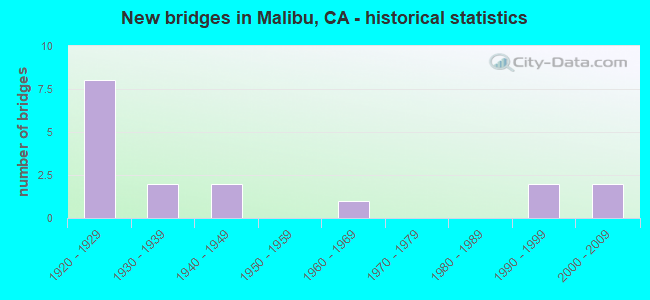
- New bridges - historical statistics
- 81920-1929
- 21930-1939
- 21940-1949
- 11960-1969
- 21990-1999
- 22000-2009

- Reconstructed bridges - Historical Statistics
- 11920-1929
- 51930-1939
- 21940-1949
- 01950-1959
- 01960-1969
- 01970-1979
- 11980-1989


- Bridge Condition - Superstructure
- 6.3%Very good
- 75.0%Good
- 6.3%Satisfactory
- 12.5%Fair

- Bridge Condition - Substructure
- 6.3%Very good
- 87.5%Good
- 6.3%Critical

- Bridge Condition - Channel
- 5.9%Excellent
- 17.6%Very good
- 47.1%Good
- 17.6%Satisfactory
- 5.9%Fair
- 5.9%Poor
Find on map >> Show street view
Structure Number: 52 0012, Location: 07-VEN-001-1.23 (Lat: 34.053647, Lng: -118.964228), Route carried "on" structure: State highway 1, Year Built: 1928, Year Reconstructed: 1935, Status: Open, Structure Length: 0.67m (2.20ft), Average Daily Traffic: 11,600 (year 2020), Truck Traffic: 3%, Average Future Daily Traffic: 15,294 (year 2042), Design Load: H 15, Features Intersected: LITTLE SYCAMORE CREEK
Minimum Vertical Clearance: 30+ m (98+ ft), Kilometerpoint: 1.230, Lanes on structure: 3, Base Highway Network: Yes (, Subroute: 1), Owner: State Highway Agency, Approaching Roadway Width: 18.0m (59.1ft), Skew: 20 degrees, Material/Design: Concrete, Design/Construction: Tee Beam, Number Of Spans In Main Unit: 1, Length of Maximum Span: 6.1m (20.0ft), Curb-To-Curb Width: 19.3m (63.3ft), Out-to-Out Width: 20.4m (66.9ft)
Condition: Deck: Good, Superstructure: Fair, Substructure: Good, Channel: Satisfactory, Operating Rating: 25.9 metric tons, Method Used To Determine Operating Rating: Load and Resistance Factor Rating (LRFR) rating reported by rating factor(RF) method using HL-93 loadings, Inventory Rating: 20.1 metric tons, Method Used To Determine Inventory Rating: Load and Resistance Factor Rating (LRFR) rating reported by rating factor(RF) method using HL-93 loadings, Structural Evaluation: Somewhat better than minimum adequacy, Deck Geometry: Superior to present desirable criteria, Waterway Adequacy: Equal to present desirable criteria, Approach Roadway Alignment: Equal to present minimum criteria, Designated Inspection Frequency: Every 24 months, Inspection Date: January 2022, Deck Structure Type: Concrete Cast-file-Place, Wearing Surface/Protective System: Wearing Surface: Bituminous
Find on map >> Show street view
Structure Number: 53 0026, Location: 07-LA-001-62.26 (Lat: 34.045461, Lng: -118.934297), Route carried "on" structure: State highway 1, Year Built: 1927, Year Reconstructed: 1954, Status: Open, Structure Length: 2.90m (9.51ft), Average Daily Traffic: 12,700 (year 2017), Truck Traffic: 3%, Average Future Daily Traffic: 15,900 (year 2040), Design Load: H 15, Features Intersected: ARROYO SEQUIT
Minimum Vertical Clearance: 30+ m (98+ ft), Kilometerpoint: 62.260, Lanes on structure: 5, Base Highway Network: Yes (, Subroute: 1), Owner: State Highway Agency, Approaching Roadway Width: 22.6m (74.1ft), Skew: 1 degrees, Material/Design: Concrete, Design/Construction: Tee Beam, Number Of Spans In Main Unit: 3, Length of Maximum Span: 9.4m (30.8ft), Curb-To-Curb Width: 23.2m (76.1ft), Out-to-Out Width: 24.2m (79.4ft)
Condition: Deck: Good, Superstructure: Good, Substructure: Good, Channel: Good, Operating Rating: 99.8 metric tons, Method Used To Determine Operating Rating: Load Factor (LF), Inventory Rating: 70.3 metric tons, Method Used To Determine Inventory Rating: Load Factor (LF), Structural Evaluation: Better than present minimum criteria, Deck Geometry: Better than present minimum criteria, Waterway Adequacy: Better than present minimum criteria, Approach Roadway Alignment: Equal to present minimum criteria, Designated Inspection Frequency: Every 48 months, Inspection Date: December 2019, Deck Structure Type: Concrete Cast-file-Place, Wearing Surface/Protective System: Wearing Surface: Bituminous
Find on map >> Show street view
Structure Number: 53 0027, Location: 07-LA-001-56.71 (Lat: 34.029883, Lng: -118.841722), Route carried "on" structure: State highway 1, Year Built: 1927, Year Reconstructed: 1938, Status: Open, Structure Length: 2.96m (9.71ft), Average Daily Traffic: 17,100 (year 2017), Truck Traffic: 3%, Average Future Daily Traffic: 24,000 (year 2040), Design Load: HS 15, Features Intersected: TRANCAS CREEK
Minimum Vertical Clearance: 30+ m (98+ ft), Kilometerpoint: 56.710, Lanes on structure: 4, Base Highway Network: Yes (, Subroute: 1), Owner: State Highway Agency, Approaching Roadway Width: 23.2m (76.1ft), Skew: 20 degrees, Material/Design: Concrete, Design/Construction: Tee Beam, Number Of Spans In Main Unit: 3, Length of Maximum Span: 10.0m (32.8ft), Curb-To-Curb Width: 21.5m (70.5ft), Out-to-Out Width: 25.6m (84.0ft)
Condition: Deck: Good, Superstructure: Good, Substructure: Critical, Channel: Good, Operating Rating: 45.7 metric tons, Method Used To Determine Operating Rating: Load Factor (LF), Inventory Rating: 27.5 metric tons, Method Used To Determine Inventory Rating: Load Factor (LF), Structural Evaluation: High priority of replacement, Deck Geometry: Superior to present desirable criteria, Waterway Adequacy: Equal to present desirable criteria, Approach Roadway Alignment: Superior to present desirable criteria, Length Of Structure Improvement: 2.96m (9.71ft), Designated Inspection Frequency: Every 24 months, Inspection Date: December 2021, Bridge Improvement Cost: $1,741,000, Roadway Improvement Cost: $348,000, Total Project Cost: $2,925,000 ( Estimate for 2018), Deck Structure Type: Concrete Cast-file-Place, Wearing Surface/Protective System: Wearing Surface: Bituminous
Find on map >> Show street view
Structure Number: 53 0028, Location: 07-LA-001-54.95 (Lat: 34.017169, Lng: -118.817044), Route carried "on" structure: State highway 1, Year Built: 1927, Year Reconstructed: 1938, Status: Open, Structure Length: 3.02m (9.91ft), Average Daily Traffic: 25,100 (year 2017), Truck Traffic: 3%, Average Future Daily Traffic: 35,544 (year 2040), Design Load: HS 15, Features Intersected: ZUMA CREEK
Minimum Vertical Clearance: 30+ m (98+ ft), Kilometerpoint: 54.950, Lanes on structure: 4, Lanes under structure: 2, Base Highway Network: Yes (, Subroute: 1), Owner: State Highway Agency, Approaching Roadway Width: 23.5m (77.1ft), Skew: 1 degrees, Material/Design: Concrete, Design/Construction: Tee Beam, Number Of Spans In Main Unit: 3, Length of Maximum Span: 9.8m (32.2ft), Curb-To-Curb Width: 23.0m (75.5ft), Out-to-Out Width: 24.0m (78.7ft)
Condition: Deck: Good, Superstructure: Good, Substructure: Good, Channel: Good, Operating Rating: 61.9 metric tons, Method Used To Determine Operating Rating: Load Factor (LF), Inventory Rating: 37.3 metric tons, Method Used To Determine Inventory Rating: Load Factor (LF), Structural Evaluation: Better than present minimum criteria, Deck Geometry: Superior to present desirable criteria, Waterway Adequacy: Better than present minimum criteria, Approach Roadway Alignment: Equal to present minimum criteria, Designated Inspection Frequency: Every 48 months, Inspection Date: December 2019, Deck Structure Type: Concrete Cast-file-Place, Wearing Surface/Protective System: Wearing Surface: Bituminous
Find on map >> Show street view
Structure Number: 53 0029, Location: 07-LA-001-51.79 (Lat: 34.025889, Lng: -118.765742), Route carried "on" structure: State highway 1, Year Built: 1926, Year Reconstructed: 1938, Status: Open, Structure Length: 1.65m (5.41ft), Average Daily Traffic: 26,500 (year 2017), Truck Traffic: 3%, Average Future Daily Traffic: 45,544 (year 2040), Design Load: HS 15, Features Intersected: ESCONDIDO CREEK
Minimum Vertical Clearance: 30+ m (98+ ft), Kilometerpoint: 51.790, Lanes on structure: 5, Base Highway Network: Yes (, Subroute: 1), Owner: State Highway Agency, Approaching Roadway Width: 23.5m (77.1ft), Material/Design: Concrete, Design/Construction: Slab, Number Of Spans In Main Unit: 2, Length of Maximum Span: 7.9m (25.9ft), Curb or Sidewalk Widths: Left: 0.9m (3.0ft), Right: 0.9m (3.0ft), Curb-To-Curb Width: 24.6m (80.7ft), Out-to-Out Width: 25.7m (84.3ft)
Condition: Deck: Good, Superstructure: Good, Substructure: Good, Channel: Good, Operating Rating: 49.2 metric tons, Method Used To Determine Operating Rating: Load Factor (LF), Inventory Rating: 29.5 metric tons, Method Used To Determine Inventory Rating: Load Factor (LF), Structural Evaluation: Better than present minimum criteria, Deck Geometry: Superior to present desirable criteria, Waterway Adequacy: Better than present minimum criteria, Approach Roadway Alignment: Superior to present desirable criteria, Designated Inspection Frequency: Every 24 months, Inspection Date: December 2021, Deck Structure Type: Concrete Cast-file-Place, Wearing Surface/Protective System: Wearing Surface: Bituminous
Find on map >> Show street view
Structure Number: 53 0031, Location: 07-LA-001-49.89 (Lat: 34.033514, Lng: -118.734114), Route carried "on" structure: State highway 1, Year Built: 1926, Year Reconstructed: 1938, Status: Open, Structure Length: 1.89m (6.20ft), Average Daily Traffic: 32,700 (year 2017), Truck Traffic: 3%, Average Future Daily Traffic: 43,200 (year 2040), Design Load: HS 15, Features Intersected: CORRAL CREEK
Minimum Vertical Clearance: 30+ m (98+ ft), Kilometerpoint: 49.890, Lanes on structure: 4, Base Highway Network: Yes (, Subroute: 1), Owner: State Highway Agency, Approaching Roadway Width: 23.2m (76.1ft), Skew: 23 degrees, Material/Design: Concrete, Design/Construction: Slab, Number Of Spans In Main Unit: 2, Number Of Approach Spans: 1, Length of Maximum Span: 9.1m (29.9ft), Curb or Sidewalk Widths: Left: 1.5m (4.9ft), Right: 1.5m (4.9ft), Curb-To-Curb Width: 20.7m (67.9ft), Out-to-Out Width: 25.6m (84.0ft)
Condition: Deck: Good, Superstructure: Fair, Substructure: Good, Channel: Good, Operating Rating: 48.9 metric tons, Method Used To Determine Operating Rating: Load Factor (LF), Inventory Rating: 29.5 metric tons, Method Used To Determine Inventory Rating: Load Factor (LF), Structural Evaluation: Somewhat better than minimum adequacy, Deck Geometry: Superior to present desirable criteria, Waterway Adequacy: Better than present minimum criteria, Approach Roadway Alignment: Superior to present desirable criteria, Designated Inspection Frequency: Every 24 months, Inspection Date: December 2021, Deck Structure Type: Concrete Cast-file-Place, Wearing Surface/Protective System: Wearing Surface: Bituminous
Find on map >> Show street view
Structure Number: 53 0033, Location: 07-LA-001-44.89-MAL (Lat: 34.038183, Lng: -118.649072), Route carried "on" structure: State highway 1, Year Built: 1925, Year Reconstructed: 1949, Status: Open, Structure Length: 0.67m (2.20ft), Average Daily Traffic: 43,250 (year 2017), Truck Traffic: 2%, Average Future Daily Traffic: 47,500 (year 2040), Design Load: HS 15, Features Intersected: COAL CREEK
Minimum Vertical Clearance: 30+ m (98+ ft), Kilometerpoint: 44.890, Lanes on structure: 4, Base Highway Network: Yes (, Subroute: 1), Owner: State Highway Agency, Approaching Roadway Width: 26.8m (87.9ft), Material/Design: Concrete, Design/Construction: Slab, Number Of Spans In Main Unit: 1, Length of Maximum Span: 6.1m (20.0ft), Curb or Sidewalk Widths: Left: 1.1m (3.6ft), Right: 2.4m (7.9ft), Curb-To-Curb Width: 26.8m (87.9ft), Out-to-Out Width: 34.7m (113.8ft)
Condition: Deck: Good, Superstructure: Good, Substructure: Good, Channel: Good, Operating Rating: 45.0 metric tons, Method Used To Determine Operating Rating: Load Factor (LF), Inventory Rating: 27.2 metric tons, Method Used To Determine Inventory Rating: Load Factor (LF), Structural Evaluation: Equal to present minimum criteria, Deck Geometry: Superior to present desirable criteria, Waterway Adequacy: Equal to present desirable criteria, Approach Roadway Alignment: Somewhat better than minimum adequacy, Designated Inspection Frequency: Every 24 months, Inspection Date: December 2021, Deck Structure Type: Concrete Cast-file-Place, Wearing Surface/Protective System: Wearing Surface: Bituminous
Find on map >> Show street view
Structure Number: 53 0034, Location: 07-LA-001-44.15-MAL (Lat: 34.037050, Lng: -118.636558), Route carried "on" structure: State highway 1, Year Built: 1926, Year Reconstructed: 1931, Status: Open, Structure Length: 1.58m (5.18ft), Average Daily Traffic: 43,250 (year 2017), Truck Traffic: 2%, Average Future Daily Traffic: 47,400 (year 2038), Design Load: HS 15, Features Intersected: LAS FLORES CREEK
Minimum Vertical Clearance: 30+ m (98+ ft), Kilometerpoint: 44.150, Lanes on structure: 5, Base Highway Network: Yes (, Subroute: 1), Owner: State Highway Agency, Approaching Roadway Width: 21.0m (68.9ft), Skew: 3 degrees, Material/Design: Concrete, Design/Construction: Tee Beam, Number Of Spans In Main Unit: 2, Length of Maximum Span: 7.6m (24.9ft), Curb or Sidewalk Widths: Left: 0.3m (1.0ft), Right: 1.5m (4.9ft), Curb-To-Curb Width: 21.0m (68.9ft), Out-to-Out Width: 23.5m (77.1ft)
Condition: Deck: Good, Superstructure: Good, Substructure: Good, Channel: Good, Operating Rating: 71.3 metric tons, Method Used To Determine Operating Rating: Load Factor (LF), Inventory Rating: 42.8 metric tons, Method Used To Determine Inventory Rating: Load Factor (LF), Structural Evaluation: Better than present minimum criteria, Deck Geometry: Somewhat better than minimum adequacy, Waterway Adequacy: Better than present minimum criteria, Approach Roadway Alignment: Equal to present desirable criteria, Length Of Structure Improvement: 1.58m (5.18ft), Designated Inspection Frequency: Every 48 months, Inspection Date: December 2019, Deck Structure Type: Concrete Cast-file-Place
Find on map >> Show street view
Structure Number: 53 0035, Location: 07-LA-001-40.99-MAL (Lat: 34.039322, Lng: -118.582944), Route carried "on" structure: State highway 1, Year Built: 1933, Status: Open, Structure Length: 2.41m (7.91ft), Average Daily Traffic: 43,250 (year 2017), Truck Traffic: 2%, Average Future Daily Traffic: 47,412 (year 2040), Design Load: HS 15, Features Intersected: TOPANGA CREEK
Minimum Vertical Clearance: 30+ m (98+ ft), Kilometerpoint: 40.990, Lanes on structure: 5, Base Highway Network: Yes (, Subroute: 1), Owner: State Highway Agency, Approaching Roadway Width: 23.2m (76.1ft), Skew: 1 degrees, Material/Design: Concrete continuous, Design/Construction: Slab, Number Of Spans In Main Unit: 2, Length of Maximum Span: 11.6m (38.1ft), Curb or Sidewalk Widths: Left: 1.5m (4.9ft), Right: 1.5m (4.9ft), Curb-To-Curb Width: 23.2m (76.1ft), Out-to-Out Width: 26.8m (87.9ft)
Condition: Deck: Good, Superstructure: Good, Substructure: Good, Channel: Good, Operating Rating: 79.4 metric tons, Method Used To Determine Operating Rating: Load Factor (LF), Inventory Rating: 48.0 metric tons, Method Used To Determine Inventory Rating: Load Factor (LF), Structural Evaluation: Better than present minimum criteria, Deck Geometry: Better than present minimum criteria, Waterway Adequacy: Equal to present desirable criteria, Approach Roadway Alignment: Equal to present desirable criteria, Designated Inspection Frequency: Every 48 months, Inspection Date: December 2019, Deck Structure Type: Concrete Cast-file-Place, Wearing Surface/Protective System: Wearing Surface: Bituminous
Find on map >> Show street view
Structure Number: 53 0365, Location: 07-LA-001-41.81-MAL (Lat: 34.039689, Lng: -118.596750), Route carried "on" structure: State highway 1, Year Built: 1940, Status: Open, Structure Length: 0.70m (2.30ft), Average Daily Traffic: 42,500 (year 2017), Truck Traffic: 2%, Average Future Daily Traffic: 47,200 (year 2040), Features Intersected: PENA CANYON
Minimum Vertical Clearance: 30+ m (98+ ft), Kilometerpoint: 41.810, Lanes on structure: 4, Base Highway Network: Yes (, Subroute: 1), Owner: State Highway Agency, Approaching Roadway Width: 25.9m (85.0ft), Skew: 1 degrees, Material/Design: Concrete, Design/Construction: Slab, Number Of Spans In Main Unit: 1, Length of Maximum Span: 6.7m (22.0ft), Curb or Sidewalk Widths: Left: 0.0m, Right: 0.2m (0.7ft), Curb-To-Curb Width: 25.9m (85.0ft), Out-to-Out Width: 27.6m (90.6ft)
Condition: Deck: Good, Superstructure: Good, Substructure: Good, Channel: Very good, Operating Rating: 57.7 metric tons, Method Used To Determine Operating Rating: Load Factor (LF), Inventory Rating: 34.7 metric tons, Method Used To Determine Inventory Rating: Load Factor (LF), Structural Evaluation: Better than present minimum criteria, Deck Geometry: Superior to present desirable criteria, Waterway Adequacy: Equal to present desirable criteria, Approach Roadway Alignment: Equal to present desirable criteria, Designated Inspection Frequency: Every 48 months, Inspection Date: December 2019, Deck Structure Type: Concrete Cast-file-Place, Wearing Surface/Protective System: Wearing Surface: Monolithic Concrete
Find on map >> Show street view
Structure Number: 53 2818, Location: 07-LA-001-46.88-MAL (Lat: 34.034786, Lng: -118.682081), Route carried "on" structure: State highway 1, Year Built: 1995, Status: Open, Structure Length: 15.94m (52.30ft), Average Daily Traffic: 41,000 (year 2017), Truck Traffic: 2%, Average Future Daily Traffic: 47,500 (year 2040), Design Load: HS 20, Features Intersected: MALIBU LAGOON
Minimum Vertical Clearance: 30+ m (98+ ft), Kilometerpoint: 46.880, Lanes on structure: 4, Base Highway Network: Yes (, Subroute: 1), Owner: State Highway Agency, Approaching Roadway Width: 23.5m (77.1ft), Skew: 2 degrees, Material/Design: Prestressed concrete continuous, Design/Construction: Box Beam or Girders - Multiple, Number Of Spans In Main Unit: 6, Length of Maximum Span: 32.0m (105.0ft), Curb or Sidewalk Widths: Left: 1.5m (4.9ft), Right: 1.5m (4.9ft), Curb-To-Curb Width: 23.2m (76.1ft), Out-to-Out Width: 26.8m (87.9ft)
Condition: Deck: Good, Superstructure: Good, Substructure: Good, Channel: Satisfactory, Operating Rating: 54.1 metric tons, Method Used To Determine Operating Rating: Load Factor (LF), Inventory Rating: 32.4 metric tons, Method Used To Determine Inventory Rating: Load Factor (LF), Structural Evaluation: Better than present minimum criteria, Deck Geometry: Superior to present desirable criteria, Waterway Adequacy: Equal to present desirable criteria, Approach Roadway Alignment: Equal to present desirable criteria, Designated Inspection Frequency: Every 24 months, Inspection Date: December 2021, Deck Structure Type: Concrete Cast-file-Place
Find on map >> Show street view
Structure Number: 53C0987, Location: 1.5MI N/O SR-1 HWY (Lat: 34.064944, Lng: -118.932619), Route carried "on" structure: County highway WPD6, Year Built: 1938, Status: Open, Structure Length: 0.76m (2.49ft), Average Daily Traffic: 408 (year 2012), Truck Traffic: 1%, Average Future Daily Traffic: 408 (year 2040), Features Intersected: ARROYO SEQUIT, Facility Carried by Structure: MLHLLND HWY S/XING
Minimum Vertical Clearance: 30.47m (99.97ft), Kilometerpoint: 0.000, Lanes on structure: 2, Owner: County Highway Agency, Approaching Roadway Width: 7.9m (25.9ft), Skew: 4 degrees, Material/Design: Steel, Design/Construction: Arch - Deck, Number Of Spans In Main Unit: 1, Length of Maximum Span: 5.2m (17.1ft)
Condition: Superstructure: Satisfactory, Substructure: Good, Channel: Poor, Operating Rating: 99.8 metric tons, Method Used To Determine Operating Rating: Load Factor (LF), Inventory Rating: 99.8 metric tons, Method Used To Determine Inventory Rating: Load Factor (LF), Structural Evaluation: Equal to present minimum criteria, Waterway Adequacy: Somewhat better than minimum adequacy, Approach Roadway Alignment: Equal to present minimum criteria, Designated Inspection Frequency: Every 24 months, Inspection Date: November 2020
Find on map >> Show street view
Structure Number: 53C0999, Location: 100FT E/O LAS FLORES C RD (Lat: 34.052461, Lng: -118.638325), Route carried "on" structure: County highway , Year Built: 1945, Year Reconstructed: 1994, Status: Open, Structure Length: 1.20m (3.94ft), Average Daily Traffic: 102 (year 2012), Average Future Daily Traffic: 102 (year 2041), Features Intersected: LAS FLORES CRK, Facility Carried by Structure: GORGE RD
Minimum Vertical Clearance: 30.47m (99.97ft), Kilometerpoint: 0.000, Lanes on structure: 1, Owner: County Highway Agency, Approaching Roadway Width: 3.7m (12.1ft), Skew: 4 degrees, Material/Design: Steel, Design/Construction: Girder and Floorbeam System, Number Of Spans In Main Unit: 1, Length of Maximum Span: 10.7m (35.1ft), Curb-To-Curb Width: 3.6m (11.8ft), Out-to-Out Width: 3.9m (12.8ft)
Condition: Deck: Good, Superstructure: Good, Substructure: Good, Channel: Very good, Operating Rating: 99.8 metric tons, Method Used To Determine Operating Rating: Load Factor (LF), Inventory Rating: 61.6 metric tons, Method Used To Determine Inventory Rating: Load Factor (LF), Structural Evaluation: Better than present minimum criteria, Deck Geometry: High priority of replacement, Waterway Adequacy: Meets minimum limits, Approach Roadway Alignment: Somewhat better than minimum adequacy, Designated Inspection Frequency: Every 24 months, Inspection Date: April 2021, Deck Structure Type: Wood or Timber, Wearing Surface/Protective System: Wearing Surface: Bituminous
Find on map >> Show street view
Structure Number: 53C1846, Location: 4.4MI N/O SR-1 HWY (Lat: 34.076836, Lng: -118.815008), Route carried "on" structure: County highway W482, Year Built: 1960, Status: Open, Structure Length: 0.73m (2.40ft), Average Daily Traffic: 12,669 (year 2012), Truck Traffic: 2%, Average Future Daily Traffic: 14,569 (year 2041), Features Intersected: NEWTON CYN, Facility Carried by Structure: KANAN DUME RD
Minimum Vertical Clearance: 30.47m (99.97ft), Kilometerpoint: 0.000, Lanes on structure: 2, Owner: County Highway Agency, Approaching Roadway Width: 12.8m (42.0ft), Material/Design: Steel, Design/Construction: Culvert, Number Of Spans In Main Unit: 4, Length of Maximum Span: 1.2m (3.9ft), Curb-To-Curb Width: 12.8m (42.0ft), Out-to-Out Width: 14.0m (45.9ft)
Condition: Channel: Fair, Culverts: Satisfactory, Operating Rating: 99.8 metric tons, Method Used To Determine Operating Rating: Load Factor (LF), Inventory Rating: 99.8 metric tons, Method Used To Determine Inventory Rating: Load Factor (LF), Structural Evaluation: Equal to present minimum criteria, Deck Geometry: Somewhat better than minimum adequacy, Waterway Adequacy: Equal to present minimum criteria, Approach Roadway Alignment: Equal to present minimum criteria, Designated Inspection Frequency: Every 24 months, Inspection Date: April 2021
Find on map >> Show street view
Structure Number: 53C2036, Location: 0.5MI N/O SR-1 HWY (Lat: 34.044822, Lng: -118.638697), Route carried "on" structure: City street , Year Built: 1996, Status: Open, Structure Length: 2.11m (6.92ft), Average Daily Traffic: 1,572 (year 2012), Truck Traffic: 2%, Average Future Daily Traffic: 1,729 (year 2040), Design Load: HS 20, Features Intersected: LAS FLORES CRK, Facility Carried by Structure: LAS FLORES CYN RD
Minimum Vertical Clearance: 30.47m (99.97ft), Kilometerpoint: 0.000, Lanes on structure: 2, Owner: City or Municipal Highway Agency, Approaching Roadway Width: 10.7m (35.1ft), Skew: 3 degrees, Material/Design: Prestressed concrete, Design/Construction: Box Beam or Girders - Multiple, Number Of Spans In Main Unit: 1, Length of Maximum Span: 18.9m (62.0ft), Curb-To-Curb Width: 10.7m (35.1ft), Out-to-Out Width: 11.6m (38.1ft)
Condition: Deck: Good, Superstructure: Good, Substructure: Good, Channel: Excellent, Operating Rating: 72.6 metric tons, Method Used To Determine Operating Rating: Load Factor (LF), Inventory Rating: 43.4 metric tons, Method Used To Determine Inventory Rating: Load Factor (LF), Structural Evaluation: Better than present minimum criteria, Deck Geometry: Equal to present minimum criteria, Waterway Adequacy: Equal to present desirable criteria, Approach Roadway Alignment: Better than present minimum criteria, Designated Inspection Frequency: Every 48 months, Inspection Date: June 2020, Deck Structure Type: Concrete Cast-file-Place, Wearing Surface/Protective System: Wearing Surface: Bituminous
Find on map >> Show street view
Structure Number: 53C2337, Location: 974FT N/O PAC CST HWY (Lat: 34.034917, Lng: -118.744306), Route carried "on" structure: City street , Year Built: 2008, Status: Open, Structure Length: 0.90m (2.95ft), Average Daily Traffic: 1,572 (year 2014), Truck Traffic: 2%, Average Future Daily Traffic: 1,729 (year 2039), Design Load: HS 20, Features Intersected: SOLSTICE CREEK, Facility Carried by Structure: CORRAL CANYON
Minimum Vertical Clearance: 30.47m (99.97ft), Kilometerpoint: 0.000, Lanes on structure: 2, Owner: City or Municipal Highway Agency, Approaching Roadway Width: 10.0m (32.8ft), Material/Design: Concrete, Design/Construction: Arch - Deck, Number Of Spans In Main Unit: 1, Length of Maximum Span: 8.5m (27.9ft), Curb-To-Curb Width: 11.8m (38.7ft), Out-to-Out Width: 12.8m (42.0ft)
Condition: Superstructure: Very good, Substructure: Very good, Channel: Very good, Operating Rating: 54.1 metric tons, Method Used To Determine Operating Rating: Field evaluation and documented engineering judgment, Inventory Rating: 32.4 metric tons, Method Used To Determine Inventory Rating: Field evaluation and documented engineering judgment, Structural Evaluation: Equal to present desirable criteria, Deck Geometry: Equal to present minimum criteria, Waterway Adequacy: Equal to present desirable criteria, Approach Roadway Alignment: Equal to present minimum criteria, Designated Inspection Frequency: Every 48 months, Inspection Date: June 2019
Find on map >> Show street view
Structure Number: 8540003P, Location: CA Route 1 (Pacific Coast (Lat: 34.036500, Lng: -118.744917), Route carried "on" structure: Spur Federal lands road , Year Built: 2002, Status: Open, Structure Length: 1.55m (5.09ft), Average Daily Traffic: 50 (year 2007), Average Future Daily Traffic: 60 (year 2027), Features Intersected: SOLSTICE CREEK, Facility Carried by Structure: SOLSTICE CANYON RO
Minimum Vertical Clearance: 30+ m (98+ ft), Kilometerpoint: 0.000, Lanes on structure: 1, Owner: National Park Service, Approaching Roadway Width: 4.9m (16.1ft), Material/Design: Steel, Design/Construction: Stringer/Multi-beam, Number Of Spans In Main Unit: 1, Length of Maximum Span: 15.2m (49.9ft), Curb-To-Curb Width: 4.9m (16.1ft), Out-to-Out Width: 4.9m (16.1ft)
Condition: Deck: Good, Superstructure: Good, Substructure: Good, Channel: Satisfactory, Operating Rating: 59.0 metric tons, Method Used To Determine Operating Rating: Load Factor (LF), Inventory Rating: 35.4 metric tons, Method Used To Determine Inventory Rating: Load Factor (LF), Structural Evaluation: Better than present minimum criteria, Deck Geometry: High priority of corrective action, Waterway Adequacy: Better than present minimum criteria, Approach Roadway Alignment: Equal to present minimum criteria, Designated Inspection Frequency: Every 24 months, Inspection Date: June 2021, Bridge Improvement Cost: $3,000, Roadway Improvement Cost: $1,000, Total Project Cost: $5,000 ( Estimate for 2021), Deck Structure Type: Corrugated Steel, Wearing Surface/Protective System: Wearing Surface: Bituminous