Bridge Statistics for Maitland, Florida (FL)
Condition, Traffic, Stress, Structural Evaluation, Project Costs
- National Bridge Inventory (NBI) Statistics
- 25Number of bridges
- 269ft / 82.4mTotal length
- 990,040Total average daily traffic
- 69,023Total average daily truck traffic
- National Bridge Inventory (NBI) Registered Bridges for Maitland
- No street view available for this location
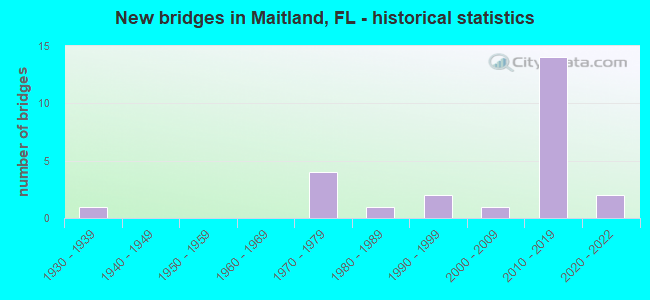
- New bridges - historical statistics
- 11930-1939
- 41970-1979
- 11980-1989
- 21990-1999
- 12000-2009
- 142010-2019
- 22020-2022
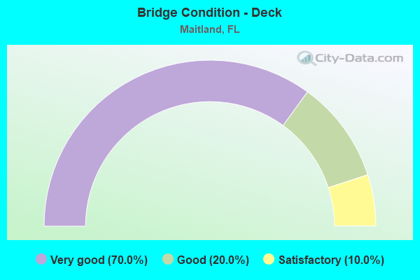
- Bridge Condition - Deck
- 70.0%Very good
- 20.0%Good
- 10.0%Satisfactory
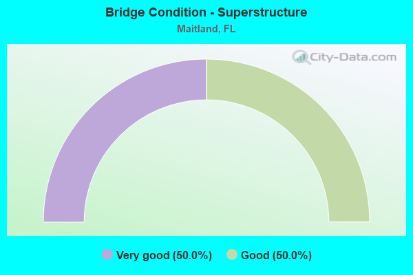
- Bridge Condition - Superstructure
- 50.0%Very good
- 50.0%Good
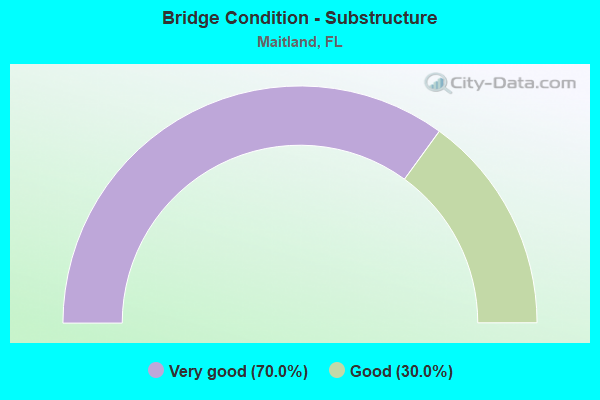
- Bridge Condition - Substructure
- 70.0%Very good
- 30.0%Good
Find on map >> Show street view
Structure Number: 750295, Location: SR-414 -US-17-92&SCLRR (Lat: 28.637203, Lng: -81.359619), Route carried "on" structure: State highway 414, Year Built: 1977, Status: Open, Structure Length: 21.85m (71.69ft), Average Daily Traffic: 30,500 (year 2020), Truck Traffic: 4%, Average Future Daily Traffic: 52,918 (year 2042), Design Load: HS 20, Features Intersected: US-17/92 & SCLRR
Minimum Vertical Clearance: 30+ m (98+ ft), Kilometerpoint: 3.304, Lanes on structure: 4, Lanes under structure: 9, Owner: State Highway Agency, Approaching Roadway Width: 24.1m (79.1ft), Skew: 34 degrees, Material/Design: Prestressed concrete, Design/Construction: Stringer/Multi-beam, Number Of Spans In Main Unit: 10, Length of Maximum Span: 28.7m (94.2ft), Curb-To-Curb Width: 23.8m (78.1ft), Out-to-Out Width: 25.5m (83.7ft)
Condition: Deck: Satisfactory, Superstructure: Good, Substructure: Good, Operating Rating: 64.9 metric tons, Method Used To Determine Operating Rating: Load Factor (LF), Inventory Rating: 39.6 metric tons, Method Used To Determine Inventory Rating: Load Factor (LF), Structural Evaluation: Better than present minimum criteria, Deck Geometry: Superior to present desirable criteria, Underclear: Superior to present desirable criteria, Approach Roadway Alignment: Better than present minimum criteria, Designated Inspection Frequency: Every 24 months, Inspection Date: January 2022, Deck Structure Type: Concrete Cast-file-Place, Wearing Surface/Protective System: Wearing Surface: Epoxy Overlay
Find on map >> Show street view
Structure Number: 750885, Location: 0.1 mile East of I-4 (Lat: 28.631500, Lng: -81.385889), Route carried "on" structure: State highway 414, Year Built: 2017, Status: Open, Structure Length: 2.22m (7.28ft), Average Daily Traffic: 83,200 (year 2020), Truck Traffic: 8%, Average Future Daily Traffic: 92,700 (year 2040), Design Load: HL 93, Features Intersected: Ramp C1
Minimum Vertical Clearance: 30.18m (99.02ft), Kilometerpoint: 0.369, Lanes on structure: 3, Lanes under structure: 2, Base Highway Network: Yes, Owner: State Highway Agency, Approaching Roadway Width: 18.4m (60.4ft), Skew: 7 degrees, Material/Design: Prestressed concrete, Design/Construction: Stringer/Multi-beam, Number Of Spans In Main Unit: 1, Length of Maximum Span: 22.2m (72.8ft), Curb-To-Curb Width: 18.4m (60.4ft), Out-to-Out Width: 19.4m (63.6ft)
Condition: Deck: Very good, Superstructure: Very good, Substructure: Very good, Operating Rating: 43.1 metric tons, Method Used To Determine Operating Rating: Load and Resistance Factor (LRFR), Inventory Rating: 36.9 metric tons, Method Used To Determine Inventory Rating: Load and Resistance Factor (LRFR), Structural Evaluation: Equal to present desirable criteria, Deck Geometry: Superior to present desirable criteria, Underclear: Somewhat better than minimum adequacy, Approach Roadway Alignment: Equal to present desirable criteria, Designated Inspection Frequency: Every 24 months, Inspection Date: October 2020, Deck Structure Type: Concrete Cast-file-Place
Find on map >> Show street view
Structure Number: 750894, Location: 1 mile West of I-4 (Lat: 28.636194, Lng: -81.402778), Route carried "on" structure: State highway 414, Year Built: 2017, Status: Open, Structure Length: 4.75m (15.58ft), Average Daily Traffic: 19,000 (year 2020), Truck Traffic: 18%, Average Future Daily Traffic: 32,965 (year 2040), Design Load: HL 93, Features Intersected: Maitland Summit Blvd
Minimum Vertical Clearance: 30.18m (99.02ft), Kilometerpoint: 63.167, Lanes on structure: 4, Lanes under structure: 8, Base Highway Network: Yes, Owner: State Highway Agency, Approaching Roadway Width: 29.3m (96.1ft), Skew: 30 degrees, Material/Design: Prestressed concrete, Design/Construction: Stringer/Multi-beam, Number Of Spans In Main Unit: 1, Length of Maximum Span: 47.5m (155.8ft), Curb-To-Curb Width: 29.3m (96.1ft), Out-to-Out Width: 30.8m (101.0ft)
Condition: Deck: Very good, Superstructure: Very good, Substructure: Very good, Operating Rating: 36.9 metric tons, Method Used To Determine Operating Rating: Load and Resistance Factor (LRFR), Inventory Rating: 32.7 metric tons, Method Used To Determine Inventory Rating: Load and Resistance Factor (LRFR), Structural Evaluation: Equal to present desirable criteria, Deck Geometry: Superior to present desirable criteria, Underclear: Equal to present minimum criteria, Approach Roadway Alignment: Equal to present desirable criteria, Designated Inspection Frequency: Every 24 months, Inspection Date: November 2020, Deck Structure Type: Concrete Cast-file-Place
Find on map >> Show street view
Structure Number: 750895, Location: WB SR-414 over I-4 (Lat: 28.631667, Lng: -81.387778), Route carried "on" structure: State highway 414, Year Built: 2017, Status: Open, Structure Length: 9.42m (30.91ft), Average Daily Traffic: 19,000 (year 2020), Truck Traffic: 18%, Average Future Daily Traffic: 32,965 (year 2040), Design Load: HL 93, Features Intersected: I-4
Minimum Vertical Clearance: 30.45m (99.90ft), Kilometerpoint: 0.322, Lanes on structure: 5, Lanes under structure: 12, Base Highway Network: Yes, Owner: State Highway Agency, Approaching Roadway Width: 25.6m (84.0ft), Skew: 9 degrees, Material/Design: Prestressed concrete, Design/Construction: Stringer/Multi-beam, Number Of Spans In Main Unit: 2, Length of Maximum Span: 48.6m (159.4ft), Curb-To-Curb Width: 25.6m (84.0ft), Out-to-Out Width: 26.5m (86.9ft)
Condition: Deck: Very good, Superstructure: Very good, Substructure: Very good, Operating Rating: 37.2 metric tons, Method Used To Determine Operating Rating: Load and Resistance Factor (LRFR), Inventory Rating: 33.3 metric tons, Method Used To Determine Inventory Rating: Load and Resistance Factor (LRFR), Structural Evaluation: Equal to present desirable criteria, Deck Geometry: Superior to present desirable criteria, Underclear: High priority of corrective action, Approach Roadway Alignment: Equal to present desirable criteria, Designated Inspection Frequency: Every 24 months, Inspection Date: October 2020, Deck Structure Type: Concrete Cast-file-Place
Find on map >> Show street view
Structure Number: 750904, Location: 0.3 miles West of I-4 (Lat: 28.630806, Lng: -81.392722), Route carried "on" structure: State highway 414, Year Built: 2017, Status: Open, Structure Length: 4.85m (15.91ft), Average Daily Traffic: 83,200 (year 2020), Truck Traffic: 8%, Average Future Daily Traffic: 92,700 (year 2040), Design Load: HL 93, Features Intersected: Lake Destiny Rd
Minimum Vertical Clearance: 6.49m (21.29ft), Kilometerpoint: 64.374, Lanes on structure: 8, Lanes under structure: 5, Base Highway Network: Yes, Owner: State Highway Agency, Approaching Roadway Width: 43.9m (144.0ft), Skew: 37 degrees, Material/Design: Prestressed concrete, Design/Construction: Stringer/Multi-beam, Number Of Spans In Main Unit: 1, Length of Maximum Span: 47.9m (157.2ft), Curb-To-Curb Width: 43.9m (144.0ft), Out-to-Out Width: 45.5m (149.3ft)
Condition: Deck: Very good, Superstructure: Very good, Substructure: Very good, Operating Rating: 37.9 metric tons, Method Used To Determine Operating Rating: Load and Resistance Factor (LRFR), Inventory Rating: 33.9 metric tons, Method Used To Determine Inventory Rating: Load and Resistance Factor (LRFR), Structural Evaluation: Equal to present desirable criteria, Deck Geometry: Superior to present desirable criteria, Underclear: Equal to present minimum criteria, Approach Roadway Alignment: Equal to present desirable criteria, Designated Inspection Frequency: Every 24 months, Inspection Date: November 2020, Deck Structure Type: Concrete Cast-file-Place
Find on map >> Show street view
Structure Number: 750917, Location: 2mi West of SR 434 (Lat: 28.631028, Lng: -81.387417), Route carried "on" structure: State highway 414, Year Built: 2018, Status: Open, Structure Length: 9.37m (30.74ft), Average Daily Traffic: 19,500 (year 2020), Truck Traffic: 10%, Average Future Daily Traffic: 33,832 (year 2040), Design Load: HL 93, Features Intersected: I-4
Minimum Vertical Clearance: 30+ m (98+ ft), Kilometerpoint: 0.462, Lanes on structure: 5, Lanes under structure: 12, Base Highway Network: Yes, Owner: State Highway Agency, Approaching Roadway Width: 25.6m (84.0ft), Skew: 1 degrees, Material/Design: Prestressed concrete, Design/Construction: Stringer/Multi-beam, Number Of Spans In Main Unit: 2, Length of Maximum Span: 48.2m (158.1ft), Curb-To-Curb Width: 25.6m (84.0ft), Out-to-Out Width: 26.5m (86.9ft)
Condition: Deck: Very good, Superstructure: Good, Substructure: Very good, Operating Rating: 41.8 metric tons, Method Used To Determine Operating Rating: Load and Resistance Factor (LRFR), Inventory Rating: 37.6 metric tons, Method Used To Determine Inventory Rating: Load and Resistance Factor (LRFR), Structural Evaluation: Better than present minimum criteria, Deck Geometry: Superior to present desirable criteria, Underclear: Better than present minimum criteria, Approach Roadway Alignment: Equal to present desirable criteria, Designated Inspection Frequency: Every 24 months, Inspection Date: August 2020, Deck Structure Type: Concrete Cast-file-Place
Find on map >> Show street view
Structure Number: 750918, Location: 0.2 miles West of I-4 (Lat: 28.630917, Lng: -81.389667), Route carried "on" structure: State highway 414, Year Built: 2018, Status: Open, Structure Length: 2.47m (8.10ft), Average Daily Traffic: 83,200 (year 2020), Truck Traffic: 8%, Average Future Daily Traffic: 92,700 (year 2040), Design Load: HL 93, Features Intersected: I-4 Ramp A1
Minimum Vertical Clearance: 30+ m (98+ ft), Kilometerpoint: 64.696, Lanes on structure: 4, Lanes under structure: 1, Base Highway Network: Yes, Owner: State Highway Agency, Approaching Roadway Width: 21.9m (71.9ft), Skew: 9 degrees, Material/Design: Concrete, Design/Construction: Stringer/Multi-beam, Number Of Spans In Main Unit: 1, Length of Maximum Span: 24.7m (81.0ft), Curb-To-Curb Width: 21.9m (71.9ft), Out-to-Out Width: 22.9m (75.1ft)
Condition: Deck: Very good, Superstructure: Very good, Substructure: Very good, Operating Rating: 49.6 metric tons, Method Used To Determine Operating Rating: Load and Resistance Factor (LRFR), Inventory Rating: 34.9 metric tons, Method Used To Determine Inventory Rating: Load and Resistance Factor (LRFR), Structural Evaluation: Equal to present desirable criteria, Deck Geometry: Superior to present desirable criteria, Underclear: Better than present minimum criteria, Approach Roadway Alignment: Equal to present desirable criteria, Designated Inspection Frequency: Every 24 months, Inspection Date: October 2020, Deck Structure Type: Concrete Cast-file-Place
Find on map >> Show street view
Structure Number: 750939, Location: 1.7MI N/O Lee Rd (Lat: 28.630722, Lng: -81.385139), Route carried "on" structure: Ramp Interstate 4, Year Built: 2020, Status: Open, Structure Length: 3.38m (11.09ft), Average Daily Traffic: 5,000 (year 2020), Truck Traffic: 5%, Average Future Daily Traffic: 6,000 (year 2040), Design Load: HL 93, Features Intersected: Wymore Road
Minimum Vertical Clearance: 30.45m (99.90ft), Kilometerpoint: 0.161, Lanes on structure: 1, Lanes under structure: 2, Owner: State Highway Agency, Approaching Roadway Width: 8.2m (26.9ft), Material/Design: Prestressed concrete, Design/Construction: Stringer/Multi-beam, Number Of Spans In Main Unit: 1, Length of Maximum Span: 33.8m (110.9ft), Curb-To-Curb Width: 8.2m (26.9ft), Out-to-Out Width: 9.1m (29.9ft)
Condition: Deck: Very good, Superstructure: Good, Substructure: Very good, Operating Rating: 38.8 metric tons, Method Used To Determine Operating Rating: Load and Resistance Factor (LRFR), Inventory Rating: 33.9 metric tons, Method Used To Determine Inventory Rating: Load and Resistance Factor (LRFR), Structural Evaluation: Better than present minimum criteria, Deck Geometry: Superior to present desirable criteria, Underclear: Superior to present desirable criteria, Approach Roadway Alignment: Equal to present minimum criteria, Designated Inspection Frequency: Every 24 months, Inspection Date: May 2020, Deck Structure Type: Concrete Cast-file-Place
Find on map >> Show street view
Structure Number: 754073, Location: 1.5 Miles West of SR-436 (Lat: 28.624689, Lng: -81.342539), Route carried "on" structure: County highway , Year Built: 1983, Status: Open, Structure Length: 1.95m (6.40ft), Average Daily Traffic: 33,000 (year 2021), Truck Traffic: 5%, Average Future Daily Traffic: 57,255 (year 2042), Design Load: HS 20, Features Intersected: Howell Branch Creek, Facility Carried by Structure: Howell Branch Road
Minimum Vertical Clearance: 30+ m (98+ ft), Kilometerpoint: 2.219, Lanes on structure: 4, Owner: County Highway Agency, Approaching Roadway Width: 22.7m (74.5ft), Skew: 20 degrees, Material/Design: Concrete continuous, Design/Construction: Tee Beam, Number Of Spans In Main Unit: 2, Length of Maximum Span: 9.8m (32.2ft), Curb or Sidewalk Widths: Left: 1.5m (4.9ft), Right: 1.5m (4.9ft), Curb-To-Curb Width: 22.7m (74.5ft), Out-to-Out Width: 26.8m (87.9ft)
Condition: Deck: Good, Superstructure: Good, Substructure: Good, Channel: Good, Operating Rating: 86.1 metric tons, Method Used To Determine Operating Rating: Load Factor (LF), Inventory Rating: 56.5 metric tons, Method Used To Determine Inventory Rating: Load Factor (LF), Structural Evaluation: Better than present minimum criteria, Deck Geometry: Superior to present desirable criteria, Waterway Adequacy: Equal to present desirable criteria, Approach Roadway Alignment: Better than present minimum criteria, Designated Inspection Frequency: Every 24 months, Inspection Date: October 2021, Deck Structure Type: Concrete Cast-file-Place, Wearing Surface/Protective System: Wearing Surface: Bituminous
Find on map >> Show street view
Structure Number: 754075, Location: 0.4 mi E of US-17-92 (Lat: 28.627372, Lng: -81.357547), Route carried "on" structure: County highway , Year Built: 1971, Status: Open, Structure Length: 0.76m (2.49ft), Average Daily Traffic: 33,000 (year 2021), Truck Traffic: 5%, Average Future Daily Traffic: 57,255 (year 2042), Design Load: H 20, Features Intersected: Nina Canal, Facility Carried by Structure: Horatio Ave
Minimum Vertical Clearance: 30+ m (98+ ft), Kilometerpoint: 0.576, Lanes on structure: 4, Owner: County Highway Agency, Approaching Roadway Width: 21.6m (70.9ft), Skew: 21 degrees, Material/Design: Concrete, Design/Construction: Culvert, Number Of Spans In Main Unit: 2, Length of Maximum Span: 3.7m (12.1ft)
Condition: Channel: Good, Culverts: Good, Structural Evaluation: Better than present minimum criteria, Waterway Adequacy: Equal to present desirable criteria, Approach Roadway Alignment: Equal to present desirable criteria, Designated Inspection Frequency: Every 24 months, Underwater Inspection Frequency: Every 24 months, Inspection Date: October 2021, Underwater Inspection Date: October 2021
Find on map >> Show street view
Structure Number: 770074, Location: SR-414 over Lake Bosse (Lat: 28.640192, Lng: -81.430714), Route carried "on" structure: State highway 414, Year Built: 2000, Status: Open, Structure Length: 21.40m (70.21ft), Average Daily Traffic: 47,500 (year 2020), Truck Traffic: 4%, Average Future Daily Traffic: 82,412 (year 2042), Design Load: HS 20, Features Intersected: Lake Bosse
Minimum Vertical Clearance: 30+ m (98+ ft), Kilometerpoint: 60.189, Lanes on structure: 4, Owner: State Highway Agency, Approaching Roadway Width: 28.5m (93.5ft), Skew: 20 degrees, Material/Design: Steel, Design/Construction: Stringer/Multi-beam, Number Of Spans In Main Unit: 1, Number Of Approach Spans: 5, Length of Maximum Span: 64.0m (210.0ft), Curb or Sidewalk Widths: Left: 1.5m (4.9ft), Right: 1.5m (4.9ft), Curb-To-Curb Width: 28.5m (93.5ft), Out-to-Out Width: 39.3m (128.9ft)
Condition: Deck: Good, Superstructure: Good, Substructure: Good, Channel: Good, Operating Rating: 73.4 metric tons, Method Used To Determine Operating Rating: Load Factor (LF), Inventory Rating: 44.2 metric tons, Method Used To Determine Inventory Rating: Load Factor (LF), Structural Evaluation: Better than present minimum criteria, Deck Geometry: Superior to present desirable criteria, Waterway Adequacy: Superior to present desirable criteria, Approach Roadway Alignment: Equal to present desirable criteria, Designated Inspection Frequency: Every 24 months, Inspection Date: April 2021, Deck Structure Type: Concrete Cast-file-Place, Wearing Surface/Protective System: Wearing Surface: Monolithic Concrete
Find on map >> Show street view
Structure Number: 750255, Location: Maitland (Lat: 28.612306, Lng: -81.365361), Route carried "under" structure: US 600, Year Built: 1938, Structure Length: 0. m, Average Daily Traffic: 40,000 (year 2020), Truck Traffic: 4%, Features Intersected: US-17-92, Facility Carried by Structure: CFRC RR (Sunrail)
Minimum Vertical Clearance: 4.11m (13.48ft), Kilometerpoint: 10.749, Lanes under structure: 5, Material/Design: Steel, Design/Construction: Girder and Floorbeam System, Length of Maximum Span: 46.5m (152.6ft)
Find on map >> Show street view
Structure Number: 750295, Location: SR-414 -US-17-92&SCLRR (Lat: 28.637203, Lng: -81.359619), Route carried "under" structure: US 600, Year Built: 1977, Structure Length: 0. m, Average Daily Traffic: 32,000 (year 2020), Truck Traffic: 4%, Features Intersected: US-17/92 & SCLRR, Facility Carried by Structure: SR-414
Minimum Vertical Clearance: 5.12m (16.80ft), Kilometerpoint: 13.699, Lanes on structure: 4, Lanes under structure: 7, Material/Design: Prestressed concrete, Design/Construction: Stringer/Multi-beam, Length of Maximum Span: 28.7m (94.2ft)
Find on map >> Show street view
Structure Number: 750295, Location: SR-414 -US-17-92&SCLRR (Lat: 28.637203, Lng: -81.359619), Route carried "under" structure: City street , Year Built: 1977, Structure Length: 0. m, Average Daily Traffic: 32,000 (year 2020), Truck Traffic: 4%, Features Intersected: US-17/92 & SCLRR, Facility Carried by Structure: SR-414
Minimum Vertical Clearance: 6.34m (20.80ft), Kilometerpoint: 13.699, Lanes on structure: 4, Lanes under structure: 2, Material/Design: Prestressed concrete, Design/Construction: Stringer/Multi-beam, Length of Maximum Span: 28.7m (94.2ft)
Find on map >> Show street view
Structure Number: 750885, Location: 0.1 mile East of I-4 (Lat: 28.631500, Lng: -81.385889), Route carried "under" structure: Ramp Interstate , Year Built: 2017, Structure Length: 0. m, Average Daily Traffic: 83,200 (year 2020), Truck Traffic: 8%, Features Intersected: Ramp C1, Facility Carried by Structure: SR 414
Minimum Vertical Clearance: 5.36m (17.59ft), Kilometerpoint: 0.000, Lanes on structure: 3, Lanes under structure: 2, Material/Design: Prestressed concrete, Design/Construction: Stringer/Multi-beam, Length of Maximum Span: 22.2m (72.8ft)
Find on map >> Show street view
Structure Number: 750894, Location: 1 mile West of I-4 (Lat: 28.636194, Lng: -81.402778), Route carried "under" structure: City street , Year Built: 2017, Structure Length: 0. m, Average Daily Traffic: 9,000 (year 2020), Truck Traffic: 3%, Features Intersected: Maitland Summit Blvd, Facility Carried by Structure: SR-414
Minimum Vertical Clearance: 5.06m (16.60ft), Kilometerpoint: 0.000, Lanes on structure: 4, Lanes under structure: 8, Material/Design: Prestressed concrete, Design/Construction: Stringer/Multi-beam, Length of Maximum Span: 47.5m (155.8ft)
Find on map >> Show street view
Structure Number: 750895, Location: WB SR-414 over I-4 (Lat: 28.631667, Lng: -81.387778), Route carried "under" structure: Interstate 4, Year Built: 2017, Structure Length: 0. m, Average Daily Traffic: 80,000 (year 2020), Truck Traffic: 4%, Features Intersected: I-4
Minimum Vertical Clearance: 5.27m (17.29ft), Kilometerpoint: 38.624, Lanes on structure: 5, Lanes under structure: 12, Material/Design: Prestressed concrete, Design/Construction: Stringer/Multi-beam, Length of Maximum Span: 48.6m (159.4ft)
Find on map >> Show street view
Structure Number: 750904, Location: 0.3 miles West of I-4 (Lat: 28.630806, Lng: -81.392722), Route carried "under" structure: City street , Year Built: 2017, Structure Length: 0. m, Average Daily Traffic: 83,200 (year 2020), Truck Traffic: 8%, Features Intersected: Lake Destiny Rd, Facility Carried by Structure: SR-414
Minimum Vertical Clearance: 6.49m (21.29ft), Kilometerpoint: 0.000, Lanes on structure: 8, Lanes under structure: 5, Material/Design: Prestressed concrete, Design/Construction: Stringer/Multi-beam, Length of Maximum Span: 47.9m (157.2ft)
Find on map >> Show street view
Structure Number: 750917, Location: 2mi West of SR 434 (Lat: 28.631028, Lng: -81.387417), Route carried "under" structure: Interstate 4, Year Built: 2018, Structure Length: 0. m, Average Daily Traffic: 79,000 (year 2020), Truck Traffic: 10%, Features Intersected: I-4
Minimum Vertical Clearance: 5.52m (18.11ft), Kilometerpoint: 38.737, Lanes on structure: 5, Lanes under structure: 10, Material/Design: Prestressed concrete, Design/Construction: Stringer/Multi-beam, Length of Maximum Span: 48.2m (158.1ft)
Find on map >> Show street view
Structure Number: 750917, Location: 2mi West of SR 434 (Lat: 28.631028, Lng: -81.387417), Route carried "under" structure: Ramp Interstate 4, Year Built: 2018, Structure Length: 0. m, Average Daily Traffic: 14,500 (year 2020), Truck Traffic: 10%, Features Intersected: I-4
Minimum Vertical Clearance: 5.46m (17.91ft), Kilometerpoint: 0.187, Lanes on structure: 5, Lanes under structure: 1, Material/Design: Prestressed concrete, Design/Construction: Stringer/Multi-beam, Length of Maximum Span: 48.2m (158.1ft)
Find on map >> Show street view
Structure Number: 750917, Location: 2mi West of SR 434 (Lat: 28.631028, Lng: -81.387417), Route carried "under" structure: Ramp State highway 414, Year Built: 2018, Structure Length: 0. m, Average Daily Traffic: 19,500 (year 2020), Truck Traffic: 10%, Features Intersected: I-4
Minimum Vertical Clearance: 6.74m (22.11ft), Kilometerpoint: 0.462, Lanes on structure: 5, Lanes under structure: 1, Material/Design: Prestressed concrete, Design/Construction: Stringer/Multi-beam, Length of Maximum Span: 48.2m (158.1ft)
Find on map >> Show street view
Structure Number: 750918, Location: 0.2 miles West of I-4 (Lat: 28.630917, Lng: -81.389667), Route carried "under" structure: Ramp Interstate 4, Year Built: 2018, Structure Length: 0. m, Average Daily Traffic: 28,000 (year 2020), Features Intersected: I-4 Ramp A1
Minimum Vertical Clearance: 5.15m (16.90ft), Kilometerpoint: 0.000, Lanes on structure: 4, Lanes under structure: 1, Material/Design: Concrete, Design/Construction: Stringer/Multi-beam, Length of Maximum Span: 24.7m (81.0ft)
Find on map >> Show street view
Structure Number: 750939, Location: 1.7MI N/O Lee Rd (Lat: 28.630722, Lng: -81.385139), Route carried "under" structure: City street , Year Built: 2020, Structure Length: 0. m, Average Daily Traffic: 1,440 (year 2020), Truck Traffic: 5%, Features Intersected: Wymore Road, Facility Carried by Structure: I4 OffRmp/Wymore
Minimum Vertical Clearance: 5.46m (17.91ft), Kilometerpoint: 0.000, Lanes on structure: 1, Lanes under structure: 2, Material/Design: Prestressed concrete, Design/Construction: Stringer/Multi-beam, Length of Maximum Span: 33.8m (110.9ft)
Find on map >> Show street view
Structure Number: 759006, Location: Pedestrian OP over 17-92 (Lat: 28.637028, Lng: -81.358944), Route carried "under" structure: US 500, Year Built: 1998, Structure Length: 0. m, Average Daily Traffic: 32,000 (year 2020), Truck Traffic: 4%, Features Intersected: US-17-92, Facility Carried by Structure: Pedestrian O.P.
Minimum Vertical Clearance: 5.49m (18.01ft), Kilometerpoint: 13.687, Lanes under structure: 7, Material/Design: Steel continuous, Design/Construction: Truss - Thru, Length of Maximum Span: 60.3m (197.8ft)
Find on map >> Show street view
Structure Number: 759006, Location: Pedestrian OP over 17-92 (Lat: 28.637028, Lng: -81.358944), Route carried "under" structure: City street , Year Built: 1998, Structure Length: 0. m, Average Daily Traffic: 100 (year 2007), Truck Traffic: 1%, Features Intersected: US-17-92, Facility Carried by Structure: Pedestrian O.P.
Minimum Vertical Clearance: 7.41m (24.31ft), Kilometerpoint: 0.000, Lanes under structure: 2, Material/Design: Steel continuous, Design/Construction: Truss - Thru, Length of Maximum Span: 60.3m (197.8ft)