Bridge Statistics for Lynnwood, Washington (WA)
Condition, Traffic, Stress, Structural Evaluation, Project Costs
- National Bridge Inventory (NBI) Statistics
- 23Number of bridges
- 390ft / 119mTotal length
- $88,037,000Total costs
- 1,098,976Total average daily traffic
- 55,432Total average daily truck traffic
- National Bridge Inventory (NBI) Registered Bridges for Lynnwood
- No street view available for this location
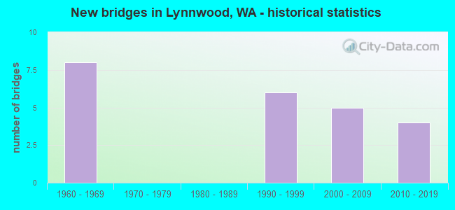
- New bridges - historical statistics
- 81960-1969
- 61990-1999
- 52000-2009
- 42010-2019

- Reconstructed bridges - Historical Statistics
- 11980-1989
- 31990-1999


- Bridge Condition - Deck
- 54.5%Good
- 27.3%Satisfactory
- 18.2%Fair

- Bridge Condition - Superstructure
- 72.7%Good
- 18.2%Satisfactory
- 9.1%Fair

- Bridge Condition - Culverts
- 50.0%Very good
- 50.0%Satisfactory
Find on map >> Show street view
Structure Number: KMA, Location: 0.6 N JCT SR 524 (Lat: 47.827028, Lng: -122.268972), Route carried "on" structure: City street , Year Built: 1996, Status: Open, Structure Length: 15.51m (50.89ft), Average Daily Traffic: 2,635 (year 2002), Truck Traffic: 5%, Average Future Daily Traffic: 4,785 (year 2036), Design Load: HS 25 or greater, Features Intersected: I-5, Facility Carried by Structure: ALDERWOOD MALL PKW
Minimum Vertical Clearance: 30+ m (98+ ft), Kilometerpoint: 0.032, Lanes on structure: 6, Lanes under structure: 10, Owner: State Highway Agency, Approaching Roadway Width: 20.7m (67.9ft), Skew: 4 degrees, Material/Design: Prestressed concrete continuous, Design/Construction: Stringer/Multi-beam, Number Of Spans In Main Unit: 4, Length of Maximum Span: 46.0m (150.9ft), Curb or Sidewalk Widths: Left: 2.4m (7.9ft), Right: 2.4m (7.9ft), Curb-To-Curb Width: 20.7m (67.9ft), Out-to-Out Width: 25.9m (85.0ft)
Condition: Deck: Good, Superstructure: Good, Substructure: Good, Operating Rating: 89.8 metric tons, Method Used To Determine Operating Rating: Load Factor (LF), Inventory Rating: 74.4 metric tons, Method Used To Determine Inventory Rating: Load Factor (LF), Structural Evaluation: Better than present minimum criteria, Deck Geometry: High priority of replacement, Underclear: Meets minimum limits, Approach Roadway Alignment: Equal to present desirable criteria, Length Of Structure Improvement: 15.51m (50.89ft), Designated Inspection Frequency: Every 24 months, Inspection Date: July 2021, Bridge Improvement Cost: $7,126,000, Roadway Improvement Cost: $1,425,000, Total Project Cost: $14,252,000 ( Estimate for 2014), Deck Structure Type: Concrete Cast-file-Place, Wearing Surface/Protective System: Wearing Surface: Monolithic Concrete, Deck Protection: Epoxy Coated Reinforcing
Find on map >> Show street view
Structure Number: 7118A, Location: 3.0 N JCT SR 104 (Lat: 47.813500, Lng: -122.292694), Route carried "on" structure: Interstate 5, Year Built: 1963, Year Reconstructed: 1995, Status: Open, Structure Length: 7.47m (24.51ft), Average Daily Traffic: 86,261 (year 2019), Truck Traffic: 6%, Average Future Daily Traffic: 124,905 (year 2039), Design Load: HS 20, Features Intersected: SR 524 SPUR/44TH AVE W
Minimum Vertical Clearance: 30+ m (98+ ft), Kilometerpoint: 290.825, Lanes on structure: 4, Lanes under structure: 4, Base Highway Network: Yes, Owner: State Highway Agency, Approaching Roadway Width: 20.7m (67.9ft), Skew: 3 degrees, Material/Design: Prestressed concrete, Design/Construction: Stringer/Multi-beam, Number Of Spans In Main Unit: 3, Length of Maximum Span: 28.0m (91.9ft), Curb-To-Curb Width: 20.7m (67.9ft), Out-to-Out Width: 21.6m (70.9ft)
Condition: Deck: Fair, Superstructure: Satisfactory, Substructure: Good, Operating Rating: 62.6 metric tons, Method Used To Determine Operating Rating: Load Factor (LF), Inventory Rating: 37.2 metric tons, Method Used To Determine Inventory Rating: Load Factor (LF), Structural Evaluation: Equal to present minimum criteria, Deck Geometry: Equal to present minimum criteria, Underclear: High priority of corrective action, Approach Roadway Alignment: Equal to present desirable criteria, Length Of Structure Improvement: 7.47m (24.51ft), Designated Inspection Frequency: Every 24 months, Inspection Date: Febuary 2020, Bridge Improvement Cost: $3,430,000, Roadway Improvement Cost: $686,000, Total Project Cost: $6,860,000 ( Estimate for 2014), Deck Structure Type: Concrete Cast-file-Place, Wearing Surface/Protective System: Wearing Surface: Integral Concrete
Find on map >> Show street view
Structure Number: 7118B, Location: 3.0 N JCT SR 104 (Lat: 47.813972, Lng: -122.292694), Route carried "on" structure: Interstate 5, Year Built: 1963, Year Reconstructed: 1995, Status: Open, Structure Length: 7.92m (25.98ft), Average Daily Traffic: 86,261 (year 2019), Truck Traffic: 6%, Average Future Daily Traffic: 124,905 (year 2039), Design Load: HS 20, Features Intersected: SR 524 SPUR/44TH AVE W
Minimum Vertical Clearance: 30+ m (98+ ft), Kilometerpoint: 290.825, Lanes on structure: 4, Lanes under structure: 5, Base Highway Network: Yes, Owner: State Highway Agency, Approaching Roadway Width: 20.7m (67.9ft), Skew: 3 degrees, Material/Design: Prestressed concrete, Design/Construction: Stringer/Multi-beam, Number Of Spans In Main Unit: 3, Length of Maximum Span: 28.0m (91.9ft), Curb-To-Curb Width: 20.7m (67.9ft), Out-to-Out Width: 21.6m (70.9ft)
Condition: Deck: Satisfactory, Superstructure: Good, Substructure: Good, Operating Rating: 58.0 metric tons, Method Used To Determine Operating Rating: Load Factor (LF), Inventory Rating: 33.6 metric tons, Method Used To Determine Inventory Rating: Load Factor (LF), Structural Evaluation: Better than present minimum criteria, Deck Geometry: Equal to present minimum criteria, Underclear: High priority of corrective action, Approach Roadway Alignment: Equal to present desirable criteria, Length Of Structure Improvement: 7.92m (25.98ft), Designated Inspection Frequency: Every 24 months, Inspection Date: Febuary 2020, Bridge Improvement Cost: $3,640,000, Roadway Improvement Cost: $728,000, Total Project Cost: $7,280,000 ( Estimate for 2014), Deck Structure Type: Concrete Cast-file-Place, Wearing Surface/Protective System: Wearing Surface: Integral Concrete
Find on map >> Show street view
Structure Number: 7134B, Location: 1.6 E JCT SR 99 (Lat: 47.820917, Lng: -122.280250), Route carried "on" structure: State highway 524, Year Built: 1964, Status: Open, Structure Length: 14.97m (49.11ft), Average Daily Traffic: 40,965 (year 2019), Truck Traffic: 2%, Average Future Daily Traffic: 59,317 (year 2039), Design Load: HS 20, Features Intersected: I-5
Minimum Vertical Clearance: 30+ m (98+ ft), Kilometerpoint: 8.369, Lanes on structure: 5, Lanes under structure: 10, Base Highway Network: Yes, Owner: State Highway Agency, Approaching Roadway Width: 18.9m (62.0ft), Skew: 5 degrees, Material/Design: Concrete continuous, Design/Construction: Box Beam or Girders - Multiple, Number Of Spans In Main Unit: 5, Length of Maximum Span: 34.4m (112.9ft), Curb or Sidewalk Widths: Left: 2.9m (9.5ft), Right: 0.0m, Curb-To-Curb Width: 18.6m (61.0ft), Out-to-Out Width: 22.8m (74.8ft)
Condition: Deck: Satisfactory, Superstructure: Satisfactory, Substructure: Good, Operating Rating: 33.7 metric tons, Method Used To Determine Operating Rating: Load and Resistance Factor Rating (LRFR) rating reported by rating factor(RF) method using HL-93 loadings, Inventory Rating: 26.2 metric tons, Method Used To Determine Inventory Rating: Load and Resistance Factor Rating (LRFR) rating reported by rating factor(RF) method using HL-93 loadings, Structural Evaluation: Equal to present minimum criteria, Deck Geometry: High priority of corrective action, Underclear: High priority of corrective action, Approach Roadway Alignment: Equal to present desirable criteria, Length Of Structure Improvement: 14.97m (49.11ft), Designated Inspection Frequency: Every 48 months, Inspection Date: October 2018, Bridge Improvement Cost: $6,285,000, Roadway Improvement Cost: $1,257,000, Total Project Cost: $12,570,000 ( Estimate for 2014), Deck Structure Type: Concrete Cast-file-Place, Wearing Surface/Protective System: Wearing Surface: Latex Concrete
Find on map >> Show street view
Structure Number: 7227B, Location: 2.3 N JCT SR 104 (Lat: 47.807778, Lng: -122.303472), Route carried "on" structure: Interstate 5, Year Built: 1963, Year Reconstructed: 1995, Status: Open, Structure Length: 5.76m (18.90ft), Average Daily Traffic: 104,565 (year 2019), Truck Traffic: 5%, Average Future Daily Traffic: 151,410 (year 2039), Design Load: HS 20, Features Intersected: 52ND AVE W
Minimum Vertical Clearance: 30+ m (98+ ft), Kilometerpoint: 289.795, Lanes on structure: 5, Lanes under structure: 4, Base Highway Network: Yes, Owner: State Highway Agency, Approaching Roadway Width: 20.7m (67.9ft), Skew: 3 degrees, Material/Design: Prestressed concrete, Design/Construction: Stringer/Multi-beam, Number Of Spans In Main Unit: 3, Length of Maximum Span: 23.2m (76.1ft), Curb-To-Curb Width: 20.9m (68.6ft), Out-to-Out Width: 21.4m (70.2ft)
Condition: Deck: Good, Superstructure: Good, Substructure: Good, Operating Rating: 60.8 metric tons, Method Used To Determine Operating Rating: Load Factor (LF), Inventory Rating: 36.3 metric tons, Method Used To Determine Inventory Rating: Load Factor (LF), Structural Evaluation: Better than present minimum criteria, Deck Geometry: Meets minimum limits, Underclear: Meets minimum limits, Approach Roadway Alignment: Equal to present desirable criteria, Length Of Structure Improvement: 5.76m (18.90ft), Designated Inspection Frequency: Every 24 months, Inspection Date: Febuary 2020, Bridge Improvement Cost: $2,646,000, Roadway Improvement Cost: $529,000, Total Project Cost: $5,292,000 ( Estimate for 2014), Deck Structure Type: Concrete Cast-file-Place, Wearing Surface/Protective System: Wearing Surface: Latex Concrete
Find on map >> Show street view
Structure Number: 7227C, Location: 2.3 N JCT SR 104 (Lat: 47.808194, Lng: -122.303472), Route carried "on" structure: Interstate 5, Year Built: 1963, Year Reconstructed: 1993, Status: Open, Structure Length: 5.24m (17.19ft), Average Daily Traffic: 104,565 (year 2019), Truck Traffic: 5%, Average Future Daily Traffic: 151,410 (year 2039), Design Load: HS 20, Features Intersected: 52ND AVE W
Minimum Vertical Clearance: 30+ m (98+ ft), Kilometerpoint: 289.811, Lanes on structure: 4, Lanes under structure: 3, Base Highway Network: Yes, Owner: State Highway Agency, Approaching Roadway Width: 24.4m (80.1ft), Skew: 3 degrees, Material/Design: Prestressed concrete, Design/Construction: Stringer/Multi-beam, Number Of Spans In Main Unit: 3, Length of Maximum Span: 23.2m (76.1ft), Curb-To-Curb Width: 20.8m (68.2ft), Out-to-Out Width: 21.8m (71.5ft)
Condition: Deck: Satisfactory, Superstructure: Fair, Substructure: Good, Operating Rating: 59.9 metric tons, Method Used To Determine Operating Rating: Load Factor (LF), Inventory Rating: 35.4 metric tons, Method Used To Determine Inventory Rating: Load Factor (LF), Structural Evaluation: Somewhat better than minimum adequacy, Deck Geometry: Equal to present minimum criteria, Underclear: Meets minimum limits, Approach Roadway Alignment: Equal to present desirable criteria, Length Of Structure Improvement: 5.24m (17.19ft), Designated Inspection Frequency: Every 24 months, Inspection Date: Febuary 2020, Bridge Improvement Cost: $2,821,000, Roadway Improvement Cost: $564,000, Total Project Cost: $5,642,000 ( Estimate for 2014), Deck Structure Type: Concrete Cast-file-Place, Wearing Surface/Protective System: Wearing Surface: Integral Concrete
Find on map >> Show street view
Structure Number: 16469A, Location: 3.0 N JCT SR 104 (Lat: 47.814528, Lng: -122.295083), Route carried "on" structure: Ramp Interstate 5, Year Built: 2004, Status: Open, Structure Length: 18.38m (60.30ft), Average Daily Traffic: 5,180 (year 2019), Truck Traffic: 17%, Average Future Daily Traffic: 7,500 (year 2039), Design Load: HS 25 or greater, Features Intersected: SB I-5, Facility Carried by Structure: RAMP
Minimum Vertical Clearance: 30+ m (98+ ft), Kilometerpoint: 0.225, Lanes on structure: 2, Lanes under structure: 7, Owner: State Highway Agency, Approaching Roadway Width: 12.2m (40.0ft), Material/Design: Steel continuous, Design/Construction: Stringer/Multi-beam, Number Of Spans In Main Unit: 5, Length of Maximum Span: 46.0m (150.9ft), Curb-To-Curb Width: 12.3m (40.4ft), Out-to-Out Width: 13.2m (43.3ft)
Condition: Deck: Good, Superstructure: Good, Substructure: Good, Operating Rating: 58.0 metric tons, Method Used To Determine Operating Rating: Load Factor (LF), Inventory Rating: 35.4 metric tons, Method Used To Determine Inventory Rating: Load Factor (LF), Structural Evaluation: Better than present minimum criteria, Deck Geometry: Superior to present desirable criteria, Underclear: High priority of corrective action, Approach Roadway Alignment: Equal to present desirable criteria, Length Of Structure Improvement: 18.38m (60.30ft), Designated Inspection Frequency: Every 24 months, Inspection Date: June 2021, Bridge Improvement Cost: $5,065,000, Roadway Improvement Cost: $1,013,000, Total Project Cost: $10,130,000 ( Estimate for 2014), Deck Structure Type: Concrete Cast-file-Place, Wearing Surface/Protective System: Wearing Surface: Monolithic Concrete, Deck Protection: Epoxy Coated Reinforcing
Find on map >> Show street view
Structure Number: 16469B, Location: 3.0 N JCT SR 104 (Lat: 47.813717, Lng: -122.292758), Route carried "on" structure: Interstate 5, Year Built: 2004, Status: Open, Structure Length: 8.20m (26.90ft), Average Daily Traffic: 1,053 (year 2019), Average Future Daily Traffic: 1,524 (year 2039), Design Load: HL 93, Features Intersected: SR 524 SPUR/44TH AVE W
Minimum Vertical Clearance: 30+ m (98+ ft), Kilometerpoint: 0.129, Lanes on structure: 2, Lanes under structure: 4, Base Highway Network: Yes, Owner: State Highway Agency, Approaching Roadway Width: 14.0m (45.9ft), Skew: 33 degrees, Material/Design: Prestressed concrete continuous, Design/Construction: Stringer/Multi-beam, Number Of Spans In Main Unit: 3, Length of Maximum Span: 34.4m (112.9ft), Curb-To-Curb Width: 13.6m (44.6ft), Out-to-Out Width: 14.6m (47.9ft)
Condition: Deck: Good, Superstructure: Good, Substructure: Good, Operating Rating: 78.0 metric tons, Method Used To Determine Operating Rating: Load Factor (LF), Inventory Rating: 46.3 metric tons, Method Used To Determine Inventory Rating: Load Factor (LF), Structural Evaluation: Better than present minimum criteria, Deck Geometry: Superior to present desirable criteria, Underclear: Meets minimum limits, Approach Roadway Alignment: Equal to present desirable criteria, Length Of Structure Improvement: 8.20m (26.90ft), Designated Inspection Frequency: Every 24 months, Inspection Date: July 2021, Bridge Improvement Cost: $2,582,000, Roadway Improvement Cost: $516,000, Total Project Cost: $5,165,000 ( Estimate for 2014), Deck Structure Type: Concrete Cast-file-Place, Wearing Surface/Protective System: Wearing Surface: Monolithic Concrete, Deck Protection: Epoxy Coated Reinforcing
Find on map >> Show street view
Structure Number: 17945B, Location: 0.4 N JCT SR 524 (Lat: 47.824972, Lng: -122.273222), Route carried "on" structure: Ramp Interstate 5, Year Built: 2012, Status: Open, Structure Length: 8.23m (27.00ft), Average Daily Traffic: 22,783 (year 2019), Truck Traffic: 3%, Average Future Daily Traffic: 32,989 (year 2039), Design Load: HS 20, Features Intersected: DETENTION VAULT
Minimum Vertical Clearance: 30+ m (98+ ft), Kilometerpoint: 1.127, Lanes on structure: 2, Owner: State Highway Agency, Approaching Roadway Width: 12.8m (42.0ft), Material/Design: Concrete, Design/Construction: Culvert, Number Of Spans In Main Unit: 1, Length of Maximum Span: 82.3m (270.0ft), Curb-To-Curb Width: 12.9m (42.3ft), Out-to-Out Width: 4.7m (15.4ft)
Condition: Culverts: Satisfactory, Operating Rating: 54.4 metric tons, Method Used To Determine Operating Rating: Field evaluation and documented engineering judgment, Inventory Rating: 32.7 metric tons, Method Used To Determine Inventory Rating: Field evaluation and documented engineering judgment, Structural Evaluation: Equal to present minimum criteria, Deck Geometry: Superior to present desirable criteria, Approach Roadway Alignment: Equal to present desirable criteria, Length Of Structure Improvement: 8.23m (27.00ft), Designated Inspection Frequency: Every 48 months, Inspection Date: August 2018, Bridge Improvement Cost: $2,376,000, Roadway Improvement Cost: $475,000, Total Project Cost: $4,752,000 ( Estimate for 2014)
Find on map >> Show street view
Structure Number: 17945C, Location: 0.5 N JCT SR 524 (Lat: 47.826583, Lng: -122.269722), Route carried "on" structure: Ramp Interstate 5, Year Built: 2012, Status: Open, Structure Length: 6.25m (20.51ft), Average Daily Traffic: 13,585 (year 2019), Truck Traffic: 3%, Average Future Daily Traffic: 19,671 (year 2039), Design Load: HS 20, Features Intersected: DETENTION VAULT
Minimum Vertical Clearance: 30+ m (98+ ft), Kilometerpoint: 0.805, Lanes on structure: 1, Owner: State Highway Agency, Approaching Roadway Width: 7.6m (24.9ft), Material/Design: Concrete, Design/Construction: Culvert, Number Of Spans In Main Unit: 1, Length of Maximum Span: 62.5m (205.1ft), Curb-To-Curb Width: 7.6m (24.9ft), Out-to-Out Width: 4.1m (13.5ft)
Condition: Culverts: Very good, Operating Rating: 54.4 metric tons, Method Used To Determine Operating Rating: Field evaluation and documented engineering judgment, Inventory Rating: 32.7 metric tons, Method Used To Determine Inventory Rating: Field evaluation and documented engineering judgment, Structural Evaluation: Equal to present desirable criteria, Deck Geometry: Better than present minimum criteria, Approach Roadway Alignment: Equal to present desirable criteria, Length Of Structure Improvement: 6.25m (20.51ft), Designated Inspection Frequency: Every 48 months, Inspection Date: August 2018, Bridge Improvement Cost: $1,107,000, Roadway Improvement Cost: $221,000, Total Project Cost: $2,214,000 ( Estimate for 2014)
Find on map >> Show street view
Structure Number: 200367, Location: 1.5 E JCT SR 99 (Lat: 47.819694, Lng: -122.283250), Route carried "on" structure: City street , Year Built: 1999, Status: Open, Structure Length: 7.50m (24.61ft), Average Daily Traffic: 15,848 (year 2019), Truck Traffic: 8%, Average Future Daily Traffic: 19,652 (year 2039), Design Load: HS 25 or greater, Features Intersected: SR 524 E-S, I-5 S-E, Facility Carried by Structure: ALDERWOOD M BLVD
Minimum Vertical Clearance: 30+ m (98+ ft), Kilometerpoint: 0.756, Lanes on structure: 4, Lanes under structure: 3, Owner: State Highway Agency, Approaching Roadway Width: 14.6m (47.9ft), Skew: 2 degrees, Material/Design: Prestressed concrete continuous, Design/Construction: Stringer/Multi-beam, Number Of Spans In Main Unit: 2, Length of Maximum Span: 36.6m (120.1ft), Curb or Sidewalk Widths: Left: 0.0m, Right: 3.0m (9.8ft), Curb-To-Curb Width: 14.6m (47.9ft), Out-to-Out Width: 18.7m (61.4ft)
Condition: Deck: Good, Superstructure: Good, Substructure: Good, Operating Rating: 89.8 metric tons, Method Used To Determine Operating Rating: Load Factor (LF), Inventory Rating: 59.0 metric tons, Method Used To Determine Inventory Rating: Load Factor (LF), Structural Evaluation: Better than present minimum criteria, Deck Geometry: High priority of replacement, Underclear: Superior to present desirable criteria, Approach Roadway Alignment: Equal to present desirable criteria, Length Of Structure Improvement: 7.50m (24.61ft), Designated Inspection Frequency: Every 48 months, Inspection Date: July 2018, Bridge Improvement Cost: $2,460,000, Roadway Improvement Cost: $492,000, Total Project Cost: $4,920,000 ( Estimate for 2014), Deck Structure Type: Concrete Cast-file-Place, Wearing Surface/Protective System: Wearing Surface: Monolithic Concrete, Deck Protection: Epoxy Coated Reinforcing
Find on map >> Show street view
Structure Number: 200368, Location: 1.5 E JCT SR 99 (Lat: 47.820667, Lng: -122.281528), Route carried "on" structure: City street , Year Built: 1999, Status: Open, Structure Length: 10.85m (35.60ft), Average Daily Traffic: 19,198 (year 2004), Truck Traffic: 5%, Average Future Daily Traffic: 33,942 (year 2036), Design Load: HS 25 or greater, Features Intersected: SR 524/ 196TH ST SW, Facility Carried by Structure: ALDERWOOD MALL BLV
Minimum Vertical Clearance: 30+ m (98+ ft), Kilometerpoint: 0.933, Lanes on structure: 4, Lanes under structure: 6, Owner: State Highway Agency, Approaching Roadway Width: 14.6m (47.9ft), Material/Design: Prestressed concrete continuous, Design/Construction: Box Beam or Girders - Multiple, Number Of Spans In Main Unit: 3, Length of Maximum Span: 82.0m (269.0ft), Curb or Sidewalk Widths: Left: 0.0m, Right: 3.0m (9.8ft), Curb-To-Curb Width: 14.6m (47.9ft), Out-to-Out Width: 18.7m (61.4ft)
Condition: Deck: Fair, Superstructure: Good, Substructure: Good, Operating Rating: 89.8 metric tons, Method Used To Determine Operating Rating: Load Factor (LF), Inventory Rating: 75.3 metric tons, Method Used To Determine Inventory Rating: Load Factor (LF), Structural Evaluation: Better than present minimum criteria, Deck Geometry: High priority of replacement, Underclear: Equal to present minimum criteria, Approach Roadway Alignment: Equal to present desirable criteria, Length Of Structure Improvement: 10.85m (35.60ft), Designated Inspection Frequency: Every 24 months, Inspection Date: September 2020, Bridge Improvement Cost: $3,560,000, Roadway Improvement Cost: $712,000, Total Project Cost: $7,120,000 ( Estimate for 2014), Deck Structure Type: Concrete Cast-file-Place, Wearing Surface/Protective System: Wearing Surface: Monolithic Concrete, Deck Protection: Epoxy Coated Reinforcing
Find on map >> Show street view
Structure Number: 200369, Location: 1.6 E JCT SR 99 (Lat: 47.821306, Lng: -122.280222), Route carried "on" structure: City street 524, Year Built: 2001, Status: Open, Structure Length: 2.80m (9.19ft), Average Daily Traffic: 19,198 (year 2004), Average Future Daily Traffic: 33,942 (year 2036), Design Load: HS 25 or greater, Features Intersected: CITY MAINT STORAGE, Facility Carried by Structure: ALDERWOOD MALL BLV
Minimum Vertical Clearance: 30+ m (98+ ft), Kilometerpoint: 1.046, Lanes on structure: 4, Owner: State Highway Agency, Approaching Roadway Width: 14.6m (47.9ft), Skew: 5 degrees, Material/Design: Prestressed concrete, Design/Construction: Stringer/Multi-beam, Number Of Spans In Main Unit: 1, Length of Maximum Span: 28.0m (91.9ft), Curb or Sidewalk Widths: Left: 0.0m, Right: 3.0m (9.8ft), Curb-To-Curb Width: 14.6m (47.9ft), Out-to-Out Width: 18.7m (61.4ft)
Condition: Deck: Good, Superstructure: Good, Substructure: Good, Operating Rating: 88.9 metric tons, Method Used To Determine Operating Rating: Load Factor (LF), Inventory Rating: 52.6 metric tons, Method Used To Determine Inventory Rating: Load Factor (LF), Structural Evaluation: Better than present minimum criteria, Deck Geometry: High priority of replacement, Approach Roadway Alignment: Equal to present desirable criteria, Length Of Structure Improvement: 2.80m (9.19ft), Designated Inspection Frequency: Every 48 months, Inspection Date: July 2018, Bridge Improvement Cost: $920,000, Roadway Improvement Cost: $184,000, Total Project Cost: $1,840,000 ( Estimate for 2014), Deck Structure Type: Concrete Cast-file-Place, Wearing Surface/Protective System: Wearing Surface: Monolithic Concrete, Deck Protection: Epoxy Coated Reinforcing
Find on map >> Show street view
Structure Number: KMA, Location: 0.6 N JCT SR 524 (Lat: 47.827028, Lng: -122.268972), Route carried "under" structure: Interstate 5, Year Built: 1996, Structure Length: 0. m, Average Daily Traffic: 159,034 (year 2019), Truck Traffic: 6%, Features Intersected: I-5, Facility Carried by Structure: ALDERWOOD MALL PKW
Minimum Vertical Clearance: 6.45m (21.16ft), Kilometerpoint: 293.110, Lanes on structure: 6, Lanes under structure: 15, Material/Design: Prestressed concrete continuous, Design/Construction: Stringer/Multi-beam, Length of Maximum Span: 46.0m (150.9ft)
Find on map >> Show street view
Structure Number: 7118A, Location: 0.5 E JCT SR 524 (Lat: 47.813500, Lng: -122.292694), Route carried "under" structure: Spur State highway 524, Year Built: 1963, Structure Length: 0. m, Average Daily Traffic: 27,201 (year 2019), Truck Traffic: 3%, Features Intersected: SR 524 SPUR/44TH AVE W, Facility Carried by Structure: I-5
Minimum Vertical Clearance: 5.21m (17.09ft), Kilometerpoint: 8.272, Lanes on structure: 4, Lanes under structure: 4, Material/Design: Prestressed concrete, Design/Construction: Stringer/Multi-beam, Length of Maximum Span: 28.0m (91.9ft)
Find on map >> Show street view
Structure Number: 7118B, Location: 0.5 E JCT SR 524 (Lat: 47.813972, Lng: -122.292694), Route carried "under" structure: Spur State highway 524, Year Built: 1963, Structure Length: 0. m, Average Daily Traffic: 27,201 (year 2019), Truck Traffic: 3%, Features Intersected: SR 524 SPUR/44TH AVE W, Facility Carried by Structure: I-5
Minimum Vertical Clearance: 6.32m (20.73ft), Kilometerpoint: 8.224, Lanes on structure: 4, Lanes under structure: 5, Material/Design: Prestressed concrete, Design/Construction: Stringer/Multi-beam, Length of Maximum Span: 28.0m (91.9ft)
Find on map >> Show street view
Structure Number: 7134B, Location: JCT SR 524 (Lat: 47.820917, Lng: -122.280250), Route carried "under" structure: Interstate 5, Year Built: 1964, Structure Length: 0. m, Average Daily Traffic: 159,034 (year 2019), Truck Traffic: 6%, Features Intersected: I-5
Minimum Vertical Clearance: 5.33m (17.49ft), Kilometerpoint: 292.144, Lanes on structure: 5, Lanes under structure: 8, Material/Design: Concrete continuous, Design/Construction: Box Beam or Girders - Multiple, Length of Maximum Span: 34.4m (112.9ft)
Find on map >> Show street view
Structure Number: 16469A, Location: 2.9 N JCT SR 104 (Lat: 47.814528, Lng: -122.295083), Route carried "under" structure: Interstate 5, Year Built: 2004, Structure Length: 0. m, Average Daily Traffic: 86,261 (year 2019), Truck Traffic: 6%, Features Intersected: SB I-5, Facility Carried by Structure: RAMP
Minimum Vertical Clearance: 5.56m (18.24ft), Kilometerpoint: 290.696, Lanes on structure: 2, Lanes under structure: 7, Material/Design: Steel continuous, Design/Construction: Stringer/Multi-beam, Length of Maximum Span: 46.0m (150.9ft)
Find on map >> Show street view
Structure Number: 16469B, Location: 0.5 E JCT SR 524 (Lat: 47.813717, Lng: -122.292758), Route carried "under" structure: Spur State highway 524, Year Built: 2004, Structure Length: 0. m, Average Daily Traffic: 27,201 (year 2019), Truck Traffic: 3%, Features Intersected: SR 524 SPUR/44TH AVE W, Facility Carried by Structure: I-5 HOV LANES
Minimum Vertical Clearance: 9.80m (32.15ft), Kilometerpoint: 8.256, Lanes on structure: 2, Lanes under structure: 4, Material/Design: Prestressed concrete continuous, Design/Construction: Stringer/Multi-beam, Length of Maximum Span: 34.4m (112.9ft)
Find on map >> Show street view
Structure Number: 200367, Location: JCT SR 524 (Lat: 47.819694, Lng: -122.283250), Route carried "under" structure: Ramp Interstate 5, Year Built: 1999, Structure Length: 0. m, Average Daily Traffic: 7,022 (year 2019), Truck Traffic: 5%, Features Intersected: SR 524 E-S, I-5 S-E, Facility Carried by Structure: ALDERWOOD M BLVD
Minimum Vertical Clearance: 6.12m (20.08ft), Kilometerpoint: 0.628, Lanes on structure: 4, Lanes under structure: 3, Material/Design: Prestressed concrete continuous, Design/Construction: Stringer/Multi-beam, Length of Maximum Span: 36.6m (120.1ft)
Find on map >> Show street view
Structure Number: 200368, Location: 1.5 E JCT SR 99 (Lat: 47.820667, Lng: -122.281528), Route carried "under" structure: State highway 524, Year Built: 1999, Structure Length: 0. m, Average Daily Traffic: 40,965 (year 2019), Truck Traffic: 2%, Features Intersected: SR 524/ 196TH ST SW, Facility Carried by Structure: ALDERWOOD MALL BLV
Minimum Vertical Clearance: 5.33m (17.49ft), Kilometerpoint: 8.304, Lanes on structure: 4, Lanes under structure: 6, Material/Design: Prestressed concrete continuous, Design/Construction: Box Beam or Girders - Multiple, Length of Maximum Span: 82.0m (269.0ft)
Find on map >> Show street view
Structure Number: 200418, Location: JCT SR 524 (Lat: 47.821389, Lng: -122.279444), Route carried "under" structure: Ramp Interstate 5, Year Built: 2010, Structure Length: 0. m, Average Daily Traffic: 15,759 (year 2019), Truck Traffic: 5%, Features Intersected: I-5 S-W RAMP, Facility Carried by Structure: PEDESTRIAN
Minimum Vertical Clearance: 5.36m (17.59ft), Kilometerpoint: 1.722, Lanes under structure: 1, Material/Design: Concrete, Design/Construction: Slab, Length of Maximum Span: 22.9m (75.1ft)
Find on map >> Show street view
Structure Number: 200423, Location: 0.4 E JCT SR 524 (Lat: 47.815056, Lng: -122.292778), Route carried "under" structure: Spur State highway 524, Year Built: 2011, Structure Length: 0. m, Average Daily Traffic: 27,201 (year 2019), Truck Traffic: 3%, Features Intersected: SR 524 SPUR/I-5 ON-RAMP, Facility Carried by Structure: INTERURBAN TRAIL
Minimum Vertical Clearance: 5.54m (18.18ft), Kilometerpoint: 8.127, Lanes under structure: 6, Material/Design: Concrete, Design/Construction: Stringer/Multi-beam, Length of Maximum Span: 36.9m (121.1ft)