Bridge Statistics for Livingston, Montana (MT)
Condition, Traffic, Stress, Structural Evaluation, Project Costs
- National Bridge Inventory (NBI) Statistics
- 28Number of bridges
- 456ft / 139mTotal length
- $7,665,000Total costs
- 175,503Total average daily traffic
- 21,327Total average daily truck traffic
- National Bridge Inventory (NBI) Registered Bridges for Livingston
- No street view available for this location
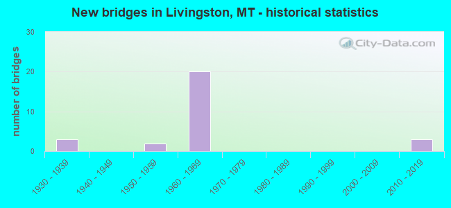
- New bridges - historical statistics
- 31930-1939
- 21950-1959
- 201960-1969
- 32010-2019

- Reconstructed bridges - Historical Statistics
- 11970-1979
- 01980-1989
- 11990-1999
- 12000-2009


- Bridge Condition - Deck
- 5.9%Very good
- 47.1%Good
- 29.4%Satisfactory
- 11.8%Fair
- 5.9%Poor

- Bridge Condition - Superstructure
- 11.8%Very good
- 23.5%Good
- 52.9%Satisfactory
- 11.8%Fair

- Bridge Condition - Substructure
- 5.9%Very good
- 23.5%Good
- 58.8%Satisfactory
- 5.9%Fair
- 5.9%Poor

- Bridge Condition - Channel
- 22.2%Very good
- 66.7%Satisfactory
- 11.1%Fair
Find on map >> Show street view
Structure Number: 201903819, Location: 6M NE OF LIVINGSTON (Lat: 45.726233, Lng: -110.462842), Route carried "on" structure: County highway 34010, Year Built: 2019, Status: Open, Structure Length: 3.23m (10.60ft), Average Daily Traffic: 100 (year 2022), Truck Traffic: 3%, Average Future Daily Traffic: 100 (year 2037), Design Load: HL 93, Features Intersected: SHEILDS RIVER, Facility Carried by Structure: CONVICT GRADE RD
Minimum Vertical Clearance: 30+ m (98+ ft), Kilometerpoint: 0.745, Lanes on structure: 2, Owner: County Highway Agency, Approaching Roadway Width: 5.5m (18.0ft), Skew: 1 degrees, Material/Design: Prestressed concrete, Design/Construction: Stringer/Multi-beam, Number Of Spans In Main Unit: 1, Length of Maximum Span: 31.4m (103.0ft), Curb-To-Curb Width: 7.5m (24.6ft), Out-to-Out Width: 8.5m (27.9ft)
Condition: Deck: Very good, Superstructure: Very good, Substructure: Very good, Channel: Satisfactory, Operating Rating: 46.3 metric tons, Method Used To Determine Operating Rating: Load and Resistance Factor (LRFR), Inventory Rating: 35.4 metric tons, Method Used To Determine Inventory Rating: Load and Resistance Factor (LRFR), Structural Evaluation: Equal to present desirable criteria, Deck Geometry: Equal to present minimum criteria, Waterway Adequacy: Equal to present desirable criteria, Approach Roadway Alignment: Equal to present desirable criteria, Designated Inspection Frequency: Every 24 months, Inspection Date: June 2021, Deck Structure Type: Other
Find on map >> Show street view
Structure Number: I00090330+09911, Location: 1.9M W LIVINGSTON (Lat: 45.651197, Lng: -110.612253), Route carried "on" structure: Interstate 90, Year Built: 1962, Status: Open, Structure Length: 3.47m (11.38ft), Average Daily Traffic: 14,046 (year 2020), Truck Traffic: 16%, Average Future Daily Traffic: 15,099 (year 2040), Design Load: HS 20, Features Intersected: INT WEST LIVINGSTON
Minimum Vertical Clearance: 30+ m (98+ ft), Kilometerpoint: 529.149, Lanes on structure: 2, Lanes under structure: 2, Base Highway Network: Yes, Owner: State Highway Agency, Approaching Roadway Width: 11.6m (38.1ft), Material/Design: Prestressed concrete, Design/Construction: Stringer/Multi-beam, Number Of Spans In Main Unit: 3, Length of Maximum Span: 12.2m (40.0ft), Curb-To-Curb Width: 11.6m (38.1ft), Out-to-Out Width: 12.7m (41.7ft)
Condition: Deck: Good, Superstructure: Satisfactory, Substructure: Good, Operating Rating: 50.8 metric tons, Method Used To Determine Operating Rating: Load Factor (LF), Inventory Rating: 41.7 metric tons, Method Used To Determine Inventory Rating: Load Factor (LF), Structural Evaluation: Equal to present minimum criteria, Deck Geometry: Equal to present minimum criteria, Underclear: High priority of corrective action, Approach Roadway Alignment: Equal to present desirable criteria, Designated Inspection Frequency: Every 24 months, Inspection Date: November 2020, Deck Structure Type: Concrete Cast-file-Place, Wearing Surface/Protective System: Wearing Surface: Bituminous, Membrane: Preformed Fabric
Find on map >> Show street view
Structure Number: I00090330+09912, Location: 1.9M W LIVINGSTON (Lat: 45.651364, Lng: -110.612122), Route carried "on" structure: Interstate 90, Year Built: 1962, Status: Open, Structure Length: 3.47m (11.38ft), Average Daily Traffic: 13,640 (year 2020), Truck Traffic: 17%, Average Future Daily Traffic: 14,663 (year 2040), Design Load: HS 20, Features Intersected: INT WEST LIVINGSTON
Minimum Vertical Clearance: 30+ m (98+ ft), Kilometerpoint: 529.353, Lanes on structure: 2, Lanes under structure: 2, Base Highway Network: Yes, Owner: State Highway Agency, Approaching Roadway Width: 11.6m (38.1ft), Material/Design: Prestressed concrete, Design/Construction: Stringer/Multi-beam, Number Of Spans In Main Unit: 3, Length of Maximum Span: 12.2m (40.0ft), Curb-To-Curb Width: 11.6m (38.1ft), Out-to-Out Width: 12.5m (41.0ft)
Condition: Deck: Good, Superstructure: Satisfactory, Substructure: Good, Operating Rating: 50.8 metric tons, Method Used To Determine Operating Rating: Load Factor (LF), Inventory Rating: 41.7 metric tons, Method Used To Determine Inventory Rating: Load Factor (LF), Structural Evaluation: Equal to present minimum criteria, Deck Geometry: Equal to present minimum criteria, Underclear: High priority of corrective action, Approach Roadway Alignment: Equal to present desirable criteria, Designated Inspection Frequency: Every 24 months, Inspection Date: November 2020, Deck Structure Type: Concrete Cast-file-Place, Wearing Surface/Protective System: Wearing Surface: Bituminous, Membrane: Preformed Fabric
Find on map >> Show street view
Structure Number: I00090332+09411, Location: LIVINGSTON (Lat: 45.644311, Lng: -110.573658), Route carried "on" structure: Interstate 90, Year Built: 1962, Status: Open, Structure Length: 7.65m (25.10ft), Average Daily Traffic: 13,640 (year 2020), Truck Traffic: 17%, Average Future Daily Traffic: 14,663 (year 2040), Design Load: HS 20, Features Intersected: INT S LIVINGSTON-US HWY
Minimum Vertical Clearance: 30+ m (98+ ft), Kilometerpoint: 532.287, Lanes on structure: 2, Lanes under structure: 2, Base Highway Network: Yes, Owner: State Highway Agency, Approaching Roadway Width: 11.6m (38.1ft), Material/Design: Prestressed concrete, Design/Construction: Stringer/Multi-beam, Number Of Spans In Main Unit: 5, Length of Maximum Span: 15.2m (49.9ft), Curb-To-Curb Width: 8.5m (27.9ft), Out-to-Out Width: 9.6m (31.5ft)
Condition: Deck: Good, Superstructure: Good, Substructure: Satisfactory, Operating Rating: 41.7 metric tons, Method Used To Determine Operating Rating: Load and Resistance Factor (LRFR), Inventory Rating: 31.8 metric tons, Method Used To Determine Inventory Rating: Load and Resistance Factor (LRFR), Structural Evaluation: Equal to present minimum criteria, Deck Geometry: High priority of corrective action, Underclear: Somewhat better than minimum adequacy, Approach Roadway Alignment: Equal to present desirable criteria, Length Of Structure Improvement: 8.70m (28.54ft), Designated Inspection Frequency: Every 24 months, Inspection Date: September 2020, Bridge Improvement Cost: $470,000, Roadway Improvement Cost: $235,000, Total Project Cost: $705,000, Deck Structure Type: Concrete Cast-file-Place, Wearing Surface/Protective System: Wearing Surface: Bituminous, Membrane: Preformed Fabric
Find on map >> Show street view
Structure Number: I00090332+09412, Location: LIVINGSTON (Lat: 45.644519, Lng: -110.573631), Route carried "on" structure: Interstate 90, Year Built: 1962, Year Reconstructed: 1981, Status: Open, Structure Length: 7.65m (25.10ft), Average Daily Traffic: 11,971 (year 2020), Truck Traffic: 16%, Average Future Daily Traffic: 13,108 (year 2040), Design Load: HS 20, Features Intersected: INT S LIVINGSTON-US HWY
Minimum Vertical Clearance: 30+ m (98+ ft), Kilometerpoint: 532.479, Lanes on structure: 2, Lanes under structure: 2, Base Highway Network: Yes, Owner: State Highway Agency, Approaching Roadway Width: 12.8m (42.0ft), Material/Design: Prestressed concrete, Design/Construction: Stringer/Multi-beam, Number Of Spans In Main Unit: 5, Length of Maximum Span: 15.8m (51.8ft), Curb-To-Curb Width: 12.2m (40.0ft), Out-to-Out Width: 13.4m (44.0ft)
Condition: Deck: Satisfactory, Superstructure: Very good, Substructure: Satisfactory, Operating Rating: 49.0 metric tons, Method Used To Determine Operating Rating: Load and Resistance Factor (LRFR), Inventory Rating: 38.1 metric tons, Method Used To Determine Inventory Rating: Load and Resistance Factor (LRFR), Structural Evaluation: Equal to present minimum criteria, Deck Geometry: Better than present minimum criteria, Underclear: Somewhat better than minimum adequacy, Approach Roadway Alignment: Equal to present desirable criteria, Designated Inspection Frequency: Every 48 months, Inspection Date: September 2018, Deck Structure Type: Concrete Cast-file-Place
Find on map >> Show street view
Structure Number: I00090333+05521, Location: LIVINGSTON (Lat: 45.644367, Lng: -110.561144), Route carried "on" structure: Interstate 90, Year Built: 1962, Status: Open, Structure Length: 22.25m (73.00ft), Average Daily Traffic: 11,971 (year 2020), Truck Traffic: 16%, Average Future Daily Traffic: 13,108 (year 2040), Design Load: HS 20, Features Intersected: YELLOWSTONE RIVER
Minimum Vertical Clearance: 30+ m (98+ ft), Kilometerpoint: 533.262, Lanes on structure: 2, Lanes under structure: 2, Base Highway Network: Yes, Owner: State Highway Agency, Approaching Roadway Width: 11.6m (38.1ft), Material/Design: Steel continuous, Design/Construction: Girder and Floorbeam System, Number Of Spans In Main Unit: 4, Number Of Approach Spans: 1, Length of Maximum Span: 56.4m (185.0ft), Curb-To-Curb Width: 8.5m (27.9ft), Out-to-Out Width: 9.7m (31.8ft)
Condition: Deck: Satisfactory, Superstructure: Satisfactory, Substructure: Satisfactory, Channel: Satisfactory, Operating Rating: 48.1 metric tons, Method Used To Determine Operating Rating: Load Factor (LF), Inventory Rating: 29.0 metric tons, Method Used To Determine Inventory Rating: Load Factor (LF), Structural Evaluation: Equal to present minimum criteria, Deck Geometry: High priority of corrective action, Waterway Adequacy: Equal to present minimum criteria, Approach Roadway Alignment: Equal to present desirable criteria, Length Of Structure Improvement: 22.25m (73.00ft), Designated Inspection Frequency: Every 24 months, Critical Feature Inspection Frequency: Every 24 months, Underwater Inspection Frequency: Every 60 months, Inspection Date: September 2020, Critical Feature Inspection Date: September 2020, Underwater Inspection Date: October 2018, Bridge Improvement Cost: $1,380,000, Roadway Improvement Cost: $690,000, Total Project Cost: $2,070,000, Deck Structure Type: Concrete Cast-file-Place, Wearing Surface/Protective System: Wearing Surface: Epoxy Overlay
Find on map >> Show street view
Structure Number: I00090333+05522, Location: LIVINGSTON (Lat: 45.644558, Lng: -110.561172), Route carried "on" structure: Interstate 90, Year Built: 1962, Status: Open, Structure Length: 22.25m (73.00ft), Average Daily Traffic: 11,971 (year 2020), Truck Traffic: 16%, Average Future Daily Traffic: 13,108 (year 2040), Design Load: HS 20, Features Intersected: YELLOWSTONE RIVER
Minimum Vertical Clearance: 5.36m (17.59ft), Kilometerpoint: 533.451, Lanes on structure: 2, Lanes under structure: 2, Base Highway Network: Yes, Owner: State Highway Agency, Approaching Roadway Width: 11.6m (38.1ft), Material/Design: Steel continuous, Design/Construction: Girder and Floorbeam System, Number Of Spans In Main Unit: 4, Number Of Approach Spans: 1, Length of Maximum Span: 56.4m (185.0ft), Curb-To-Curb Width: 8.5m (27.9ft), Out-to-Out Width: 9.7m (31.8ft)
Condition: Deck: Good, Superstructure: Satisfactory, Substructure: Satisfactory, Channel: Satisfactory, Operating Rating: 48.1 metric tons, Method Used To Determine Operating Rating: Load Factor (LF), Inventory Rating: 29.0 metric tons, Method Used To Determine Inventory Rating: Load Factor (LF), Structural Evaluation: Equal to present minimum criteria, Deck Geometry: High priority of corrective action, Waterway Adequacy: Equal to present desirable criteria, Approach Roadway Alignment: Equal to present desirable criteria, Length Of Structure Improvement: 22.39m (73.46ft), Designated Inspection Frequency: Every 24 months, Critical Feature Inspection Frequency: Every 24 months, Underwater Inspection Frequency: Every 60 months, Inspection Date: June 2021, Critical Feature Inspection Date: June 2021, Underwater Inspection Date: October 2018, Bridge Improvement Cost: $1,380,000, Roadway Improvement Cost: $690,000, Total Project Cost: $2,070,000, Deck Structure Type: Concrete Cast-file-Place, Wearing Surface/Protective System: Wearing Surface: Epoxy Overlay
Find on map >> Show street view
Structure Number: I00090336+08901, Location: 3.7M E LIVINGSTON (Lat: 45.677175, Lng: -110.513336), Route carried "on" structure: Interstate 90, Year Built: 1962, Status: Open, Structure Length: 3.90m (12.80ft), Average Daily Traffic: 11,971 (year 2020), Truck Traffic: 16%, Average Future Daily Traffic: 13,108 (year 2040), Design Load: HS 20, Features Intersected: SEP S 295
Minimum Vertical Clearance: 30+ m (98+ ft), Kilometerpoint: 538.671, Lanes on structure: 2, Lanes under structure: 2, Base Highway Network: Yes, Owner: State Highway Agency, Approaching Roadway Width: 12.2m (40.0ft), Material/Design: Prestressed concrete, Design/Construction: Stringer/Multi-beam, Number Of Spans In Main Unit: 3, Length of Maximum Span: 15.2m (49.9ft), Curb-To-Curb Width: 11.6m (38.1ft), Out-to-Out Width: 12.5m (41.0ft)
Condition: Deck: Good, Superstructure: Satisfactory, Substructure: Good, Operating Rating: 56.2 metric tons, Method Used To Determine Operating Rating: Load and Resistance Factor (LRFR), Inventory Rating: 43.5 metric tons, Method Used To Determine Inventory Rating: Load and Resistance Factor (LRFR), Structural Evaluation: Equal to present minimum criteria, Deck Geometry: Equal to present minimum criteria, Underclear: Meets minimum limits, Approach Roadway Alignment: Equal to present desirable criteria, Designated Inspection Frequency: Every 24 months, Inspection Date: December 2020, Deck Structure Type: Concrete Cast-file-Place, Wearing Surface/Protective System: Wearing Surface: Bituminous, Membrane: Preformed Fabric
Find on map >> Show street view
Structure Number: I00090336+08902, Location: 3.7M E LIVINGSTON (Lat: 45.677325, Lng: -110.513531), Route carried "on" structure: Interstate 90, Year Built: 1962, Status: Open, Structure Length: 3.90m (12.80ft), Average Daily Traffic: 11,971 (year 2020), Truck Traffic: 16%, Average Future Daily Traffic: 13,108 (year 2040), Design Load: HS 20, Features Intersected: SEP S 295
Minimum Vertical Clearance: 30+ m (98+ ft), Kilometerpoint: 538.841, Lanes on structure: 2, Lanes under structure: 2, Base Highway Network: Yes, Owner: State Highway Agency, Approaching Roadway Width: 12.2m (40.0ft), Material/Design: Prestressed concrete, Design/Construction: Stringer/Multi-beam, Number Of Spans In Main Unit: 3, Length of Maximum Span: 15.2m (49.9ft), Curb-To-Curb Width: 11.6m (38.1ft), Out-to-Out Width: 12.5m (41.0ft)
Condition: Deck: Satisfactory, Superstructure: Good, Substructure: Satisfactory, Operating Rating: 56.2 metric tons, Method Used To Determine Operating Rating: Load and Resistance Factor (LRFR), Inventory Rating: 43.5 metric tons, Method Used To Determine Inventory Rating: Load and Resistance Factor (LRFR), Structural Evaluation: Equal to present minimum criteria, Deck Geometry: Equal to present minimum criteria, Underclear: Meets minimum limits, Approach Roadway Alignment: Equal to present desirable criteria, Designated Inspection Frequency: Every 24 months, Inspection Date: December 2020, Deck Structure Type: Concrete Cast-file-Place
Find on map >> Show street view
Structure Number: L34003001+07001, Location: 2M NE LIVINGSTON (Lat: 45.701478, Lng: -110.519742), Route carried "on" structure: County highway 34003, Year Built: 1938, Status: Open, Structure Length: 1.55m (5.09ft), Average Daily Traffic: 627 (year 2020), Truck Traffic: 3%, Average Future Daily Traffic: 658 (year 2040), Features Intersected: FERRY CREEK 037, Facility Carried by Structure: OLD CLYDE PARK RD
Minimum Vertical Clearance: 30+ m (98+ ft), Kilometerpoint: 6.106, Lanes on structure: 2, Owner: County Highway Agency, Approaching Roadway Width: 6.1m (20.0ft), Material/Design: Concrete, Design/Construction: Slab, Number Of Spans In Main Unit: 3, Length of Maximum Span: 4.9m (16.1ft), Curb or Sidewalk Widths: Left: 0.2m (0.7ft), Right: 0.2m (0.7ft), Curb-To-Curb Width: 6.1m (20.0ft), Out-to-Out Width: 7.8m (25.6ft)
Condition: Deck: Fair, Superstructure: Fair, Substructure: Fair, Channel: Satisfactory, Operating Rating: 24.4 metric tons, Method Used To Determine Operating Rating: Allowable Stress (AS), Inventory Rating: 24.4 metric tons, Method Used To Determine Inventory Rating: Allowable Stress (AS), Structural Evaluation: Somewhat better than minimum adequacy, Deck Geometry: High priority of corrective action, Waterway Adequacy: Equal to present desirable criteria, Approach Roadway Alignment: Equal to present desirable criteria, Designated Inspection Frequency: Every 24 months, Inspection Date: June 2021, Deck Structure Type: Concrete Cast-file-Place, Wearing Surface/Protective System: Wearing Surface: Bituminous
Find on map >> Show street view
Structure Number: L34007000+03001, Location: 8M NE LIVINGSTON (Lat: 45.761817, Lng: -110.493806), Route carried "on" structure: County highway 34007, Year Built: 1938, Year Reconstructed: 1997, Status: Open, Structure Length: 0.70m (2.30ft), Average Daily Traffic: 100 (year 2022), Truck Traffic: 3%, Average Future Daily Traffic: 100 (year 2037), Features Intersected: SHIELDS RIVER OVERFL 022, Facility Carried by Structure: SHIELDS RIVER RD E
Minimum Vertical Clearance: 30+ m (98+ ft), Kilometerpoint: 0.432, Lanes on structure: 2, Owner: County Highway Agency, Approaching Roadway Width: 5.5m (18.0ft), Material/Design: Steel, Design/Construction: Stringer/Multi-beam, Number Of Spans In Main Unit: 1, Length of Maximum Span: 7.0m (23.0ft), Curb-To-Curb Width: 6.6m (21.7ft), Out-to-Out Width: 6.8m (22.3ft)
Condition: Deck: Good, Superstructure: Satisfactory, Substructure: Poor, Channel: Satisfactory, Operating Rating: 33.6 metric tons, Method Used To Determine Operating Rating: Load Factor (LF), Inventory Rating: 20.0 metric tons, Method Used To Determine Inventory Rating: Load Factor (LF), Structural Evaluation: Meets minimum limits, Deck Geometry: Somewhat better than minimum adequacy, Waterway Adequacy: Equal to present minimum criteria, Approach Roadway Alignment: Equal to present desirable criteria, Designated Inspection Frequency: Every 24 months, Inspection Date: January 2022, Deck Structure Type: Corrugated Steel, Wearing Surface/Protective System: Wearing Surface: Gravel
Find on map >> Show street view
Structure Number: L34391000+01001, Location: LIVINGSTON-S 9TH ST (Lat: 45.649936, Lng: -110.561942), Route carried "on" structure: County highway 34391, Year Built: 2011, Status: Open, Structure Length: 6.14m (20.14ft), Average Daily Traffic: 92 (year 2020), Truck Traffic: 3%, Average Future Daily Traffic: 97 (year 2040), Design Load: HL 93, Features Intersected: YELLOWSTONE RIVER 070, Facility Carried by Structure: S 9TH ST-ISLAND DR
Minimum Vertical Clearance: 30+ m (98+ ft), Kilometerpoint: 0.066, Lanes on structure: 1, Owner: County Highway Agency, Approaching Roadway Width: 6.1m (20.0ft), Material/Design: Prestressed concrete, Design/Construction: Tee Beam, Number Of Spans In Main Unit: 2, Length of Maximum Span: 30.7m (100.7ft), Curb-To-Curb Width: 4.3m (14.1ft), Out-to-Out Width: 6.2m (20.3ft)
Condition: Deck: Good, Superstructure: Good, Substructure: Satisfactory, Channel: Very good, Operating Rating: 45.1 metric tons, Method Used To Determine Operating Rating: Load and Resistance Factor (LRFR), Inventory Rating: 34.7 metric tons, Method Used To Determine Inventory Rating: Load and Resistance Factor (LRFR), Structural Evaluation: Equal to present minimum criteria, Deck Geometry: Equal to present minimum criteria, Waterway Adequacy: Equal to present minimum criteria, Approach Roadway Alignment: Equal to present minimum criteria, Length Of Structure Improvement: 6.50m (21.33ft), Designated Inspection Frequency: Every 24 months, Inspection Date: Febuary 2021, Bridge Improvement Cost: $227,000, Roadway Improvement Cost: $114,000, Total Project Cost: $341,000, Deck Structure Type: Other
Find on map >> Show street view
Structure Number: M34074000+00101, Location: LIVINGSTON-SACAGAWEA PARK (Lat: 45.655053, Lng: -110.558669), Route carried "on" structure: City street 34074, Year Built: 1939, Status: Open, Structure Length: 1.95m (6.40ft), Average Daily Traffic: 100 (year 2022), Truck Traffic: 3%, Average Future Daily Traffic: 100 (year 2037), Features Intersected: FLESHMAN CREEK 071, Facility Carried by Structure: S YELLOWSTONE ST
Minimum Vertical Clearance: 30+ m (98+ ft), Kilometerpoint: 0.210, Lanes on structure: 2, Owner: City or Municipal Highway Agency, Approaching Roadway Width: 10.4m (34.1ft), Material/Design: Steel, Design/Construction: Culvert, Number Of Spans In Main Unit: 3, Length of Maximum Span: 7.9m (25.9ft), Curb or Sidewalk Widths: Left: 1.5m (4.9ft), Right: 1.5m (4.9ft), Curb-To-Curb Width: 7.4m (24.3ft), Out-to-Out Width: 7.6m (24.9ft)
Condition: Channel: Very good, Culverts: Good, Operating Rating: 44.5 metric tons, Method Used To Determine Operating Rating: Load and Resistance Factor (LRFR), Inventory Rating: 32.7 metric tons, Method Used To Determine Inventory Rating: Load and Resistance Factor (LRFR), Structural Evaluation: Better than present minimum criteria, Deck Geometry: Equal to present minimum criteria, Waterway Adequacy: Equal to present desirable criteria, Approach Roadway Alignment: Equal to present desirable criteria, Designated Inspection Frequency: Every 24 months, Inspection Date: May 2021
Find on map >> Show street view
Structure Number: P00011055+09401, Location: NE LIVINGSTON (Lat: 45.674811, Lng: -110.536967), Route carried "on" structure: US 89, Year Built: 2013, Status: Open, Structure Length: 19.56m (64.17ft), Average Daily Traffic: 4,522 (year 2020), Truck Traffic: 2%, Average Future Daily Traffic: 4,748 (year 2040), Design Load: HL 93, Features Intersected: YELLOWSTONE RIVER, Facility Carried by Structure: BUSINESS RTE 90
Minimum Vertical Clearance: 30+ m (98+ ft), Kilometerpoint: 89.813, Lanes on structure: 2, Base Highway Network: Yes, Owner: State Highway Agency, Approaching Roadway Width: 12.2m (40.0ft), Material/Design: Steel continuous, Design/Construction: Stringer/Multi-beam, Number Of Spans In Main Unit: 4, Length of Maximum Span: 54.3m (178.1ft), Curb or Sidewalk Widths: Left: 0.0m, Right: 3.0m (9.8ft), Curb-To-Curb Width: 12.2m (40.0ft), Out-to-Out Width: 16.6m (54.5ft)
Condition: Deck: Satisfactory, Superstructure: Good, Substructure: Good, Channel: Fair, Operating Rating: 45.4 metric tons, Method Used To Determine Operating Rating: Load and Resistance Factor (LRFR), Inventory Rating: 34.5 metric tons, Method Used To Determine Inventory Rating: Load and Resistance Factor (LRFR), Structural Evaluation: Better than present minimum criteria, Deck Geometry: Equal to present minimum criteria, Waterway Adequacy: Better than present minimum criteria, Approach Roadway Alignment: Equal to present desirable criteria, Designated Inspection Frequency: Every 24 months, Underwater Inspection Frequency: Every 60 months, Inspection Date: May 2021, Underwater Inspection Date: August 2020, Deck Structure Type: Concrete Cast-file-Place, Wearing Surface/Protective System: Deck Protection: Epoxy Coated Reinforcing
Find on map >> Show street view
Structure Number: P00011057+09501, Location: 2M NE LIVNGSTON (Lat: 45.688106, Lng: -110.500358), Route carried "on" structure: US 89, Year Built: 1962, Status: Open, Structure Length: 8.50m (27.89ft), Average Daily Traffic: 2,506 (year 2020), Truck Traffic: 3%, Average Future Daily Traffic: 2,631 (year 2040), Design Load: H 20, Features Intersected: INT EAST LIVINGSTON I 90
Minimum Vertical Clearance: 30+ m (98+ ft), Kilometerpoint: 93.060, Lanes on structure: 2, Lanes under structure: 4, Base Highway Network: Yes, Owner: State Highway Agency, Approaching Roadway Width: 11.0m (36.1ft), Skew: 3 degrees, Material/Design: Steel continuous, Design/Construction: Stringer/Multi-beam, Number Of Spans In Main Unit: 4, Length of Maximum Span: 23.6m (77.4ft), Curb-To-Curb Width: 8.5m (27.9ft), Out-to-Out Width: 9.7m (31.8ft)
Condition: Deck: Poor, Superstructure: Satisfactory, Substructure: Satisfactory, Operating Rating: 30.8 metric tons, Method Used To Determine Operating Rating: Load and Resistance Factor (LRFR), Inventory Rating: 23.6 metric tons, Method Used To Determine Inventory Rating: Load and Resistance Factor (LRFR), Structural Evaluation: Equal to present minimum criteria, Deck Geometry: Meets minimum limits, Underclear: High priority of replacement, Approach Roadway Alignment: Equal to present minimum criteria, Length Of Structure Improvement: 9.50m (31.17ft), Designated Inspection Frequency: Every 24 months, Inspection Date: August 2021, Bridge Improvement Cost: $525,000, Roadway Improvement Cost: $263,000, Total Project Cost: $788,000, Deck Structure Type: Concrete Cast-file-Place, Wearing Surface/Protective System: Wearing Surface: Monolithic Concrete, Deck Protection: Bituminous
Find on map >> Show street view
Structure Number: P00059000+00001, Location: 5M NE LIVINGSTON (Lat: 45.706750, Lng: -110.455256), Route carried "on" structure: US 89, Year Built: 1962, Status: Open, Structure Length: 6.43m (21.10ft), Average Daily Traffic: 2,006 (year 2020), Truck Traffic: 3%, Average Future Daily Traffic: 2,156 (year 2040), Design Load: HS 20, Features Intersected: INT MISSION I 90
Minimum Vertical Clearance: 30+ m (98+ ft), Kilometerpoint: 0.010, Lanes on structure: 2, Lanes under structure: 4, Base Highway Network: Yes, Owner: State Highway Agency, Approaching Roadway Width: 9.8m (32.2ft), Material/Design: Prestressed concrete, Design/Construction: Stringer/Multi-beam, Number Of Spans In Main Unit: 4, Length of Maximum Span: 18.3m (60.0ft), Curb-To-Curb Width: 8.5m (27.9ft), Out-to-Out Width: 9.5m (31.2ft)
Condition: Deck: Fair, Superstructure: Satisfactory, Substructure: Satisfactory, Operating Rating: 48.1 metric tons, Method Used To Determine Operating Rating: Load and Resistance Factor (LRFR), Inventory Rating: 37.2 metric tons, Method Used To Determine Inventory Rating: Load and Resistance Factor (LRFR), Structural Evaluation: Equal to present minimum criteria, Deck Geometry: Meets minimum limits, Underclear: High priority of corrective action, Approach Roadway Alignment: Equal to present desirable criteria, Designated Inspection Frequency: Every 24 months, Inspection Date: Febuary 2021, Deck Structure Type: Concrete Cast-file-Place, Wearing Surface/Protective System: Deck Protection: Bituminous
Find on map >> Show street view
Structure Number: P00059000+00611, Location: 5M NE LIVINGSTON (Lat: 45.707603, Lng: -110.455919), Route carried "on" structure: US 89, Year Built: 1955, Status: Open, Structure Length: 3.93m (12.89ft), Average Daily Traffic: 2,006 (year 2020), Truck Traffic: 3%, Average Future Daily Traffic: 2,156 (year 2040), Design Load: HS 15, Features Intersected: RR
Minimum Vertical Clearance: 30+ m (98+ ft), Kilometerpoint: 0.127, Lanes on structure: 2, Base Highway Network: Yes, Owner: State Highway Agency, Approaching Roadway Width: 8.5m (27.9ft), Material/Design: Concrete, Design/Construction: Tee Beam, Number Of Spans In Main Unit: 3, Length of Maximum Span: 14.2m (46.6ft), Curb-To-Curb Width: 8.5m (27.9ft), Out-to-Out Width: 10.1m (33.1ft)
Condition: Deck: Good, Superstructure: Fair, Substructure: Satisfactory, Operating Rating: 29.9 metric tons, Method Used To Determine Operating Rating: Load and Resistance Factor (LRFR), Inventory Rating: 20.9 metric tons, Method Used To Determine Inventory Rating: Load and Resistance Factor (LRFR), Structural Evaluation: Somewhat better than minimum adequacy, Deck Geometry: Meets minimum limits, Underclear: Equal to present minimum criteria, Approach Roadway Alignment: Equal to present minimum criteria, Designated Inspection Frequency: Every 24 months, Inspection Date: June 2021, Deck Structure Type: Concrete Cast-file-Place, Wearing Surface/Protective System: Wearing Surface: Bituminous, Membrane: Preformed Fabric
Find on map >> Show street view
Structure Number: P00059001+05131, Location: 6M NE LIVINGSTON (Lat: 45.717961, Lng: -110.467503), Route carried "on" structure: US 89, Year Built: 1955, Year Reconstructed: 2011, Status: Open, Structure Length: 12.01m (39.40ft), Average Daily Traffic: 2,006 (year 2020), Truck Traffic: 3%, Average Future Daily Traffic: 2,156 (year 2040), Design Load: HS 15, Features Intersected: YELLOWSTONE RIVER
Minimum Vertical Clearance: 30+ m (98+ ft), Kilometerpoint: 1.588, Lanes on structure: 2, Base Highway Network: Yes, Owner: State Highway Agency, Approaching Roadway Width: 8.5m (27.9ft), Material/Design: Steel continuous, Design/Construction: Stringer/Multi-beam, Number Of Spans In Main Unit: 4, Length of Maximum Span: 32.9m (107.9ft), Curb-To-Curb Width: 8.5m (27.9ft), Out-to-Out Width: 10.2m (33.5ft)
Condition: Deck: Satisfactory, Superstructure: Satisfactory, Substructure: Satisfactory, Channel: Satisfactory, Operating Rating: 36.3 metric tons, Method Used To Determine Operating Rating: Load Factor (LF), Inventory Rating: 20.0 metric tons, Method Used To Determine Inventory Rating: Load Factor (LF), Structural Evaluation: Somewhat better than minimum adequacy, Deck Geometry: Meets minimum limits, Waterway Adequacy: Equal to present desirable criteria, Approach Roadway Alignment: Equal to present desirable criteria, Length Of Structure Improvement: 12.90m (42.32ft), Designated Inspection Frequency: Every 24 months, Underwater Inspection Frequency: Every 60 months, Inspection Date: May 2021, Underwater Inspection Date: August 2020, Bridge Improvement Cost: $1,127,000, Roadway Improvement Cost: $564,000, Total Project Cost: $1,691,000, Deck Structure Type: Concrete Cast-file-Place
Find on map >> Show street view
Structure Number: I00090330+09911, Location: 19M W LIVINGSTON (Lat: 45.651197, Lng: -110.612253), Route carried "under" structure: ServiceCounty highway 34372, Year Built: 1962, Structure Length: 0. m, Average Daily Traffic: 4,234 (year 2020), Truck Traffic: 1%, Features Intersected: INT WEST LIVINGSTON, Facility Carried by Structure: I 90
Minimum Vertical Clearance: 4.39m (14.40ft), Kilometerpoint: 3.761, Lanes on structure: 2, Lanes under structure: 2, Material/Design: Prestressed concrete, Design/Construction: Stringer/Multi-beam, Length of Maximum Span: 12.2m (40.0ft)
Find on map >> Show street view
Structure Number: I00090330+09912, Location: 19M W LIVINGSTON (Lat: 45.651364, Lng: -110.612122), Route carried "under" structure: ServiceCounty highway 7408, Year Built: 1962, Structure Length: 0. m, Average Daily Traffic: 4,234 (year 2020), Truck Traffic: 1%, Features Intersected: INT WEST LIVINGSTON, Facility Carried by Structure: I 90
Minimum Vertical Clearance: 4.39m (14.40ft), Kilometerpoint: 3.739, Lanes on structure: 2, Lanes under structure: 2, Material/Design: Prestressed concrete, Design/Construction: Stringer/Multi-beam, Length of Maximum Span: 12.2m (40.0ft)
Find on map >> Show street view
Structure Number: I00090332+09411, Location: LIVINGSTON (Lat: 45.644311, Lng: -110.573658), Route carried "under" structure: US 89, Year Built: 1962, Structure Length: 0. m, Average Daily Traffic: 13,634 (year 2020), Truck Traffic: 1%, Features Intersected: INT S LIVINGSTON-US HWY, Facility Carried by Structure: I 90
Minimum Vertical Clearance: 5.48m (17.98ft), Kilometerpoint: 85.138, Lanes on structure: 2, Lanes under structure: 2, Material/Design: Prestressed concrete, Design/Construction: Stringer/Multi-beam, Length of Maximum Span: 15.2m (49.9ft)
Find on map >> Show street view
Structure Number: I00090332+09412, Location: LIVINGSTON (Lat: 45.644519, Lng: -110.573631), Route carried "under" structure: US 89, Year Built: 1962, Structure Length: 0. m, Average Daily Traffic: 11,779 (year 2020), Truck Traffic: 1%, Features Intersected: INT S LIVINGSTON-US HWY, Facility Carried by Structure: I 90
Minimum Vertical Clearance: 5.48m (17.98ft), Kilometerpoint: 85.161, Lanes on structure: 2, Lanes under structure: 2, Material/Design: Prestressed concrete, Design/Construction: Stringer/Multi-beam, Length of Maximum Span: 15.8m (51.8ft)
Find on map >> Show street view
Structure Number: I00090333+05521, Location: LIVINGSTON (Lat: 45.644367, Lng: -110.561144), Route carried "under" structure: County highway 34757, Year Built: 1962, Structure Length: 0. m, Average Daily Traffic: 92 (year 2020), Truck Traffic: 3%, Features Intersected: YELLOWSTONE RIVER, Facility Carried by Structure: I 90
Minimum Vertical Clearance: 4.42m (14.50ft), Kilometerpoint: 0.744, Lanes on structure: 2, Lanes under structure: 2, Material/Design: Steel continuous, Design/Construction: Girder and Floorbeam System, Length of Maximum Span: 56.4m (185.0ft)
Find on map >> Show street view
Structure Number: I00090333+05522, Location: LIVINGSTON (Lat: 45.644558, Lng: -110.561172), Route carried "under" structure: City street 34757, Year Built: 1962, Structure Length: 0. m, Average Daily Traffic: 92 (year 2020), Truck Traffic: 3%, Features Intersected: YELLOWSTONE RIVER, Facility Carried by Structure: I 90
Minimum Vertical Clearance: 4.42m (14.50ft), Kilometerpoint: 0.725, Lanes on structure: 2, Lanes under structure: 2, Material/Design: Steel continuous, Design/Construction: Girder and Floorbeam System, Length of Maximum Span: 56.4m (185.0ft)
Find on map >> Show street view
Structure Number: I00090336+08901, Location: 37M E LIVINGSTON (Lat: 45.677175, Lng: -110.513336), Route carried "under" structure: State highway 295, Year Built: 1962, Structure Length: 0. m, Average Daily Traffic: 883 (year 2020), Truck Traffic: 7%, Features Intersected: SEP S 295, Facility Carried by Structure: I 90
Minimum Vertical Clearance: 4.57m (14.99ft), Kilometerpoint: 0.708, Lanes on structure: 2, Lanes under structure: 2, Material/Design: Prestressed concrete, Design/Construction: Stringer/Multi-beam, Length of Maximum Span: 15.2m (49.9ft)
Find on map >> Show street view
Structure Number: I00090336+08902, Location: 37M E LIVINGSTON (Lat: 45.677325, Lng: -110.513531), Route carried "under" structure: State highway 295, Year Built: 1962, Structure Length: 0. m, Average Daily Traffic: 883 (year 2020), Truck Traffic: 7%, Features Intersected: SEP S 295, Facility Carried by Structure: I 90
Minimum Vertical Clearance: 4.57m (14.99ft), Kilometerpoint: 0.685, Lanes on structure: 2, Lanes under structure: 2, Material/Design: Prestressed concrete, Design/Construction: Stringer/Multi-beam, Length of Maximum Span: 15.2m (49.9ft)
Find on map >> Show street view
Structure Number: P00011057+09501, Location: 2M NE LIVNGSTON (Lat: 45.688106, Lng: -110.500358), Route carried "under" structure: Interstate 90, Year Built: 1962, Structure Length: 0. m, Average Daily Traffic: 11,971 (year 2020), Truck Traffic: 16%, Features Intersected: INT EAST LIVINGSTON I 90, Facility Carried by Structure: US 89
Minimum Vertical Clearance: 5.18m (16.99ft), Kilometerpoint: 540.256, Lanes on structure: 2, Lanes under structure: 4, Material/Design: Steel continuous, Design/Construction: Stringer/Multi-beam, Length of Maximum Span: 23.6m (77.4ft)
Find on map >> Show street view
Structure Number: P00059000+00001, Location: 5M NE LIVINGSTON (Lat: 45.706750, Lng: -110.455256), Route carried "under" structure: Interstate 90, Year Built: 1962, Structure Length: 0. m, Average Daily Traffic: 12,455 (year 2020), Truck Traffic: 17%, Features Intersected: INT MISSION I 90, Facility Carried by Structure: US 89
Minimum Vertical Clearance: 5.28m (17.32ft), Kilometerpoint: 544.328, Lanes on structure: 2, Lanes under structure: 4, Material/Design: Prestressed concrete, Design/Construction: Stringer/Multi-beam, Length of Maximum Span: 18.3m (60.0ft)