Bridge Statistics for Livingston, California (CA)
Condition, Traffic, Stress, Structural Evaluation, Project Costs
- National Bridge Inventory (NBI) Statistics
- 19Number of bridges
- 236ft / 72.0mTotal length
- $397,000Total costs
- 332,062Total average daily traffic
- 22,854Total average daily truck traffic
- National Bridge Inventory (NBI) Registered Bridges for Livingston
- No street view available for this location
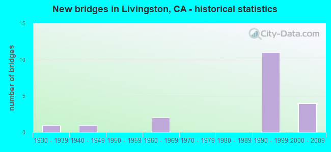
- New bridges - historical statistics
- 11930-1939
- 11940-1949
- 21960-1969
- 111990-1999
- 42000-2009


- Bridge Condition - Deck
- 46.2%Good
- 38.5%Satisfactory
- 7.7%Fair
- 7.7%Poor

- Bridge Condition - Superstructure
- 84.6%Good
- 7.7%Satisfactory
- 7.7%Poor

- Bridge Condition - Substructure
- 69.2%Good
- 7.7%Satisfactory
- 15.4%Fair
- 7.7%Poor

- Bridge Condition - Channel
- 14.3%Excellent
- 42.9%Very good
- 42.9%Good
Find on map >> Show street view
Structure Number: 39 0015L, Location: 10-MER-099-R31.00 (Lat: 37.398947, Lng: -120.742611), Route carried "on" structure: State highway 99, Year Built: 1997, Status: Open, Structure Length: 11.50m (37.73ft), Average Daily Traffic: 23,000 (year 2009), Average Future Daily Traffic: 36,600 (year 2040), Design Load: HS 20+Mod, Features Intersected: MERCED RIVER
Minimum Vertical Clearance: 30+ m (98+ ft), Kilometerpoint: 31.000, Lanes on structure: 2, Base Highway Network: Yes (, Subroute: 1), Owner: State Highway Agency, Approaching Roadway Width: 20.8m (68.2ft), Skew: 1 degrees, Material/Design: Prestressed concrete continuous, Design/Construction: Box Beam or Girders - Multiple, Number Of Spans In Main Unit: 2, Length of Maximum Span: 64.8m (212.6ft), Curb or Sidewalk Widths: Left: 2.4m (7.9ft), Right: 0.0m, Curb-To-Curb Width: 17.1m (56.1ft), Out-to-Out Width: 20.8m (68.2ft)
Condition: Deck: Satisfactory, Superstructure: Good, Substructure: Good, Channel: Very good, Operating Rating: 54.1 metric tons, Method Used To Determine Operating Rating: Assigned rating based on Load Factor Design (LFD) reported in metric tons, Inventory Rating: 32.4 metric tons, Method Used To Determine Inventory Rating: Assigned rating based on Load Factor Design (LFD) reported in metric tons, Structural Evaluation: Better than present minimum criteria, Deck Geometry: Superior to present desirable criteria, Waterway Adequacy: Superior to present desirable criteria, Approach Roadway Alignment: Equal to present desirable criteria, Designated Inspection Frequency: Every 24 months, Inspection Date: May 2020, Deck Structure Type: Concrete Cast-file-Place
Find on map >> Show street view
Structure Number: 39 0015R, Location: 10-MER-099-R30.97 (Lat: 37.399097, Lng: -120.742292), Route carried "on" structure: State highway 99, Year Built: 1999, Status: Open, Structure Length: 11.37m (37.30ft), Average Daily Traffic: 23,000 (year 2009), Average Future Daily Traffic: 36,600 (year 2040), Design Load: HS 20+Mod, Features Intersected: MERCED RIVER
Minimum Vertical Clearance: 30+ m (98+ ft), Kilometerpoint: 30.970, Lanes on structure: 2, Base Highway Network: Yes (, Subroute: 1), Owner: State Highway Agency, Approaching Roadway Width: 11.8m (38.7ft), Material/Design: Prestressed concrete continuous, Design/Construction: Box Beam or Girders - Multiple, Number Of Spans In Main Unit: 2, Length of Maximum Span: 63.4m (208.0ft), Curb-To-Curb Width: 11.8m (38.7ft), Out-to-Out Width: 12.8m (42.0ft)
Condition: Deck: Satisfactory, Superstructure: Good, Substructure: Good, Channel: Excellent, Operating Rating: 54.1 metric tons, Method Used To Determine Operating Rating: Assigned rating based on Load Factor Design (LFD) reported in metric tons, Inventory Rating: 32.4 metric tons, Method Used To Determine Inventory Rating: Assigned rating based on Load Factor Design (LFD) reported in metric tons, Structural Evaluation: Better than present minimum criteria, Deck Geometry: Better than present minimum criteria, Waterway Adequacy: Superior to present desirable criteria, Approach Roadway Alignment: Equal to present desirable criteria, Designated Inspection Frequency: Every 24 months, Inspection Date: May 2020, Deck Structure Type: Concrete Cast-file-Place
Find on map >> Show street view
Structure Number: 39 0218, Location: 10-MER-099-27.10 (Lat: 37.373669, Lng: -120.682300), Route carried "on" structure: City street , Year Built: 2007, Status: Open, Structure Length: 8.48m (27.82ft), Average Daily Traffic: 800 (year 1998), Truck Traffic: 4%, Average Future Daily Traffic: 1,304 (year 2040), Design Load: HS 20, Features Intersected: STATE ROUTE 99, Facility Carried by Structure: SULTANA DRIVE
Minimum Vertical Clearance: 30+ m (98+ ft), Kilometerpoint: 0.000, Lanes on structure: 2, Lanes under structure: 6, Owner: State Highway Agency, Approaching Roadway Width: 15.7m (51.5ft), Skew: 3 degrees, Material/Design: Prestressed concrete continuous, Design/Construction: Box Beam or Girders - Multiple, Number Of Spans In Main Unit: 2, Length of Maximum Span: 44.1m (144.7ft), Curb-To-Curb Width: 15.7m (51.5ft), Out-to-Out Width: 16.4m (53.8ft)
Condition: Deck: Good, Superstructure: Good, Substructure: Good, Operating Rating: 54.1 metric tons, Method Used To Determine Operating Rating: Assigned rating based on Load Factor Design (LFD) reported in metric tons, Inventory Rating: 32.4 metric tons, Method Used To Determine Inventory Rating: Assigned rating based on Load Factor Design (LFD) reported in metric tons, Structural Evaluation: Better than present minimum criteria, Deck Geometry: Superior to present desirable criteria, Underclear: Somewhat better than minimum adequacy, Approach Roadway Alignment: Equal to present desirable criteria, Designated Inspection Frequency: Every 24 months, Inspection Date: May 2020, Deck Structure Type: Concrete Cast-file-Place
Find on map >> Show street view
Structure Number: 39 022, Location: 10-MER-099-R29.00-LVTN (Lat: 37.384500, Lng: -120.713081), Route carried "on" structure: City street , Year Built: 1997, Status: Open, Structure Length: 7.01m (23.00ft), Average Daily Traffic: 800 (year 1998), Truck Traffic: 4%, Average Future Daily Traffic: 1,304 (year 2040), Design Load: HS 20+Mod, Features Intersected: STATE ROUTE 99, Facility Carried by Structure: HAMMATT AVE
Minimum Vertical Clearance: 30+ m (98+ ft), Kilometerpoint: 0.000, Lanes on structure: 3, Lanes under structure: 4, Owner: State Highway Agency, Approaching Roadway Width: 15.8m (51.8ft), Material/Design: Prestressed concrete continuous, Design/Construction: Box Beam or Girders - Multiple, Number Of Spans In Main Unit: 2, Length of Maximum Span: 36.5m (119.8ft), Curb or Sidewalk Widths: Left: 1.5m (4.9ft), Right: 0.0m, Curb-To-Curb Width: 15.8m (51.8ft), Out-to-Out Width: 18.2m (59.7ft)
Condition: Deck: Satisfactory, Superstructure: Good, Substructure: Good, Operating Rating: 54.1 metric tons, Method Used To Determine Operating Rating: Assigned rating based on Load Factor Design (LFD) reported in metric tons, Inventory Rating: 32.4 metric tons, Method Used To Determine Inventory Rating: Assigned rating based on Load Factor Design (LFD) reported in metric tons, Structural Evaluation: Better than present minimum criteria, Deck Geometry: Better than present minimum criteria, Underclear: Meets minimum limits, Approach Roadway Alignment: Equal to present desirable criteria, Designated Inspection Frequency: Every 24 months, Inspection Date: May 2020, Deck Structure Type: Concrete Cast-file-Place
Find on map >> Show street view
Structure Number: 39 0221, Location: 10-MER-099-R29.56-LVTN (Lat: 37.387778, Lng: -120.722606), Route carried "on" structure: City street , Year Built: 1997, Status: Open, Structure Length: 7.73m (25.36ft), Average Daily Traffic: 1,200 (year 1998), Truck Traffic: 4%, Average Future Daily Traffic: 1,738 (year 2040), Design Load: HS 20+Mod, Features Intersected: STATE ROUTE 99, Facility Carried by Structure: CRESSEY STREET
Minimum Vertical Clearance: 30+ m (98+ ft), Kilometerpoint: 0.000, Lanes on structure: 2, Lanes under structure: 4, Owner: State Highway Agency, Approaching Roadway Width: 15.8m (51.8ft), Skew: 1 degrees, Material/Design: Prestressed concrete continuous, Design/Construction: Box Beam or Girders - Multiple, Number Of Spans In Main Unit: 2, Length of Maximum Span: 39.8m (130.6ft), Curb or Sidewalk Widths: Left: 1.5m (4.9ft), Right: 1.5m (4.9ft), Curb-To-Curb Width: 12.2m (40.0ft), Out-to-Out Width: 15.8m (51.8ft)
Condition: Deck: Satisfactory, Superstructure: Good, Substructure: Good, Operating Rating: 54.1 metric tons, Method Used To Determine Operating Rating: Assigned rating based on Load Factor Design (LFD) reported in metric tons, Inventory Rating: 32.4 metric tons, Method Used To Determine Inventory Rating: Assigned rating based on Load Factor Design (LFD) reported in metric tons, Structural Evaluation: Better than present minimum criteria, Deck Geometry: Better than present minimum criteria, Underclear: Meets minimum limits, Approach Roadway Alignment: Equal to present desirable criteria, Designated Inspection Frequency: Every 24 months, Inspection Date: May 2020, Deck Structure Type: Concrete Cast-file-Place
Find on map >> Show street view
Structure Number: 39 0223, Location: 10-MER-099-R30.38-LVTN (Lat: 37.390086, Lng: -120.736608), Route carried "on" structure: City street , Year Built: 1997, Status: Open, Structure Length: 7.36m (24.15ft), Average Daily Traffic: 800 (year 1998), Truck Traffic: 3%, Average Future Daily Traffic: 1,087 (year 2040), Design Load: HS 20+Mod, Features Intersected: STATE ROUTE 99, Facility Carried by Structure: WINTON PARKWAY
Minimum Vertical Clearance: 30+ m (98+ ft), Kilometerpoint: 0.000, Lanes on structure: 3, Lanes under structure: 4, Owner: State Highway Agency, Approaching Roadway Width: 18.3m (60.0ft), Skew: 2 degrees, Material/Design: Prestressed concrete continuous, Design/Construction: Box Beam or Girders - Multiple, Number Of Spans In Main Unit: 2, Length of Maximum Span: 37.0m (121.4ft), Curb or Sidewalk Widths: Left: 0.0m, Right: 1.5m (4.9ft), Curb-To-Curb Width: 15.8m (51.8ft), Out-to-Out Width: 18.3m (60.0ft)
Condition: Deck: Good, Superstructure: Good, Substructure: Good, Operating Rating: 54.1 metric tons, Method Used To Determine Operating Rating: Assigned rating based on Load Factor Design (LFD) reported in metric tons, Inventory Rating: 32.4 metric tons, Method Used To Determine Inventory Rating: Assigned rating based on Load Factor Design (LFD) reported in metric tons, Structural Evaluation: Better than present minimum criteria, Deck Geometry: Better than present minimum criteria, Underclear: Meets minimum limits, Approach Roadway Alignment: Equal to present desirable criteria, Designated Inspection Frequency: Every 24 months, Inspection Date: May 2020, Deck Structure Type: Concrete Cast-file-Place
Find on map >> Show street view
Structure Number: 39C0077, Location: 1.0 MI WEST OF SR 99 (Lat: 37.404886, Lng: -120.765911), Route carried "on" structure: County highway , Year Built: 1940, Status: Open, Structure Length: 0.85m (2.79ft), Average Daily Traffic: 1,177 (year 1977), Truck Traffic: 20%, Average Future Daily Traffic: 1,750 (year 2042), Features Intersected: HIGH LINE CANAL, Facility Carried by Structure: BLOSS AVENUE
Minimum Vertical Clearance: 30+ m (98+ ft), Kilometerpoint: 0.000, Lanes on structure: 2, Owner: County Highway Agency, Approaching Roadway Width: 7.0m (23.0ft), Skew: 3 degrees, Material/Design: Concrete continuous, Design/Construction: Slab, Number Of Spans In Main Unit: 2, Length of Maximum Span: 4.0m (13.1ft), Curb or Sidewalk Widths: Left: 0.2m (0.7ft), Right: 0.2m (0.7ft), Curb-To-Curb Width: 7.3m (24.0ft), Out-to-Out Width: 7.7m (25.3ft)
Condition: Deck: Satisfactory, Superstructure: Satisfactory, Substructure: Satisfactory, Channel: Very good, Operating Rating: 26.9 metric tons, Method Used To Determine Operating Rating: Field evaluation and documented engineering judgment, Inventory Rating: 16.2 metric tons, Method Used To Determine Inventory Rating: Field evaluation and documented engineering judgment, Structural Evaluation: Meets minimum limits, Deck Geometry: Meets minimum limits, Waterway Adequacy: Equal to present desirable criteria, Approach Roadway Alignment: Equal to present desirable criteria, Designated Inspection Frequency: Every 24 months, Inspection Date: January 2022, Deck Structure Type: Concrete Cast-file-Place, Wearing Surface/Protective System: Wearing Surface: Bituminous
Find on map >> Show street view
Structure Number: 39C0136, Location: 0.2 MI N OLIVE AVE (Lat: 37.399572, Lng: -120.704753), Route carried "on" structure: County highway , Year Built: 1960, Status: Open, Structure Length: 1.28m (4.20ft), Average Daily Traffic: 236 (year 2008), Truck Traffic: 10%, Average Future Daily Traffic: 510 (year 2042), Features Intersected: LIVINGSTON CANAL, Facility Carried by Structure: DWIGHT WAY
Minimum Vertical Clearance: 30+ m (98+ ft), Kilometerpoint: 0.000, Lanes on structure: 2, Owner: County Highway Agency, Approaching Roadway Width: 6.1m (20.0ft), Skew: 2 degrees, Material/Design: Concrete continuous, Design/Construction: Slab, Number Of Spans In Main Unit: 2, Length of Maximum Span: 6.1m (20.0ft), Curb-To-Curb Width: 7.6m (24.9ft), Out-to-Out Width: 7.8m (25.6ft)
Condition: Deck: Good, Superstructure: Good, Substructure: Fair, Channel: Good, Operating Rating: 30.5 metric tons, Method Used To Determine Operating Rating: Load and Resistance Factor Rating (LRFR) rating reported by rating factor(RF) method using HL-93 loadings, Inventory Rating: 23.3 metric tons, Method Used To Determine Inventory Rating: Load and Resistance Factor Rating (LRFR) rating reported by rating factor(RF) method using HL-93 loadings, Structural Evaluation: Somewhat better than minimum adequacy, Deck Geometry: Somewhat better than minimum adequacy, Waterway Adequacy: Superior to present desirable criteria, Approach Roadway Alignment: Equal to present desirable criteria, Designated Inspection Frequency: Every 24 months, Inspection Date: January 2022, Deck Structure Type: Concrete Cast-file-Place, Wearing Surface/Protective System: Wearing Surface: Bituminous
Find on map >> Show street view
Structure Number: 39C0137, Location: AT EUCALYPTUS AVE (Lat: 37.403678, Lng: -120.695228), Route carried "on" structure: County highway , Year Built: 1960, Status: Open, Structure Length: 1.28m (4.20ft), Average Daily Traffic: 40 (year 2008), Truck Traffic: 2%, Average Future Daily Traffic: 71 (year 2042), Features Intersected: LIVINGSTON CANAL, Facility Carried by Structure: YAMATO WAY
Minimum Vertical Clearance: 30+ m (98+ ft), Kilometerpoint: 0.000, Lanes on structure: 2, Owner: County Highway Agency, Approaching Roadway Width: 6.1m (20.0ft), Skew: 4 degrees, Material/Design: Concrete continuous, Design/Construction: Slab, Number Of Spans In Main Unit: 2, Length of Maximum Span: 5.9m (19.4ft), Curb-To-Curb Width: 7.9m (25.9ft), Out-to-Out Width: 8.1m (26.6ft)
Condition: Deck: Poor, Superstructure: Poor, Substructure: Poor, Channel: Good, Operating Rating: 31.1 metric tons, Method Used To Determine Operating Rating: Load and Resistance Factor Rating (LRFR) rating reported by rating factor(RF) method using HL-93 loadings, Inventory Rating: 24.0 metric tons, Method Used To Determine Inventory Rating: Load and Resistance Factor Rating (LRFR) rating reported by rating factor(RF) method using HL-93 loadings, Structural Evaluation: Meets minimum limits, Deck Geometry: Equal to present minimum criteria, Waterway Adequacy: Superior to present desirable criteria, Approach Roadway Alignment: Equal to present minimum criteria, Length Of Structure Improvement: 1.28m (4.20ft), Designated Inspection Frequency: Every 24 months, Inspection Date: January 2022, Bridge Improvement Cost: $103,000, Roadway Improvement Cost: $47,000, Total Project Cost: $397,000 ( Estimate for 2017), Deck Structure Type: Concrete Cast-file-Place
Find on map >> Show street view
Structure Number: 39C0355, Location: 0.12 MI WEST OF SR 99 (Lat: 37.372628, Lng: -120.683944), Route carried "on" structure: County highway , Year Built: 2008, Status: Open, Structure Length: 5.97m (19.59ft), Average Daily Traffic: 11,000 (year 2009), Truck Traffic: 6%, Average Future Daily Traffic: 23,566 (year 2040), Design Load: HS 20+Mod, Features Intersected: UP RR, Facility Carried by Structure: SULTANA DRIVE
Minimum Vertical Clearance: 7.01m (23.00ft), Kilometerpoint: 0.000, Lanes on structure: 2, Owner: County Highway Agency, Approaching Roadway Width: 12.2m (40.0ft), Skew: 9 degrees, Material/Design: Prestressed concrete, Design/Construction: Box Beam or Girders - Multiple, Number Of Spans In Main Unit: 1, Length of Maximum Span: 59.7m (195.9ft), Curb-To-Curb Width: 12.2m (40.0ft), Out-to-Out Width: 13.1m (43.0ft)
Condition: Deck: Good, Superstructure: Good, Substructure: Good, Operating Rating: 54.1 metric tons, Method Used To Determine Operating Rating: Assigned rating based on Load Factor Design (LFD) reported in metric tons, Inventory Rating: 32.4 metric tons, Method Used To Determine Inventory Rating: Assigned rating based on Load Factor Design (LFD) reported in metric tons, Structural Evaluation: Better than present minimum criteria, Deck Geometry: Somewhat better than minimum adequacy, Underclear: Equal to present desirable criteria, Approach Roadway Alignment: Equal to present desirable criteria, Designated Inspection Frequency: Every 24 months, Inspection Date: January 2022, Deck Structure Type: Concrete Cast-file-Place
Find on map >> Show street view
Structure Number: 39C0356, Location: 0.2 MI SOUTH OF SR 99 (Lat: 37.383469, Lng: -120.713544), Route carried "on" structure: City street , Year Built: 1997, Status: Open, Structure Length: 5.33m (17.49ft), Average Daily Traffic: 2,334 (year 2000), Truck Traffic: 3%, Average Future Daily Traffic: 5,398 (year 2041), Design Load: HS 20+Mod, Features Intersected: UP RR TRACKS, Facility Carried by Structure: HAMMATT AVENUE
Minimum Vertical Clearance: 30+ m (98+ ft), Kilometerpoint: 0.000, Lanes on structure: 2, Owner: City or Municipal Highway Agency, Approaching Roadway Width: 17.4m (57.1ft), Material/Design: Concrete continuous, Design/Construction: Box Beam or Girders - Multiple, Number Of Spans In Main Unit: 3, Length of Maximum Span: 20.6m (67.6ft), Curb or Sidewalk Widths: Left: 1.5m (4.9ft), Right: 0.0m, Curb-To-Curb Width: 15.8m (51.8ft), Out-to-Out Width: 18.1m (59.4ft)
Condition: Deck: Fair, Superstructure: Good, Substructure: Good, Operating Rating: 54.1 metric tons, Method Used To Determine Operating Rating: Assigned rating based on Load Factor Design (LFD) reported in metric tons, Inventory Rating: 32.4 metric tons, Method Used To Determine Inventory Rating: Assigned rating based on Load Factor Design (LFD) reported in metric tons, Structural Evaluation: Better than present minimum criteria, Deck Geometry: Superior to present desirable criteria, Underclear: Superior to present desirable criteria, Approach Roadway Alignment: Equal to present desirable criteria, Designated Inspection Frequency: Every 24 months, Inspection Date: October 2021, Deck Structure Type: Concrete Cast-file-Place
Find on map >> Show street view
Structure Number: 39C036, Location: 1.5 MI N SANDYMUSH ROAD (Lat: 37.207642, Lng: -120.579172), Route carried "on" structure: County highway , Year Built: 1993, Status: Open, Structure Length: 2.04m (6.69ft), Average Daily Traffic: 75 (year 1998), Truck Traffic: 10%, Average Future Daily Traffic: 86 (year 2037), Design Load: HS 20+Mod, Features Intersected: MARIPOSA CREEK, Facility Carried by Structure: LONE TREE ROAD
Minimum Vertical Clearance: 30+ m (98+ ft), Kilometerpoint: 0.000, Lanes on structure: 2, Owner: County Highway Agency, Approaching Roadway Width: 7.3m (24.0ft), Material/Design: Concrete continuous, Design/Construction: Slab, Number Of Spans In Main Unit: 2, Length of Maximum Span: 9.8m (32.2ft), Curb-To-Curb Width: 7.3m (24.0ft), Out-to-Out Width: 7.5m (24.6ft)
Condition: Deck: Good, Superstructure: Good, Substructure: Fair, Channel: Good, Operating Rating: 54.1 metric tons, Method Used To Determine Operating Rating: Assigned rating based on Load Factor Design (LFD) reported in metric tons, Inventory Rating: 32.4 metric tons, Method Used To Determine Inventory Rating: Assigned rating based on Load Factor Design (LFD) reported in metric tons, Structural Evaluation: Somewhat better than minimum adequacy, Deck Geometry: Equal to present minimum criteria, Waterway Adequacy: Equal to present desirable criteria, Approach Roadway Alignment: Equal to present desirable criteria, Designated Inspection Frequency: Every 24 months, Inspection Date: November 2020, Deck Structure Type: Concrete Cast-file-Place
Find on map >> Show street view
Structure Number: 39C0367, Location: 0.6 MI W CRESY ROAD (Lat: 37.402553, Lng: -120.722958), Route carried "on" structure: City street , Year Built: 2005, Status: Open, Structure Length: 1.83m (6.00ft), Average Daily Traffic: 200 (year 2002), Truck Traffic: 5%, Average Future Daily Traffic: 318 (year 2038), Design Load: HS 20+Mod, Features Intersected: HAMMATT LATERAL, Facility Carried by Structure: BIRD STREET
Minimum Vertical Clearance: 30+ m (98+ ft), Kilometerpoint: 0.000, Lanes on structure: 2, Owner: City or Municipal Highway Agency, Approaching Roadway Width: 7.5m (24.6ft), Skew: 5 degrees, Material/Design: Prestressed concrete, Design/Construction: Slab, Number Of Spans In Main Unit: 1, Length of Maximum Span: 17.9m (58.7ft), Curb-To-Curb Width: 7.3m (24.0ft), Out-to-Out Width: 7.5m (24.6ft)
Condition: Deck: Good, Superstructure: Good, Substructure: Good, Channel: Very good, Operating Rating: 54.1 metric tons, Method Used To Determine Operating Rating: Assigned rating based on Load Factor Design (LFD) reported in metric tons, Inventory Rating: 32.4 metric tons, Method Used To Determine Inventory Rating: Assigned rating based on Load Factor Design (LFD) reported in metric tons, Structural Evaluation: Better than present minimum criteria, Deck Geometry: Somewhat better than minimum adequacy, Waterway Adequacy: Superior to present desirable criteria, Approach Roadway Alignment: Equal to present minimum criteria, Designated Inspection Frequency: Every 48 months, Inspection Date: January 2020, Deck Structure Type: Concrete Cast-file-Place
Find on map >> Show street view
Structure Number: 39 0218, Location: 10-MER-099-27.10 (Lat: 37.373669, Lng: -120.682300), Route carried "under" structure: State highway 99, Year Built: 2007, Structure Length: 0. m, Average Daily Traffic: 47,000 (year 2000), Truck Traffic: 25%, Features Intersected: STATE ROUTE 99, Facility Carried by Structure: SULTANA DRIVE
Minimum Vertical Clearance: 5.40m (17.72ft), Kilometerpoint: 27.100, Lanes on structure: 2, Lanes under structure: 6, Material/Design: Prestressed concrete continuous, Design/Construction: Box Beam or Girders - Multiple, Length of Maximum Span: 44.1m (144.7ft)
Find on map >> Show street view
Structure Number: 39 022, Location: 10-MER-099-R29.00-LVTN (Lat: 37.384500, Lng: -120.713081), Route carried "under" structure: State highway 99, Year Built: 1997, Structure Length: 0. m, Average Daily Traffic: 45,500 (year 2009), Features Intersected: STATE ROUTE 99, Facility Carried by Structure: HAMMATT AVE
Minimum Vertical Clearance: 5.38m (17.65ft), Kilometerpoint: 29.000, Lanes on structure: 3, Lanes under structure: 4, Material/Design: Prestressed concrete continuous, Design/Construction: Box Beam or Girders - Multiple, Length of Maximum Span: 36.5m (119.8ft)
Find on map >> Show street view
Structure Number: 39 0221, Location: 10-MER-099-R29.56-LVTN (Lat: 37.387778, Lng: -120.722606), Route carried "under" structure: State highway 99, Year Built: 1997, Structure Length: 0. m, Average Daily Traffic: 46,000 (year 2009), Features Intersected: STATE ROUTE 99, Facility Carried by Structure: CRESSEY STREET
Minimum Vertical Clearance: 5.23m (17.16ft), Kilometerpoint: 29.560, Lanes on structure: 2, Lanes under structure: 4, Material/Design: Prestressed concrete continuous, Design/Construction: Box Beam or Girders - Multiple, Length of Maximum Span: 39.8m (130.6ft)
Find on map >> Show street view
Structure Number: 39 0222, Location: 10-MER-099-R29.85-LVTN (Lat: 37.388469, Lng: -120.726467), Route carried "under" structure: State highway 99, Year Built: 1993, Structure Length: 0. m, Average Daily Traffic: 46,000 (year 2009), Features Intersected: STATE ROUTE 99, Facility Carried by Structure: UP RR
Minimum Vertical Clearance: 4.90m (16.08ft), Kilometerpoint: 29.850, Lanes under structure: 4, Material/Design: Concrete continuous, Design/Construction: Box Beam or Girders - Multiple, Length of Maximum Span: 14.6m (47.9ft)
Find on map >> Show street view
Structure Number: 39 0223, Location: 10-MER-099-R30.38-LVTN (Lat: 37.390086, Lng: -120.736608), Route carried "under" structure: State highway 99, Year Built: 1997, Structure Length: 0. m, Average Daily Traffic: 46,000 (year 2009), Features Intersected: STATE ROUTE 99, Facility Carried by Structure: WINTON PARKWAY
Minimum Vertical Clearance: 5.23m (17.16ft), Kilometerpoint: 30.380, Lanes on structure: 3, Lanes under structure: 4, Material/Design: Prestressed concrete continuous, Design/Construction: Box Beam or Girders - Multiple, Length of Maximum Span: 37.0m (121.4ft)
Find on map >> Show street view
Structure Number: 39C0363, Location: 0.2 MI NORTH OF SR 99 (Lat: 37.389297, Lng: -120.728717), Route carried "under" structure: County highway , Year Built: 1938, Structure Length: 0. m, Average Daily Traffic: 36,900 (year 1997), Truck Traffic: 27%, Features Intersected: CAMPBELL BLVD, Facility Carried by Structure: UP RAILROAD
Minimum Vertical Clearance: 4.60m (15.09ft), Kilometerpoint: 0.000, Lanes under structure: 4, Material/Design: Steel, Design/Construction: Girder and Floorbeam System, Length of Maximum Span: 17.7m (58.1ft)