Bridge Statistics for Littleton, Colorado (CO)
Condition, Traffic, Stress, Structural Evaluation, Project Costs
- National Bridge Inventory (NBI) Statistics
- 42Number of bridges
- 384ft / 117mTotal length
- $2,134,000Total costs
- 900,120Total average daily traffic
- 36,205Total average daily truck traffic
- National Bridge Inventory (NBI) Registered Bridges for Littleton
- No street view available for this location
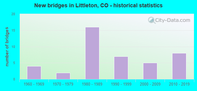
- New bridges - historical statistics
- 41960-1969
- 21970-1979
- 161980-1989
- 71990-1999
- 52000-2009
- 82010-2019


- Bridge Condition - Deck
- 3.2%Very good
- 51.6%Good
- 29.0%Satisfactory
- 16.1%Fair

- Bridge Condition - Superstructure
- 58.1%Good
- 29.0%Satisfactory
- 9.7%Fair
- 3.2%Serious

- Bridge Condition - Substructure
- 3.2%Very good
- 54.8%Good
- 32.3%Satisfactory
- 6.5%Fair
- 3.2%Poor

- Bridge Condition - Channel
- 52.0%Very good
- 36.0%Good
- 12.0%Satisfactory

- Bridge Condition - Culverts
- 20.0%Good
- 60.0%Satisfactory
- 20.0%Fair
Find on map >> Show street view
Structure Number: F-16-IE, Location: 0.4 MI W OF JCT US 85 (Lat: 39.566331, Lng: -105.041161), Route carried "on" structure: State highway 470A, Year Built: 2018, Status: Open, Structure Length: 6.55m (21.49ft), Average Daily Traffic: 36,500 (year 2020), Truck Traffic: 3%, Average Future Daily Traffic: 47,815 (year 2040), Design Load: HL 93, Features Intersected: SOUTH PLATTE RIVER, Facility Carried by Structure: SH 470 ML EBND
Minimum Vertical Clearance: 30+ m (98+ ft), Kilometerpoint: 26.762, Lanes on structure: 4, Base Highway Network: Yes, Owner: State Highway Agency, Approaching Roadway Width: 22.6m (74.1ft), Skew: 13 degrees, Material/Design: Prestressed concrete continuous, Design/Construction: Stringer/Multi-beam, Number Of Spans In Main Unit: 2, Length of Maximum Span: 30.8m (101.0ft), Curb-To-Curb Width: 22.6m (74.1ft), Out-to-Out Width: 23.5m (77.1ft)
Condition: Deck: Good, Superstructure: Good, Substructure: Very good, Channel: Very good, Operating Rating: 48.6 metric tons, Method Used To Determine Operating Rating: Load and Resistance Factor Rating (LRFR) rating reported by rating factor(RF) method using HL-93 loadings, Inventory Rating: 35.6 metric tons, Method Used To Determine Inventory Rating: Load and Resistance Factor Rating (LRFR) rating reported by rating factor(RF) method using HL-93 loadings, Structural Evaluation: Better than present minimum criteria, Deck Geometry: Superior to present desirable criteria, Waterway Adequacy: Equal to present desirable criteria, Approach Roadway Alignment: Equal to present desirable criteria, Designated Inspection Frequency: Every 24 months, Inspection Date: April 2021, Deck Structure Type: Concrete Precast Panels, Wearing Surface/Protective System: Wearing Surface: Bituminous, Membrane: Preformed Fabric, Deck Protection: Epoxy Coated Reinforcing
Find on map >> Show street view
Structure Number: F-16-IF, Location: 0.4 MI W.OF US 85 (Lat: 39.566258, Lng: -105.041436), Route carried "on" structure: State highway 470A, Year Built: 2019, Status: Open, Structure Length: 6.55m (21.49ft), Average Daily Traffic: 36,500 (year 2020), Truck Traffic: 3%, Average Future Daily Traffic: 47,815 (year 2040), Design Load: HL 93, Features Intersected: SOUTH PLATTE RIVER, Facility Carried by Structure: SH 470 ML WBND
Minimum Vertical Clearance: 30+ m (98+ ft), Kilometerpoint: 26.757, Lanes on structure: 4, Base Highway Network: Yes, Owner: State Highway Agency, Approaching Roadway Width: 22.6m (74.1ft), Skew: 13 degrees, Material/Design: Prestressed concrete continuous, Design/Construction: Stringer/Multi-beam, Number Of Spans In Main Unit: 2, Length of Maximum Span: 30.8m (101.0ft), Curb-To-Curb Width: 22.6m (74.1ft), Out-to-Out Width: 23.5m (77.1ft)
Condition: Deck: Good, Superstructure: Good, Substructure: Good, Operating Rating: 48.6 metric tons, Method Used To Determine Operating Rating: Load and Resistance Factor Rating (LRFR) rating reported by rating factor(RF) method using HL-93 loadings, Inventory Rating: 35.6 metric tons, Method Used To Determine Inventory Rating: Load and Resistance Factor Rating (LRFR) rating reported by rating factor(RF) method using HL-93 loadings, Structural Evaluation: Better than present minimum criteria, Deck Geometry: Superior to present desirable criteria, Approach Roadway Alignment: Equal to present desirable criteria, Designated Inspection Frequency: Every 24 months, Inspection Date: April 2021, Deck Structure Type: Concrete Precast Panels, Wearing Surface/Protective System: Wearing Surface: Bituminous, Membrane: Preformed Fabric, Deck Protection: Epoxy Coated Reinforcing
Find on map >> Show street view
Structure Number: F-16-JM, Location: 0.25 MI W OF SANTA FE (Lat: 39.613136, Lng: -105.025169), Route carried "on" structure: City street , Year Built: 1979, Status: Open, Structure Length: 6.78m (22.24ft), Average Daily Traffic: 15,802 (year 2021), Truck Traffic: 3%, Average Future Daily Traffic: 19,279 (year 2041), Design Load: HS 20, Features Intersected: SOUTH PLATTE RIVER, Facility Carried by Structure: BOWLES AVE
Minimum Vertical Clearance: 30+ m (98+ ft), Kilometerpoint: 2.530, Lanes on structure: 4, Base Highway Network: Yes, Owner: City or Municipal Highway Agency, Approaching Roadway Width: 15.9m (52.2ft), Skew: 1 degrees, Material/Design: Prestressed concrete continuous, Design/Construction: Stringer/Multi-beam, Number Of Spans In Main Unit: 2, Length of Maximum Span: 32.6m (107.0ft), Curb or Sidewalk Widths: Left: 1.5m (4.9ft), Right: 2.3m (7.5ft), Curb-To-Curb Width: 15.9m (52.2ft), Out-to-Out Width: 20.6m (67.6ft)
Condition: Deck: Satisfactory, Superstructure: Good, Substructure: Satisfactory, Channel: Satisfactory, Operating Rating: 59.1 metric tons, Method Used To Determine Operating Rating: Load Factor (LF), Inventory Rating: 25.0 metric tons, Method Used To Determine Inventory Rating: Load Factor (LF), Structural Evaluation: Equal to present minimum criteria, Deck Geometry: Meets minimum limits, Waterway Adequacy: Equal to present desirable criteria, Approach Roadway Alignment: Equal to present desirable criteria, Designated Inspection Frequency: Every 24 months, Inspection Date: September 2021, Deck Structure Type: Concrete Cast-file-Place, Wearing Surface/Protective System: Wearing Surface: Bituminous
Find on map >> Show street view
Structure Number: F-16-JV, Location: LITTLETON (Lat: 39.623911, Lng: -105.010806), Route carried "on" structure: City street , Year Built: 1980, Status: Open, Structure Length: 5.26m (17.26ft), Average Daily Traffic: 2,166 (year 2021), Truck Traffic: 4%, Average Future Daily Traffic: 2,643 (year 2041), Design Load: HS 20+Mod, Features Intersected: US 88 ML, Facility Carried by Structure: RIO GRANDE ST
Minimum Vertical Clearance: 30+ m (98+ ft), Kilometerpoint: 1.181, Lanes on structure: 2, Lanes under structure: 6, Owner: State Highway Agency, Approaching Roadway Width: 13.4m (44.0ft), Skew: 1 degrees, Material/Design: Steel continuous, Design/Construction: Stringer/Multi-beam, Number Of Spans In Main Unit: 2, Length of Maximum Span: 25.9m (85.0ft), Curb or Sidewalk Widths: Left: 1.8m (5.9ft), Right: 0.0m, Curb-To-Curb Width: 11.0m (36.1ft), Out-to-Out Width: 13.6m (44.6ft)
Condition: Deck: Good, Superstructure: Good, Substructure: Good, Operating Rating: 69.4 metric tons, Method Used To Determine Operating Rating: Load Factor (LF), Inventory Rating: 41.5 metric tons, Method Used To Determine Inventory Rating: Load Factor (LF), Structural Evaluation: Better than present minimum criteria, Deck Geometry: Somewhat better than minimum adequacy, Underclear: High priority of corrective action, Approach Roadway Alignment: Equal to present desirable criteria, Designated Inspection Frequency: Every 24 months, Inspection Date: June 2020, Deck Structure Type: Concrete Cast-file-Place, Wearing Surface/Protective System: Wearing Surface: Bituminous, Membrane: Preformed Fabric
Find on map >> Show street view
Structure Number: F-16-KL, Location: .3 M EAST OF JCT US 85 (Lat: 39.563822, Lng: -105.026819), Route carried "on" structure: State highway 470A, Year Built: 1984, Status: Open, Structure Length: 3.06m (10.04ft), Average Daily Traffic: 40,500 (year 2020), Truck Traffic: 2%, Average Future Daily Traffic: 53,460 (year 2040), Design Load: HL 93, Features Intersected: S. ERICKSON BLVD., Facility Carried by Structure: SH 470 ML EBND
Minimum Vertical Clearance: 30+ m (98+ ft), Kilometerpoint: 28.059, Lanes on structure: 3, Lanes under structure: 4, Base Highway Network: Yes, Owner: State Highway Agency, Approaching Roadway Width: 11.6m (38.1ft), Skew: 10 degrees, Material/Design: Prestressed concrete, Design/Construction: Stringer/Multi-beam, Number Of Spans In Main Unit: 1, Length of Maximum Span: 30.6m (100.4ft), Curb-To-Curb Width: 18.9m (62.0ft), Out-to-Out Width: 19.8m (65.0ft)
Condition: Deck: Good, Superstructure: Good, Substructure: Good, Operating Rating: 55.1 metric tons, Method Used To Determine Operating Rating: Load and Resistance Factor Rating (LRFR) rating reported by rating factor(RF) method using HL-93 loadings, Inventory Rating: 35.6 metric tons, Method Used To Determine Inventory Rating: Load and Resistance Factor Rating (LRFR) rating reported by rating factor(RF) method using HL-93 loadings, Structural Evaluation: Better than present minimum criteria, Deck Geometry: Superior to present desirable criteria, Underclear: Somewhat better than minimum adequacy, Approach Roadway Alignment: Equal to present desirable criteria, Designated Inspection Frequency: Every 24 months, Inspection Date: March 2021, Deck Structure Type: Concrete Cast-file-Place, Wearing Surface/Protective System: Wearing Surface: Bituminous, Membrane: Preformed Fabric, Deck Protection: Epoxy Coated Reinforcing
Find on map >> Show street view
Structure Number: F-16-KM, Location: .3 MI E. OF JCT SH 85 (Lat: 39.564064, Lng: -105.026819), Route carried "on" structure: ServiceState highway 470A, Year Built: 1984, Status: Open, Structure Length: 3.08m (10.10ft), Average Daily Traffic: 40,500 (year 2020), Truck Traffic: 2%, Average Future Daily Traffic: 53,460 (year 2040), Design Load: HS 20+Mod, Features Intersected: S. ERICKSON BLVD., Facility Carried by Structure: SH 470 ML WBND
Minimum Vertical Clearance: 30+ m (98+ ft), Kilometerpoint: 28.057, Lanes on structure: 4, Lanes under structure: 4, Base Highway Network: Yes, Owner: State Highway Agency, Approaching Roadway Width: 14.0m (45.9ft), Skew: 10 degrees, Material/Design: Prestressed concrete, Design/Construction: Stringer/Multi-beam, Number Of Spans In Main Unit: 1, Length of Maximum Span: 30.0m (98.4ft), Curb-To-Curb Width: 28.5m (93.5ft), Out-to-Out Width: 28.5m (93.5ft)
Condition: Deck: Good, Superstructure: Good, Substructure: Good, Operating Rating: 54.5 metric tons, Method Used To Determine Operating Rating: Load Factor (LF), Inventory Rating: 31.8 metric tons, Method Used To Determine Inventory Rating: Load Factor (LF), Structural Evaluation: Better than present minimum criteria, Deck Geometry: Superior to present desirable criteria, Underclear: Better than present minimum criteria, Approach Roadway Alignment: Equal to present desirable criteria, Designated Inspection Frequency: Every 24 months, Inspection Date: March 2021, Deck Structure Type: Concrete Cast-file-Place, Wearing Surface/Protective System: Wearing Surface: Bituminous, Membrane: Preformed Fabric, Deck Protection: Epoxy Coated Reinforcing
Find on map >> Show street view
Structure Number: F-16-KO, Location: IN LITTLETON (Lat: 39.573139, Lng: -105.028961), Route carried "on" structure: US 85B, Year Built: 2004, Status: Open, Structure Length: 3.43m (11.25ft), Average Daily Traffic: 22,000 (year 2020), Truck Traffic: 9%, Average Future Daily Traffic: 27,940 (year 2040), Design Load: HL 93, Features Intersected: DAD CLARK GULCH, Facility Carried by Structure: US 85 ML SBND
Minimum Vertical Clearance: 30+ m (98+ ft), Kilometerpoint: 26.292, Lanes on structure: 3, Base Highway Network: Yes, Owner: State Highway Agency, Approaching Roadway Width: 12.2m (40.0ft), Skew: 2 degrees, Material/Design: Prestressed concrete, Design/Construction: Stringer/Multi-beam, Number Of Spans In Main Unit: 1, Length of Maximum Span: 33.5m (109.9ft), Curb-To-Curb Width: 12.2m (40.0ft), Out-to-Out Width: 13.1m (43.0ft)
Condition: Deck: Good, Superstructure: Good, Substructure: Good, Channel: Good, Operating Rating: 51.8 metric tons, Method Used To Determine Operating Rating: Load and Resistance Factor Rating (LRFR) rating reported by rating factor(RF) method using HL-93 loadings, Inventory Rating: 32.4 metric tons, Method Used To Determine Inventory Rating: Load and Resistance Factor Rating (LRFR) rating reported by rating factor(RF) method using HL-93 loadings, Structural Evaluation: Better than present minimum criteria, Deck Geometry: High priority of replacement, Waterway Adequacy: Equal to present desirable criteria, Approach Roadway Alignment: Equal to present desirable criteria, Designated Inspection Frequency: Every 24 months, Inspection Date: August 2020, Deck Structure Type: Concrete Cast-file-Place, Wearing Surface/Protective System: Wearing Surface: Bituminous, Membrane: Built-up, Deck Protection: Epoxy Coated Reinforcing
Find on map >> Show street view
Structure Number: F-16-KP, Location: .5 M E OF JCT US 85 (Lat: 39.563561, Lng: -105.022542), Route carried "on" structure: State highway 470A, Year Built: 1984, Status: Open, Structure Length: 0.88m (2.89ft), Average Daily Traffic: 81,000 (year 2020), Truck Traffic: 2%, Average Future Daily Traffic: 106,920 (year 2040), Design Load: HS 20+Mod, Features Intersected: HIGHLINE CANAL, Facility Carried by Structure: SH 470 ML
Minimum Vertical Clearance: 30+ m (98+ ft), Kilometerpoint: 28.432, Lanes on structure: 4, Base Highway Network: Yes, Owner: State Highway Agency, Approaching Roadway Width: 23.2m (76.1ft), Skew: 24 degrees, Material/Design: Concrete, Design/Construction: Culvert, Number Of Spans In Main Unit: 1, Length of Maximum Span: 8.8m (28.9ft), Out-to-Out Width: 76.8m (252.0ft)
Condition: Channel: Very good, Culverts: Good, Operating Rating: 89.8 metric tons, Method Used To Determine Operating Rating: Field evaluation and documented engineering judgment, Inventory Rating: 89.8 metric tons, Method Used To Determine Inventory Rating: Field evaluation and documented engineering judgment, Structural Evaluation: Better than present minimum criteria, Waterway Adequacy: Equal to present desirable criteria, Approach Roadway Alignment: Equal to present desirable criteria, Length Of Structure Improvement: 0.89m (2.92ft), Designated Inspection Frequency: Every 48 months, Inspection Date: January 2019, Bridge Improvement Cost: $263,000, Roadway Improvement Cost: $26,000, Total Project Cost: $395,000
Find on map >> Show street view
Structure Number: F-16-MJ, Location: BELLEVIEW & SANTA FE (Lat: 39.623644, Lng: -105.013444), Route carried "on" structure: US 85B, Year Built: 1998, Status: Open, Structure Length: 14.97m (49.11ft), Average Daily Traffic: 54,000 (year 2020), Truck Traffic: 9%, Average Future Daily Traffic: 68,580 (year 2040), Design Load: HS 20, Features Intersected: SH 88-BELLEVIEW AVE, Facility Carried by Structure: US 85
Minimum Vertical Clearance: 30+ m (98+ ft), Kilometerpoint: 32.182, Lanes on structure: 6, Lanes under structure: 6, Base Highway Network: Yes, Owner: State Highway Agency, Approaching Roadway Width: 34.1m (111.9ft), Skew: 33 degrees, Material/Design: Prestressed concrete continuous, Design/Construction: Box Beam or Girders - Multiple, Number Of Spans In Main Unit: 3, Length of Maximum Span: 77.1m (253.0ft), Curb-To-Curb Width: 33.6m (110.2ft), Out-to-Out Width: 35.0m (114.8ft)
Condition: Deck: Satisfactory, Superstructure: Satisfactory, Substructure: Satisfactory, Operating Rating: 95.3 metric tons, Method Used To Determine Operating Rating: Load Factor (LF), Inventory Rating: 57.0 metric tons, Method Used To Determine Inventory Rating: Load Factor (LF), Structural Evaluation: Equal to present minimum criteria, Deck Geometry: Superior to present desirable criteria, Underclear: Superior to present desirable criteria, Approach Roadway Alignment: Equal to present desirable criteria, Designated Inspection Frequency: Every 24 months, Inspection Date: May 2020, Deck Structure Type: Concrete Cast-file-Place, Wearing Surface/Protective System: Wearing Surface: Integral Concrete, Deck Protection: Epoxy Coated Reinforcing
Find on map >> Show street view
Structure Number: F-16-OU, Location: IN LITTLETON (Lat: 39.624100, Lng: -105.018300), Route carried "on" structure: State highway 88A, Year Built: 1988, Status: Open, Structure Length: 5.97m (19.59ft), Average Daily Traffic: 27,000 (year 2020), Truck Traffic: 3%, Average Future Daily Traffic: 29,970 (year 2040), Design Load: HS 20, Features Intersected: SOUTH PLATTE RIVER, Facility Carried by Structure: SH 88 ML/Belleview
Minimum Vertical Clearance: 30+ m (98+ ft), Kilometerpoint: 13.527, Lanes on structure: 6, Base Highway Network: Yes, Owner: State Highway Agency, Approaching Roadway Width: 23.2m (76.1ft), Skew: 22 degrees, Material/Design: Prestressed concrete continuous, Design/Construction: Box Beam or Girders - Multiple, Number Of Spans In Main Unit: 2, Length of Maximum Span: 29.6m (97.1ft), Curb or Sidewalk Widths: Left: 2.6m (8.5ft), Right: 1.7m (5.6ft), Curb-To-Curb Width: 23.2m (76.1ft), Out-to-Out Width: 33.1m (108.6ft)
Condition: Deck: Good, Superstructure: Satisfactory, Substructure: Good, Channel: Very good, Operating Rating: 56.2 metric tons, Method Used To Determine Operating Rating: Load Factor (LF), Inventory Rating: 28.8 metric tons, Method Used To Determine Inventory Rating: Load Factor (LF), Structural Evaluation: Equal to present minimum criteria, Deck Geometry: Meets minimum limits, Waterway Adequacy: Equal to present desirable criteria, Approach Roadway Alignment: Equal to present desirable criteria, Designated Inspection Frequency: Every 24 months, Inspection Date: May 2020, Deck Structure Type: Concrete Cast-file-Place, Wearing Surface/Protective System: Wearing Surface: Bituminous, Membrane: Preformed Fabric
Find on map >> Show street view
Structure Number: F-16-UA, Location: US 285 OVER N. ACCESS RD (Lat: 39.546814, Lng: -105.271900), Route carried "on" structure: ServiceUS 285D, Year Built: 2002, Status: Open, Structure Length: 1.52m (4.99ft), Average Daily Traffic: 26,000 (year 2020), Truck Traffic: 4%, Average Future Daily Traffic: 32,240 (year 2040), Design Load: HS 25 or greater, Features Intersected: NORTH ACCESS ROAD, Facility Carried by Structure: US 285 ML
Minimum Vertical Clearance: 30+ m (98+ ft), Kilometerpoint: 123.969, Lanes on structure: 6, Lanes under structure: 2, Base Highway Network: Yes, Owner: State Highway Agency, Approaching Roadway Width: 28.0m (91.9ft), Skew: 20 degrees, Material/Design: Prestressed concrete, Design/Construction: Box Beam or Girders - Multiple, Number Of Spans In Main Unit: 1, Length of Maximum Span: 14.6m (47.9ft), Curb-To-Curb Width: 34.7m (113.8ft), Out-to-Out Width: 35.5m (116.5ft)
Condition: Deck: Good, Superstructure: Good, Substructure: Good, Operating Rating: 71.1 metric tons, Method Used To Determine Operating Rating: Load Factor (LF), Inventory Rating: 42.6 metric tons, Method Used To Determine Inventory Rating: Load Factor (LF), Structural Evaluation: Better than present minimum criteria, Deck Geometry: Superior to present desirable criteria, Underclear: Meets minimum limits, Approach Roadway Alignment: Equal to present desirable criteria, Designated Inspection Frequency: Every 24 months, Inspection Date: August 2021, Deck Structure Type: Concrete Cast-file-Place, Wearing Surface/Protective System: Wearing Surface: Bituminous, Membrane: Other, Deck Protection: Epoxy Coated Reinforcing
Find on map >> Show street view
Structure Number: F-16-UB, Location: NEAR BELLEVIEW (Lat: 39.619122, Lng: -105.017347), Route carried "on" structure: US 85B, Year Built: 1999, Status: Open, Structure Length: 0.64m (2.10ft), Average Daily Traffic: 54,000 (year 2020), Truck Traffic: 9%, Average Future Daily Traffic: 68,580 (year 2040), Design Load: HS 20, Features Intersected: SLAUGHTER HOUSE GULCH, Facility Carried by Structure: US 85ML
Minimum Vertical Clearance: 30+ m (98+ ft), Kilometerpoint: 31.577, Lanes on structure: 9, Base Highway Network: Yes, Owner: State Highway Agency, Approaching Roadway Width: 36.9m (121.1ft), Material/Design: Concrete, Design/Construction: Culvert, Number Of Spans In Main Unit: 2, Length of Maximum Span: 3.0m (9.8ft), Out-to-Out Width: 73.2m (240.2ft)
Condition: Channel: Very good, Culverts: Satisfactory, Structural Evaluation: Equal to present minimum criteria, Waterway Adequacy: Equal to present desirable criteria, Approach Roadway Alignment: Equal to present desirable criteria, Designated Inspection Frequency: Every 24 months, Inspection Date: September 2020
Find on map >> Show street view
Structure Number: F-16-WI, Location: HAMPDEN/WADSWORTH (Lat: 39.652717, Lng: -105.081114), Route carried "on" structure: US 285D, Year Built: 2012, Status: Open, Structure Length: 4.51m (14.80ft), Average Daily Traffic: 24,500 (year 2020), Truck Traffic: 2%, Average Future Daily Traffic: 30,380 (year 2040), Features Intersected: SH 121 ML, Facility Carried by Structure: US 285 ML NBND
Minimum Vertical Clearance: 30+ m (98+ ft), Kilometerpoint: 149.733, Lanes on structure: 2, Lanes under structure: 9, Base Highway Network: Yes, Owner: State Highway Agency, Approaching Roadway Width: 11.6m (38.1ft), Material/Design: Prestressed concrete, Design/Construction: Stringer/Multi-beam, Number Of Spans In Main Unit: 1, Length of Maximum Span: 43.3m (142.1ft), Curb-To-Curb Width: 18.3m (60.0ft), Out-to-Out Width: 19.2m (63.0ft)
Condition: Deck: Very good, Superstructure: Good, Substructure: Good, Operating Rating: 78.7 metric tons, Method Used To Determine Operating Rating: Load Factor (LF), Inventory Rating: 48.1 metric tons, Method Used To Determine Inventory Rating: Load Factor (LF), Structural Evaluation: Better than present minimum criteria, Deck Geometry: Superior to present desirable criteria, Underclear: Equal to present minimum criteria, Approach Roadway Alignment: Equal to present desirable criteria, Length Of Structure Improvement: 5.15m (16.90ft), Designated Inspection Frequency: Every 24 months, Inspection Date: May 2020, Bridge Improvement Cost: $910,000, Roadway Improvement Cost: $91,000, Total Project Cost: $1,366,000, Deck Structure Type: Concrete Cast-file-Place, Wearing Surface/Protective System: Wearing Surface: Bituminous, Membrane: Built-up, Deck Protection: Epoxy Coated Reinforcing
Find on map >> Show street view
Structure Number: F-16-WY, Location: LITTLETON (Lat: 39.563617, Lng: -105.026906), Route carried "on" structure: Ramp State highway 470A, Year Built: 2012, Status: Open, Structure Length: 3.90m (12.80ft), Average Daily Traffic: 81,000 (year 2020), Truck Traffic: 2%, Average Future Daily Traffic: 106,920 (year 2040), Features Intersected: ERICKSON BLVD., Facility Carried by Structure: US 85 TO C470 RAMP
Minimum Vertical Clearance: 30+ m (98+ ft), Kilometerpoint: 0.584, Lanes on structure: 2, Lanes under structure: 2, Base Highway Network: Yes, Owner: State Highway Agency, Approaching Roadway Width: 11.0m (36.1ft), Material/Design: Prestressed concrete, Design/Construction: Girder and Floorbeam System, Number Of Spans In Main Unit: 1, Length of Maximum Span: 38.1m (125.0ft), Curb-To-Curb Width: 11.0m (36.1ft), Out-to-Out Width: 11.9m (39.0ft)
Condition: Deck: Good, Superstructure: Good, Substructure: Good, Operating Rating: 63.0 metric tons, Method Used To Determine Operating Rating: Load Factor (LF), Inventory Rating: 32.1 metric tons, Method Used To Determine Inventory Rating: Load Factor (LF), Structural Evaluation: Better than present minimum criteria, Deck Geometry: Better than present minimum criteria, Underclear: Somewhat better than minimum adequacy, Approach Roadway Alignment: Equal to present desirable criteria, Designated Inspection Frequency: Every 24 months, Inspection Date: March 2021, Deck Structure Type: Concrete Precast Panels, Wearing Surface/Protective System: Wearing Surface: Epoxy Overlay, Membrane: Built-up, Deck Protection: Galvanized Reinforcing
Find on map >> Show street view
Structure Number: LTNB.210-04.25, Location: .4 MI W OF BROADWAY (Lat: 39.621094, Lng: -104.992603), Route carried "on" structure: City street , Year Built: 1979, Status: Open, Structure Length: 1.26m (4.13ft), Average Daily Traffic: 3,612 (year 2021), Truck Traffic: 2%, Average Future Daily Traffic: 4,407 (year 2041), Features Intersected: BIG DRY CREEK, Facility Carried by Structure: LEHOW AVE
Minimum Vertical Clearance: 30+ m (98+ ft), Kilometerpoint: 0.003, Lanes on structure: 2, Owner: City or Municipal Highway Agency, Approaching Roadway Width: 11.6m (38.1ft), Skew: 1 degrees, Material/Design: Concrete, Design/Construction: Culvert, Number Of Spans In Main Unit: 2, Length of Maximum Span: 6.2m (20.3ft), Curb or Sidewalk Widths: Left: 2.1m (6.9ft), Right: 2.1m (6.9ft), Curb-To-Curb Width: 15.8m (51.8ft), Out-to-Out Width: 16.5m (54.1ft)
Condition: Channel: Good, Culverts: Satisfactory, Operating Rating: 36.3 metric tons, Method Used To Determine Operating Rating: Field evaluation and documented engineering judgment, Inventory Rating: 32.7 metric tons, Method Used To Determine Inventory Rating: Field evaluation and documented engineering judgment, Structural Evaluation: Equal to present minimum criteria, Deck Geometry: Superior to present desirable criteria, Waterway Adequacy: Equal to present desirable criteria, Approach Roadway Alignment: Equal to present desirable criteria, Designated Inspection Frequency: Every 24 months, Inspection Date: September 2021
Find on map >> Show street view
Structure Number: LTNB.232-03., Location: 0.1 MI W OF SANTA FE (Lat: 39.620986, Lng: -105.017358), Route carried "on" structure: City street , Year Built: 1985, Status: Open, Structure Length: 4.28m (14.04ft), Average Daily Traffic: 7,025 (year 2021), Truck Traffic: 2%, Average Future Daily Traffic: 8,571 (year 2041), Design Load: HS 20, Features Intersected: SOUTH PLATTE RIVER, Facility Carried by Structure: SOUTH PRINCE ST
Minimum Vertical Clearance: 30+ m (98+ ft), Kilometerpoint: 4.794, Lanes on structure: 5, Owner: City or Municipal Highway Agency, Approaching Roadway Width: 22.6m (74.1ft), Skew: 30 degrees, Material/Design: Steel continuous, Design/Construction: Stringer/Multi-beam, Number Of Spans In Main Unit: 2, Length of Maximum Span: 20.5m (67.3ft), Curb or Sidewalk Widths: Left: 2.6m (8.5ft), Right: 2.5m (8.2ft), Curb-To-Curb Width: 22.6m (74.1ft), Out-to-Out Width: 30.1m (98.8ft)
Condition: Deck: Good, Superstructure: Good, Substructure: Good, Channel: Very good, Operating Rating: 50.3 metric tons, Method Used To Determine Operating Rating: Load Factor (LF), Inventory Rating: 30.1 metric tons, Method Used To Determine Inventory Rating: Load Factor (LF), Structural Evaluation: Better than present minimum criteria, Deck Geometry: Equal to present minimum criteria, Waterway Adequacy: Equal to present desirable criteria, Approach Roadway Alignment: Equal to present desirable criteria, Designated Inspection Frequency: Every 48 months, Inspection Date: September 2021, Deck Structure Type: Concrete Cast-file-Place, Wearing Surface/Protective System: Wearing Surface: Bituminous
Find on map >> Show street view
Structure Number: LTNB.290-03.015, Location: JUST S OF CRESTLINE AVE (Lat: 39.619125, Lng: -105.016142), Route carried "on" structure: City street , Year Built: 1998, Status: Open, Structure Length: 0.63m (2.07ft), Average Daily Traffic: 6,372 (year 2021), Truck Traffic: 2%, Average Future Daily Traffic: 7,774 (year 2041), Design Load: HS 25 or greater, Features Intersected: SLAUGHTERHOUSE GULCH, Facility Carried by Structure: PRINCE STREET
Minimum Vertical Clearance: 30+ m (98+ ft), Kilometerpoint: 4.497, Lanes on structure: 3, Owner: City or Municipal Highway Agency, Approaching Roadway Width: 14.6m (47.9ft), Material/Design: Concrete, Design/Construction: Culvert, Number Of Spans In Main Unit: 2, Length of Maximum Span: 3.0m (9.8ft), Curb or Sidewalk Widths: Left: 1.7m (5.6ft), Right: 1.4m (4.6ft), Out-to-Out Width: 30.2m (99.1ft)
Condition: Channel: Very good, Culverts: Satisfactory, Operating Rating: 36.3 metric tons, Method Used To Determine Operating Rating: Field evaluation and documented engineering judgment, Inventory Rating: 32.7 metric tons, Method Used To Determine Inventory Rating: Field evaluation and documented engineering judgment, Structural Evaluation: Equal to present minimum criteria, Waterway Adequacy: Equal to present desirable criteria, Approach Roadway Alignment: Equal to present desirable criteria, Designated Inspection Frequency: Every 24 months, Inspection Date: September 2021
Find on map >> Show street view
Structure Number: LTNB.750-03.175, Location: JUST E OF RIO GRANDE ST (Lat: 39.613553, Lng: -105.013894), Route carried "on" structure: City street , Year Built: 1985, Status: Open, Structure Length: 3.36m (11.02ft), Average Daily Traffic: 12,746 (year 2021), Truck Traffic: 2%, Average Future Daily Traffic: 15,550 (year 2041), Design Load: HS 20, Features Intersected: RAILROAD AND LRT, Facility Carried by Structure: MAIN STREET
Minimum Vertical Clearance: 30+ m (98+ ft), Kilometerpoint: 0.058, Lanes on structure: 3, Owner: City or Municipal Highway Agency, Approaching Roadway Width: 12.2m (40.0ft), Material/Design: Prestressed concrete, Design/Construction: Box Beam or Girders - Multiple, Number Of Spans In Main Unit: 1, Length of Maximum Span: 32.0m (105.0ft), Curb or Sidewalk Widths: Left: 3.0m (9.8ft), Right: 0.0m, Curb-To-Curb Width: 12.2m (40.0ft), Out-to-Out Width: 16.0m (52.5ft)
Condition: Deck: Good, Superstructure: Good, Substructure: Good, Operating Rating: 54.2 metric tons, Method Used To Determine Operating Rating: Load Factor (LF), Inventory Rating: 32.5 metric tons, Method Used To Determine Inventory Rating: Load Factor (LF), Structural Evaluation: Better than present minimum criteria, Deck Geometry: Meets minimum limits, Underclear: Meets minimum limits, Approach Roadway Alignment: Equal to present desirable criteria, Designated Inspection Frequency: Every 24 months, Inspection Date: September 2021, Deck Structure Type: Concrete Cast-file-Place, Wearing Surface/Protective System: Wearing Surface: Bituminous, Membrane: Built-up, Deck Protection: Epoxy Coated Reinforcing
Find on map >> Show street view
Structure Number: LTNB.754-4.904A, Location: .3 MI E OF BROADWAY (Lat: 39.613228, Lng: -104.980439), Route carried "on" structure: City street , Year Built: 1986, Status: Open, Structure Length: 1.20m (3.94ft), Average Daily Traffic: 1,656 (year 2021), Truck Traffic: 4%, Average Future Daily Traffic: 2,020 (year 2041), Design Load: HS 20, Features Intersected: BIG DRY CREEK, Facility Carried by Structure: LITTLETON BLVD
Minimum Vertical Clearance: 30+ m (98+ ft), Kilometerpoint: 0.003, Lanes on structure: 2, Owner: City or Municipal Highway Agency, Approaching Roadway Width: 11.0m (36.1ft), Skew: 3 degrees, Material/Design: Concrete, Design/Construction: Slab, Number Of Spans In Main Unit: 1, Length of Maximum Span: 11.2m (36.7ft), Curb or Sidewalk Widths: Left: 1.9m (6.2ft), Right: 0.0m, Curb-To-Curb Width: 8.5m (27.9ft), Out-to-Out Width: 11.2m (36.7ft)
Condition: Deck: Fair, Superstructure: Satisfactory, Substructure: Satisfactory, Channel: Good, Operating Rating: 60.4 metric tons, Method Used To Determine Operating Rating: Load Factor (LF), Inventory Rating: 36.3 metric tons, Method Used To Determine Inventory Rating: Load Factor (LF), Structural Evaluation: Equal to present minimum criteria, Deck Geometry: Somewhat better than minimum adequacy, Waterway Adequacy: Equal to present desirable criteria, Approach Roadway Alignment: Equal to present desirable criteria, Designated Inspection Frequency: Every 24 months, Inspection Date: September 2021, Deck Structure Type: Concrete Cast-file-Place, Wearing Surface/Protective System: Wearing Surface: Bituminous
Find on map >> Show street view
Structure Number: LTNB.775-03.168, Location: JUST E OF RIO GRANDE ST (Lat: 39.612944, Lng: -105.014214), Route carried "on" structure: City street , Year Built: 1985, Status: Open, Structure Length: 5.33m (17.49ft), Average Daily Traffic: 14,096 (year 2021), Truck Traffic: 5%, Average Future Daily Traffic: 17,197 (year 2041), Design Load: HS 20, Features Intersected: RAILROAD AND LRT, Facility Carried by Structure: ALAMO AVENUE
Minimum Vertical Clearance: 30+ m (98+ ft), Kilometerpoint: 0.557, Lanes on structure: 2, Owner: City or Municipal Highway Agency, Approaching Roadway Width: 8.5m (27.9ft), Skew: 5 degrees, Material/Design: Prestressed concrete continuous, Design/Construction: Box Beam or Girders - Multiple, Number Of Spans In Main Unit: 2, Length of Maximum Span: 27.4m (89.9ft), Curb or Sidewalk Widths: Left: 0.0m, Right: 1.8m (5.9ft), Curb-To-Curb Width: 8.5m (27.9ft), Out-to-Out Width: 11.1m (36.4ft)
Condition: Deck: Good, Superstructure: Good, Substructure: Good, Operating Rating: 56.2 metric tons, Method Used To Determine Operating Rating: Load Factor (LF), Inventory Rating: 33.7 metric tons, Method Used To Determine Inventory Rating: Load Factor (LF), Structural Evaluation: Better than present minimum criteria, Deck Geometry: High priority of corrective action, Underclear: High priority of corrective action, Approach Roadway Alignment: Equal to present desirable criteria, Length Of Structure Improvement: 5.33m (17.49ft), Designated Inspection Frequency: Every 24 months, Inspection Date: September 2021, Deck Structure Type: Concrete Cast-file-Place, Wearing Surface/Protective System: Wearing Surface: Bituminous, Membrane: Built-up, Deck Protection: Epoxy Coated Reinforcing
Find on map >> Show street view
Structure Number: LTNB.824-02.848, Location: 2 BLKS S OF MAIN STREET (Lat: 39.611817, Lng: -105.019961), Route carried "on" structure: City street , Year Built: 1981, Status: Open, Structure Length: 1.08m (3.54ft), Average Daily Traffic: 2,154 (year 2021), Truck Traffic: 2%, Average Future Daily Traffic: 2,628 (year 2041), Design Load: HS 20, Features Intersected: LITTLES CREEK, Facility Carried by Structure: RAPP STREET
Minimum Vertical Clearance: 30+ m (98+ ft), Kilometerpoint: 0.139, Lanes on structure: 2, Owner: City or Municipal Highway Agency, Approaching Roadway Width: 8.8m (28.9ft), Material/Design: Concrete, Design/Construction: Slab, Number Of Spans In Main Unit: 1, Length of Maximum Span: 9.1m (29.9ft), Curb or Sidewalk Widths: Left: 2.7m (8.9ft), Right: 2.7m (8.9ft), Curb-To-Curb Width: 8.8m (28.9ft), Out-to-Out Width: 14.9m (48.9ft)
Condition: Deck: Satisfactory, Superstructure: Satisfactory, Substructure: Satisfactory, Channel: Very good, Operating Rating: 47.7 metric tons, Method Used To Determine Operating Rating: Load Factor (LF), Inventory Rating: 28.6 metric tons, Method Used To Determine Inventory Rating: Load Factor (LF), Structural Evaluation: Equal to present minimum criteria, Deck Geometry: Meets minimum limits, Waterway Adequacy: Equal to present desirable criteria, Approach Roadway Alignment: Equal to present desirable criteria, Designated Inspection Frequency: Every 24 months, Inspection Date: September 2021, Deck Structure Type: Concrete Cast-file-Place, Wearing Surface/Protective System: Wearing Surface: Bituminous, Membrane: Built-up
Find on map >> Show street view
Structure Number: LTNB.824-02.944, Location: 2 BLKS S OF MAIN STREET (Lat: 39.611808, Lng: -105.018414), Route carried "on" structure: City street , Year Built: 1981, Status: Open, Structure Length: 1.08m (3.54ft), Average Daily Traffic: 993 (year 2021), Truck Traffic: 2%, Average Future Daily Traffic: 1,211 (year 2041), Features Intersected: LITTLES CREEK, Facility Carried by Structure: CURTICE STREET
Minimum Vertical Clearance: 30+ m (98+ ft), Kilometerpoint: 0.715, Lanes on structure: 2, Owner: City or Municipal Highway Agency, Approaching Roadway Width: 11.0m (36.1ft), Material/Design: Concrete, Design/Construction: Slab, Number Of Spans In Main Unit: 1, Length of Maximum Span: 9.1m (29.9ft), Curb or Sidewalk Widths: Left: 3.4m (11.2ft), Right: 3.4m (11.2ft), Curb-To-Curb Width: 11.6m (38.1ft), Out-to-Out Width: 18.9m (62.0ft)
Condition: Deck: Good, Superstructure: Good, Substructure: Good, Channel: Very good, Operating Rating: 49.3 metric tons, Method Used To Determine Operating Rating: Load Factor (LF), Inventory Rating: 28.8 metric tons, Method Used To Determine Inventory Rating: Load Factor (LF), Structural Evaluation: Better than present minimum criteria, Deck Geometry: Better than present minimum criteria, Waterway Adequacy: Equal to present desirable criteria, Approach Roadway Alignment: Equal to present desirable criteria, Designated Inspection Frequency: Every 24 months, Inspection Date: September 2021, Deck Structure Type: Concrete Cast-file-Place, Wearing Surface/Protective System: Wearing Surface: Bituminous, Membrane: Built-up
Find on map >> Show street view
Structure Number: LTNB.826-03.059, Location: 2 BLKS S OF MAIN ST (Lat: 39.611517, Lng: -105.016219), Route carried "on" structure: City street , Year Built: 1981, Status: Open, Structure Length: 1.23m (4.04ft), Average Daily Traffic: 2,600 (year 2021), Truck Traffic: 4%, Average Future Daily Traffic: 3,172 (year 2041), Design Load: HS 20, Features Intersected: LITTLES CREEK, Facility Carried by Structure: PRINCE STREET
Minimum Vertical Clearance: 30+ m (98+ ft), Kilometerpoint: 3.693, Lanes on structure: 2, Owner: City or Municipal Highway Agency, Approaching Roadway Width: 12.2m (40.0ft), Skew: 3 degrees, Material/Design: Concrete, Design/Construction: Slab, Number Of Spans In Main Unit: 1, Length of Maximum Span: 11.7m (38.4ft), Curb or Sidewalk Widths: Left: 2.7m (8.9ft), Right: 2.7m (8.9ft), Curb-To-Curb Width: 12.2m (40.0ft), Out-to-Out Width: 18.3m (60.0ft)
Condition: Deck: Satisfactory, Superstructure: Good, Substructure: Satisfactory, Channel: Very good, Operating Rating: 50.6 metric tons, Method Used To Determine Operating Rating: Load Factor (LF), Inventory Rating: 30.3 metric tons, Method Used To Determine Inventory Rating: Load Factor (LF), Structural Evaluation: Equal to present minimum criteria, Deck Geometry: Equal to present minimum criteria, Waterway Adequacy: Equal to present desirable criteria, Approach Roadway Alignment: Equal to present desirable criteria, Designated Inspection Frequency: Every 24 months, Inspection Date: September 2021, Deck Structure Type: Concrete Cast-file-Place, Wearing Surface/Protective System: Wearing Surface: Bituminous
Find on map >> Show street view
Structure Number: LTNC.021-03.059, Location: .5 MI S OF LITTLETON BLVD (Lat: 39.609442, Lng: -105.016289), Route carried "on" structure: City street , Year Built: 1986, Status: Open, Structure Length: 8.72m (28.61ft), Average Daily Traffic: 12,671 (year 2021), Truck Traffic: 4%, Average Future Daily Traffic: 15,459 (year 2041), Design Load: HS 20, Features Intersected: RAILROAD AND LRT, Facility Carried by Structure: PRINCE STREET
Minimum Vertical Clearance: 30+ m (98+ ft), Kilometerpoint: 3.386, Lanes on structure: 3, Owner: City or Municipal Highway Agency, Approaching Roadway Width: 13.4m (44.0ft), Skew: 6 degrees, Material/Design: Prestressed concrete, Design/Construction: Box Beam or Girders - Multiple, Number Of Spans In Main Unit: 2, Length of Maximum Span: 42.4m (139.1ft), Curb or Sidewalk Widths: Left: 2.4m (7.9ft), Right: 1.5m (4.9ft), Curb-To-Curb Width: 13.4m (44.0ft), Out-to-Out Width: 18.1m (59.4ft)
Condition: Deck: Good, Superstructure: Good, Substructure: Satisfactory, Operating Rating: 51.7 metric tons, Method Used To Determine Operating Rating: Load Factor (LF), Inventory Rating: 29.0 metric tons, Method Used To Determine Inventory Rating: Load Factor (LF), Structural Evaluation: Equal to present minimum criteria, Deck Geometry: Somewhat better than minimum adequacy, Underclear: Somewhat better than minimum adequacy, Approach Roadway Alignment: Better than present minimum criteria, Designated Inspection Frequency: Every 24 months, Inspection Date: September 2021, Deck Structure Type: Concrete Cast-file-Place, Wearing Surface/Protective System: Wearing Surface: Bituminous, Membrane: Preformed Fabric
Find on map >> Show street view
Structure Number: LTNC.881-03.9, Location: AT WEST STERNE PKWY (Lat: 39.596342, Lng: -104.997719), Route carried "on" structure: City street , Year Built: 1999, Status: Open, Structure Length: 0.98m (3.22ft), Average Daily Traffic: 70 (year 2021), Truck Traffic: 5%, Average Future Daily Traffic: 85 (year 2041), Design Load: HS 20, Features Intersected: LITTLES CREEK, Facility Carried by Structure: ELATI STREET
Minimum Vertical Clearance: 7.85m (25.75ft), Kilometerpoint: 1.786, Lanes on structure: 2, Owner: City or Municipal Highway Agency, Approaching Roadway Width: 14.0m (45.9ft), Skew: 2 degrees, Material/Design: Concrete, Design/Construction: Frame, Number Of Spans In Main Unit: 1, Length of Maximum Span: 9.1m (29.9ft), Curb or Sidewalk Widths: Left: 1.6m (5.2ft), Right: 2.7m (8.9ft), Curb-To-Curb Width: 13.5m (44.3ft), Out-to-Out Width: 18.5m (60.7ft)
Condition: Deck: Satisfactory, Superstructure: Satisfactory, Substructure: Good, Channel: Good, Operating Rating: 46.0 metric tons, Method Used To Determine Operating Rating: Load Factor (LF), Inventory Rating: 27.6 metric tons, Method Used To Determine Inventory Rating: Load Factor (LF), Structural Evaluation: Equal to present minimum criteria, Deck Geometry: Superior to present desirable criteria, Waterway Adequacy: Equal to present desirable criteria, Approach Roadway Alignment: Equal to present desirable criteria, Designated Inspection Frequency: Every 24 months, Inspection Date: September 2021, Deck Structure Type: Other, Wearing Surface/Protective System: Wearing Surface: Bituminous, Deck Protection: Epoxy Coated Reinforcing
Find on map >> Show street view
Structure Number: LTNC.889-03.91, Location: AT WEST STERNE PKWY (Lat: 39.595819, Lng: -104.996583), Route carried "on" structure: City street , Year Built: 1999, Status: Open, Structure Length: 0.91m (2.99ft), Average Daily Traffic: 1,967 (year 2021), Truck Traffic: 5%, Average Future Daily Traffic: 2,399 (year 2041), Design Load: HS 20, Features Intersected: LITTLES CREEK, Facility Carried by Structure: ARAPAHOE DRIVE
Minimum Vertical Clearance: 30+ m (98+ ft), Kilometerpoint: 0.895, Lanes on structure: 2, Owner: City or Municipal Highway Agency, Approaching Roadway Width: 11.0m (36.1ft), Material/Design: Concrete, Design/Construction: Frame, Number Of Spans In Main Unit: 1, Length of Maximum Span: 8.5m (27.9ft), Curb or Sidewalk Widths: Left: 4.8m (15.7ft), Right: 4.8m (15.7ft), Curb-To-Curb Width: 11.4m (37.4ft), Out-to-Out Width: 21.6m (70.9ft)
Condition: Deck: Satisfactory, Superstructure: Satisfactory, Substructure: Good, Channel: Good, Inventory Rating: 67.4 metric tons, Method Used To Determine Inventory Rating: Load Factor (LF), Structural Evaluation: Equal to present minimum criteria, Deck Geometry: Equal to present minimum criteria, Waterway Adequacy: Equal to present desirable criteria, Approach Roadway Alignment: Equal to present desirable criteria, Designated Inspection Frequency: Every 24 months, Inspection Date: September 2021, Deck Structure Type: Other, Wearing Surface/Protective System: Wearing Surface: Bituminous, Deck Protection: Epoxy Coated Reinforcing
Find on map >> Show street view
Structure Number: LTNC.907-03.92, Location: AT WEST STERNE PKWY (Lat: 39.595203, Lng: -104.995731), Route carried "on" structure: City street , Year Built: 1999, Status: Open, Structure Length: 0.91m (2.99ft), Average Daily Traffic: 1,723 (year 2021), Truck Traffic: 1%, Average Future Daily Traffic: 2,102 (year 2041), Design Load: HS 20, Features Intersected: LITTLES CREEK, Facility Carried by Structure: DELAWARE STREET
Minimum Vertical Clearance: 30+ m (98+ ft), Kilometerpoint: 0.256, Lanes on structure: 2, Owner: City or Municipal Highway Agency, Approaching Roadway Width: 11.0m (36.1ft), Material/Design: Concrete, Design/Construction: Frame, Number Of Spans In Main Unit: 1, Length of Maximum Span: 8.5m (27.9ft), Curb or Sidewalk Widths: Left: 5.6m (18.4ft), Right: 5.0m (16.4ft), Curb-To-Curb Width: 10.5m (34.4ft), Out-to-Out Width: 21.6m (70.9ft)
Condition: Deck: Satisfactory, Superstructure: Satisfactory, Substructure: Good, Channel: Good, Inventory Rating: 80.4 metric tons, Method Used To Determine Inventory Rating: Load Factor (LF), Structural Evaluation: Equal to present minimum criteria, Deck Geometry: Equal to present minimum criteria, Waterway Adequacy: Equal to present desirable criteria, Approach Roadway Alignment: Equal to present desirable criteria, Designated Inspection Frequency: Every 24 months, Inspection Date: September 2021, Deck Structure Type: Other, Wearing Surface/Protective System: Wearing Surface: Bituminous, Deck Protection: Epoxy Coated Reinforcing
Find on map >> Show street view
Structure Number: LTNC.915-03.93, Location: AT WEST STERNE PKWY (Lat: 39.594547, Lng: -104.994875), Route carried "on" structure: City street , Year Built: 2000, Status: Open, Structure Length: 0.92m (3.02ft), Average Daily Traffic: 1,756 (year 2021), Truck Traffic: 1%, Average Future Daily Traffic: 2,142 (year 2041), Design Load: HS 20+Mod, Features Intersected: LITTLES CREEK, Facility Carried by Structure: CHEROKEE STREET
Minimum Vertical Clearance: 30+ m (98+ ft), Kilometerpoint: 0.686, Lanes on structure: 2, Owner: City or Municipal Highway Agency, Approaching Roadway Width: 11.0m (36.1ft), Material/Design: Concrete, Design/Construction: Frame, Number Of Spans In Main Unit: 1, Length of Maximum Span: 8.6m (28.2ft), Curb or Sidewalk Widths: Left: 4.8m (15.7ft), Right: 4.8m (15.7ft), Curb-To-Curb Width: 11.4m (37.4ft), Out-to-Out Width: 21.5m (70.5ft)
Condition: Deck: Satisfactory, Superstructure: Satisfactory, Substructure: Satisfactory, Channel: Very good, Operating Rating: 39.8 metric tons, Method Used To Determine Operating Rating: Load Factor (LF), Inventory Rating: 23.9 metric tons, Method Used To Determine Inventory Rating: Load Factor (LF), Structural Evaluation: Equal to present minimum criteria, Deck Geometry: Equal to present minimum criteria, Waterway Adequacy: Equal to present desirable criteria, Approach Roadway Alignment: Equal to present desirable criteria, Designated Inspection Frequency: Every 24 months, Inspection Date: September 2021, Deck Structure Type: Other, Wearing Surface/Protective System: Wearing Surface: Bituminous, Deck Protection: Epoxy Coated Reinforcing
Find on map >> Show street view
Structure Number: LTNC.923-03.94, Location: AT WEST STERNE PKWY (Lat: 39.593975, Lng: -104.993944), Route carried "on" structure: City street , Year Built: 2000, Status: Open, Structure Length: 0.91m (2.99ft), Average Daily Traffic: 1,819 (year 2021), Truck Traffic: 1%, Average Future Daily Traffic: 2,220 (year 2041), Design Load: HS 20+Mod, Features Intersected: LITTLES CREEK, Facility Carried by Structure: BUFFALO ST
Minimum Vertical Clearance: 30+ m (98+ ft), Kilometerpoint: 0.587, Lanes on structure: 2, Owner: City or Municipal Highway Agency, Approaching Roadway Width: 10.8m (35.4ft), Material/Design: Concrete, Design/Construction: Frame, Number Of Spans In Main Unit: 1, Length of Maximum Span: 8.5m (27.9ft), Curb or Sidewalk Widths: Left: 4.8m (15.7ft), Right: 4.8m (15.7ft), Curb-To-Curb Width: 11.4m (37.4ft), Out-to-Out Width: 21.5m (70.5ft)
Condition: Deck: Satisfactory, Superstructure: Satisfactory, Substructure: Satisfactory, Channel: Very good, Operating Rating: 37.6 metric tons, Method Used To Determine Operating Rating: Load Factor (LF), Inventory Rating: 22.5 metric tons, Method Used To Determine Inventory Rating: Load Factor (LF), Structural Evaluation: Equal to present minimum criteria, Deck Geometry: Equal to present minimum criteria, Waterway Adequacy: Equal to present desirable criteria, Approach Roadway Alignment: Equal to present desirable criteria, Designated Inspection Frequency: Every 24 months, Inspection Date: September 2021, Deck Structure Type: Other, Wearing Surface/Protective System: Wearing Surface: Bituminous, Deck Protection: Epoxy Coated Reinforcing
Find on map >> Show street view
Structure Number: LTNC.930-03.99, Location: .3 MI WEST OF BROADWAY (Lat: 39.593489, Lng: -104.992989), Route carried "on" structure: City street , Year Built: 2005, Status: Open, Structure Length: 0.90m (2.95ft), Average Daily Traffic: 2,820 (year 2021), Truck Traffic: 1%, Average Future Daily Traffic: 3,440 (year 2041), Design Load: HS 20, Features Intersected: LITTLES CREEK, Facility Carried by Structure: STERNE/APACHE PKWY
Minimum Vertical Clearance: 7.92m (25.98ft), Kilometerpoint: 0.444, Lanes on structure: 3, Owner: City or Municipal Highway Agency, Approaching Roadway Width: 18.3m (60.0ft), Skew: 24 degrees, Material/Design: Concrete, Design/Construction: Frame, Number Of Spans In Main Unit: 1, Length of Maximum Span: 8.5m (27.9ft), Curb or Sidewalk Widths: Left: 0.0m, Right: 1.2m (3.9ft), Curb-To-Curb Width: 18.2m (59.7ft), Out-to-Out Width: 56.2m (184.4ft)
Condition: Deck: Good, Superstructure: Good, Substructure: Good, Channel: Good, Operating Rating: 63.8 metric tons, Method Used To Determine Operating Rating: Load Factor (LF), Inventory Rating: 38.3 metric tons, Method Used To Determine Inventory Rating: Load Factor (LF), Structural Evaluation: Better than present minimum criteria, Deck Geometry: Superior to present desirable criteria, Waterway Adequacy: Equal to present desirable criteria, Approach Roadway Alignment: Equal to present desirable criteria, Designated Inspection Frequency: Every 24 months, Inspection Date: September 2021, Deck Structure Type: Other, Wearing Surface/Protective System: Wearing Surface: Bituminous, Deck Protection: Epoxy Coated Reinforcing
Find on map >> Show street view
Structure Number: LTND.785-04.222, Location: 0.25 MI W OF BROADWAY (Lat: 39.583783, Lng: -104.993392), Route carried "on" structure: City street , Year Built: 1965, Status: Open, Structure Length: 0.91m (2.99ft), Average Daily Traffic: 1,651 (year 2021), Truck Traffic: 2%, Average Future Daily Traffic: 2,014 (year 2041), Features Intersected: HIGHLINE CANAL, Facility Carried by Structure: FREMONT AVE
Minimum Vertical Clearance: 30+ m (98+ ft), Kilometerpoint: 0.430, Lanes on structure: 2, Owner: City or Municipal Highway Agency, Approaching Roadway Width: 10.7m (35.1ft), Material/Design: Prestressed concrete, Design/Construction: Tee Beam, Number Of Spans In Main Unit: 1, Length of Maximum Span: 8.5m (27.9ft), Curb or Sidewalk Widths: Left: 1.5m (4.9ft), Right: 1.5m (4.9ft), Curb-To-Curb Width: 10.7m (35.1ft), Out-to-Out Width: 13.7m (44.9ft)
Condition: Deck: Fair, Superstructure: Fair, Substructure: Satisfactory, Channel: Good, Operating Rating: 36.3 metric tons, Method Used To Determine Operating Rating: Field evaluation and documented engineering judgment, Inventory Rating: 32.7 metric tons, Method Used To Determine Inventory Rating: Field evaluation and documented engineering judgment, Structural Evaluation: Somewhat better than minimum adequacy, Deck Geometry: Equal to present minimum criteria, Waterway Adequacy: Equal to present desirable criteria, Approach Roadway Alignment: Equal to present desirable criteria, Designated Inspection Frequency: Every 24 months, Inspection Date: September 2021, Deck Structure Type: Other, Wearing Surface/Protective System: Wearing Surface: Bituminous
Find on map >> Show street view
Structure Number: LTND.889-03.498, Location: 0.93 MI S OF RIDGE RD (Lat: 39.582433, Lng: -105.007119), Route carried "on" structure: City street , Year Built: 1964, Year Reconstructed: 2004, Status: Posted for load, Structure Length: 2.68m (8.79ft), Average Daily Traffic: 299 (year 2021), Truck Traffic: 2%, Average Future Daily Traffic: 364 (year 2041), Features Intersected: HIGHLINE CANAL, Facility Carried by Structure: WINDERMERE ST
Minimum Vertical Clearance: 30+ m (98+ ft), Kilometerpoint: 4.455, Lanes on structure: 2, Owner: City or Municipal Highway Agency, Approaching Roadway Width: 6.7m (22.0ft), Skew: 3 degrees, Material/Design: Prestressed concrete, Design/Construction: Tee Beam, Number Of Spans In Main Unit: 3, Length of Maximum Span: 10.7m (35.1ft), Curb or Sidewalk Widths: Left: 0.0m, Right: 1.3m (4.3ft), Curb-To-Curb Width: 6.7m (22.0ft), Out-to-Out Width: 8.4m (27.6ft)
Condition: Deck: Fair, Superstructure: Serious, Substructure: Poor, Channel: Very good, Operating Rating: 13.6 metric tons, Method Used To Determine Operating Rating: Field evaluation and documented engineering judgment, Inventory Rating: 10.0 metric tons, Method Used To Determine Inventory Rating: Field evaluation and documented engineering judgment, Structural Evaluation: High priority of corrective action, Deck Geometry: Meets minimum limits, Waterway Adequacy: Equal to present desirable criteria, Approach Roadway Alignment: Equal to present desirable criteria, Bridge Posting: Required (Relationship of Operating Rating to Maximum Legal Load: > 39.9% below), Designated Inspection Frequency: Every 12 months, Inspection Date: September 2021, Deck Structure Type: Concrete Cast-file-Place, Wearing Surface/Protective System: Wearing Surface: Bituminous
Find on map >> Show street view
Structure Number: LTND.911-03.83, Location: 0.18 MI S OF GEDDES AVE (Lat: 39.582056, Lng: -105.000906), Route carried "on" structure: City street , Year Built: 1962, Status: Open, Structure Length: 1.92m (6.30ft), Average Daily Traffic: 255 (year 2021), Truck Traffic: 2%, Average Future Daily Traffic: 311 (year 2041), Features Intersected: HIGHLINE CANAL, Facility Carried by Structure: GALLUP ST
Minimum Vertical Clearance: 30+ m (98+ ft), Kilometerpoint: 0.064, Lanes on structure: 2, Owner: City or Municipal Highway Agency, Approaching Roadway Width: 9.8m (32.2ft), Skew: 1 degrees, Material/Design: Prestressed concrete, Design/Construction: Tee Beam, Number Of Spans In Main Unit: 3, Length of Maximum Span: 9.1m (29.9ft), Curb or Sidewalk Widths: Left: 1.0m (3.3ft), Right: 1.0m (3.3ft), Curb-To-Curb Width: 8.6m (28.2ft), Out-to-Out Width: 10.6m (34.8ft)
Condition: Deck: Fair, Superstructure: Fair, Substructure: Fair, Channel: Good, Operating Rating: 32.2 metric tons, Method Used To Determine Operating Rating: Load Factor (LF), Inventory Rating: 13.7 metric tons, Method Used To Determine Inventory Rating: Load Factor (LF), Structural Evaluation: Meets minimum limits, Deck Geometry: Equal to present minimum criteria, Waterway Adequacy: Equal to present desirable criteria, Approach Roadway Alignment: Better than present minimum criteria, Designated Inspection Frequency: Every 24 months, Inspection Date: September 2021, Deck Structure Type: Concrete Cast-file-Place, Wearing Surface/Protective System: Wearing Surface: Monolithic Concrete
Find on map >> Show street view
Structure Number: LTND.970-02.151, Location: 0.4 MI W OF SANTA FE DR (Lat: 39.581086, Lng: -105.032356), Route carried "on" structure: City street , Year Built: 1988, Status: Open, Structure Length: 7.31m (23.98ft), Average Daily Traffic: 32,082 (year 2021), Truck Traffic: 5%, Average Future Daily Traffic: 39,140 (year 2041), Design Load: HS 20, Features Intersected: SOUTH PLATTE RIVER, Facility Carried by Structure: MINERAL AVENUE
Minimum Vertical Clearance: 30+ m (98+ ft), Kilometerpoint: 1.680, Lanes on structure: 4, Owner: City or Municipal Highway Agency, Approaching Roadway Width: 16.5m (54.1ft), Skew: 9 degrees, Material/Design: Prestressed concrete continuous, Design/Construction: Box Beam or Girders - Single/Spread, Number Of Spans In Main Unit: 2, Length of Maximum Span: 37.2m (122.0ft), Curb or Sidewalk Widths: Left: 0.8m (2.6ft), Right: 0.8m (2.6ft), Curb-To-Curb Width: 16.6m (54.5ft), Out-to-Out Width: 19.0m (62.3ft)
Condition: Deck: Good, Superstructure: Good, Substructure: Satisfactory, Channel: Satisfactory, Operating Rating: 37.6 metric tons, Method Used To Determine Operating Rating: Load Factor (LF), Inventory Rating: 32.7 metric tons, Method Used To Determine Inventory Rating: Load Factor (LF), Structural Evaluation: Equal to present minimum criteria, Deck Geometry: Somewhat better than minimum adequacy, Waterway Adequacy: Equal to present desirable criteria, Approach Roadway Alignment: Equal to present minimum criteria, Designated Inspection Frequency: Every 24 months, Inspection Date: September 2021, Deck Structure Type: Other, Wearing Surface/Protective System: Wearing Surface: Bituminous, Membrane: Built-up, Deck Protection: Epoxy Coated Reinforcing
Find on map >> Show street view
Structure Number: LTNE.590-03.391, Location: .2 MI W OF WINDERMERE (Lat: 39.573183, Lng: -105.010214), Route carried "on" structure: City street , Year Built: 1981, Status: Open, Structure Length: 1.07m (3.51ft), Average Daily Traffic: 29,265 (year 2021), Truck Traffic: 5%, Average Future Daily Traffic: 35,703 (year 2041), Design Load: HS 20+Mod, Features Intersected: HIGHLINE CANAL, Facility Carried by Structure: MINERAL AVE
Minimum Vertical Clearance: 30+ m (98+ ft), Kilometerpoint: 3.891, Lanes on structure: 5, Owner: City or Municipal Highway Agency, Approaching Roadway Width: 24.5m (80.4ft), Skew: 24 degrees, Material/Design: Aluminum, Iron, Design/Construction: Culvert, Number Of Spans In Main Unit: 1, Length of Maximum Span: 10.7m (35.1ft), Curb or Sidewalk Widths: Left: 2.1m (6.9ft), Right: 3.5m (11.5ft), Out-to-Out Width: 34.1m (111.9ft)
Condition: Channel: Satisfactory, Culverts: Fair, Operating Rating: 78.4 metric tons, Method Used To Determine Operating Rating: Load Factor (LF), Inventory Rating: 46.9 metric tons, Method Used To Determine Inventory Rating: Load Factor (LF), Structural Evaluation: Somewhat better than minimum adequacy, Waterway Adequacy: Equal to present desirable criteria, Approach Roadway Alignment: Equal to present desirable criteria, Designated Inspection Frequency: Every 24 months, Inspection Date: September 2021
Find on map >> Show street view
Structure Number: LTNF.120-03.949, Location: 0.5 MI W OF BROADWAY (Lat: 39.564717, Lng: -104.999033), Route carried "on" structure: City street , Year Built: 1965, Status: Open, Structure Length: 2.12m (6.96ft), Average Daily Traffic: 10,720 (year 2021), Truck Traffic: 6%, Average Future Daily Traffic: 13,078 (year 2041), Design Load: HS 20, Features Intersected: HIGHLINE CANAL, Facility Carried by Structure: COUNTY LINE RD
Minimum Vertical Clearance: 30+ m (98+ ft), Kilometerpoint: 2.810, Lanes on structure: 2, Owner: City or Municipal Highway Agency, Approaching Roadway Width: 9.1m (29.9ft), Skew: 2 degrees, Material/Design: Concrete, Design/Construction: Tee Beam, Number Of Spans In Main Unit: 1, Number Of Approach Spans: 2, Length of Maximum Span: 8.9m (29.2ft), Curb-To-Curb Width: 8.6m (28.2ft), Out-to-Out Width: 9.8m (32.2ft)
Condition: Deck: Fair, Superstructure: Fair, Substructure: Fair, Channel: Very good, Operating Rating: 40.1 metric tons, Method Used To Determine Operating Rating: Load Factor (LF), Inventory Rating: 33.9 metric tons, Method Used To Determine Inventory Rating: Load Factor (LF), Structural Evaluation: Somewhat better than minimum adequacy, Deck Geometry: High priority of replacement, Waterway Adequacy: Equal to present desirable criteria, Approach Roadway Alignment: Equal to present minimum criteria, Length Of Structure Improvement: 2.12m (6.96ft), Designated Inspection Frequency: Every 24 months, Inspection Date: September 2021, Bridge Improvement Cost: $339,000, Roadway Improvement Cost: $34,000, Total Project Cost: $373,000, Deck Structure Type: Concrete Cast-file-Place, Wearing Surface/Protective System: Wearing Surface: Bituminous
Find on map >> Show street view
Structure Number: F-16-JV, Location: LITTLETON (Lat: 39.623911, Lng: -105.010806), Route carried "under" structure: State highway 88A, Year Built: 1980, Structure Length: 0. m, Average Daily Traffic: 32,000 (year 2018), Truck Traffic: 4%, Features Intersected: US 88 ML, Facility Carried by Structure: RIO GRANDE ST
Minimum Vertical Clearance: 6.07m (19.91ft), Kilometerpoint: 1.181, Lanes on structure: 2, Lanes under structure: 6, Material/Design: Steel continuous, Design/Construction: Stringer/Multi-beam, Length of Maximum Span: 25.9m (85.0ft)
Find on map >> Show street view
Structure Number: F-16-MJ, Location: BELLEVIEW & SANTA FE (Lat: 39.623644, Lng: -105.013444), Route carried "under" structure: State highway 88A, Year Built: 1998, Structure Length: 0. m, Average Daily Traffic: 27,000 (year 2011), Truck Traffic: 4%, Features Intersected: SH 88-BELLEVIEW AVE, Facility Carried by Structure: US 85
Minimum Vertical Clearance: 30+ m (98+ ft), Kilometerpoint: 14.018, Lanes on structure: 6, Lanes under structure: 6, Material/Design: Prestressed concrete continuous, Design/Construction: Box Beam or Girders - Multiple, Length of Maximum Span: 77.1m (253.0ft)
Find on map >> Show street view
Structure Number: F-16-YE, Location: JCT US 85 and SH 470 (Lat: 39.563753, Lng: -105.029756), Route carried "under" structure: State highway 470A, Year Built: 2011, Structure Length: 0. m, Average Daily Traffic: 42,300 (year 2010), Truck Traffic: 2%, Features Intersected: US 85/C470 ML, Facility Carried by Structure: SBUS85TOEBC470RMP
Minimum Vertical Clearance: 7.47m (24.51ft), Kilometerpoint: 27.455, Lanes on structure: 1, Lanes under structure: 8, Material/Design: Prestressed concrete continuous, Design/Construction: Box Beam or Girders - Single/Spread, Length of Maximum Span: 49.8m (163.4ft)
Find on map >> Show street view
Structure Number: F-16-YE, Location: JCT US 85 and SH 470 (Lat: 39.563753, Lng: -105.029756), Route carried "under" structure: State highway 470A, Year Built: 2011, Structure Length: 0. m, Average Daily Traffic: 20,000 (year 0000), Truck Traffic: 10%, Features Intersected: US 85/C470 ML, Facility Carried by Structure: SBUS85TOEBC470RMP
Minimum Vertical Clearance: 7.47m (24.51ft), Kilometerpoint: 0.000, Lanes on structure: 1, Lanes under structure: 4, Material/Design: Prestressed concrete continuous, Design/Construction: Box Beam or Girders - Single/Spread, Length of Maximum Span: 49.8m (163.4ft)
Find on map >> Show street view
Structure Number: F-16-YE, Location: JCT US 85 and SH 470 (Lat: 39.563753, Lng: -105.029756), Route carried "under" structure: State highway 470A, Year Built: 2011, Structure Length: 0. m, Average Daily Traffic: 69,000 (year 2010), Truck Traffic: 2%, Features Intersected: US 85/C470 ML, Facility Carried by Structure: SBUS85TOEBC470RMP
Minimum Vertical Clearance: 11.05m (36.25ft), Kilometerpoint: 27.357, Lanes on structure: 1, Lanes under structure: 4, Material/Design: Prestressed concrete continuous, Design/Construction: Box Beam or Girders - Single/Spread, Length of Maximum Span: 49.8m (163.4ft)
Find on map >> Show street view
Structure Number: F-16-YE, Location: JCT US 85 and SH 470 (Lat: 39.563753, Lng: -105.029756), Route carried "under" structure: Ramp State highway 470A, Year Built: 2011, Structure Length: 0. m, Average Daily Traffic: 20,000 (year 0000), Truck Traffic: 10%, Features Intersected: US 85/C470 ML, Facility Carried by Structure: SBUS85TOEBC470RMP
Minimum Vertical Clearance: 10.72m (35.17ft), Kilometerpoint: 0.000, Lanes on structure: 1, Lanes under structure: 1, Material/Design: Prestressed concrete continuous, Design/Construction: Box Beam or Girders - Single/Spread, Length of Maximum Span: 49.8m (163.4ft)