Bridge Statistics for Linda, California (CA)
Condition, Traffic, Stress, Structural Evaluation, Project Costs
- National Bridge Inventory (NBI) Statistics
- 15Number of bridges
- 56ft / 16.6mTotal length
- $870,000Total costs
- 86,570Total average daily traffic
- 8,548Total average daily truck traffic
- National Bridge Inventory (NBI) Registered Bridges for Linda
- No street view available for this location
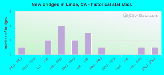
- New bridges - historical statistics
- 11900-1909
- 21920-1929
- 41930-1939
- 21940-1949
- 31950-1959
- 11960-1969
- 11990-1999
- 12000-2009


- Bridge Condition - Deck
- 44.4%Good
- 55.6%Fair

- Bridge Condition - Superstructure
- 22.2%Good
- 77.8%Fair

- Bridge Condition - Substructure
- 33.3%Good
- 66.7%Fair

- Bridge Condition - Channel
- 9.1%Excellent
- 18.2%Very good
- 36.4%Good
- 27.3%Satisfactory
- 9.1%Fair

- Bridge Condition - Culverts
- 33.3%Satisfactory
- 66.7%Poor
Find on map >> Show street view
Structure Number: 16 0035, Location: 03-YUB-070-13.23 (Lat: 39.126361, Lng: -121.579875), Route carried "on" structure: State highway 70, Year Built: 1956, Status: Open, Structure Length: 1.71m (5.61ft), Average Daily Traffic: 37,500 (year 2009), Truck Traffic: 12%, Average Future Daily Traffic: 63,175 (year 2040), Design Load: HS 20, Features Intersected: W70-BEALE ROAD OFF-RAMP
Minimum Vertical Clearance: 30+ m (98+ ft), Kilometerpoint: 13.230, Lanes on structure: 4, Lanes under structure: 1, Base Highway Network: Yes (, Subroute: 1), Owner: State Highway Agency, Approaching Roadway Width: 22.2m (72.8ft), Skew: 15 degrees, Material/Design: Concrete, Design/Construction: Box Beam or Girders - Multiple, Number Of Spans In Main Unit: 1, Length of Maximum Span: 17.1m (56.1ft), Curb-To-Curb Width: 22.2m (72.8ft), Out-to-Out Width: 24.6m (80.7ft)
Condition: Deck: Good, Superstructure: Good, Substructure: Good, Operating Rating: 92.3 metric tons, Method Used To Determine Operating Rating: Load Factor (LF), Inventory Rating: 55.4 metric tons, Method Used To Determine Inventory Rating: Load Factor (LF), Structural Evaluation: Better than present minimum criteria, Deck Geometry: Superior to present desirable criteria, Underclear: High priority of corrective action, Approach Roadway Alignment: Equal to present desirable criteria, Designated Inspection Frequency: Every 48 months, Inspection Date: Febuary 2022, Deck Structure Type: Concrete Cast-file-Place, Wearing Surface/Protective System: Wearing Surface: Bituminous
Find on map >> Show street view
Structure Number: 16C0037, Location: 3.9 MI E LINDA AVE (Lat: 39.128942, Lng: -121.471794), Route carried "on" structure: County highway , Year Built: 1935, Status: Open, Structure Length: 1.10m (3.61ft), Average Daily Traffic: 3,900 (year 2011), Truck Traffic: 5%, Average Future Daily Traffic: 3,855 (year 2041), Features Intersected: NORTH FORK REEDS CREEK, Facility Carried by Structure: NORTH BEALE RD
Minimum Vertical Clearance: 30+ m (98+ ft), Kilometerpoint: 0.000, Lanes on structure: 2, Owner: County Highway Agency, Approaching Roadway Width: 8.3m (27.2ft), Skew: 2 degrees, Material/Design: Concrete continuous, Design/Construction: Slab, Number Of Spans In Main Unit: 4, Length of Maximum Span: 2.7m (8.9ft), Curb-To-Curb Width: 17.4m (57.1ft), Out-to-Out Width: 17.4m (57.1ft)
Condition: Deck: Fair, Superstructure: Fair, Substructure: Fair, Channel: Satisfactory, Operating Rating: 26.9 metric tons, Method Used To Determine Operating Rating: Field evaluation and documented engineering judgment, Inventory Rating: 16.2 metric tons, Method Used To Determine Inventory Rating: Field evaluation and documented engineering judgment, Structural Evaluation: Meets minimum limits, Deck Geometry: Superior to present desirable criteria, Waterway Adequacy: Equal to present minimum criteria, Approach Roadway Alignment: Equal to present desirable criteria, Designated Inspection Frequency: Every 24 months, Inspection Date: March 2021
Find on map >> Show street view
Structure Number: 16C0038, Location: 4.8 MI E/O LINDA AVE (Lat: 39.129153, Lng: -121.455203), Route carried "on" structure: County highway , Year Built: 1935, Status: Open, Structure Length: 0.79m (2.59ft), Average Daily Traffic: 3,900 (year 2013), Truck Traffic: 10%, Average Future Daily Traffic: 4,271 (year 2041), Features Intersected: BEALE AFB SLOUGH, Facility Carried by Structure: NORTH BEALE RD
Minimum Vertical Clearance: 30+ m (98+ ft), Kilometerpoint: 0.000, Lanes on structure: 2, Owner: County Highway Agency, Approaching Roadway Width: 15.9m (52.2ft), Material/Design: Concrete continuous, Design/Construction: Slab, Number Of Spans In Main Unit: 2, Number Of Approach Spans: 1, Length of Maximum Span: 2.6m (8.5ft), Curb-To-Curb Width: 15.9m (52.2ft), Out-to-Out Width: 15.9m (52.2ft)
Condition: Deck: Fair, Superstructure: Fair, Substructure: Fair, Channel: Satisfactory, Operating Rating: 26.9 metric tons, Method Used To Determine Operating Rating: Field evaluation and documented engineering judgment, Inventory Rating: 16.2 metric tons, Method Used To Determine Inventory Rating: Field evaluation and documented engineering judgment, Structural Evaluation: Meets minimum limits, Deck Geometry: Superior to present desirable criteria, Waterway Adequacy: Somewhat better than minimum adequacy, Approach Roadway Alignment: Equal to present desirable criteria, Designated Inspection Frequency: Every 24 months, Inspection Date: March 2021
Find on map >> Show street view
Structure Number: 16C0053, Location: 1.1 MI S OF ERLE RD (Lat: 39.085500, Lng: -121.490269), Route carried "on" structure: County highway , Year Built: 1995, Status: Open, Structure Length: 3.01m (9.88ft), Average Daily Traffic: 570 (year 2006), Truck Traffic: 5%, Average Future Daily Traffic: 642 (year 2041), Design Load: HS 20+Mod, Features Intersected: HUTCHINSON CREEK, Facility Carried by Structure: VIRGINIA RD
Minimum Vertical Clearance: 30+ m (98+ ft), Kilometerpoint: 0.000, Lanes on structure: 2, Owner: County Highway Agency, Approaching Roadway Width: 9.1m (29.9ft), Skew: 1 degrees, Material/Design: Concrete continuous, Design/Construction: Slab, Number Of Spans In Main Unit: 3, Length of Maximum Span: 9.1m (29.9ft), Curb-To-Curb Width: 9.1m (29.9ft), Out-to-Out Width: 9.3m (30.5ft)
Condition: Deck: Good, Superstructure: Good, Substructure: Good, Channel: Very good, Operating Rating: 54.1 metric tons, Method Used To Determine Operating Rating: Assigned rating based on Load Factor Design (LFD) reported in metric tons, Inventory Rating: 32.4 metric tons, Method Used To Determine Inventory Rating: Assigned rating based on Load Factor Design (LFD) reported in metric tons, Structural Evaluation: Better than present minimum criteria, Deck Geometry: Equal to present minimum criteria, Waterway Adequacy: Equal to present desirable criteria, Approach Roadway Alignment: Equal to present desirable criteria, Designated Inspection Frequency: Every 48 months, Inspection Date: March 2019, Deck Structure Type: Concrete Cast-file-Place
Find on map >> Show street view
Structure Number: 16C0055, Location: 0.4 MI SOUTH ERLE RD (Lat: 39.094236, Lng: -121.497433), Route carried "on" structure: County highway , Year Built: 1920, Status: Open, Structure Length: 1.58m (5.18ft), Average Daily Traffic: 570 (year 2006), Truck Traffic: 5%, Average Future Daily Traffic: 655 (year 2041), Features Intersected: SOUTH FORK REEDS CREEK, Facility Carried by Structure: VIRGINIA RD
Minimum Vertical Clearance: 30+ m (98+ ft), Kilometerpoint: 0.000, Lanes on structure: 2, Owner: County Highway Agency, Approaching Roadway Width: 5.5m (18.0ft), Material/Design: Concrete continuous, Design/Construction: Slab, Number Of Spans In Main Unit: 3, Length of Maximum Span: 5.2m (17.1ft), Curb-To-Curb Width: 5.5m (18.0ft), Out-to-Out Width: 5.9m (19.4ft)
Condition: Deck: Fair, Superstructure: Fair, Substructure: Fair, Channel: Very good, Operating Rating: 26.9 metric tons, Method Used To Determine Operating Rating: Field evaluation and documented engineering judgment, Inventory Rating: 16.2 metric tons, Method Used To Determine Inventory Rating: Field evaluation and documented engineering judgment, Structural Evaluation: Meets minimum limits, Deck Geometry: High priority of replacement, Waterway Adequacy: Equal to present minimum criteria, Approach Roadway Alignment: Equal to present desirable criteria, Designated Inspection Frequency: Every 24 months, Inspection Date: March 2021, Deck Structure Type: Concrete Cast-file-Place, Wearing Surface/Protective System: Wearing Surface: Bituminous
Find on map >> Show street view
Structure Number: 16C0063, Location: .1 MI N/O N BEALE RD (Lat: 39.128583, Lng: -121.542214), Route carried "on" structure: County highway , Year Built: 1960, Status: Open, Structure Length: 0.70m (2.30ft), Average Daily Traffic: 3,400 (year 2008), Truck Traffic: 1%, Average Future Daily Traffic: 2,681 (year 2038), Features Intersected: DRAINAGE CANAL, Facility Carried by Structure: LINDA AVE
Minimum Vertical Clearance: 30+ m (98+ ft), Kilometerpoint: 0.000, Lanes on structure: 2, Owner: County Highway Agency, Approaching Roadway Width: 10.4m (34.1ft), Skew: 4 degrees, Material/Design: Concrete continuous, Design/Construction: Culvert, Number Of Spans In Main Unit: 2, Length of Maximum Span: 3.6m (11.8ft), Curb or Sidewalk Widths: Left: 0.2m (0.7ft), Right: 0.2m (0.7ft), Curb-To-Curb Width: 11.9m (39.0ft), Out-to-Out Width: 12.5m (41.0ft)
Condition: Channel: Good, Culverts: Satisfactory, Operating Rating: 40.5 metric tons, Method Used To Determine Operating Rating: Field evaluation and documented engineering judgment, Inventory Rating: 24.3 metric tons, Method Used To Determine Inventory Rating: Field evaluation and documented engineering judgment, Structural Evaluation: Equal to present minimum criteria, Deck Geometry: Somewhat better than minimum adequacy, Waterway Adequacy: Better than present minimum criteria, Approach Roadway Alignment: Meets minimum limits, Designated Inspection Frequency: Every 24 months, Inspection Date: March 2021, Deck Structure Type: Concrete Cast-file-Place, Wearing Surface/Protective System: Wearing Surface: Bituminous
Find on map >> Show street view
Structure Number: 16C0066, Location: .8 MI NW/O VIRGINIA RD (Lat: 39.109708, Lng: -121.507164), Route carried "on" structure: County highway , Year Built: 1930, Year Reconstructed: 2002, Status: Open, Structure Length: 0.91m (2.99ft), Average Daily Traffic: 800 (year 2011), Truck Traffic: 7%, Average Future Daily Traffic: 1,091 (year 2041), Features Intersected: NORTH FORK REEDS CREEK, Facility Carried by Structure: ERLE RD
Minimum Vertical Clearance: 30+ m (98+ ft), Kilometerpoint: 0.000, Lanes on structure: 2, Owner: County Highway Agency, Approaching Roadway Width: 6.4m (21.0ft), Material/Design: Steel continuous, Design/Construction: Stringer/Multi-beam, Number Of Spans In Main Unit: 2, Length of Maximum Span: 4.3m (14.1ft), Curb-To-Curb Width: 8.8m (28.9ft), Out-to-Out Width: 9.0m (29.5ft)
Condition: Deck: Good, Superstructure: Fair, Substructure: Fair, Channel: Good, Operating Rating: 30.1 metric tons, Method Used To Determine Operating Rating: Load Factor (LF), Inventory Rating: 18.1 metric tons, Method Used To Determine Inventory Rating: Load Factor (LF), Structural Evaluation: Somewhat better than minimum adequacy, Deck Geometry: Somewhat better than minimum adequacy, Waterway Adequacy: Better than present minimum criteria, Approach Roadway Alignment: Equal to present desirable criteria, Designated Inspection Frequency: Every 24 months, Inspection Date: March 2021, Deck Structure Type: Corrugated Steel, Wearing Surface/Protective System: Wearing Surface: Bituminous
Find on map >> Show street view
Structure Number: 16C0067, Location: 1 MI E/O VIRGINIA RD (Lat: 39.099947, Lng: -121.481739), Route carried "on" structure: County highway , Year Built: 1909, Year Reconstructed: 2004, Status: Open, Structure Length: 1.52m (4.99ft), Average Daily Traffic: 190 (year 2011), Truck Traffic: 5%, Average Future Daily Traffic: 546 (year 2041), Features Intersected: SOUTH FORK REEDS CREEK, Facility Carried by Structure: ERLE RD
Minimum Vertical Clearance: 30+ m (98+ ft), Kilometerpoint: 0.000, Lanes on structure: 2, Owner: County Highway Agency, Approaching Roadway Width: 5.7m (18.7ft), Material/Design: Steel continuous, Design/Construction: Stringer/Multi-beam, Number Of Spans In Main Unit: 3, Length of Maximum Span: 4.9m (16.1ft), Curb-To-Curb Width: 5.5m (18.0ft), Out-to-Out Width: 5.7m (18.7ft)
Condition: Deck: Good, Superstructure: Fair, Substructure: Fair, Channel: Fair, Operating Rating: 27.9 metric tons, Method Used To Determine Operating Rating: Load Factor (LF), Inventory Rating: 16.5 metric tons, Method Used To Determine Inventory Rating: Load Factor (LF), Structural Evaluation: Somewhat better than minimum adequacy, Deck Geometry: High priority of corrective action, Waterway Adequacy: Equal to present minimum criteria, Approach Roadway Alignment: Equal to present desirable criteria, Designated Inspection Frequency: Every 24 months, Inspection Date: March 2021, Deck Structure Type: Corrugated Steel, Wearing Surface/Protective System: Wearing Surface: Bituminous
Find on map >> Show street view
Structure Number: 16C0068, Location: 1.7 MI E/O VIRGINIA RD (Lat: 39.100122, Lng: -121.468822), Route carried "on" structure: County highway , Year Built: 1927, Status: Open, Structure Length: 0.94m (3.08ft), Average Daily Traffic: 190 (year 2011), Truck Traffic: 5%, Average Future Daily Traffic: 546 (year 2041), Features Intersected: SOUTH FORK REEDS CREEK, Facility Carried by Structure: ERLE RD
Minimum Vertical Clearance: 30+ m (98+ ft), Kilometerpoint: 0.000, Lanes on structure: 2, Owner: County Highway Agency, Approaching Roadway Width: 5.8m (19.0ft), Material/Design: Concrete continuous, Design/Construction: Slab, Number Of Spans In Main Unit: 2, Length of Maximum Span: 4.7m (15.4ft), Curb-To-Curb Width: 6.0m (19.7ft), Out-to-Out Width: 6.8m (22.3ft)
Condition: Deck: Fair, Superstructure: Fair, Substructure: Fair, Channel: Good, Operating Rating: 26.9 metric tons, Method Used To Determine Operating Rating: Field evaluation and documented engineering judgment, Inventory Rating: 16.2 metric tons, Method Used To Determine Inventory Rating: Field evaluation and documented engineering judgment, Structural Evaluation: Somewhat better than minimum adequacy, Deck Geometry: High priority of corrective action, Waterway Adequacy: Better than present minimum criteria, Approach Roadway Alignment: Equal to present desirable criteria, Designated Inspection Frequency: Every 24 months, Inspection Date: March 2021, Deck Structure Type: Concrete Cast-file-Place, Wearing Surface/Protective System: Wearing Surface: Bituminous
Find on map >> Show street view
Structure Number: 16C0103, Location: 1/4 MI E OF EDGEWATER CIR (Lat: 39.115639, Lng: -121.542611), Route carried "on" structure: County highway , Year Built: 2007, Status: Open, Structure Length: 2.16m (7.09ft), Average Daily Traffic: 1,200 (year 2007), Truck Traffic: 2%, Average Future Daily Traffic: 1,951 (year 2038), Features Intersected: OLIVEHURST CANAL, Facility Carried by Structure: RIVERBANK DRIVE
Minimum Vertical Clearance: 30+ m (98+ ft), Kilometerpoint: 0.000, Lanes on structure: 2, Owner: County Highway Agency, Approaching Roadway Width: 15.9m (52.2ft), Skew: 2 degrees, Material/Design: Prestressed concrete, Design/Construction: Slab, Number Of Spans In Main Unit: 1, Length of Maximum Span: 21.6m (70.9ft), Curb or Sidewalk Widths: Left: 1.7m (5.6ft), Right: 1.7m (5.6ft), Curb-To-Curb Width: 11.0m (36.1ft), Out-to-Out Width: 14.9m (48.9ft)
Condition: Deck: Fair, Superstructure: Fair, Substructure: Good, Channel: Excellent, Operating Rating: 54.1 metric tons, Method Used To Determine Operating Rating: Field evaluation and documented engineering judgment, Inventory Rating: 32.4 metric tons, Method Used To Determine Inventory Rating: Field evaluation and documented engineering judgment, Structural Evaluation: Somewhat better than minimum adequacy, Deck Geometry: Equal to present minimum criteria, Waterway Adequacy: Somewhat better than minimum adequacy, Approach Roadway Alignment: Equal to present desirable criteria, Designated Inspection Frequency: Every 24 months, Inspection Date: March 2021, Deck Structure Type: Concrete Cast-file-Place
Find on map >> Show street view
Structure Number: AFCABAEY10CB1, Location: 1.0 MILE WEST OF NORTH BE (Lat: 39.129889, Lng: -121.454000), Route carried "on" structure: ServiceOther road , Year Built: 1942, Status: Open, Structure Length: 0.93m (3.05ft), Average Daily Traffic: 50 (year 2016), Truck Traffic: 10%, Average Future Daily Traffic: 60 (year 2036), Features Intersected: REED'S CREEK TRIBUTARY, Facility Carried by Structure: PATROL ROAD
Minimum Vertical Clearance: 30+ m (98+ ft), Kilometerpoint: 0.000, Lanes on structure: 1, Owner: Air Force, Approaching Roadway Width: 3.7m (12.1ft), Material/Design: Steel, Design/Construction: Culvert, Number Of Spans In Main Unit: 3, Length of Maximum Span: 2.6m (8.5ft)
Condition: Channel: Good, Culverts: Poor, Operating Rating: 33.3 metric tons, Method Used To Determine Operating Rating: Field evaluation and documented engineering judgment, Inventory Rating: 24.5 metric tons, Method Used To Determine Inventory Rating: Field evaluation and documented engineering judgment, Structural Evaluation: Meets minimum limits, Waterway Adequacy: Better than present minimum criteria, Approach Roadway Alignment: Equal to present desirable criteria, Designated Inspection Frequency: Every 24 months, Inspection Date: September 2021, Bridge Improvement Cost: $260,000, Roadway Improvement Cost: $26,000, Total Project Cost: $390,000 ( Estimate for 2016)
Find on map >> Show street view
Structure Number: AFCABAEY10CB2, Location: 1.1 MILES WEST OF NORTH B (Lat: 39.129889, Lng: -121.455361), Route carried "on" structure: ServiceOther road , Year Built: 1942, Status: Open, Structure Length: 1.24m (4.07ft), Average Daily Traffic: 50 (year 2016), Truck Traffic: 10%, Average Future Daily Traffic: 60 (year 2036), Features Intersected: REED'S CREEK TRIBUTARY, Facility Carried by Structure: PATROL ROAD
Minimum Vertical Clearance: 30+ m (98+ ft), Kilometerpoint: 0.000, Lanes on structure: 1, Owner: Air Force, Approaching Roadway Width: 3.7m (12.1ft), Material/Design: Steel, Design/Construction: Culvert, Number Of Spans In Main Unit: 4, Length of Maximum Span: 2.6m (8.5ft)
Condition: Channel: Satisfactory, Culverts: Poor, Operating Rating: 33.3 metric tons, Method Used To Determine Operating Rating: Field evaluation and documented engineering judgment, Inventory Rating: 24.5 metric tons, Method Used To Determine Inventory Rating: Field evaluation and documented engineering judgment, Structural Evaluation: Meets minimum limits, Waterway Adequacy: Better than present minimum criteria, Approach Roadway Alignment: Equal to present desirable criteria, Designated Inspection Frequency: Every 24 months, Inspection Date: September 2021, Bridge Improvement Cost: $320,000, Roadway Improvement Cost: $32,000, Total Project Cost: $480,000 ( Estimate for 2016)
Find on map >> Show street view
Structure Number: 16 0035, Location: 03-YUB-070-13.23 (Lat: 39.126361, Lng: -121.579875), Route carried "under" structure: Ramp State highway 70, Year Built: 1956, Structure Length: 0. m, Average Daily Traffic: 2,000 (year 2006), Truck Traffic: 2%, Features Intersected: W70-BEALE ROAD OFF-RAMP
Minimum Vertical Clearance: 4.57m (14.99ft), Kilometerpoint: 13.230, Lanes on structure: 4, Lanes under structure: 1, Material/Design: Concrete, Design/Construction: Box Beam or Girders - Multiple, Length of Maximum Span: 17.1m (56.1ft)
Find on map >> Show street view
Structure Number: 16C0027, Location: 0.1 MI SW OF SR 70 (Lat: 39.123833, Lng: -121.577708), Route carried "under" structure: County highway , Year Built: 1956, Structure Length: 0. m, Average Daily Traffic: 7,250 (year 2008), Truck Traffic: 10%, Features Intersected: FEATHER RIVER BLVD, Facility Carried by Structure: UP RR & BNSF RY
Minimum Vertical Clearance: 4.42m (14.50ft), Kilometerpoint: 0.000, Lanes under structure: 4, Material/Design: Steel, Design/Construction: Girder and Floorbeam System, Length of Maximum Span: 18.3m (60.0ft)
Find on map >> Show street view
Structure Number: 16C004, Location: 0.9 MI E OF SH 70 (Lat: 39.125314, Lng: -121.569203), Route carried "under" structure: County highway , Year Built: 1935, Structure Length: 0. m, Average Daily Traffic: 25,000 (year 2008), Truck Traffic: 10%, Features Intersected: BEALE RD, Facility Carried by Structure: UP RR & AMTRAK
Minimum Vertical Clearance: 4.83m (15.85ft), Kilometerpoint: 0.000, Lanes under structure: 4, Material/Design: Concrete, Design/Construction: Stringer/Multi-beam, Length of Maximum Span: 12.5m (41.0ft)