Bridge Statistics for Lemont, Illinois (IL)
Condition, Traffic, Stress, Structural Evaluation, Project Costs
- National Bridge Inventory (NBI) Statistics
- 19Number of bridges
- 1,450ft / 442mTotal length
- 345,600Total average daily traffic
- 49,216Total average daily truck traffic
- National Bridge Inventory (NBI) Registered Bridges for Lemont
- No street view available for this location
- New bridges - historical statistics
- 11900-1909
- 11920-1929
- 41930-1939
- 21950-1959
- 21980-1989
- 21990-1999
- 62000-2009
- 12010-2019
- Reconstructed bridges - Historical Statistics
- 11980-1989
- 51990-1999
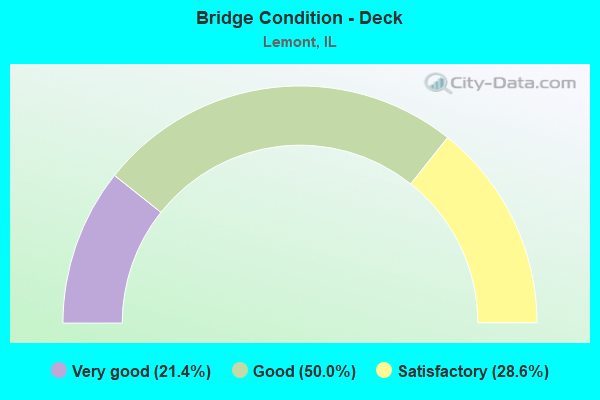
- Bridge Condition - Deck
- 21.4%Very good
- 50.0%Good
- 28.6%Satisfactory
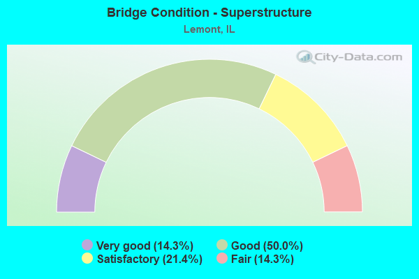
- Bridge Condition - Superstructure
- 14.3%Very good
- 50.0%Good
- 21.4%Satisfactory
- 14.3%Fair
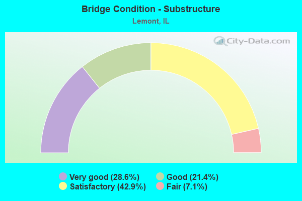
- Bridge Condition - Substructure
- 28.6%Very good
- 21.4%Good
- 42.9%Satisfactory
- 7.1%Fair
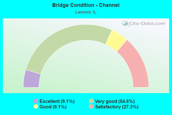
- Bridge Condition - Channel
- 9.1%Excellent
- 54.5%Very good
- 9.1%Good
- 27.3%Satisfactory
Find on map >> Show street view
Structure Number: 160425, Location: 0.4 M N 107TH ST (Lat: 41.701814, Lng: -87.939797), Route carried "on" structure: State highway 83, Year Built: 1934, Year Reconstructed: 1997, Status: Open, Structure Length: 34.45m (113.02ft), Average Daily Traffic: 29,200 (year 2021), Truck Traffic: 6%, Average Future Daily Traffic: 29,458 (year 2032), Design Load: HS 20, Features Intersected: S & S AND I&M CANALS
Minimum Vertical Clearance: 4.50m (14.76ft), Kilometerpoint: 51.659, Lanes on structure: 4, Base Highway Network: Yes, Owner: State Highway Agency, Approaching Roadway Width: 14.0m (45.9ft), Navigation Control: Yes ( Vertical Clearance: 11.6m (38.1ft), Horizontal Clearance: 48.8m (160.1ft)), Material/Design: Steel, Design/Construction: Truss - Thru, Number Of Spans In Main Unit: 1, Number Of Approach Spans: 18, Length of Maximum Span: 76.5m (251.0ft), Curb or Sidewalk Widths: Left: 0.0m, Right: 1.5m (4.9ft), Curb-To-Curb Width: 13.4m (44.0ft), Out-to-Out Width: 17.5m (57.4ft)
Condition: Deck: Good, Superstructure: Fair, Substructure: Satisfactory, Channel: Good, Operating Rating: 52.8 metric tons, Method Used To Determine Operating Rating: Load Factor (LF) rating reported by rating factor (RF) method using MS18 loading, Inventory Rating: 31.8 metric tons, Method Used To Determine Inventory Rating: Load Factor (LF) rating reported by rating factor (RF) method using MS18 loading, Structural Evaluation: Somewhat better than minimum adequacy, Deck Geometry: High priority of replacement, Waterway Adequacy: Equal to present desirable criteria, Approach Roadway Alignment: Equal to present desirable criteria, Designated Inspection Frequency: Every 24 months, Critical Feature Inspection Frequency: Every 24 months, Inspection Date: June 2021, Critical Feature Inspection Date: June 2021, Deck Structure Type: Concrete Cast-file-Place, Wearing Surface/Protective System: Wearing Surface: Epoxy Overlay, Deck Protection: Epoxy Coated Reinforcing
Find on map >> Show street view
Structure Number: 160426, Location: 0.1 M N 107TH ST (Lat: 41.699358, Lng: -87.937853), Route carried "on" structure: State highway 83, Year Built: 1959, Year Reconstructed: 1997, Status: Open, Structure Length: 10.18m (33.40ft), Average Daily Traffic: 29,200 (year 2021), Truck Traffic: 6%, Average Future Daily Traffic: 29,458 (year 2032), Design Load: HS 20, Features Intersected: RR - CN
Minimum Vertical Clearance: 30+ m (98+ ft), Kilometerpoint: 51.337, Lanes on structure: 4, Base Highway Network: Yes, Owner: State Highway Agency, Approaching Roadway Width: 18.4m (60.4ft), Skew: 21 degrees, Material/Design: Steel continuous, Design/Construction: Stringer/Multi-beam, Number Of Spans In Main Unit: 5, Length of Maximum Span: 24.5m (80.4ft), Curb or Sidewalk Widths: Left: 0.0m, Right: 1.8m (5.9ft), Curb-To-Curb Width: 18.4m (60.4ft), Out-to-Out Width: 21.1m (69.2ft)
Condition: Deck: Satisfactory, Superstructure: Satisfactory, Substructure: Satisfactory, Operating Rating: 57.7 metric tons, Method Used To Determine Operating Rating: Load Factor (LF) rating reported by rating factor (RF) method using MS18 loading, Inventory Rating: 34.7 metric tons, Method Used To Determine Inventory Rating: Load Factor (LF) rating reported by rating factor (RF) method using MS18 loading, Structural Evaluation: Equal to present minimum criteria, Deck Geometry: Somewhat better than minimum adequacy, Underclear: Equal to present minimum criteria, Approach Roadway Alignment: Equal to present desirable criteria, Designated Inspection Frequency: Every 24 months, Inspection Date: September 2021, Deck Structure Type: Concrete Cast-file-Place, Wearing Surface/Protective System: Deck Protection: Epoxy Coated Reinforcing
Find on map >> Show street view
Structure Number: 160427, Location: .1MI S OF 171,N JCT (Lat: 41.696433, Lng: -87.936397), Route carried "on" structure: State highway 83, Year Built: 1934, Year Reconstructed: 1997, Status: Open, Structure Length: 15.48m (50.79ft), Average Daily Traffic: 25,600 (year 2021), Truck Traffic: 7%, Average Future Daily Traffic: 29,458 (year 2032), Design Load: HS 20, Features Intersected: CAL SAG CHANNEL
Minimum Vertical Clearance: 4.62m (15.16ft), Kilometerpoint: 50.983, Lanes on structure: 4, Base Highway Network: Yes, Owner: State Highway Agency, Approaching Roadway Width: 13.4m (44.0ft), Navigation Control: Yes ( Vertical Clearance: 11.6m (38.1ft), Horizontal Clearance: 76.2m (250.0ft)), Material/Design: Steel, Design/Construction: Truss - Thru, Number Of Spans In Main Unit: 1, Number Of Approach Spans: 4, Length of Maximum Span: 92.8m (304.5ft), Curb or Sidewalk Widths: Left: 0.0m, Right: 1.8m (5.9ft), Curb-To-Curb Width: 13.4m (44.0ft), Out-to-Out Width: 16.9m (55.4ft)
Condition: Deck: Good, Superstructure: Fair, Substructure: Satisfactory, Channel: Very good, Operating Rating: 50.5 metric tons, Method Used To Determine Operating Rating: Load Factor (LF) rating reported by rating factor (RF) method using MS18 loading, Inventory Rating: 30.1 metric tons, Method Used To Determine Inventory Rating: Load Factor (LF) rating reported by rating factor (RF) method using MS18 loading, Structural Evaluation: Somewhat better than minimum adequacy, Deck Geometry: High priority of replacement, Waterway Adequacy: Equal to present desirable criteria, Approach Roadway Alignment: Better than present minimum criteria, Designated Inspection Frequency: Every 24 months, Critical Feature Inspection Frequency: Every 24 months, Inspection Date: June 2021, Critical Feature Inspection Date: June 2021, Deck Structure Type: Concrete Cast-file-Place, Wearing Surface/Protective System: Deck Protection: Epoxy Coated Reinforcing
Find on map >> Show street view
Structure Number: 160565, Location: 3 M S I55 P8 (Lat: 41.676064, Lng: -87.999467), Route carried "on" structure: City street , Year Built: 1925, Year Reconstructed: 1993, Status: Open, Structure Length: 2.42m (7.94ft), Average Daily Traffic: 1,050 (year 2018), Truck Traffic: 9%, Average Future Daily Traffic: 1,391 (year 2032), Design Load: HS 20, Features Intersected: I&M CANAL, Facility Carried by Structure: STEPHEN ST
Minimum Vertical Clearance: 30+ m (98+ ft), Kilometerpoint: 0.274, Lanes on structure: 2, Owner: City or Municipal Highway Agency, Approaching Roadway Width: 9.1m (29.9ft), Material/Design: Prestressed concrete, Design/Construction: Stringer/Multi-beam, Number Of Spans In Main Unit: 1, Length of Maximum Span: 23.0m (75.5ft), Curb or Sidewalk Widths: Left: 3.4m (11.2ft), Right: 3.4m (11.2ft), Curb-To-Curb Width: 9.1m (29.9ft), Out-to-Out Width: 16.0m (52.5ft)
Condition: Deck: Very good, Superstructure: Good, Substructure: Good, Channel: Very good, Operating Rating: 62.2 metric tons, Method Used To Determine Operating Rating: Load Factor (LF) rating reported by rating factor (RF) method using MS18 loading, Inventory Rating: 37.3 metric tons, Method Used To Determine Inventory Rating: Load Factor (LF) rating reported by rating factor (RF) method using MS18 loading, Structural Evaluation: Better than present minimum criteria, Deck Geometry: Somewhat better than minimum adequacy, Waterway Adequacy: Superior to present desirable criteria, Approach Roadway Alignment: Equal to present desirable criteria, Designated Inspection Frequency: Every 48 months, Inspection Date: October 2019, Deck Structure Type: Concrete Cast-file-Place, Wearing Surface/Protective System: Wearing Surface: Other, Deck Protection: Epoxy Coated Reinforcing
Find on map >> Show street view
Structure Number: 161022, Location: 0.2 M S IL 171 (Lat: 41.695572, Lng: -87.936236), Route carried "on" structure: State highway 83, Year Built: 1935, Year Reconstructed: 1997, Status: Open, Structure Length: 15.31m (50.23ft), Average Daily Traffic: 25,600 (year 2021), Truck Traffic: 7%, Average Future Daily Traffic: 29,458 (year 2032), Design Load: HS 20+Mod, Features Intersected: CAL SAG EXTENSION
Minimum Vertical Clearance: 30+ m (98+ ft), Kilometerpoint: 50.886, Lanes on structure: 4, Base Highway Network: Yes, Owner: State Highway Agency, Approaching Roadway Width: 14.6m (47.9ft), Material/Design: Steel continuous, Design/Construction: Stringer/Multi-beam, Number Of Spans In Main Unit: 10, Length of Maximum Span: 15.3m (50.2ft), Curb or Sidewalk Widths: Left: 0.0m, Right: 1.8m (5.9ft), Curb-To-Curb Width: 14.6m (47.9ft), Out-to-Out Width: 17.4m (57.1ft)
Condition: Deck: Good, Superstructure: Good, Substructure: Satisfactory, Channel: Very good, Operating Rating: 89.1 metric tons, Method Used To Determine Operating Rating: Load Factor (LF) rating reported by rating factor (RF) method using MS18 loading, Inventory Rating: 68.0 metric tons, Method Used To Determine Inventory Rating: Load Factor (LF) rating reported by rating factor (RF) method using MS18 loading, Structural Evaluation: Equal to present minimum criteria, Deck Geometry: High priority of replacement, Waterway Adequacy: Superior to present desirable criteria, Approach Roadway Alignment: Equal to present desirable criteria, Designated Inspection Frequency: Every 24 months, Inspection Date: June 2021, Deck Structure Type: Concrete Cast-file-Place, Wearing Surface/Protective System: Deck Protection: Epoxy Coated Reinforcing
Find on map >> Show street view
Structure Number: 161346, Location: 0.3M W of Stephen St (Lat: 41.673197, Lng: -88.005011), Route carried "on" structure: Other road , Year Built: 1950, Status: Open, Structure Length: 0.70m (2.30ft), Average Daily Traffic: 6,050 (year 2020), Truck Traffic: 21%, Average Future Daily Traffic: 16,800 (year 2037), Features Intersected: DITCH, Facility Carried by Structure: NEW AVE
Minimum Vertical Clearance: 30+ m (98+ ft), Kilometerpoint: 2.156, Lanes on structure: 2, Base Highway Network: Yes, Owner: State Highway Agency, Approaching Roadway Width: 7.3m (24.0ft), Material/Design: Concrete, Design/Construction: Culvert, Number Of Spans In Main Unit: 2, Length of Maximum Span: 3.0m (9.8ft)
Condition: Channel: Satisfactory, Culverts: Satisfactory, Operating Rating: 54.1 metric tons, Method Used To Determine Operating Rating: Field evaluation and documented engineering judgment, Inventory Rating: 32.4 metric tons, Method Used To Determine Inventory Rating: Field evaluation and documented engineering judgment, Structural Evaluation: Equal to present minimum criteria, Waterway Adequacy: Equal to present desirable criteria, Approach Roadway Alignment: Equal to present desirable criteria, Designated Inspection Frequency: Every 24 months, Inspection Date: December 2020
Find on map >> Show street view
Structure Number: 162504, Location: 0.30 M S DUPAGE CO (Lat: 41.682269, Lng: -88.002514), Route carried "on" structure: Other road , Year Built: 1983, Status: Open, Structure Length: 102.17m (335.20ft), Average Daily Traffic: 23,300 (year 2018), Truck Traffic: 8%, Average Future Daily Traffic: 20,085 (year 2032), Design Load: HS 20, Features Intersected: DES P RIV, CANAL, RR, Facility Carried by Structure: LEMONT RD
Minimum Vertical Clearance: 30+ m (98+ ft), Kilometerpoint: 0.418, Lanes on structure: 4, Base Highway Network: Yes, Owner: State Highway Agency, Approaching Roadway Width: 18.3m (60.0ft), Skew: 31 degrees, Navigation Control: Yes ( Vertical Clearance: 14.3m (46.9ft), Horizontal Clearance: 48.8m (160.1ft)), Material/Design: Steel continuous, Design/Construction: Stringer/Multi-beam, Number Of Spans In Main Unit: 18, Number Of Approach Spans: 1, Length of Maximum Span: 91.4m (299.9ft), Curb or Sidewalk Widths: Left: 1.5m (4.9ft), Right: 0.0m, Curb-To-Curb Width: 18.3m (60.0ft), Out-to-Out Width: 21.7m (71.2ft)
Condition: Deck: Satisfactory, Superstructure: Satisfactory, Substructure: Fair, Channel: Very good, Operating Rating: 52.2 metric tons, Method Used To Determine Operating Rating: Load Factor (LF) rating reported by rating factor (RF) method using MS18 loading, Inventory Rating: 31.4 metric tons, Method Used To Determine Inventory Rating: Load Factor (LF) rating reported by rating factor (RF) method using MS18 loading, Structural Evaluation: Somewhat better than minimum adequacy, Deck Geometry: Somewhat better than minimum adequacy, Underclear: Equal to present desirable criteria, Waterway Adequacy: Equal to present desirable criteria, Approach Roadway Alignment: Equal to present desirable criteria, Designated Inspection Frequency: Every 24 months, Inspection Date: September 2021, Deck Structure Type: Concrete Cast-file-Place, Wearing Surface/Protective System: Wearing Surface: Latex Concrete, Deck Protection: Epoxy Coated Reinforcing
Find on map >> Show street view
Structure Number: 162528, Location: NORTH LEMONT (Lat: 41.680183, Lng: -88.001939), Route carried "on" structure: City street , Year Built: 1985, Status: Open, Structure Length: 9.57m (31.40ft), Average Daily Traffic: 1,450 (year 2018), Truck Traffic: 28%, Average Future Daily Traffic: 4,026 (year 2032), Design Load: HS 20, Features Intersected: DESPLAINES RIVER, Facility Carried by Structure: OLD LEMONT ROAD
Minimum Vertical Clearance: 30+ m (98+ ft), Kilometerpoint: 0.435, Lanes on structure: 2, Owner: City or Municipal Highway Agency, Approaching Roadway Width: 10.2m (33.5ft), Material/Design: Prestressed concrete continuous, Design/Construction: Stringer/Multi-beam, Number Of Spans In Main Unit: 5, Length of Maximum Span: 25.6m (84.0ft), Curb-To-Curb Width: 8.5m (27.9ft), Out-to-Out Width: 9.4m (30.8ft)
Condition: Deck: Good, Superstructure: Good, Substructure: Very good, Channel: Satisfactory, Operating Rating: 64.8 metric tons, Method Used To Determine Operating Rating: Allowable Stress (AS) rating reported by rating factor (RF) method using MS18 loading, Inventory Rating: 39.5 metric tons, Method Used To Determine Inventory Rating: Allowable Stress (AS) rating reported by rating factor (RF) method using MS18 loading, Structural Evaluation: Better than present minimum criteria, Deck Geometry: Somewhat better than minimum adequacy, Waterway Adequacy: Equal to present desirable criteria, Approach Roadway Alignment: Equal to present minimum criteria, Designated Inspection Frequency: Every 48 months, Underwater Inspection Frequency: Every 60 months, Inspection Date: October 2019, Underwater Inspection Date: October 2019, Deck Structure Type: Concrete Cast-file-Place, Wearing Surface/Protective System: Deck Protection: Epoxy Coated Reinforcing
Find on map >> Show street view
Structure Number: 162628, Location: 1.5M N OF IL171 (Lat: 41.656269, Lng: -88.018425), Route carried "on" structure: Other road , Year Built: 2007, Status: Open, Structure Length: 6.71m (22.01ft), Average Daily Traffic: 2,100 (year 2019), Truck Traffic: 35%, Average Future Daily Traffic: 11,639 (year 2032), Design Load: HS 20, Features Intersected: I 355, Facility Carried by Structure: 127TH STREET
Minimum Vertical Clearance: 30+ m (98+ ft), Kilometerpoint: 0.821, Lanes on structure: 4, Lanes under structure: 6, Toll: On toll road, Owner: City or Municipal Highway Agency, Approaching Roadway Width: 23.8m (78.1ft), Skew: 20 degrees, Material/Design: Prestressed concrete continuous, Design/Construction: Stringer/Multi-beam, Number Of Spans In Main Unit: 2, Length of Maximum Span: 33.5m (109.9ft), Curb-To-Curb Width: 23.8m (78.1ft), Out-to-Out Width: 26.9m (88.3ft)
Condition: Deck: Good, Superstructure: Very good, Substructure: Good, Operating Rating: 67.1 metric tons, Method Used To Determine Operating Rating: Load Factor (LF) rating reported by rating factor (RF) method using MS18 loading, Inventory Rating: 40.2 metric tons, Method Used To Determine Inventory Rating: Load Factor (LF) rating reported by rating factor (RF) method using MS18 loading, Structural Evaluation: Better than present minimum criteria, Deck Geometry: Superior to present desirable criteria, Approach Roadway Alignment: Equal to present desirable criteria, Designated Inspection Frequency: Every 24 months, Inspection Date: April 2020, Deck Structure Type: Concrete Cast-file-Place
Find on map >> Show street view
Structure Number: 162629, Location: .5M S OF BLUFF RD (Lat: 41.680081, Lng: -88.030947), Route carried "on" structure: Interstate 355, Year Built: 2007, Status: Open, Structure Length: 200.95m (659.28ft), Average Daily Traffic: 65,900 (year 2021), Truck Traffic: 15%, Average Future Daily Traffic: 87,567 (year 2032), Design Load: HS 20, Features Intersected: DESPLAINES RIVER VAL
Minimum Vertical Clearance: 30+ m (98+ ft), Kilometerpoint: 17.783, Lanes on structure: 6, Base Highway Network: Yes, Toll: On toll road, Owner: State Toll Authority, Approaching Roadway Width: 18.3m (60.0ft), Material/Design: Prestressed concrete continuous, Design/Construction: Stringer/Multi-beam, Number Of Spans In Main Unit: 35, Length of Maximum Span: 82.5m (270.7ft), Curb-To-Curb Width: 18.3m (60.0ft), Out-to-Out Width: 19.4m (63.6ft)
Condition: Deck: Good, Superstructure: Good, Substructure: Satisfactory, Channel: Very good, Operating Rating: 57.0 metric tons, Method Used To Determine Operating Rating: Load Factor (LF) rating reported by rating factor (RF) method using MS18 loading, Inventory Rating: 34.0 metric tons, Method Used To Determine Inventory Rating: Load Factor (LF) rating reported by rating factor (RF) method using MS18 loading, Structural Evaluation: Equal to present minimum criteria, Deck Geometry: High priority of replacement, Waterway Adequacy: Superior to present desirable criteria, Approach Roadway Alignment: Equal to present desirable criteria, Designated Inspection Frequency: Every 24 months, Inspection Date: June 2020, Deck Structure Type: Concrete Cast-file-Place
Find on map >> Show street view
Structure Number: 167356, Location: .16 MI. N. OF MAIN (Lat: 41.674850, Lng: -88.002747), Route carried "on" structure: City street , Year Built: 1991, Status: Open, Structure Length: 2.86m (9.38ft), Average Daily Traffic: 600 (year 2018), Truck Traffic: 12%, Average Future Daily Traffic: 5,159 (year 2032), Design Load: HS 20, Features Intersected: I&M CANAL, Facility Carried by Structure: ED BOSSERT DR
Minimum Vertical Clearance: 30+ m (98+ ft), Kilometerpoint: 0.048, Lanes on structure: 2, Owner: City or Municipal Highway Agency, Approaching Roadway Width: 7.3m (24.0ft), Material/Design: Prestressed concrete, Design/Construction: Stringer/Multi-beam, Number Of Spans In Main Unit: 1, Length of Maximum Span: 27.1m (88.9ft), Curb or Sidewalk Widths: Left: 1.5m (4.9ft), Right: 1.5m (4.9ft), Curb-To-Curb Width: 7.3m (24.0ft), Out-to-Out Width: 11.0m (36.1ft)
Condition: Deck: Good, Superstructure: Good, Substructure: Very good, Channel: Very good, Operating Rating: 89.1 metric tons, Method Used To Determine Operating Rating: Load Factor (LF) rating reported by rating factor (RF) method using MS18 loading, Inventory Rating: 37.9 metric tons, Method Used To Determine Inventory Rating: Load Factor (LF) rating reported by rating factor (RF) method using MS18 loading, Structural Evaluation: Better than present minimum criteria, Deck Geometry: Meets minimum limits, Waterway Adequacy: Superior to present desirable criteria, Approach Roadway Alignment: Equal to present desirable criteria, Designated Inspection Frequency: Every 48 months, Inspection Date: October 2019, Deck Structure Type: Concrete Cast-file-Place, Wearing Surface/Protective System: Deck Protection: Epoxy Coated Reinforcing
Find on map >> Show street view
Structure Number: 167357, Location: 0.6M S ARCHER (Lat: 41.654575, Lng: -87.962975), Route carried "on" structure: Other road , Year Built: 2003, Status: Open, Structure Length: 2.62m (8.60ft), Average Daily Traffic: 5,900 (year 2018), Truck Traffic: 5%, Average Future Daily Traffic: 5,560 (year 2032), Design Load: HS 20, Features Intersected: PINE NEEDLES DR, Facility Carried by Structure: FAU-1024 (DERBY RD
Minimum Vertical Clearance: 30+ m (98+ ft), Kilometerpoint: 1.239, Lanes on structure: 2, Lanes under structure: 2, Owner: City or Municipal Highway Agency, Approaching Roadway Width: 9.1m (29.9ft), Material/Design: Prestressed concrete, Design/Construction: Stringer/Multi-beam, Number Of Spans In Main Unit: 1, Length of Maximum Span: 24.7m (81.0ft), Curb or Sidewalk Widths: Left: 1.6m (5.2ft), Right: 1.6m (5.2ft), Curb-To-Curb Width: 9.1m (29.9ft), Out-to-Out Width: 13.0m (42.7ft)
Condition: Deck: Very good, Superstructure: Satisfactory, Substructure: Very good, Operating Rating: 77.1 metric tons, Method Used To Determine Operating Rating: Load Factor (LF) rating reported by rating factor (RF) method using MS18 loading, Inventory Rating: 33.7 metric tons, Method Used To Determine Inventory Rating: Load Factor (LF) rating reported by rating factor (RF) method using MS18 loading, Structural Evaluation: Equal to present minimum criteria, Deck Geometry: High priority of corrective action, Approach Roadway Alignment: Equal to present desirable criteria, Designated Inspection Frequency: Every 24 months, Inspection Date: October 2020, Deck Structure Type: Concrete Cast-file-Place, Wearing Surface/Protective System: Deck Protection: Epoxy Coated Reinforcing
Find on map >> Show street view
Structure Number: 220053, Location: 0.6 M N OF ILL 171 (Lat: 41.704633, Lng: -87.941958), Route carried "on" structure: State highway 83, Year Built: 1934, Year Reconstructed: 1997, Status: Open, Structure Length: 15.49m (50.82ft), Average Daily Traffic: 24,700 (year 2021), Truck Traffic: 18%, Average Future Daily Traffic: 31,303 (year 2032), Design Load: HS 20+Mod, Features Intersected: DES PLAINES RIVER
Minimum Vertical Clearance: 30+ m (98+ ft), Kilometerpoint: 52.029, Lanes on structure: 4, Base Highway Network: Yes, Owner: State Highway Agency, Approaching Roadway Width: 14.6m (47.9ft), Material/Design: Prestressed concrete continuous, Design/Construction: Stringer/Multi-beam, Number Of Spans In Main Unit: 8, Length of Maximum Span: 19.2m (63.0ft), Curb or Sidewalk Widths: Left: 0.0m, Right: 1.5m (4.9ft), Curb-To-Curb Width: 15.8m (51.8ft), Out-to-Out Width: 18.2m (59.7ft)
Condition: Deck: Satisfactory, Superstructure: Good, Substructure: Satisfactory, Channel: Satisfactory, Operating Rating: 78.4 metric tons, Method Used To Determine Operating Rating: Load Factor (LF) rating reported by rating factor (RF) method using MS18 loading, Inventory Rating: 45.4 metric tons, Method Used To Determine Inventory Rating: Load Factor (LF) rating reported by rating factor (RF) method using MS18 loading, Structural Evaluation: Equal to present minimum criteria, Deck Geometry: Meets minimum limits, Waterway Adequacy: Equal to present desirable criteria, Approach Roadway Alignment: Equal to present desirable criteria, Designated Inspection Frequency: Every 24 months, Inspection Date: September 2020, Deck Structure Type: Concrete Cast-file-Place, Wearing Surface/Protective System: Deck Protection: Epoxy Coated Reinforcing
Find on map >> Show street view
Structure Number: 221069, Location: 0.7 M N OF IL 171 (Lat: 41.707881, Lng: -87.944417), Route carried "on" structure: State highway 83, Year Built: 1997, Status: Open, Structure Length: 19.35m (63.48ft), Average Daily Traffic: 24,700 (year 2021), Truck Traffic: 18%, Average Future Daily Traffic: 31,303 (year 2032), Design Load: HS 20+Mod, Features Intersected: RR - BNSF
Minimum Vertical Clearance: 30+ m (98+ ft), Kilometerpoint: 52.447, Lanes on structure: 4, Base Highway Network: Yes, Owner: State Highway Agency, Approaching Roadway Width: 15.8m (51.8ft), Skew: 1 degrees, Material/Design: Steel continuous, Design/Construction: Stringer/Multi-beam, Number Of Spans In Main Unit: 7, Length of Maximum Span: 32.0m (105.0ft), Curb or Sidewalk Widths: Left: 0.0m, Right: 1.5m (4.9ft), Curb-To-Curb Width: 15.8m (51.8ft), Out-to-Out Width: 18.2m (59.7ft)
Condition: Deck: Satisfactory, Superstructure: Good, Substructure: Good, Operating Rating: 73.5 metric tons, Method Used To Determine Operating Rating: Load Factor (LF) rating reported by rating factor (RF) method using MS18 loading, Inventory Rating: 44.1 metric tons, Method Used To Determine Inventory Rating: Load Factor (LF) rating reported by rating factor (RF) method using MS18 loading, Structural Evaluation: Better than present minimum criteria, Deck Geometry: Meets minimum limits, Underclear: Superior to present desirable criteria, Approach Roadway Alignment: Equal to present desirable criteria, Designated Inspection Frequency: Every 24 months, Inspection Date: September 2021, Deck Structure Type: Concrete Cast-file-Place, Wearing Surface/Protective System: Deck Protection: Epoxy Coated Reinforcing
Find on map >> Show street view
Structure Number: 993028, Location: NW of Ill. Rte. 171 (Lat: 41.641308, Lng: -88.004703), Route carried "on" structure: Other road , Year Built: 2014, Status: Open, Structure Length: 3.51m (11.52ft), Average Daily Traffic: 5,500 (year 2019), Truck Traffic: 10%, Average Future Daily Traffic: 9,923 (year 2032), Design Load: HS 20, Features Intersected: LONG RUN CREEK, Facility Carried by Structure: 135TH STREET
Minimum Vertical Clearance: 30+ m (98+ ft), Kilometerpoint: 10.042, Lanes on structure: 4, Owner: County Highway Agency, Approaching Roadway Width: 20.7m (67.9ft), Skew: 20 degrees, Material/Design: Steel continuous, Design/Construction: Stringer/Multi-beam, Number Of Spans In Main Unit: 2, Length of Maximum Span: 17.2m (56.4ft), Curb-To-Curb Width: 20.7m (67.9ft), Out-to-Out Width: 21.7m (71.2ft)
Condition: Deck: Very good, Superstructure: Very good, Substructure: Very good, Channel: Excellent, Operating Rating: 42.1 metric tons, Method Used To Determine Operating Rating: Assigned ratings based on Load and Resistance Factor Design (LRFD) reported by rating factor (RF) using HL93 loadings, Inventory Rating: 32.4 metric tons, Method Used To Determine Inventory Rating: Assigned ratings based on Load and Resistance Factor Design (LRFD) reported by rating factor (RF) using HL93 loadings, Structural Evaluation: Equal to present desirable criteria, Deck Geometry: Superior to present desirable criteria, Waterway Adequacy: Superior to present desirable criteria, Approach Roadway Alignment: Equal to present desirable criteria, Designated Inspection Frequency: Every 48 months, Inspection Date: April 2021, Deck Structure Type: Concrete Cast-file-Place, Wearing Surface/Protective System: Deck Protection: Epoxy Coated Reinforcing
Find on map >> Show street view
Structure Number: 160564, Location: N OF LEMONT P8 (Lat: 41.678142, Lng: -88.000628), Route carried "under" structure: City street , Year Built: 1900, Structure Length: 0. m, Average Daily Traffic: 1,050 (year 2018), Truck Traffic: 9%, Features Intersected: STEPHEN ST, Facility Carried by Structure: AT&SF RR
Minimum Vertical Clearance: 4.17m (13.68ft), Kilometerpoint: 0.048, Lanes under structure: 2, Material/Design: Steel, Length of Maximum Span: 23.8m (78.1ft)
Find on map >> Show street view
Structure Number: 162628, Location: 1.5M N OF IL171 (Lat: 41.656269, Lng: -88.018342), Route carried "under" structure: Interstate 355, Year Built: 2007, Structure Length: 0. m, Average Daily Traffic: 65,900 (year 2020), Truck Traffic: 25%, Features Intersected: I 355, Facility Carried by Structure: 127TH STREET
Minimum Vertical Clearance: 5.03m (16.50ft), Kilometerpoint: 14.870, Lanes on structure: 4, Lanes under structure: 6, Toll: On toll road, Material/Design: Prestressed concrete continuous, Design/Construction: Stringer/Multi-beam, Length of Maximum Span: 33.5m (109.9ft)
Find on map >> Show street view
Structure Number: 167357, Location: 0.6M S ARCHER (Lat: 41.654436, Lng: -87.962961), Route carried "under" structure: City street , Year Built: 2003, Structure Length: 0. m, Average Daily Traffic: 1,000 (year 2014), Features Intersected: PINE NEEDLES DR, Facility Carried by Structure: FAU-1024 (DERBY RD
Minimum Vertical Clearance: 3.12m (10.24ft), Kilometerpoint: 0.547, Lanes on structure: 2, Lanes under structure: 2, Material/Design: Prestressed concrete, Design/Construction: Stringer/Multi-beam, Length of Maximum Span: 24.7m (81.0ft)
Find on map >> Show street view
Structure Number: 990334, Location: 1M E OF JOLIET RD (Lat: 41.690697, Lng: -88.030003), Route carried "under" structure: Other road , Year Built: 2007, Structure Length: 0. m, Average Daily Traffic: 6,800 (year 2016), Truck Traffic: 22%, Features Intersected: INTERNATIONAL PRKY, Facility Carried by Structure: I-355 SB
Minimum Vertical Clearance: 4.65m (15.26ft), Kilometerpoint: 1.561, Lanes on structure: 4, Lanes under structure: 2, Toll: On toll road, Material/Design: Steel continuous, Design/Construction: Stringer/Multi-beam, Length of Maximum Span: 39.5m (129.6ft)