Bridge Statistics for Lebanon, Connecticut (CT)
Condition, Traffic, Stress, Structural Evaluation, Project Costs
- National Bridge Inventory (NBI) Statistics
- 20Number of bridges
- 98ft / 30.2mTotal length
- 68,032Total average daily traffic
- 3,797Total average daily truck traffic
- National Bridge Inventory (NBI) Registered Bridges for Lebanon
- No street view available for this location
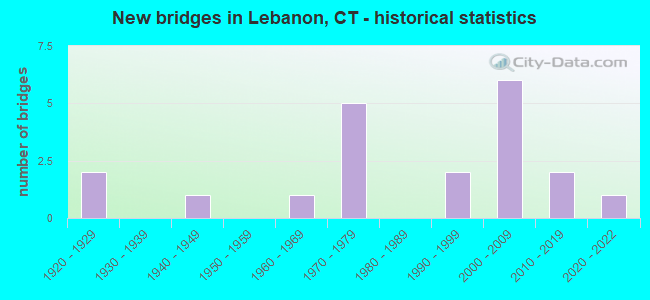
- New bridges - historical statistics
- 21920-1929
- 11940-1949
- 11960-1969
- 51970-1979
- 21990-1999
- 62000-2009
- 22010-2019
- 12020-2022

- Reconstructed bridges - Historical Statistics
- 11970-1979
- 01980-1989
- 01990-1999
- 22000-2009


- Bridge Condition - Deck
- 11.1%Very good
- 88.9%Good

- Bridge Condition - Superstructure
- 16.7%Very good
- 58.3%Good
- 16.7%Satisfactory
- 8.3%Fair

- Bridge Condition - Substructure
- 16.7%Very good
- 58.3%Good
- 25.0%Satisfactory

- Bridge Condition - Channel
- 12.5%Very good
- 37.5%Good
- 37.5%Satisfactory
- 12.5%Fair

- Bridge Condition - Culverts
- 28.6%Very good
- 57.1%Good
- 14.3%Satisfactory
Find on map >> Show street view
Structure Number: 854, Location: 1.2 MI WEST OF RTE 207 (Lat: 41.601603, Lng: -72.280969), Route carried "on" structure: State highway 16, Year Built: 1948, Status: Open, Structure Length: 0.64m (2.10ft), Average Daily Traffic: 2,700 (year 2018), Truck Traffic: 3%, Average Future Daily Traffic: 4,012 (year 2038), Design Load: H 20, Features Intersected: BARTLETT BROOK
Minimum Vertical Clearance: 30+ m (98+ ft), Kilometerpoint: 25.476, Lanes on structure: 2, Owner: State Highway Agency, Approaching Roadway Width: 6.7m (22.0ft), Material/Design: Concrete continuous, Design/Construction: Culvert, Number Of Spans In Main Unit: 2, Length of Maximum Span: 3.0m (9.8ft)
Condition: Channel: Satisfactory, Culverts: Good, Operating Rating: 57.7 metric tons, Method Used To Determine Operating Rating: Load and Resistance Factor Rating (LRFR) rating reported by rating factor(RF) method using HL-93 loadings, Inventory Rating: 44.4 metric tons, Method Used To Determine Inventory Rating: Load and Resistance Factor Rating (LRFR) rating reported by rating factor(RF) method using HL-93 loadings, Structural Evaluation: Better than present minimum criteria, Waterway Adequacy: Equal to present minimum criteria, Approach Roadway Alignment: Equal to present desirable criteria, Designated Inspection Frequency: Every 24 months, Inspection Date: April 2021
Find on map >> Show street view
Structure Number: 1631, Location: AT BOZRAH TL (Lat: 41.576017, Lng: -72.202233), Route carried "on" structure: State highway 608, Year Built: 1926, Year Reconstructed: 1984, Status: Open, Structure Length: 1.49m (4.89ft), Average Daily Traffic: 950 (year 2015), Truck Traffic: 2%, Average Future Daily Traffic: 1,412 (year 2035), Design Load: HS 20, Features Intersected: YANTIC RIVER
Minimum Vertical Clearance: 30+ m (98+ ft), Kilometerpoint: 0.274, Lanes on structure: 2, Owner: State Highway Agency, Approaching Roadway Width: 9.1m (29.9ft), Skew: 1 degrees, Material/Design: Prestressed concrete, Design/Construction: Box Beam or Girders - Multiple, Number Of Spans In Main Unit: 1, Length of Maximum Span: 13.1m (43.0ft), Curb or Sidewalk Widths: Left: 0.7m (2.3ft), Right: 0.7m (2.3ft), Curb-To-Curb Width: 9.2m (30.2ft), Out-to-Out Width: 10.7m (35.1ft)
Condition: Deck: Good, Superstructure: Satisfactory, Substructure: Satisfactory, Channel: Satisfactory, Operating Rating: 69.4 metric tons, Method Used To Determine Operating Rating: Load Factor (LF), Inventory Rating: 41.5 metric tons, Method Used To Determine Inventory Rating: Load Factor (LF), Structural Evaluation: Equal to present minimum criteria, Deck Geometry: Equal to present minimum criteria, Waterway Adequacy: Equal to present minimum criteria, Approach Roadway Alignment: Equal to present desirable criteria, Designated Inspection Frequency: Every 24 months, Inspection Date: July 2020, Deck Structure Type: Other, Wearing Surface/Protective System: Wearing Surface: Bituminous, Membrane: Built-up
Find on map >> Show street view
Structure Number: 1864, Location: 1.2 MILES WEST OF EXIT 22 (Lat: 41.566531, Lng: -72.231683), Route carried "on" structure: State highway 2, Year Built: 1970, Status: Open, Structure Length: 2.87m (9.42ft), Average Daily Traffic: 11,900 (year 2014), Truck Traffic: 6%, Average Future Daily Traffic: 17,682 (year 2034), Design Load: HS 20, Features Intersected: CAMP MOWEEN ROAD
Minimum Vertical Clearance: 30+ m (98+ ft), Kilometerpoint: 47.733, Lanes on structure: 2, Lanes under structure: 2, Base Highway Network: Yes, Owner: State Highway Agency, Approaching Roadway Width: 12.8m (42.0ft), Skew: 1 degrees, Material/Design: Prestressed concrete, Design/Construction: Stringer/Multi-beam, Number Of Spans In Main Unit: 1, Length of Maximum Span: 27.1m (88.9ft), Curb or Sidewalk Widths: Left: 0.5m (1.6ft), Right: 0.5m (1.6ft), Curb-To-Curb Width: 13.1m (43.0ft), Out-to-Out Width: 14.2m (46.6ft)
Condition: Deck: Good, Superstructure: Good, Substructure: Good, Operating Rating: 50.2 metric tons, Method Used To Determine Operating Rating: Load and Resistance Factor Rating (LRFR) rating reported by rating factor(RF) method using HL-93 loadings, Inventory Rating: 36.0 metric tons, Method Used To Determine Inventory Rating: Load and Resistance Factor Rating (LRFR) rating reported by rating factor(RF) method using HL-93 loadings, Structural Evaluation: Better than present minimum criteria, Deck Geometry: Superior to present desirable criteria, Underclear: Better than present minimum criteria, Approach Roadway Alignment: Equal to present desirable criteria, Designated Inspection Frequency: Every 48 months, Inspection Date: April 2020, Deck Structure Type: Concrete Cast-file-Place, Wearing Surface/Protective System: Wearing Surface: Bituminous, Membrane: Preformed Fabric
Find on map >> Show street view
Structure Number: 1865, Location: 1.2 MILES WEST OF EXIT 22 (Lat: 41.567039, Lng: -72.231697), Route carried "on" structure: State highway 2, Year Built: 1970, Status: Open, Structure Length: 2.87m (9.42ft), Average Daily Traffic: 11,900 (year 2014), Truck Traffic: 6%, Average Future Daily Traffic: 17,682 (year 2034), Design Load: HS 20, Features Intersected: CAMP MOWEEN ROAD
Minimum Vertical Clearance: 30+ m (98+ ft), Kilometerpoint: 47.749, Lanes on structure: 2, Lanes under structure: 2, Base Highway Network: Yes, Owner: State Highway Agency, Approaching Roadway Width: 13.1m (43.0ft), Skew: 1 degrees, Material/Design: Prestressed concrete, Design/Construction: Stringer/Multi-beam, Number Of Spans In Main Unit: 1, Length of Maximum Span: 27.1m (88.9ft), Curb or Sidewalk Widths: Left: 0.5m (1.6ft), Right: 0.5m (1.6ft), Curb-To-Curb Width: 13.1m (43.0ft), Out-to-Out Width: 14.2m (46.6ft)
Condition: Deck: Good, Superstructure: Satisfactory, Substructure: Good, Operating Rating: 50.5 metric tons, Method Used To Determine Operating Rating: Load and Resistance Factor Rating (LRFR) rating reported by rating factor(RF) method using HL-93 loadings, Inventory Rating: 36.3 metric tons, Method Used To Determine Inventory Rating: Load and Resistance Factor Rating (LRFR) rating reported by rating factor(RF) method using HL-93 loadings, Structural Evaluation: Equal to present minimum criteria, Deck Geometry: Superior to present desirable criteria, Underclear: Equal to present desirable criteria, Approach Roadway Alignment: Equal to present desirable criteria, Designated Inspection Frequency: Every 24 months, Inspection Date: April 2020, Deck Structure Type: Concrete Cast-file-Place, Wearing Surface/Protective System: Wearing Surface: Bituminous, Membrane: Preformed Fabric
Find on map >> Show street view
Structure Number: 1875, Location: 2 MI WEST OF RTE 163 (Lat: 41.570217, Lng: -72.208311), Route carried "on" structure: City street , Year Built: 1971, Status: Open, Structure Length: 7.80m (25.59ft), Average Daily Traffic: 552 (year 2021), Truck Traffic: 5%, Average Future Daily Traffic: 820 (year 2041), Design Load: HS 20, Features Intersected: ROUTE 2, Facility Carried by Structure: SCOTT HILL ROAD #1
Minimum Vertical Clearance: 30+ m (98+ ft), Kilometerpoint: 49.745, Lanes on structure: 2, Lanes under structure: 4, Owner: State Highway Agency, Approaching Roadway Width: 12.2m (40.0ft), Skew: 2 degrees, Material/Design: Steel continuous, Design/Construction: Box Beam or Girders - Single/Spread, Number Of Spans In Main Unit: 2, Length of Maximum Span: 38.1m (125.0ft), Curb or Sidewalk Widths: Left: 0.2m (0.7ft), Right: 0.2m (0.7ft), Curb-To-Curb Width: 12.2m (40.0ft), Out-to-Out Width: 13.3m (43.6ft)
Condition: Deck: Good, Superstructure: Fair, Substructure: Good, Operating Rating: 17.2 metric tons, Method Used To Determine Operating Rating: Load and Resistance Factor Rating (LRFR) rating reported by rating factor(RF) method using HL-93 loadings, Inventory Rating: 13.3 metric tons, Method Used To Determine Inventory Rating: Load and Resistance Factor Rating (LRFR) rating reported by rating factor(RF) method using HL-93 loadings, Structural Evaluation: Meets minimum limits, Deck Geometry: Equal to present desirable criteria, Underclear: Equal to present minimum criteria, Approach Roadway Alignment: Better than present minimum criteria, Designated Inspection Frequency: Every 24 months, Critical Feature Inspection Frequency: Every 24 months, Inspection Date: October 2021, Critical Feature Inspection Date: October 2021, Deck Structure Type: Concrete Cast-file-Place, Wearing Surface/Protective System: Wearing Surface: Bituminous, Membrane: Built-up
Find on map >> Show street view
Structure Number: 1915, Location: 1.9 MI E OF COLCHESTER TL (Lat: 41.572200, Lng: -72.226158), Route carried "on" structure: State highway 616, Year Built: 1923, Year Reconstructed: 2014, Status: Open, Structure Length: 0.99m (3.25ft), Average Daily Traffic: 1,800 (year 2018), Truck Traffic: 2%, Average Future Daily Traffic: 2,675 (year 2038), Design Load: HS 20, Features Intersected: GILLETT BROOK
Minimum Vertical Clearance: 30+ m (98+ ft), Kilometerpoint: 8.996, Lanes on structure: 2, Owner: State Highway Agency, Approaching Roadway Width: 9.8m (32.2ft), Skew: 1 degrees, Material/Design: Concrete, Design/Construction: Slab, Number Of Spans In Main Unit: 1, Length of Maximum Span: 8.2m (26.9ft), Curb or Sidewalk Widths: Left: 0.7m (2.3ft), Right: 0.7m (2.3ft), Curb-To-Curb Width: 9.8m (32.2ft), Out-to-Out Width: 11.1m (36.4ft)
Condition: Deck: Very good, Superstructure: Very good, Substructure: Very good, Channel: Very good, Operating Rating: 84.7 metric tons, Method Used To Determine Operating Rating: Load Factor (LF), Inventory Rating: 50.9 metric tons, Method Used To Determine Inventory Rating: Load Factor (LF), Structural Evaluation: Equal to present desirable criteria, Deck Geometry: Somewhat better than minimum adequacy, Waterway Adequacy: Superior to present desirable criteria, Approach Roadway Alignment: Equal to present desirable criteria, Designated Inspection Frequency: Every 24 months, Inspection Date: October 2021, Deck Structure Type: Concrete Cast-file-Place, Wearing Surface/Protective System: Wearing Surface: Bituminous, Membrane: Preformed Fabric, Deck Protection: Epoxy Coated Reinforcing
Find on map >> Show street view
Structure Number: 4717, Location: 900' SOUTH OF ROUTE 616 (Lat: 41.569264, Lng: -72.232503), Route carried "on" structure: City street , Year Built: 2002, Status: Open, Structure Length: 1.68m (5.51ft), Average Daily Traffic: 414 (year 2022), Truck Traffic: 7%, Average Future Daily Traffic: 615 (year 2042), Design Load: HS 20, Features Intersected: YANTIC RIVER, Facility Carried by Structure: CAMP MOWEEN ROAD
Minimum Vertical Clearance: 30+ m (98+ ft), Kilometerpoint: 0.000, Lanes on structure: 2, Owner: Town or Township Highway Agency, Approaching Roadway Width: 7.9m (25.9ft), Material/Design: Prestressed concrete, Design/Construction: Slab, Number Of Spans In Main Unit: 1, Length of Maximum Span: 15.2m (49.9ft), Curb or Sidewalk Widths: Left: 0.4m (1.3ft), Right: 0.4m (1.3ft), Curb-To-Curb Width: 8.6m (28.2ft), Out-to-Out Width: 9.4m (30.8ft)
Condition: Deck: Good, Superstructure: Good, Substructure: Good, Channel: Satisfactory, Operating Rating: 50.5 metric tons, Method Used To Determine Operating Rating: Load and Resistance Factor Rating (LRFR) rating reported by rating factor(RF) method using HL-93 loadings, Inventory Rating: 38.9 metric tons, Method Used To Determine Inventory Rating: Load and Resistance Factor Rating (LRFR) rating reported by rating factor(RF) method using HL-93 loadings, Structural Evaluation: Better than present minimum criteria, Deck Geometry: Somewhat better than minimum adequacy, Waterway Adequacy: Better than present minimum criteria, Approach Roadway Alignment: Equal to present desirable criteria, Designated Inspection Frequency: Every 24 months, Inspection Date: Febuary 2022, Deck Structure Type: Other, Wearing Surface/Protective System: Wearing Surface: Bituminous, Membrane: Built-up, Deck Protection: Epoxy Coated Reinforcing
Find on map >> Show street view
Structure Number: 4718, Location: 100' N OF JCT COOK HLL RD (Lat: 41.693392, Lng: -72.263225), Route carried "on" structure: City street , Year Built: 2002, Status: Open, Structure Length: 1.59m (5.22ft), Average Daily Traffic: 59 (year 2022), Truck Traffic: 7%, Average Future Daily Traffic: 88 (year 2042), Design Load: HS 20, Features Intersected: TEN MILE RIVER, Facility Carried by Structure: JONES ROAD
Minimum Vertical Clearance: 30+ m (98+ ft), Kilometerpoint: 0.338, Lanes on structure: 2, Owner: Town or Township Highway Agency, Approaching Roadway Width: 6.4m (21.0ft), Material/Design: Prestressed concrete, Design/Construction: Slab, Number Of Spans In Main Unit: 1, Length of Maximum Span: 13.7m (44.9ft), Curb or Sidewalk Widths: Left: 0.8m (2.6ft), Right: 0.8m (2.6ft), Curb-To-Curb Width: 6.7m (22.0ft), Out-to-Out Width: 7.6m (24.9ft)
Condition: Deck: Good, Superstructure: Good, Substructure: Satisfactory, Channel: Good, Operating Rating: 52.5 metric tons, Method Used To Determine Operating Rating: Load and Resistance Factor Rating (LRFR) rating reported by rating factor(RF) method using HL-93 loadings, Inventory Rating: 40.5 metric tons, Method Used To Determine Inventory Rating: Load and Resistance Factor Rating (LRFR) rating reported by rating factor(RF) method using HL-93 loadings, Structural Evaluation: Equal to present minimum criteria, Deck Geometry: Somewhat better than minimum adequacy, Waterway Adequacy: Better than present minimum criteria, Approach Roadway Alignment: Equal to present desirable criteria, Designated Inspection Frequency: Every 24 months, Inspection Date: Febuary 2022, Deck Structure Type: Other, Wearing Surface/Protective System: Wearing Surface: Bituminous, Membrane: Built-up, Deck Protection: Epoxy Coated Reinforcing
Find on map >> Show street view
Structure Number: 4719, Location: 1.6 MI NORTH OF ROUTE 608 (Lat: 41.606822, Lng: -72.205131), Route carried "on" structure: City street , Year Built: 1965, Year Reconstructed: 2011, Status: Open, Structure Length: 0.76m (2.49ft), Average Daily Traffic: 1,200 (year 2018), Truck Traffic: 7%, Average Future Daily Traffic: 1,783 (year 2038), Design Load: HL 93, Features Intersected: PEASE BROOK, Facility Carried by Structure: WATERMAN ROAD
Minimum Vertical Clearance: 30+ m (98+ ft), Kilometerpoint: 2.639, Lanes on structure: 2, Owner: Town or Township Highway Agency, Approaching Roadway Width: 8.5m (27.9ft), Material/Design: Steel, Design/Construction: Culvert, Number Of Spans In Main Unit: 2, Length of Maximum Span: 3.0m (9.8ft)
Condition: Channel: Satisfactory, Culverts: Satisfactory, Inventory Rating: 97.2 metric tons, Method Used To Determine Inventory Rating: Load and Resistance Factor Rating (LRFR) rating reported by rating factor(RF) method using HL-93 loadings, Structural Evaluation: Equal to present minimum criteria, Waterway Adequacy: Better than present minimum criteria, Approach Roadway Alignment: Equal to present desirable criteria, Designated Inspection Frequency: Every 24 months, Inspection Date: Febuary 2018
Find on map >> Show street view
Structure Number: 472, Location: NORTH OF EX 22 OFF RTE 2 (Lat: 41.573406, Lng: -72.207097), Route carried "on" structure: City street , Year Built: 1970, Status: Open, Structure Length: 2.65m (8.69ft), Average Daily Traffic: 1,248 (year 2022), Truck Traffic: 2%, Average Future Daily Traffic: 1,854 (year 2042), Design Load: HS 20, Features Intersected: YANTIC RIVER, Facility Carried by Structure: SCOTT HILL ROAD
Minimum Vertical Clearance: 30+ m (98+ ft), Kilometerpoint: 0.129, Lanes on structure: 2, Owner: Town or Township Highway Agency, Approaching Roadway Width: 12.2m (40.0ft), Material/Design: Prestressed concrete, Design/Construction: Box Beam or Girders - Multiple, Number Of Spans In Main Unit: 1, Length of Maximum Span: 25.9m (85.0ft), Curb or Sidewalk Widths: Left: 0.5m (1.6ft), Right: 0.5m (1.6ft), Curb-To-Curb Width: 12.2m (40.0ft), Out-to-Out Width: 13.3m (43.6ft)
Condition: Deck: Good, Superstructure: Good, Substructure: Satisfactory, Channel: Good, Operating Rating: 43.1 metric tons, Method Used To Determine Operating Rating: Load and Resistance Factor Rating (LRFR) rating reported by rating factor(RF) method using HL-93 loadings, Inventory Rating: 33.4 metric tons, Method Used To Determine Inventory Rating: Load and Resistance Factor Rating (LRFR) rating reported by rating factor(RF) method using HL-93 loadings, Structural Evaluation: Equal to present minimum criteria, Deck Geometry: Better than present minimum criteria, Waterway Adequacy: Better than present minimum criteria, Approach Roadway Alignment: Equal to present desirable criteria, Designated Inspection Frequency: Every 24 months, Inspection Date: Febuary 2022, Deck Structure Type: Other, Wearing Surface/Protective System: Wearing Surface: Bituminous
Find on map >> Show street view
Structure Number: 4721, Location: 1000 FT WEST OF GEER RD (Lat: 41.588292, Lng: -72.256156), Route carried "on" structure: City street , Year Built: 2013, Status: Open, Structure Length: 0.76m (2.49ft), Average Daily Traffic: 142 (year 2018), Truck Traffic: 7%, Average Future Daily Traffic: 211 (year 2038), Design Load: HS 20, Features Intersected: BARTLETT BROOK, Facility Carried by Structure: TAYLOR BRIDGE ROAD
Minimum Vertical Clearance: 30+ m (98+ ft), Kilometerpoint: 1.963, Lanes on structure: 2, Owner: Town or Township Highway Agency, Approaching Roadway Width: 7.9m (25.9ft), Material/Design: Concrete, Design/Construction: Culvert, Number Of Spans In Main Unit: 2, Length of Maximum Span: 3.7m (12.1ft), Curb or Sidewalk Widths: Left: 0.6m (2.0ft), Right: 0.6m (2.0ft), Curb-To-Curb Width: 7.9m (25.9ft), Out-to-Out Width: 9.1m (29.9ft)
Condition: Channel: Satisfactory, Culverts: Very good, Operating Rating: 72.8 metric tons, Method Used To Determine Operating Rating: Load Factor (LF), Inventory Rating: 43.4 metric tons, Method Used To Determine Inventory Rating: Load Factor (LF), Structural Evaluation: Equal to present desirable criteria, Deck Geometry: Somewhat better than minimum adequacy, Waterway Adequacy: Equal to present desirable criteria, Approach Roadway Alignment: Equal to present desirable criteria, Designated Inspection Frequency: Every 24 months, Inspection Date: Febuary 2020
Find on map >> Show street view
Structure Number: 4722, Location: 1 MILE WEST OF RTE. 87 (Lat: 41.622739, Lng: -72.220344), Route carried "on" structure: City street , Year Built: 2003, Status: Open, Structure Length: 0.67m (2.20ft), Average Daily Traffic: 459 (year 2022), Truck Traffic: 7%, Average Future Daily Traffic: 682 (year 2042), Features Intersected: PEASE BROOK, Facility Carried by Structure: GOSHEN HILL ROAD
Minimum Vertical Clearance: 30+ m (98+ ft), Kilometerpoint: 0.483, Lanes on structure: 2, Owner: Town or Township Highway Agency, Approaching Roadway Width: 7.9m (25.9ft), Skew: 3 degrees, Material/Design: Steel, Design/Construction: Arch - Deck, Number Of Spans In Main Unit: 1, Length of Maximum Span: 6.7m (22.0ft), Curb or Sidewalk Widths: Left: 0.2m (0.7ft), Right: 0.2m (0.7ft), Curb-To-Curb Width: 8.0m (26.2ft), Out-to-Out Width: 9.1m (29.9ft)
Condition: Superstructure: Good, Substructure: Good, Channel: Fair, Operating Rating: 52.6 metric tons, Method Used To Determine Operating Rating: Field evaluation and documented engineering judgment, Inventory Rating: 30.8 metric tons, Method Used To Determine Inventory Rating: Field evaluation and documented engineering judgment, Structural Evaluation: Better than present minimum criteria, Deck Geometry: Somewhat better than minimum adequacy, Waterway Adequacy: Better than present minimum criteria, Approach Roadway Alignment: Equal to present desirable criteria, Designated Inspection Frequency: Every 48 months, Inspection Date: Febuary 2018
Find on map >> Show street view
Structure Number: 5618, Location: .7 MILES WEST OF RTE. 16 (Lat: 41.611450, Lng: -72.288358), Route carried "on" structure: City street , Year Built: 2003, Status: Open, Structure Length: 0.79m (2.59ft), Average Daily Traffic: 745 (year 2020), Truck Traffic: 7%, Average Future Daily Traffic: 1,107 (year 2040), Design Load: HS 20, Features Intersected: BARTLETT BROOK, Facility Carried by Structure: GOSHEN HILL ROAD #
Minimum Vertical Clearance: 30+ m (98+ ft), Kilometerpoint: 0.097, Lanes on structure: 2, Owner: Town or Township Highway Agency, Approaching Roadway Width: 7.0m (23.0ft), Material/Design: Concrete, Design/Construction: Culvert, Number Of Spans In Main Unit: 2, Length of Maximum Span: 3.7m (12.1ft), Curb or Sidewalk Widths: Left: 0.4m (1.3ft), Right: 0.4m (1.3ft), Curb-To-Curb Width: 6.9m (22.6ft), Out-to-Out Width: 7.4m (24.3ft)
Condition: Channel: Good, Culverts: Good, Operating Rating: 59.4 metric tons, Method Used To Determine Operating Rating: Load Factor (LF), Inventory Rating: 35.6 metric tons, Method Used To Determine Inventory Rating: Load Factor (LF), Structural Evaluation: Better than present minimum criteria, Deck Geometry: Meets minimum limits, Waterway Adequacy: Better than present minimum criteria, Approach Roadway Alignment: Equal to present desirable criteria, Designated Inspection Frequency: Every 48 months, Inspection Date: Febuary 2022, Deck Structure Type: Other, Wearing Surface/Protective System: Wearing Surface: Bituminous, Membrane: Built-up, Deck Protection: Epoxy Coated Reinforcing
Find on map >> Show street view
Structure Number: 5894, Location: LEBANON COLUMBIA TOWNLINE (Lat: 41.673589, Lng: -72.267383), Route carried "on" structure: State highway 87, Year Built: 1990, Status: Open, Structure Length: 0.91m (2.99ft), Average Daily Traffic: 3,200 (year 2018), Truck Traffic: 3%, Average Future Daily Traffic: 4,755 (year 2038), Design Load: HS 20, Features Intersected: TEN MILE RIVER
Minimum Vertical Clearance: 30+ m (98+ ft), Kilometerpoint: 17.059, Lanes on structure: 2, Owner: State Highway Agency, Approaching Roadway Width: 8.5m (27.9ft), Material/Design: Prestressed concrete, Design/Construction: Slab, Number Of Spans In Main Unit: 1, Length of Maximum Span: 7.9m (25.9ft), Curb or Sidewalk Widths: Left: 0.5m (1.6ft), Right: 0.5m (1.6ft), Curb-To-Curb Width: 9.2m (30.2ft), Out-to-Out Width: 10.3m (33.8ft)
Condition: Deck: Good, Superstructure: Very good, Substructure: Good, Channel: Good, Operating Rating: 37.6 metric tons, Method Used To Determine Operating Rating: Load and Resistance Factor Rating (LRFR) rating reported by rating factor(RF) method using HL-93 loadings, Inventory Rating: 28.8 metric tons, Method Used To Determine Inventory Rating: Load and Resistance Factor Rating (LRFR) rating reported by rating factor(RF) method using HL-93 loadings, Structural Evaluation: Better than present minimum criteria, Deck Geometry: Meets minimum limits, Waterway Adequacy: Equal to present minimum criteria, Approach Roadway Alignment: Equal to present desirable criteria, Designated Inspection Frequency: Every 24 months, Inspection Date: July 2021, Deck Structure Type: Other, Wearing Surface/Protective System: Wearing Surface: Bituminous, Membrane: Preformed Fabric, Deck Protection: Epoxy Coated Reinforcing
Find on map >> Show street view
Structure Number: 5902, Location: 0.7 MILES EAST OF RTE 87 (Lat: 41.642967, Lng: -72.203869), Route carried "on" structure: State highway 207, Year Built: 1990, Status: Open, Structure Length: 0.73m (2.40ft), Average Daily Traffic: 4,800 (year 2018), Truck Traffic: 3%, Average Future Daily Traffic: 7,132 (year 2038), Design Load: HS 20, Features Intersected: SUSQUETONSCUT BROOK
Minimum Vertical Clearance: 30+ m (98+ ft), Kilometerpoint: 13.728, Lanes on structure: 2, Owner: State Highway Agency, Approaching Roadway Width: 7.9m (25.9ft), Skew: 2 degrees, Material/Design: Concrete, Design/Construction: Culvert, Number Of Spans In Main Unit: 2, Length of Maximum Span: 3.4m (11.2ft)
Condition: Channel: Good, Culverts: Good, Operating Rating: 31.8 metric tons, Method Used To Determine Operating Rating: Load and Resistance Factor Rating (LRFR) rating reported by rating factor(RF) method using HL-93 loadings, Inventory Rating: 24.6 metric tons, Method Used To Determine Inventory Rating: Load and Resistance Factor Rating (LRFR) rating reported by rating factor(RF) method using HL-93 loadings, Structural Evaluation: Equal to present minimum criteria, Waterway Adequacy: Equal to present minimum criteria, Approach Roadway Alignment: Equal to present desirable criteria, Designated Inspection Frequency: Every 24 months, Inspection Date: January 2020, Wearing Surface/Protective System: Membrane: Built-up
Find on map >> Show street view
Structure Number: 6759, Location: 1 MILE EAST OF WATERMAN R (Lat: 41.598008, Lng: -72.189575), Route carried "on" structure: City street , Year Built: 2007, Status: Open, Structure Length: 0.67m (2.20ft), Average Daily Traffic: 237 (year 2022), Truck Traffic: 5%, Average Future Daily Traffic: 352 (year 2042), Features Intersected: HOXIE BROOK, Facility Carried by Structure: HOXIE ROAD
Minimum Vertical Clearance: 30+ m (98+ ft), Kilometerpoint: 0.000, Lanes on structure: 2, Owner: Town or Township Highway Agency, Approaching Roadway Width: 6.1m (20.0ft), Material/Design: Concrete, Design/Construction: Culvert, Number Of Spans In Main Unit: 2, Length of Maximum Span: 3.0m (9.8ft), Curb-To-Curb Width: 6.7m (22.0ft), Out-to-Out Width: 7.9m (25.9ft)
Condition: Channel: Fair, Culverts: Good, Operating Rating: 42.6 metric tons, Method Used To Determine Operating Rating: Field evaluation and documented engineering judgment, Inventory Rating: 32.7 metric tons, Method Used To Determine Inventory Rating: Field evaluation and documented engineering judgment, Structural Evaluation: Better than present minimum criteria, Deck Geometry: Meets minimum limits, Waterway Adequacy: Better than present minimum criteria, Approach Roadway Alignment: Equal to present minimum criteria, Designated Inspection Frequency: Every 24 months, Inspection Date: Febuary 2022, Deck Structure Type: Other, Wearing Surface/Protective System: Wearing Surface: Bituminous, Membrane: Built-up
Find on map >> Show street view
Structure Number: 6805, Location: 1.75 WEST OF RTE 87 (Lat: 41.661439, Lng: -72.278247), Route carried "on" structure: City street , Year Built: 2010, Status: Open, Structure Length: 0.91m (2.99ft), Average Daily Traffic: 1,022 (year 2022), Truck Traffic: 2%, Average Future Daily Traffic: 1,519 (year 2042), Design Load: HS 20, Features Intersected: TEN MILE RIVER, Facility Carried by Structure: TOBACCO STREET
Minimum Vertical Clearance: 30+ m (98+ ft), Kilometerpoint: 1.770, Lanes on structure: 2, Owner: Town or Township Highway Agency, Approaching Roadway Width: 7.3m (24.0ft), Material/Design: Concrete, Design/Construction: Frame, Number Of Spans In Main Unit: 1, Length of Maximum Span: 8.5m (27.9ft), Curb-To-Curb Width: 7.3m (24.0ft), Out-to-Out Width: 8.7m (28.5ft)
Condition: Superstructure: Good, Substructure: Very good, Channel: Very good, Operating Rating: 55.5 metric tons, Method Used To Determine Operating Rating: Load Factor (LF), Inventory Rating: 35.6 metric tons, Method Used To Determine Inventory Rating: Load Factor (LF), Structural Evaluation: Better than present minimum criteria, Deck Geometry: Meets minimum limits, Waterway Adequacy: Superior to present desirable criteria, Approach Roadway Alignment: Better than present minimum criteria, Designated Inspection Frequency: Every 48 months, Inspection Date: Febuary 2018, Deck Structure Type: Other, Wearing Surface/Protective System: Wearing Surface: Bituminous, Membrane: Other
Find on map >> Show street view
Structure Number: 6962, Location: 2,150' West of Route 87 (Lat: 41.647597, Lng: -72.246661), Route carried "on" structure: City street , Year Built: 2008, Status: Open, Structure Length: 0.70m (2.30ft), Average Daily Traffic: 388 (year 2020), Average Future Daily Traffic: 577 (year 2040), Features Intersected: PEASE BROOK, Facility Carried by Structure: OLIVER ROAD
Minimum Vertical Clearance: 30+ m (98+ ft), Kilometerpoint: 2.865, Lanes on structure: 2, Owner: Town or Township Highway Agency, Approaching Roadway Width: 7.0m (23.0ft), Material/Design: Concrete, Design/Construction: Frame, Number Of Spans In Main Unit: 1, Length of Maximum Span: 6.6m (21.7ft), Curb-To-Curb Width: 6.6m (21.7ft), Out-to-Out Width: 7.4m (24.3ft)
Condition: Superstructure: Good, Substructure: Good, Channel: Satisfactory, Inventory Rating: 70.5 metric tons, Method Used To Determine Inventory Rating: No rating analysis performed, Structural Evaluation: Better than present minimum criteria, Deck Geometry: Meets minimum limits, Waterway Adequacy: Better than present minimum criteria, Approach Roadway Alignment: Better than present minimum criteria, Designated Inspection Frequency: Every 24 months, Inspection Date: March 2020, Wearing Surface/Protective System: Wearing Surface: Bituminous
Find on map >> Show street view
Structure Number: 7018, Location: 1200 feet east of Rt. 16 (Lat: 41.606656, Lng: -72.257081), Route carried "on" structure: City street , Year Built: 2021, Status: Open, Structure Length: 0.74m (2.43ft), Average Daily Traffic: 116 (year 2022), Truck Traffic: 7%, Average Future Daily Traffic: 172 (year 2042), Design Load: HL 93, Features Intersected: Exeter Brook, Facility Carried by Structure: Goshen Hill Road
Minimum Vertical Clearance: 30+ m (98+ ft), Kilometerpoint: 0.000, Lanes on structure: 2, Owner: Town or Township Highway Agency, Approaching Roadway Width: 8.1m (26.6ft), Material/Design: Concrete, Design/Construction: Culvert, Number Of Spans In Main Unit: 2, Length of Maximum Span: 3.0m (9.8ft), Curb-To-Curb Width: 7.3m (24.0ft), Out-to-Out Width: 8.5m (27.9ft)
Condition: Channel: Good, Culverts: Very good, Operating Rating: 79.1 metric tons, Method Used To Determine Operating Rating: Load and Resistance Factor Rating (LRFR) rating reported by rating factor(RF) method using HL-93 loadings, Inventory Rating: 60.9 metric tons, Method Used To Determine Inventory Rating: Load and Resistance Factor Rating (LRFR) rating reported by rating factor(RF) method using HL-93 loadings, Structural Evaluation: Equal to present desirable criteria, Deck Geometry: Somewhat better than minimum adequacy, Waterway Adequacy: Better than present minimum criteria, Approach Roadway Alignment: Better than present minimum criteria, Designated Inspection Frequency: Every 24 months, Inspection Date: Febuary 2022
Find on map >> Show street view
Structure Number: 1875, Location: 2 MI WEST OF RTE 163 (Lat: 41.570217, Lng: -72.208311), Route carried "under" structure: State highway 2, Year Built: 1971, Structure Length: 0. m, Average Daily Traffic: 24,200 (year 2018), Truck Traffic: 7%, Features Intersected: ROUTE 2, Facility Carried by Structure: SCOTT HILL ROAD #1
Minimum Vertical Clearance: 5.36m (17.59ft), Kilometerpoint: 49.745, Lanes on structure: 2, Lanes under structure: 4, Material/Design: Steel continuous, Design/Construction: Box Beam or Girders - Single/Spread, Length of Maximum Span: 38.1m (125.0ft)