Bridge Statistics for Laurence Harbor, New Jersey (NJ)
Condition, Traffic, Stress, Structural Evaluation, Project Costs
- National Bridge Inventory (NBI) Statistics
- 11Number of bridges
- 95ft / 29.2mTotal length
- $17,301,000Total costs
- 349,127Total average daily traffic
- 3,776Total average daily truck traffic
- National Bridge Inventory (NBI) Registered Bridges for Laurence Harbor
- No street view available for this location
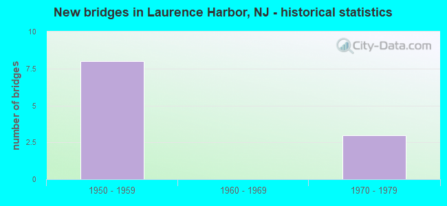
- New bridges - historical statistics
- 81950-1959
- 31970-1979


- Bridge Condition - Deck
- 33.3%Very good
- 16.7%Good
- 33.3%Satisfactory
- 16.7%Fair

- Bridge Condition - Superstructure
- 50.0%Satisfactory
- 50.0%Fair

- Bridge Condition - Substructure
- 33.3%Good
- 50.0%Satisfactory
- 16.7%Fair
Find on map >> Show street view
Structure Number: 1262162, Location: 0.5 MILE WEST OF NJ 35 (Lat: 40.449331, Lng: -74.249350), Route carried "on" structure: County highway 626, Year Built: 1970, Status: Open, Structure Length: 3.66m (12.01ft), Average Daily Traffic: 8,040 (year 2020), Truck Traffic: 3%, Average Future Daily Traffic: 9,648 (year 2040), Design Load: HS 20, Features Intersected: NORTH JERSEY COAST LINE, Facility Carried by Structure: LAURENCE PARKWAY
Minimum Vertical Clearance: 30+ m (98+ ft), Kilometerpoint: 2.543, Lanes on structure: 2, Owner: State Agenciy, Approaching Roadway Width: 7.3m (24.0ft), Skew: 3 degrees, Material/Design: Prestressed concrete, Design/Construction: Box Beam or Girders - Multiple, Number Of Spans In Main Unit: 3, Length of Maximum Span: 14.6m (47.9ft), Curb or Sidewalk Widths: Left: 1.8m (5.9ft), Right: 1.8m (5.9ft), Curb-To-Curb Width: 7.3m (24.0ft), Out-to-Out Width: 11.6m (38.1ft)
Condition: Deck: Fair, Superstructure: Fair, Substructure: Fair, Operating Rating: 37.2 metric tons, Method Used To Determine Operating Rating: Load Factor (LF), Inventory Rating: 21.8 metric tons, Method Used To Determine Inventory Rating: Load Factor (LF), Structural Evaluation: Somewhat better than minimum adequacy, Deck Geometry: High priority of replacement, Underclear: Meets minimum limits, Approach Roadway Alignment: Better than present minimum criteria, Length Of Structure Improvement: 3.66m (12.01ft), Designated Inspection Frequency: Every 24 months, Inspection Date: September 2020, Bridge Improvement Cost: $396,000, Roadway Improvement Cost: $79,000, Total Project Cost: $910,000 ( Estimate for 2020), Deck Structure Type: Concrete Precast Panels, Wearing Surface/Protective System: Wearing Surface: Bituminous
Find on map >> Show street view
Structure Number: 361210S, Location: 2.03MI NW OF GSP&RT35 JCT (Lat: 40.433997, Lng: -74.251197), Route carried "on" structure: County highway 626, Year Built: 1953, Year Reconstructed: 2016, Status: Open, Structure Length: 7.41m (24.31ft), Average Daily Traffic: 7,416 (year 2020), Truck Traffic: 1%, Average Future Daily Traffic: 9,049 (year 2040), Design Load: HS 20, Features Intersected: GSP SBI & SBO
Minimum Vertical Clearance: 30+ m (98+ ft), Kilometerpoint: 0.917, Lanes on structure: 2, Lanes under structure: 6, Owner: State Toll Authority, Approaching Roadway Width: 10.1m (33.1ft), Skew: 3 degrees, Material/Design: Steel, Design/Construction: Stringer/Multi-beam, Number Of Spans In Main Unit: 4, Length of Maximum Span: 26.8m (87.9ft), Curb or Sidewalk Widths: Left: 1.8m (5.9ft), Right: 0.0m, Curb-To-Curb Width: 9.9m (32.5ft), Out-to-Out Width: 12.6m (41.3ft)
Condition: Deck: Very good, Superstructure: Satisfactory, Substructure: Satisfactory, Operating Rating: 67.7 metric tons, Method Used To Determine Operating Rating: Load and Resistance Factor Rating (LRFR) rating reported by rating factor(RF) method using HL-93 loadings, Inventory Rating: 52.2 metric tons, Method Used To Determine Inventory Rating: Load and Resistance Factor Rating (LRFR) rating reported by rating factor(RF) method using HL-93 loadings, Structural Evaluation: Equal to present minimum criteria, Deck Geometry: Meets minimum limits, Underclear: High priority of corrective action, Approach Roadway Alignment: Equal to present desirable criteria, Length Of Structure Improvement: 7.41m (24.31ft), Designated Inspection Frequency: Every 24 months, Inspection Date: September 2020, Bridge Improvement Cost: $3,539,000, Roadway Improvement Cost: $531,000, Total Project Cost: $4,200,000 ( Estimate for 2018), Deck Structure Type: Concrete Cast-file-Place, Wearing Surface/Protective System: Wearing Surface: Monolithic Concrete, Deck Protection: Epoxy Coated Reinforcing
Find on map >> Show street view
Structure Number: 361211N, Location: 3.54MI SE OF GSP&RT9 JCT (Lat: 40.435347, Lng: -74.251181), Route carried "on" structure: County highway 626, Year Built: 1953, Year Reconstructed: 2016, Status: Open, Structure Length: 9.02m (29.59ft), Average Daily Traffic: 7,416 (year 2020), Truck Traffic: 3%, Average Future Daily Traffic: 9,049 (year 2040), Design Load: HS 20, Features Intersected: GSP NBI & NBO
Minimum Vertical Clearance: 30+ m (98+ ft), Kilometerpoint: 0.917, Lanes on structure: 2, Lanes under structure: 6, Owner: State Toll Authority, Approaching Roadway Width: 9.8m (32.2ft), Skew: 3 degrees, Material/Design: Steel, Design/Construction: Stringer/Multi-beam, Number Of Spans In Main Unit: 5, Length of Maximum Span: 20.7m (67.9ft), Curb or Sidewalk Widths: Left: 1.8m (5.9ft), Right: 0.0m, Curb-To-Curb Width: 9.9m (32.5ft), Out-to-Out Width: 12.6m (41.3ft)
Condition: Deck: Very good, Superstructure: Satisfactory, Substructure: Satisfactory, Operating Rating: 67.1 metric tons, Method Used To Determine Operating Rating: Load and Resistance Factor Rating (LRFR) rating reported by rating factor(RF) method using HL-93 loadings, Inventory Rating: 51.8 metric tons, Method Used To Determine Inventory Rating: Load and Resistance Factor Rating (LRFR) rating reported by rating factor(RF) method using HL-93 loadings, Structural Evaluation: Equal to present minimum criteria, Deck Geometry: Meets minimum limits, Underclear: High priority of corrective action, Approach Roadway Alignment: Equal to present desirable criteria, Length Of Structure Improvement: 9.02m (29.59ft), Designated Inspection Frequency: Every 24 months, Inspection Date: August 2020, Bridge Improvement Cost: $4,048,000, Roadway Improvement Cost: $607,000, Total Project Cost: $5,262,000 ( Estimate for 2014), Deck Structure Type: Concrete Cast-file-Place, Wearing Surface/Protective System: Wearing Surface: Monolithic Concrete, Deck Protection: Epoxy Coated Reinforcing
Find on map >> Show street view
Structure Number: 361215E, Location: 3 MI SE OF GSP&RT9 JCT (Lat: 40.439194, Lng: -74.259667), Route carried "on" structure: Other road GSP, Year Built: 1975, Status: Open, Structure Length: 2.59m (8.50ft), Average Daily Traffic: 34,073 (year 2020), Truck Traffic: 1%, Average Future Daily Traffic: 41,569 (year 2040), Design Load: HS 15, Features Intersected: CHEESEQUAKE PARK ROAD
Minimum Vertical Clearance: 30+ m (98+ ft), Kilometerpoint: 195.535, Lanes on structure: 3, Lanes under structure: 2, Base Highway Network: Yes, Toll: On toll road, Owner: State Toll Authority, Approaching Roadway Width: 11.3m (37.1ft), Skew: 2 degrees, Material/Design: Prestressed concrete, Design/Construction: Stringer/Multi-beam, Number Of Spans In Main Unit: 1, Length of Maximum Span: 24.4m (80.1ft), Curb-To-Curb Width: 11.4m (37.4ft), Out-to-Out Width: 12.3m (40.4ft)
Condition: Deck: Satisfactory, Superstructure: Satisfactory, Substructure: Satisfactory, Operating Rating: 44.4 metric tons, Method Used To Determine Operating Rating: Load and Resistance Factor Rating (LRFR) rating reported by rating factor(RF) method using HL-93 loadings, Inventory Rating: 20.1 metric tons, Method Used To Determine Inventory Rating: Load and Resistance Factor Rating (LRFR) rating reported by rating factor(RF) method using HL-93 loadings, Structural Evaluation: Somewhat better than minimum adequacy, Deck Geometry: High priority of replacement, Underclear: High priority of corrective action, Approach Roadway Alignment: Equal to present desirable criteria, Length Of Structure Improvement: 2.59m (8.50ft), Designated Inspection Frequency: Every 24 months, Inspection Date: September 2020, Bridge Improvement Cost: $1,354,000, Roadway Improvement Cost: $135,000, Total Project Cost: $1,787,000 ( Estimate for 2016), Deck Structure Type: Concrete Cast-file-Place, Wearing Surface/Protective System: Wearing Surface: Bituminous, Membrane: Other, Deck Protection: Other
Find on map >> Show street view
Structure Number: 361215U, Location: 3 MI SE OF GSP&RT 9 JCT (Lat: 40.438989, Lng: -74.259544), Route carried "on" structure: Other road GSP, Year Built: 1953, Status: Open, Structure Length: 3.29m (10.79ft), Average Daily Traffic: 62,152 (year 2020), Truck Traffic: 1%, Average Future Daily Traffic: 75,825 (year 2040), Design Load: H 20, Features Intersected: CHEESEQUAKE PARK ROAD
Minimum Vertical Clearance: 30+ m (98+ ft), Kilometerpoint: 195.535, Lanes on structure: 3, Lanes under structure: 2, Base Highway Network: Yes, Toll: On toll road, Owner: State Toll Authority, Approaching Roadway Width: 14.0m (45.9ft), Skew: 2 degrees, Material/Design: Steel, Design/Construction: Stringer/Multi-beam, Number Of Spans In Main Unit: 3, Length of Maximum Span: 12.2m (40.0ft), Curb-To-Curb Width: 14.3m (46.9ft), Out-to-Out Width: 15.2m (49.9ft)
Condition: Deck: Satisfactory, Superstructure: Fair, Substructure: Good, Operating Rating: 56.4 metric tons, Method Used To Determine Operating Rating: Load and Resistance Factor Rating (LRFR) rating reported by rating factor(RF) method using HL-93 loadings, Inventory Rating: 43.4 metric tons, Method Used To Determine Inventory Rating: Load and Resistance Factor Rating (LRFR) rating reported by rating factor(RF) method using HL-93 loadings, Structural Evaluation: Somewhat better than minimum adequacy, Deck Geometry: Meets minimum limits, Underclear: High priority of corrective action, Approach Roadway Alignment: Superior to present desirable criteria, Length Of Structure Improvement: 3.29m (10.79ft), Designated Inspection Frequency: Every 24 months, Inspection Date: September 2020, Bridge Improvement Cost: $2,072,000, Roadway Improvement Cost: $207,000, Total Project Cost: $2,485,000 ( Estimate for 2018), Deck Structure Type: Concrete Cast-file-Place, Wearing Surface/Protective System: Wearing Surface: Bituminous, Membrane: Preformed Fabric
Find on map >> Show street view
Structure Number: 361217O, Location: 3 MI SE OF GSP & RT9 JCT (Lat: 40.438333, Lng: -74.258333), Route carried "on" structure: Other road GSP, Year Built: 1953, Status: Open, Structure Length: 3.26m (10.70ft), Average Daily Traffic: 55,369 (year 2020), Truck Traffic: 1%, Average Future Daily Traffic: 67,550 (year 2040), Design Load: H 20, Features Intersected: CHEESEQUAKE PARK ROAD
Minimum Vertical Clearance: 30+ m (98+ ft), Kilometerpoint: 195.857, Lanes on structure: 3, Lanes under structure: 2, Base Highway Network: Yes, Toll: On toll road, Owner: State Toll Authority, Approaching Roadway Width: 14.0m (45.9ft), Skew: 2 degrees, Material/Design: Steel, Design/Construction: Stringer/Multi-beam, Number Of Spans In Main Unit: 3, Length of Maximum Span: 12.8m (42.0ft), Curb-To-Curb Width: 14.3m (46.9ft), Out-to-Out Width: 15.2m (49.9ft)
Condition: Deck: Good, Superstructure: Fair, Substructure: Good, Operating Rating: 57.3 metric tons, Method Used To Determine Operating Rating: Load and Resistance Factor Rating (LRFR) rating reported by rating factor(RF) method using HL-93 loadings, Inventory Rating: 44.1 metric tons, Method Used To Determine Inventory Rating: Load and Resistance Factor Rating (LRFR) rating reported by rating factor(RF) method using HL-93 loadings, Structural Evaluation: Somewhat better than minimum adequacy, Deck Geometry: Meets minimum limits, Underclear: High priority of corrective action, Approach Roadway Alignment: Superior to present desirable criteria, Length Of Structure Improvement: 3.26m (10.70ft), Designated Inspection Frequency: Every 24 months, Inspection Date: September 2020, Bridge Improvement Cost: $2,013,000, Roadway Improvement Cost: $201,000, Total Project Cost: $2,657,000 ( Estimate for 2016), Deck Structure Type: Concrete Cast-file-Place, Wearing Surface/Protective System: Wearing Surface: Bituminous, Membrane: Other, Deck Protection: Other
Find on map >> Show street view
Structure Number: 361210S, Location: 2.03MI NW OF GSP&RT35 JCT (Lat: 40.433997, Lng: -74.251197), Route carried "under" structure: Other road GSP, Year Built: 1953, Structure Length: 0. m, Average Daily Traffic: 86,611 (year 2020), Truck Traffic: 1%, Features Intersected: GSP SBI & SBO, Facility Carried by Structure: MATAWAN RD(CR626)
Minimum Vertical Clearance: 4.82m (15.81ft), Kilometerpoint: 194.731, Lanes on structure: 2, Lanes under structure: 6, Toll: On toll road, Material/Design: Steel, Design/Construction: Stringer/Multi-beam, Length of Maximum Span: 26.8m (87.9ft)
Find on map >> Show street view
Structure Number: 361211N, Location: 3.54MI SE OF GSP&RT9 JCT (Lat: 40.435347, Lng: -74.251181), Route carried "under" structure: Other road GSP, Year Built: 1953, Structure Length: 0. m, Average Daily Traffic: 85,930 (year 2020), Truck Traffic: 1%, Features Intersected: GSP NBI & NBO, Facility Carried by Structure: MATAWAN RD (CR626)
Minimum Vertical Clearance: 5.05m (16.57ft), Kilometerpoint: 194.892, Lanes on structure: 2, Lanes under structure: 6, Toll: On toll road, Material/Design: Steel, Design/Construction: Stringer/Multi-beam, Length of Maximum Span: 20.7m (67.9ft)
Find on map >> Show street view
Structure Number: 361215E, Location: 3 MI SE OF GSP&RT9 JCT (Lat: 40.439194, Lng: -74.259667), Route carried "under" structure: City street , Year Built: 1975, Structure Length: 0. m, Average Daily Traffic: 742 (year 2020), Features Intersected: CHEESEQUAKE PARK ROAD, Facility Carried by Structure: GSP SBI
Minimum Vertical Clearance: 3.53m (11.58ft), Kilometerpoint: 0.000, Lanes on structure: 3, Lanes under structure: 2, Material/Design: Prestressed concrete, Design/Construction: Stringer/Multi-beam, Length of Maximum Span: 24.4m (80.1ft)
Find on map >> Show street view
Structure Number: 361215U, Location: 3 MI SE OF GSP&RT 9 JCT (Lat: 40.438989, Lng: -74.259544), Route carried "under" structure: City street , Year Built: 1953, Structure Length: 0. m, Average Daily Traffic: 689 (year 2020), Features Intersected: CHEESEQUAKE PARK ROAD, Facility Carried by Structure: GSP SBO
Minimum Vertical Clearance: 3.38m (11.09ft), Kilometerpoint: 0.000, Lanes on structure: 3, Lanes under structure: 2, Material/Design: Steel, Design/Construction: Stringer/Multi-beam, Length of Maximum Span: 12.2m (40.0ft)
Find on map >> Show street view
Structure Number: 361217O, Location: 3 MI SE OF GSP & RT9 JCT (Lat: 40.438333, Lng: -74.258333), Route carried "under" structure: City street , Year Built: 1953, Structure Length: 0. m, Average Daily Traffic: 689 (year 2020), Features Intersected: CHEESEQUAKE PARK ROAD, Facility Carried by Structure: GSP NBO
Minimum Vertical Clearance: 3.73m (12.24ft), Kilometerpoint: 0.000, Lanes on structure: 3, Lanes under structure: 2, Material/Design: Steel, Design/Construction: Stringer/Multi-beam, Length of Maximum Span: 12.8m (42.0ft)