Bridge Statistics for Laurel, Maryland (MD)
Condition, Traffic, Stress, Structural Evaluation, Project Costs
- National Bridge Inventory (NBI) Statistics
- 21Number of bridges
- 289ft / 88.3mTotal length
- $3,132,000Total costs
- 472,088Total average daily traffic
- 22,520Total average daily truck traffic
- National Bridge Inventory (NBI) Registered Bridges for Laurel
- No street view available for this location
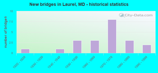
- New bridges - historical statistics
- 11920-1929
- 11940-1949
- 31950-1959
- 31960-1969
- 81970-1979
- 31980-1989
- 21990-1999

- Reconstructed bridges - Historical Statistics
- 31960-1969
- 11970-1979
- 01980-1989
- 01990-1999
- 12000-2009


- Bridge Condition - Deck
- 10.0%Very good
- 30.0%Good
- 30.0%Satisfactory
- 20.0%Fair
- 10.0%Poor

- Bridge Condition - Superstructure
- 50.0%Good
- 30.0%Satisfactory
- 10.0%Fair
- 10.0%Poor

- Bridge Condition - Substructure
- 60.0%Good
- 30.0%Satisfactory
- 10.0%Fair

- Bridge Condition - Channel
- 15.4%Very good
- 69.2%Good
- 7.7%Satisfactory
- 7.7%Fair

- Bridge Condition - Culverts
- 12.5%Good
- 75.0%Satisfactory
- 12.5%Fair
Find on map >> Show street view
Structure Number: 10000013004401, Location: ON PRINCE GEORGES CO LINE (Lat: 39.109514, Lng: -76.853631), Route carried "on" structure: State highway 216, Year Built: 1960, Status: Open, Structure Length: 8.08m (26.51ft), Average Daily Traffic: 24,762 (year 2009), Truck Traffic: 8%, Average Future Daily Traffic: 24,492 (year 2026), Design Load: HS 20, Features Intersected: PATUXENT RIVER
Minimum Vertical Clearance: 30+ m (98+ ft), Kilometerpoint: 0.000, Lanes on structure: 4, Owner: State Highway Agency, Approaching Roadway Width: 25.6m (84.0ft), Skew: 20 degrees, Material/Design: Steel continuous, Design/Construction: Stringer/Multi-beam, Number Of Spans In Main Unit: 3, Length of Maximum Span: 30.5m (100.1ft), Curb or Sidewalk Widths: Left: 1.6m (5.2ft), Right: 1.6m (5.2ft), Curb-To-Curb Width: 21.3m (69.9ft), Out-to-Out Width: 25.1m (82.3ft)
Condition: Deck: Fair, Superstructure: Good, Substructure: Satisfactory, Channel: Very good, Operating Rating: 76.2 metric tons, Method Used To Determine Operating Rating: Load Factor (LF), Inventory Rating: 45.4 metric tons, Method Used To Determine Inventory Rating: Load Factor (LF), Structural Evaluation: Equal to present minimum criteria, Deck Geometry: Superior to present desirable criteria, Waterway Adequacy: Superior to present desirable criteria, Approach Roadway Alignment: Equal to present desirable criteria, Designated Inspection Frequency: Every 24 months, Inspection Date: September 2020, Deck Structure Type: Concrete Cast-file-Place, Wearing Surface/Protective System: Wearing Surface: Bituminous
Find on map >> Show street view
Structure Number: 10000016000101, Location: ON HOWARD CO LINE (Lat: 39.104575, Lng: -76.841403), Route carried "on" structure: US 1, Year Built: 1949, Year Reconstructed: 2006, Status: Open, Structure Length: 6.71m (22.01ft), Average Daily Traffic: 16,182 (year 2009), Truck Traffic: 7%, Average Future Daily Traffic: 9,230 (year 2026), Design Load: HS 25 or greater, Features Intersected: PATUXENT RIVER
Minimum Vertical Clearance: 30+ m (98+ ft), Kilometerpoint: 22.719, Lanes on structure: 2, Base Highway Network: Yes, Owner: State Highway Agency, Approaching Roadway Width: 10.1m (33.1ft), Skew: 2 degrees, Material/Design: Steel continuous, Design/Construction: Stringer/Multi-beam, Number Of Spans In Main Unit: 3, Length of Maximum Span: 25.9m (85.0ft), Curb or Sidewalk Widths: Left: 1.6m (5.2ft), Right: 1.6m (5.2ft), Curb-To-Curb Width: 9.8m (32.2ft), Out-to-Out Width: 13.6m (44.6ft)
Condition: Deck: Very good, Superstructure: Good, Substructure: Good, Channel: Very good, Operating Rating: 48.5 metric tons, Method Used To Determine Operating Rating: Load Factor (LF), Inventory Rating: 29.0 metric tons, Method Used To Determine Inventory Rating: Load Factor (LF), Structural Evaluation: Better than present minimum criteria, Deck Geometry: Meets minimum limits, Waterway Adequacy: Superior to present desirable criteria, Approach Roadway Alignment: Equal to present desirable criteria, Designated Inspection Frequency: Every 24 months, Inspection Date: September 2020, Deck Structure Type: Concrete Cast-file-Place, Wearing Surface/Protective System: Wearing Surface: Bituminous
Find on map >> Show street view
Structure Number: 100000160078013, Location: ON ANNE ARUNDEL CO LINE (Lat: 39.096036, Lng: -76.836850), Route carried "on" structure: State highway 198, Year Built: 1986, Status: Open, Structure Length: 21.49m (70.51ft), Average Daily Traffic: 20,487 (year 2012), Truck Traffic: 8%, Average Future Daily Traffic: 27,657 (year 2032), Design Load: HS 20, Features Intersected: PATUXENT RIVER
Minimum Vertical Clearance: 30+ m (98+ ft), Kilometerpoint: 6.804, Lanes on structure: 3, Base Highway Network: Yes, Owner: State Highway Agency, Approaching Roadway Width: 13.1m (43.0ft), Skew: 3 degrees, Material/Design: Steel continuous, Design/Construction: Stringer/Multi-beam, Number Of Spans In Main Unit: 6, Length of Maximum Span: 42.7m (140.1ft), Curb or Sidewalk Widths: Left: 0.0m, Right: 1.5m (4.9ft), Curb-To-Curb Width: 13.1m (43.0ft), Out-to-Out Width: 15.4m (50.5ft)
Condition: Deck: Good, Superstructure: Good, Substructure: Good, Channel: Good, Operating Rating: 63.9 metric tons, Method Used To Determine Operating Rating: Load Factor (LF), Inventory Rating: 38.5 metric tons, Method Used To Determine Inventory Rating: Load Factor (LF), Structural Evaluation: Better than present minimum criteria, Deck Geometry: Meets minimum limits, Waterway Adequacy: Superior to present desirable criteria, Approach Roadway Alignment: Equal to present desirable criteria, Length Of Structure Improvement: 21.49m (70.51ft), Designated Inspection Frequency: Every 24 months, Inspection Date: April 2021, Bridge Improvement Cost: $2,140,000, Roadway Improvement Cost: $214,000, Total Project Cost: $2,354,000, Deck Structure Type: Concrete Cast-file-Place, Wearing Surface/Protective System: Wearing Surface: Monolithic Concrete, Deck Protection: Epoxy Coated Reinforcing
Find on map >> Show street view
Structure Number: 100000160200014, Location: 1.85 MILES WEST OF MD 216 (Lat: 39.100131, Lng: -76.888825), Route carried "on" structure: State highway 198, Year Built: 1971, Year Reconstructed: 1973, Status: Open, Structure Length: 14.02m (46.00ft), Average Daily Traffic: 49,801 (year 2009), Truck Traffic: 8%, Average Future Daily Traffic: 16,073 (year 2026), Design Load: HS 20, Features Intersected: IS 95
Minimum Vertical Clearance: 30+ m (98+ ft), Kilometerpoint: 1.844, Lanes on structure: 2, Lanes under structure: 8, Base Highway Network: Yes, Owner: State Highway Agency, Approaching Roadway Width: 11.6m (38.1ft), Skew: 2 degrees, Material/Design: Steel continuous, Design/Construction: Stringer/Multi-beam, Number Of Spans In Main Unit: 3, Number Of Approach Spans: 1, Length of Maximum Span: 47.9m (157.2ft), Curb-To-Curb Width: 15.7m (51.5ft), Out-to-Out Width: 16.6m (54.5ft)
Condition: Deck: Satisfactory, Superstructure: Satisfactory, Substructure: Satisfactory, Operating Rating: 68.5 metric tons, Method Used To Determine Operating Rating: Load Factor (LF), Inventory Rating: 40.8 metric tons, Method Used To Determine Inventory Rating: Load Factor (LF), Structural Evaluation: Equal to present minimum criteria, Deck Geometry: Superior to present desirable criteria, Underclear: Somewhat better than minimum adequacy, Approach Roadway Alignment: Equal to present desirable criteria, Designated Inspection Frequency: Every 24 months, Inspection Date: November 2021, Deck Structure Type: Concrete Cast-file-Place, Wearing Surface/Protective System: Wearing Surface: Monolithic Concrete
Find on map >> Show street view
Structure Number: 100000160201014, Location: 1.59 MILES WEST OF MD 216 (Lat: 39.100944, Lng: -76.884111), Route carried "on" structure: State highway 198, Year Built: 1971, Year Reconstructed: 1973, Status: Open, Structure Length: 8.75m (28.71ft), Average Daily Traffic: 49,801 (year 2009), Truck Traffic: 8%, Average Future Daily Traffic: 16,073 (year 2026), Design Load: HS 20, Features Intersected: IS 95 RAMP 'B'
Minimum Vertical Clearance: 30+ m (98+ ft), Kilometerpoint: 2.311, Lanes on structure: 2, Lanes under structure: 2, Base Highway Network: Yes, Owner: State Highway Agency, Approaching Roadway Width: 11.6m (38.1ft), Skew: 5 degrees, Material/Design: Steel continuous, Design/Construction: Stringer/Multi-beam, Number Of Spans In Main Unit: 3, Length of Maximum Span: 36.6m (120.1ft), Curb-To-Curb Width: 12.0m (39.4ft), Out-to-Out Width: 13.0m (42.7ft)
Condition: Deck: Satisfactory, Superstructure: Good, Substructure: Satisfactory, Operating Rating: 57.6 metric tons, Method Used To Determine Operating Rating: Load Factor (LF), Inventory Rating: 34.5 metric tons, Method Used To Determine Inventory Rating: Load Factor (LF), Structural Evaluation: Equal to present minimum criteria, Deck Geometry: Better than present minimum criteria, Underclear: Somewhat better than minimum adequacy, Approach Roadway Alignment: Equal to present desirable criteria, Designated Inspection Frequency: Every 24 months, Inspection Date: July 2021, Deck Structure Type: Concrete Cast-file-Place, Wearing Surface/Protective System: Wearing Surface: Monolithic Concrete
Find on map >> Show street view
Structure Number: 200000P-010102, Location: 0.5 MI EAST OF I-95 (Lat: 39.108750, Lng: -76.865653), Route carried "on" structure: County highway 3, Year Built: 1953, Status: Open, Structure Length: 0.91m (2.99ft), Average Daily Traffic: 3,173 (year 2021), Truck Traffic: 5%, Average Future Daily Traffic: 4,210 (year 2041), Design Load: HS 20, Features Intersected: WALKER BRANCH, Facility Carried by Structure: BROOKLYN BRIDGE RO
Minimum Vertical Clearance: 30+ m (98+ ft), Kilometerpoint: 2.011, Lanes on structure: 2, Owner: County Highway Agency, Approaching Roadway Width: 7.6m (24.9ft), Skew: 3 degrees, Material/Design: Concrete, Design/Construction: Culvert, Number Of Spans In Main Unit: 2, Length of Maximum Span: 4.9m (16.1ft)
Condition: Channel: Fair, Culverts: Satisfactory, Structural Evaluation: Equal to present minimum criteria, Waterway Adequacy: Equal to present minimum criteria, Approach Roadway Alignment: Equal to present desirable criteria, Designated Inspection Frequency: Every 24 months, Inspection Date: June 2021
Find on map >> Show street view
Structure Number: 200000P-016001, Location: 0.2 MI EAST OF US 1 NB (Lat: 39.095317, Lng: -76.847742), Route carried "on" structure: County highway 55, Year Built: 1927, Year Reconstructed: 1972, Status: Posted for load, Structure Length: 2.07m (6.79ft), Average Daily Traffic: 13,870 (year 2017), Truck Traffic: 10%, Average Future Daily Traffic: 16,930 (year 2037), Features Intersected: TRIB TO PATUXENT RIVER, Facility Carried by Structure: BOWIE ROAD
Minimum Vertical Clearance: 30+ m (98+ ft), Kilometerpoint: 0.000, Lanes on structure: 2, Owner: County Highway Agency, Approaching Roadway Width: 6.4m (21.0ft), Skew: 7 degrees, Material/Design: Concrete, Design/Construction: Slab, Number Of Spans In Main Unit: 1, Length of Maximum Span: 20.7m (67.9ft), Curb-To-Curb Width: 6.2m (20.3ft), Out-to-Out Width: 6.2m (20.3ft)
Condition: Deck: Poor, Superstructure: Poor, Substructure: Fair, Channel: Good, Operating Rating: 51.2 metric tons, Method Used To Determine Operating Rating: Load Factor (LF), Inventory Rating: 30.8 metric tons, Method Used To Determine Inventory Rating: Load Factor (LF), Structural Evaluation: Meets minimum limits, Deck Geometry: High priority of replacement, Waterway Adequacy: Equal to present desirable criteria, Approach Roadway Alignment: Equal to present minimum criteria, Length Of Structure Improvement: 2.07m (6.79ft), Designated Inspection Frequency: Every 24 months, Inspection Date: March 2021, Bridge Improvement Cost: $87,000, Roadway Improvement Cost: $9,000, Total Project Cost: $96,000, Deck Structure Type: Concrete Cast-file-Place, Wearing Surface/Protective System: Wearing Surface: Bituminous
Find on map >> Show street view
Structure Number: 200000P-016102, Location: 0.2 MI EAST OF US 1 NB (Lat: 39.095167, Lng: -76.847789), Route carried "on" structure: County highway 55, Year Built: 1972, Status: Posted for load, Structure Length: 2.13m (6.99ft), Average Daily Traffic: 13,740 (year 2017), Truck Traffic: 10%, Average Future Daily Traffic: 20,410 (year 2037), Design Load: HS 20, Features Intersected: BEAR BRANCH, Facility Carried by Structure: BOWIE ROAD
Minimum Vertical Clearance: 30+ m (98+ ft), Kilometerpoint: 0.000, Lanes on structure: 2, Owner: County Highway Agency, Approaching Roadway Width: 6.4m (21.0ft), Skew: 4 degrees, Material/Design: Concrete, Design/Construction: Culvert, Length of Maximum Span: 6.7m (22.0ft)
Condition: Channel: Good, Culverts: Fair, Operating Rating: 61.7 metric tons, Method Used To Determine Operating Rating: Load Factor (LF), Inventory Rating: 35.8 metric tons, Method Used To Determine Inventory Rating: Load Factor (LF), Structural Evaluation: Somewhat better than minimum adequacy, Waterway Adequacy: Equal to present minimum criteria, Approach Roadway Alignment: Equal to present minimum criteria, Length Of Structure Improvement: 6.22m (20.41ft), Designated Inspection Frequency: Every 24 months, Inspection Date: March 2021, Bridge Improvement Cost: $102,000, Roadway Improvement Cost: $10,000, Total Project Cost: $112,000
Find on map >> Show street view
Structure Number: 200000P-016802, Location: 250 FT S OF ASHFORD BLVD (Lat: 39.090153, Lng: -76.866061), Route carried "on" structure: County highway 295, Year Built: 1985, Status: Open, Structure Length: 1.22m (4.00ft), Average Daily Traffic: 1,687 (year 2017), Truck Traffic: 2%, Average Future Daily Traffic: 2,520 (year 2037), Design Load: HS 20, Features Intersected: BEAR BRANCH, Facility Carried by Structure: OXFORD DRIVE
Minimum Vertical Clearance: 30+ m (98+ ft), Kilometerpoint: 0.000, Lanes on structure: 2, Owner: County Highway Agency, Approaching Roadway Width: 11.0m (36.1ft), Material/Design: Concrete, Design/Construction: Culvert, Number Of Spans In Main Unit: 3, Length of Maximum Span: 4.0m (13.1ft), Curb or Sidewalk Widths: Left: 1.2m (3.9ft), Right: 1.2m (3.9ft)
Condition: Channel: Good, Culverts: Satisfactory, Operating Rating: 71.2 metric tons, Method Used To Determine Operating Rating: Load Factor (LF), Inventory Rating: 42.6 metric tons, Method Used To Determine Inventory Rating: Load Factor (LF), Structural Evaluation: Equal to present minimum criteria, Waterway Adequacy: Better than present minimum criteria, Approach Roadway Alignment: Equal to present desirable criteria, Designated Inspection Frequency: Every 24 months, Inspection Date: Febuary 2021
Find on map >> Show street view
Structure Number: 200000P-016901, Location: 0.1 MI EAST OF US 1 (Lat: 39.087047, Lng: -76.852333), Route carried "on" structure: County highway 6, Year Built: 1997, Status: Open, Structure Length: 5.33m (17.49ft), Average Daily Traffic: 22,202 (year 2019), Truck Traffic: 5%, Average Future Daily Traffic: 33,000 (year 2039), Design Load: HS 25 or greater, Features Intersected: CSX RAILROAD, Facility Carried by Structure: CONTEE ROAD
Minimum Vertical Clearance: 30+ m (98+ ft), Kilometerpoint: 0.000, Lanes on structure: 4, Owner: County Highway Agency, Approaching Roadway Width: 15.9m (52.2ft), Skew: 2 degrees, Material/Design: Steel continuous, Design/Construction: Stringer/Multi-beam, Number Of Spans In Main Unit: 3, Length of Maximum Span: 22.9m (75.1ft), Curb or Sidewalk Widths: Left: 1.5m (4.9ft), Right: 1.5m (4.9ft), Curb-To-Curb Width: 15.9m (52.2ft), Out-to-Out Width: 19.5m (64.0ft)
Condition: Deck: Good, Superstructure: Good, Substructure: Good, Operating Rating: 82.1 metric tons, Method Used To Determine Operating Rating: Load Factor (LF), Inventory Rating: 49.4 metric tons, Method Used To Determine Inventory Rating: Load Factor (LF), Structural Evaluation: Better than present minimum criteria, Deck Geometry: Meets minimum limits, Underclear: Better than present minimum criteria, Approach Roadway Alignment: Equal to present minimum criteria, Length Of Structure Improvement: 5.49m (18.01ft), Designated Inspection Frequency: Every 24 months, Inspection Date: October 2021, Bridge Improvement Cost: $5,000, Roadway Improvement Cost: $3,000, Total Project Cost: $8,000, Deck Structure Type: Concrete Cast-file-Place, Wearing Surface/Protective System: Deck Protection: Epoxy Coated Reinforcing
Find on map >> Show street view
Structure Number: 200000P-019604, Location: 0.06 MI E OF US 1 (Lat: 39.091100, Lng: -76.856525), Route carried "on" structure: County highway 7, Year Built: 1967, Year Reconstructed: 1976, Status: Posted for load, Structure Length: 1.04m (3.41ft), Average Daily Traffic: 19,770 (year 2017), Truck Traffic: 10%, Average Future Daily Traffic: 29,370 (year 2037), Design Load: HS 20, Features Intersected: BEAR BRANCH, Facility Carried by Structure: CHERRY LANE
Minimum Vertical Clearance: 30+ m (98+ ft), Kilometerpoint: 2.558, Lanes on structure: 6, Owner: County Highway Agency, Approaching Roadway Width: 29.3m (96.1ft), Skew: 21 degrees, Material/Design: Concrete continuous, Design/Construction: Frame, Number Of Spans In Main Unit: 2, Length of Maximum Span: 4.6m (15.1ft), Curb or Sidewalk Widths: Left: 1.7m (5.6ft), Right: 2.2m (7.2ft), Curb-To-Curb Width: 26.2m (86.0ft), Out-to-Out Width: 33.4m (109.6ft)
Condition: Deck: Fair, Superstructure: Fair, Substructure: Good, Channel: Satisfactory, Operating Rating: 55.3 metric tons, Method Used To Determine Operating Rating: Load Factor (LF), Inventory Rating: 32.7 metric tons, Method Used To Determine Inventory Rating: Load Factor (LF), Structural Evaluation: Somewhat better than minimum adequacy, Deck Geometry: Equal to present minimum criteria, Waterway Adequacy: Somewhat better than minimum adequacy, Approach Roadway Alignment: Equal to present desirable criteria, Designated Inspection Frequency: Every 24 months, Inspection Date: March 2021, Wearing Surface/Protective System: Wearing Surface: Bituminous
Find on map >> Show street view
Structure Number: 200000P-019702, Location: 0.17 MI E OF US 1 (Lat: 39.095633, Lng: -76.848339), Route carried "on" structure: County highway 2310, Year Built: 1962, Status: Posted for load, Structure Length: 1.16m (3.81ft), Average Daily Traffic: 14,613 (year 2017), Truck Traffic: 10%, Average Future Daily Traffic: 21,830 (year 2037), Design Load: HS 20, Features Intersected: TRIB. TO PATUXENT RIVER, Facility Carried by Structure: MARSHALL AVENUE
Minimum Vertical Clearance: 30+ m (98+ ft), Kilometerpoint: 0.274, Lanes on structure: 2, Owner: County Highway Agency, Approaching Roadway Width: 14.3m (46.9ft), Material/Design: Concrete, Design/Construction: Culvert, Length of Maximum Span: 5.8m (19.0ft), Curb or Sidewalk Widths: Left: 1.8m (5.9ft), Right: 1.8m (5.9ft), Curb-To-Curb Width: 11.0m (36.1ft), Out-to-Out Width: 15.2m (49.9ft)
Condition: Channel: Good, Culverts: Satisfactory, Operating Rating: 24.9 metric tons, Method Used To Determine Operating Rating: Load Factor (LF), Inventory Rating: 15.0 metric tons, Method Used To Determine Inventory Rating: Load Factor (LF), Structural Evaluation: High priority of corrective action, Deck Geometry: Meets minimum limits, Waterway Adequacy: Better than present minimum criteria, Approach Roadway Alignment: Equal to present minimum criteria, Bridge Posting: Required (Relationship of Operating Rating to Maximum Legal Load: 20.0 - 29.9% below), Designated Inspection Frequency: Every 12 months, Inspection Date: Febuary 2021
Find on map >> Show street view
Structure Number: 200000P-0198013, Location: 0.66 MI W OF MD 197 (Lat: 39.086889, Lng: -76.852419), Route carried "on" structure: County highway 7, Year Built: 1990, Status: Open, Structure Length: 6.04m (19.82ft), Average Daily Traffic: 10,861 (year 2019), Truck Traffic: 10%, Average Future Daily Traffic: 16,140 (year 2039), Design Load: HS 20+Mod, Features Intersected: CSX RAILROAD, Facility Carried by Structure: CHERRY LANE (EAST)
Minimum Vertical Clearance: 30+ m (98+ ft), Kilometerpoint: 2.558, Lanes on structure: 3, Owner: County Highway Agency, Approaching Roadway Width: 11.0m (36.1ft), Skew: 1 degrees, Material/Design: Steel continuous, Design/Construction: Stringer/Multi-beam, Number Of Spans In Main Unit: 3, Length of Maximum Span: 25.3m (83.0ft), Curb or Sidewalk Widths: Left: 1.5m (4.9ft), Right: 0.0m, Curb-To-Curb Width: 11.0m (36.1ft), Out-to-Out Width: 13.3m (43.6ft)
Condition: Deck: Satisfactory, Superstructure: Satisfactory, Substructure: Good, Operating Rating: 56.2 metric tons, Method Used To Determine Operating Rating: Load Factor (LF), Inventory Rating: 33.6 metric tons, Method Used To Determine Inventory Rating: Load Factor (LF), Structural Evaluation: Equal to present minimum criteria, Deck Geometry: High priority of replacement, Underclear: Equal to present desirable criteria, Approach Roadway Alignment: Equal to present minimum criteria, Length Of Structure Improvement: 6.04m (19.82ft), Designated Inspection Frequency: Every 24 months, Inspection Date: October 2021, Bridge Improvement Cost: $255,000, Roadway Improvement Cost: $26,000, Total Project Cost: $281,000, Deck Structure Type: Concrete Cast-file-Place, Wearing Surface/Protective System: Wearing Surface: Integral Concrete
Find on map >> Show street view
Structure Number: 200000P-0198014, Location: 0.66 MILES WEST OF MD 197 (Lat: 39.087044, Lng: -76.852331), Route carried "on" structure: County highway 7, Year Built: 1979, Status: Open, Structure Length: 6.04m (19.82ft), Average Daily Traffic: 10,860 (year 2019), Truck Traffic: 10%, Average Future Daily Traffic: 16,140 (year 2039), Design Load: HS 20+Mod, Features Intersected: CSX RAILROAD, Facility Carried by Structure: CHERRY LANE (WEST)
Minimum Vertical Clearance: 30+ m (98+ ft), Kilometerpoint: 2.558, Lanes on structure: 3, Owner: County Highway Agency, Approaching Roadway Width: 11.0m (36.1ft), Skew: 1 degrees, Material/Design: Steel continuous, Design/Construction: Stringer/Multi-beam, Number Of Spans In Main Unit: 3, Length of Maximum Span: 25.3m (83.0ft), Curb or Sidewalk Widths: Left: 1.5m (4.9ft), Right: 0.0m, Curb-To-Curb Width: 11.0m (36.1ft), Out-to-Out Width: 13.3m (43.6ft)
Condition: Deck: Good, Superstructure: Satisfactory, Substructure: Good, Operating Rating: 56.2 metric tons, Method Used To Determine Operating Rating: Load Factor (LF), Inventory Rating: 33.6 metric tons, Method Used To Determine Inventory Rating: Load Factor (LF), Structural Evaluation: Equal to present minimum criteria, Deck Geometry: High priority of replacement, Underclear: Equal to present desirable criteria, Approach Roadway Alignment: Equal to present minimum criteria, Length Of Structure Improvement: 6.04m (19.82ft), Designated Inspection Frequency: Every 24 months, Inspection Date: October 2021, Bridge Improvement Cost: $255,000, Roadway Improvement Cost: $26,000, Total Project Cost: $281,000, Deck Structure Type: Concrete Cast-file-Place, Wearing Surface/Protective System: Wearing Surface: Integral Concrete
Find on map >> Show street view
Structure Number: 200000P-055503, Location: 0.5 M EAST OF MD 193 (Lat: 38.908525, Lng: -76.791133), Route carried "on" structure: County highway 5255, Year Built: 1980, Status: Open, Structure Length: 0.94m (3.08ft), Average Daily Traffic: 2,400 (year 2015), Truck Traffic: 3%, Average Future Daily Traffic: 3,566 (year 2035), Features Intersected: NORTHEAST BRANCH, Facility Carried by Structure: KINGS MANOR DRIVE
Minimum Vertical Clearance: 30+ m (98+ ft), Kilometerpoint: 0.000, Lanes on structure: 2, Owner: County Highway Agency, Approaching Roadway Width: 11.0m (36.1ft), Material/Design: Steel, Design/Construction: Culvert, Length of Maximum Span: 4.3m (14.1ft), Curb or Sidewalk Widths: Left: 1.2m (3.9ft), Right: 1.2m (3.9ft)
Condition: Channel: Good, Culverts: Good, Structural Evaluation: Better than present minimum criteria, Waterway Adequacy: Better than present minimum criteria, Approach Roadway Alignment: Equal to present desirable criteria, Designated Inspection Frequency: Every 24 months, Inspection Date: July 2021
Find on map >> Show street view
Structure Number: 200000P-LA0103, Location: 0.06 M S OF BROOKLYN B RD (Lat: 39.110028, Lng: -76.873764), Route carried "on" structure: City street 146, Year Built: 1973, Status: Open, Structure Length: 1.04m (3.41ft), Average Daily Traffic: 633 (year 2019), Truck Traffic: 2%, Average Future Daily Traffic: 940 (year 2039), Design Load: HS 20, Features Intersected: TRIB TO PATUXENT RIVER, Facility Carried by Structure: DORSET ROAD
Minimum Vertical Clearance: 30+ m (98+ ft), Kilometerpoint: 0.097, Lanes on structure: 2, Owner: City or Municipal Highway Agency, Approaching Roadway Width: 11.0m (36.1ft), Skew: 3 degrees, Material/Design: Steel, Design/Construction: Culvert, Length of Maximum Span: 4.6m (15.1ft), Curb or Sidewalk Widths: Left: 1.2m (3.9ft), Right: 1.2m (3.9ft)
Condition: Channel: Good, Culverts: Satisfactory, Structural Evaluation: Equal to present minimum criteria, Waterway Adequacy: Better than present minimum criteria, Approach Roadway Alignment: Equal to present desirable criteria, Designated Inspection Frequency: Every 24 months, Inspection Date: Febuary 2021
Find on map >> Show street view
Structure Number: 200000P-LA0403, Location: 0.1 MI SOUTH OF MD 198 EB (Lat: 39.098900, Lng: -76.854372), Route carried "on" structure: City street 9040, Year Built: 1950, Status: Open, Structure Length: 0.61m (2.00ft), Average Daily Traffic: 1,160 (year 2017), Truck Traffic: 2%, Average Future Daily Traffic: 1,710 (year 2037), Features Intersected: TRIB TO PATUXENT RIVER, Facility Carried by Structure: 4TH STREET
Minimum Vertical Clearance: 30+ m (98+ ft), Kilometerpoint: 0.000, Lanes on structure: 2, Owner: City or Municipal Highway Agency, Approaching Roadway Width: 9.1m (29.9ft), Skew: 1 degrees, Material/Design: Steel, Design/Construction: Culvert, Number Of Spans In Main Unit: 1, Length of Maximum Span: 6.1m (20.0ft), Curb or Sidewalk Widths: Left: 3.0m (9.8ft), Right: 3.0m (9.8ft), Curb-To-Curb Width: 9.2m (30.2ft), Out-to-Out Width: 16.5m (54.1ft)
Condition: Channel: Good, Culverts: Satisfactory, Operating Rating: 62.1 metric tons, Method Used To Determine Operating Rating: Load Factor (LF), Inventory Rating: 37.2 metric tons, Method Used To Determine Inventory Rating: Load Factor (LF), Structural Evaluation: Equal to present minimum criteria, Deck Geometry: Somewhat better than minimum adequacy, Waterway Adequacy: Equal to present desirable criteria, Approach Roadway Alignment: Equal to present desirable criteria, Designated Inspection Frequency: Every 24 months, Inspection Date: March 2021
Find on map >> Show street view
Structure Number: 200000P-LA0503, Location: 0.2 MI SOUTH OF MD 198 EB (Lat: 39.099414, Lng: -76.856208), Route carried "on" structure: City street 9050, Year Built: 1950, Status: Open, Structure Length: 0.70m (2.30ft), Average Daily Traffic: 1,160 (year 2017), Truck Traffic: 2%, Average Future Daily Traffic: 1,710 (year 2037), Features Intersected: TRIB TO PATUXENT RIVER, Facility Carried by Structure: 5TH STREET
Minimum Vertical Clearance: 30+ m (98+ ft), Kilometerpoint: 0.000, Lanes on structure: 2, Owner: City or Municipal Highway Agency, Approaching Roadway Width: 11.0m (36.1ft), Skew: 3 degrees, Material/Design: Steel, Design/Construction: Culvert, Number Of Spans In Main Unit: 1, Length of Maximum Span: 7.0m (23.0ft), Curb or Sidewalk Widths: Left: 3.3m (10.8ft), Right: 3.3m (10.8ft), Curb-To-Curb Width: 9.7m (31.8ft), Out-to-Out Width: 15.9m (52.2ft)
Condition: Channel: Good, Culverts: Satisfactory, Operating Rating: 72.6 metric tons, Method Used To Determine Operating Rating: Load Factor (LF), Inventory Rating: 43.5 metric tons, Method Used To Determine Inventory Rating: Load Factor (LF), Structural Evaluation: Equal to present minimum criteria, Deck Geometry: Somewhat better than minimum adequacy, Waterway Adequacy: Equal to present desirable criteria, Approach Roadway Alignment: Equal to present desirable criteria, Designated Inspection Frequency: Every 24 months, Inspection Date: March 2021
Find on map >> Show street view
Structure Number: 100000160200014, Location: 1.4 M S OF HOWARD CO LINE (Lat: 39.100053, Lng: -76.888839), Route carried "under" structure: Interstate 95, Year Built: 1971, Structure Length: 0. m, Average Daily Traffic: 186,040 (year 2009), Features Intersected: IS 95, Facility Carried by Structure: MD 198 WBR
Minimum Vertical Clearance: 4.88m (16.01ft), Kilometerpoint: 52.614, Lanes on structure: 2, Lanes under structure: 8, Material/Design: Steel continuous, Design/Construction: Stringer/Multi-beam, Length of Maximum Span: 47.9m (157.2ft)
Find on map >> Show street view
Structure Number: 100000160201013, Location: 1.59 MI W OF MD 216 (Lat: 39.100419, Lng: -76.885494), Route carried "under" structure: Ramp Interstate 95, Year Built: 1971, Structure Length: 0. m, Average Daily Traffic: 4,443 (year 2007), Features Intersected: IS 95 RAMP B(7), Facility Carried by Structure: MD 198 EBR
Minimum Vertical Clearance: 4.88m (16.01ft), Kilometerpoint: 52.614, Lanes on structure: 2, Lanes under structure: 2, Material/Design: Steel continuous, Design/Construction: Stringer/Multi-beam, Length of Maximum Span: 31.7m (104.0ft)
Find on map >> Show street view
Structure Number: 100000160201014, Location: 1.59 MI W OF MD 216 (Lat: 39.100847, Lng: -76.884233), Route carried "under" structure: Ramp Interstate 95, Year Built: 1971, Structure Length: 0. m, Average Daily Traffic: 4,443 (year 2007), Features Intersected: IS 95 RAMP 'B', Facility Carried by Structure: MD 198 WBR
Minimum Vertical Clearance: 4.88m (16.01ft), Kilometerpoint: 52.614, Lanes on structure: 2, Lanes under structure: 2, Material/Design: Steel continuous, Design/Construction: Stringer/Multi-beam, Length of Maximum Span: 36.6m (120.1ft)