Bridge Statistics for Lanett, Alabama (AL)
Condition, Traffic, Stress, Structural Evaluation, Project Costs
- National Bridge Inventory (NBI) Statistics
- 21Number of bridges
- 292ft / 89.1mTotal length
- $22,725,000Total costs
- 198,408Total average daily traffic
- 30,658Total average daily truck traffic
- National Bridge Inventory (NBI) Registered Bridges for Lanett
- No street view available for this location
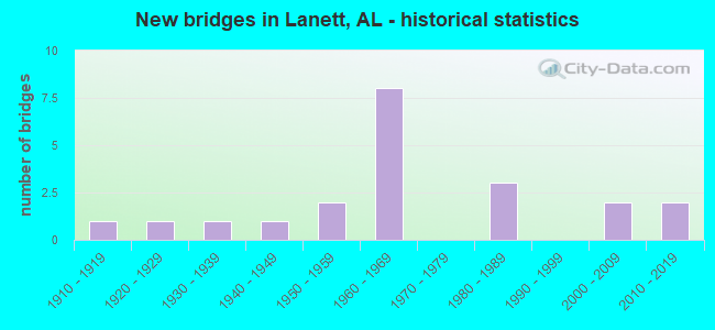
- New bridges - historical statistics
- 11910-1919
- 11920-1929
- 11930-1939
- 11940-1949
- 21950-1959
- 81960-1969
- 31980-1989
- 22000-2009
- 22010-2019
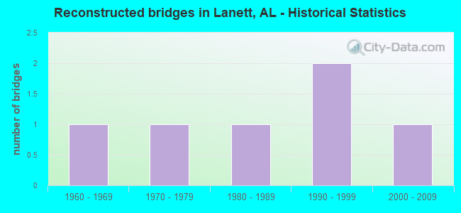
- Reconstructed bridges - Historical Statistics
- 11960-1969
- 11970-1979
- 11980-1989
- 21990-1999
- 12000-2009
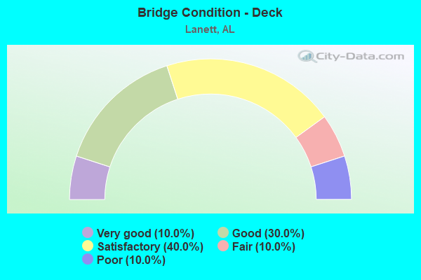
- Bridge Condition - Deck
- 10.0%Very good
- 30.0%Good
- 40.0%Satisfactory
- 10.0%Fair
- 10.0%Poor
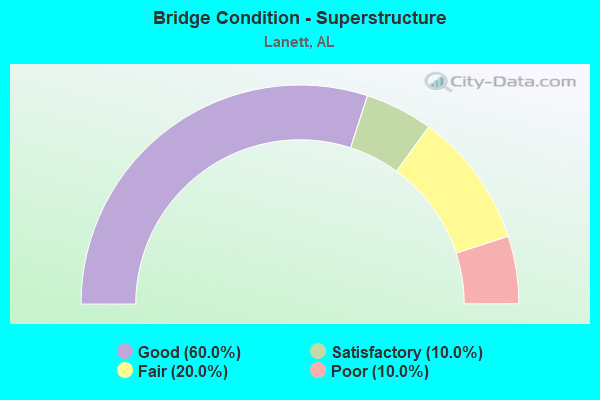
- Bridge Condition - Superstructure
- 60.0%Good
- 10.0%Satisfactory
- 20.0%Fair
- 10.0%Poor
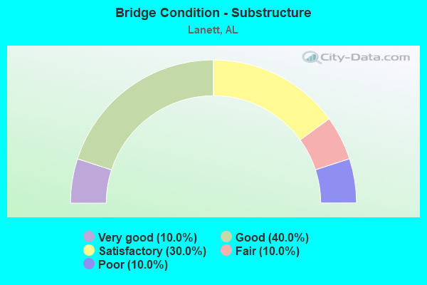
- Bridge Condition - Substructure
- 10.0%Very good
- 40.0%Good
- 30.0%Satisfactory
- 10.0%Fair
- 10.0%Poor
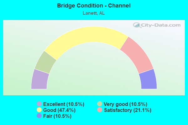
- Bridge Condition - Channel
- 10.5%Excellent
- 10.5%Very good
- 47.4%Good
- 21.1%Satisfactory
- 10.5%Fair
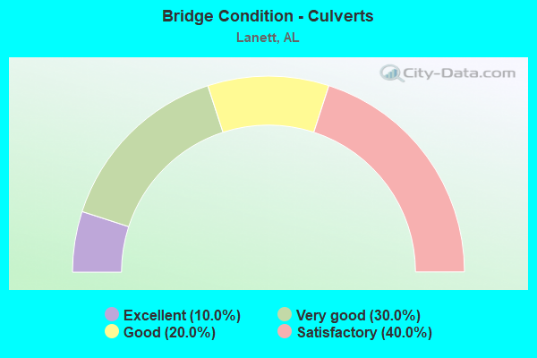
- Bridge Condition - Culverts
- 10.0%Excellent
- 30.0%Very good
- 20.0%Good
- 40.0%Satisfactory
Find on map >> Show street view
Structure Number: 85, Location: 0.9 MI W CR 85 (Lat: 32.160675, Lng: -86.974833), Route carried "on" structure: County highway 438, Year Built: 1915, Year Reconstructed: 1996, Status: Posted for load, Structure Length: 1.86m (6.10ft), Average Daily Traffic: 25 (year 2012), Average Future Daily Traffic: 40 (year 2040), Design Load: H 10, Features Intersected: TRIB TO CEDAR CREEK
Minimum Vertical Clearance: 30+ m (98+ ft), Kilometerpoint: 0.010, Lanes on structure: 1, Owner: County Highway Agency, Approaching Roadway Width: 6.1m (20.0ft), Material/Design: Steel continuous, Design/Construction: Stringer/Multi-beam, Number Of Spans In Main Unit: 8, Length of Maximum Span: 4.0m (13.1ft), Curb-To-Curb Width: 5.0m (16.4ft), Out-to-Out Width: 5.0m (16.4ft)
Condition: Deck: Poor, Superstructure: Poor, Substructure: Poor, Channel: Fair, Operating Rating: 7.3 metric tons, Method Used To Determine Operating Rating: Load Factor (LF), Inventory Rating: 5.4 metric tons, Method Used To Determine Inventory Rating: Load Factor (LF), Structural Evaluation: High priority of replacement, Deck Geometry: High priority of corrective action, Waterway Adequacy: Equal to present desirable criteria, Approach Roadway Alignment: Somewhat better than minimum adequacy, Bridge Posting: Required (Relationship of Operating Rating to Maximum Legal Load: > 39.9% below), Length Of Structure Improvement: 2.58m (8.46ft), Designated Inspection Frequency: Every 24 months, Other Special Inspection Frequency: Every 6 months, Inspection Date: April 2020, Other Special Inspection Date: October 2021, Bridge Improvement Cost: $283,000, Roadway Improvement Cost: $28,000, Total Project Cost: $311,000 ( Estimate for 2022), Deck Structure Type: Concrete Cast-file-Place, Wearing Surface/Protective System: Wearing Surface: Integral Concrete
Find on map >> Show street view
Structure Number: 4423, Location: LANETT CITY LIMITS (Lat: 32.872500, Lng: -85.216111), Route carried "on" structure: County highway 84, Year Built: 1952, Status: Open, Structure Length: 0.67m (2.20ft), Average Daily Traffic: 2,408 (year 2010), Truck Traffic: 10%, Average Future Daily Traffic: 3,578 (year 2036), Features Intersected: BRANCH
Minimum Vertical Clearance: 30+ m (98+ ft), Kilometerpoint: 0.010, Lanes on structure: 2, Owner: County Highway Agency, Approaching Roadway Width: 9.1m (29.9ft), Material/Design: Concrete, Design/Construction: Slab, Number Of Spans In Main Unit: 1, Length of Maximum Span: 6.7m (22.0ft), Curb-To-Curb Width: 8.2m (26.9ft), Out-to-Out Width: 8.2m (26.9ft)
Condition: Deck: Satisfactory, Superstructure: Fair, Substructure: Good, Channel: Good, Operating Rating: 43.5 metric tons, Method Used To Determine Operating Rating: Field evaluation and documented engineering judgment, Inventory Rating: 32.7 metric tons, Method Used To Determine Inventory Rating: Field evaluation and documented engineering judgment, Structural Evaluation: Somewhat better than minimum adequacy, Deck Geometry: High priority of corrective action, Waterway Adequacy: Somewhat better than minimum adequacy, Approach Roadway Alignment: Equal to present desirable criteria, Length Of Structure Improvement: 1.30m (4.27ft), Designated Inspection Frequency: Every 24 months, Inspection Date: December 2020, Bridge Improvement Cost: $232,000, Roadway Improvement Cost: $23,000, Total Project Cost: $255,000 ( Estimate for 2022), Deck Structure Type: Concrete Cast-file-Place
Find on map >> Show street view
Structure Number: 7258, Location: 3 MI N CUSSETA ROAD (Lat: 32.793069, Lng: -85.238692), Route carried "on" structure: Interstate 85, Year Built: 1962, Status: Open, Structure Length: 13.08m (42.91ft), Average Daily Traffic: 19,515 (year 2019), Truck Traffic: 22%, Average Future Daily Traffic: 27,321 (year 2039), Design Load: HS 20, Features Intersected: OSANIPPA CREEK
Minimum Vertical Clearance: 30+ m (98+ ft), Kilometerpoint: 119.872, Lanes on structure: 2, Base Highway Network: Yes, Owner: State Highway Agency, Approaching Roadway Width: 12.2m (40.0ft), Skew: 13 degrees, Material/Design: Concrete continuous, Design/Construction: Tee Beam, Number Of Spans In Main Unit: 3, Number Of Approach Spans: 7, Length of Maximum Span: 22.3m (73.2ft), Curb or Sidewalk Widths: Left: 0.5m (1.6ft), Right: 0.5m (1.6ft), Curb-To-Curb Width: 8.5m (27.9ft), Out-to-Out Width: 9.4m (30.8ft)
Condition: Deck: Fair, Superstructure: Fair, Substructure: Satisfactory, Channel: Satisfactory, Operating Rating: 48.3 metric tons, Method Used To Determine Operating Rating: Load Factor (LF), Inventory Rating: 28.9 metric tons, Method Used To Determine Inventory Rating: Load Factor (LF), Structural Evaluation: Somewhat better than minimum adequacy, Deck Geometry: High priority of corrective action, Waterway Adequacy: Equal to present minimum criteria, Approach Roadway Alignment: Equal to present desirable criteria, Length Of Structure Improvement: 13.90m (45.60ft), Designated Inspection Frequency: Every 24 months, Inspection Date: August 2020, Bridge Improvement Cost: $2,859,000, Roadway Improvement Cost: $286,000, Total Project Cost: $3,145,000 ( Estimate for 2022), Deck Structure Type: Concrete Cast-file-Place
Find on map >> Show street view
Structure Number: 85, Location: TOWN OF LANETT (Lat: 32.869917, Lng: -85.186633), Route carried "on" structure: US 29, Year Built: 1924, Year Reconstructed: 1965, Status: Open, Structure Length: 0.79m (2.59ft), Average Daily Traffic: 14,880 (year 2013), Truck Traffic: 3%, Average Future Daily Traffic: 20,279 (year 2033), Design Load: H 20, Features Intersected: TAN YARD CREEK
Minimum Vertical Clearance: 30+ m (98+ ft), Kilometerpoint: 340.484, Lanes on structure: 5, Owner: State Highway Agency, Approaching Roadway Width: 17.1m (56.1ft), Skew: 1 degrees, Material/Design: Concrete, Design/Construction: Culvert, Number Of Spans In Main Unit: 3, Length of Maximum Span: 2.6m (8.5ft), Curb or Sidewalk Widths: Left: 1.5m (4.9ft), Right: 0.0m
Condition: Channel: Satisfactory, Culverts: Satisfactory, Operating Rating: 53.7 metric tons, Method Used To Determine Operating Rating: Load Factor (LF), Inventory Rating: 32.2 metric tons, Method Used To Determine Inventory Rating: Load Factor (LF), Structural Evaluation: Equal to present minimum criteria, Waterway Adequacy: Equal to present minimum criteria, Approach Roadway Alignment: Equal to present desirable criteria, Length Of Structure Improvement: 1.45m (4.76ft), Designated Inspection Frequency: Every 24 months, Inspection Date: May 2020, Bridge Improvement Cost: $686,000, Roadway Improvement Cost: $69,000, Total Project Cost: $755,000 ( Estimate for 2022)
Find on map >> Show street view
Structure Number: 918, Location: 1MI. S. W. LANETT (Lat: 32.862614, Lng: -85.221217), Route carried "on" structure: County highway 208, Year Built: 1966, Status: Open, Structure Length: 1.51m (4.95ft), Average Daily Traffic: 2,050 (year 1992), Truck Traffic: 8%, Average Future Daily Traffic: 3,000 (year 2036), Features Intersected: MOORES CREEK
Minimum Vertical Clearance: 30+ m (98+ ft), Kilometerpoint: 0.010, Lanes on structure: 2, Owner: City or Municipal Highway Agency, Approaching Roadway Width: 7.9m (25.9ft), Material/Design: Concrete, Design/Construction: Culvert, Number Of Spans In Main Unit: 4, Length of Maximum Span: 3.7m (12.1ft)
Condition: Channel: Good, Culverts: Satisfactory, Operating Rating: 88.9 metric tons, Method Used To Determine Operating Rating: Load Factor (LF), Inventory Rating: 68.1 metric tons, Method Used To Determine Inventory Rating: Load Factor (LF), Structural Evaluation: Equal to present minimum criteria, Waterway Adequacy: Equal to present desirable criteria, Approach Roadway Alignment: Equal to present desirable criteria, Length Of Structure Improvement: 2.19m (7.19ft), Designated Inspection Frequency: Every 24 months, Inspection Date: December 2020, Bridge Improvement Cost: $505,000, Roadway Improvement Cost: $51,000, Total Project Cost: $556,000 ( Estimate for 2022), Wearing Surface/Protective System: Wearing Surface: Bituminous
Find on map >> Show street view
Structure Number: 9191, Location: 2.6MI.N.E.CUSSETA (Lat: 32.798889, Lng: -85.260833), Route carried "on" structure: County highway 299, Year Built: 1966, Status: Open, Structure Length: 4.04m (13.25ft), Average Daily Traffic: 2,895 (year 2012), Truck Traffic: 7%, Average Future Daily Traffic: 4,302 (year 2037), Design Load: H 15, Features Intersected: OSANIPPA CREEK
Minimum Vertical Clearance: 30+ m (98+ ft), Kilometerpoint: 0.010, Lanes on structure: 2, Owner: County Highway Agency, Approaching Roadway Width: 8.5m (27.9ft), Material/Design: Concrete, Design/Construction: Culvert, Number Of Spans In Main Unit: 9, Length of Maximum Span: 4.3m (14.1ft)
Condition: Channel: Good, Culverts: Good, Operating Rating: 49.5 metric tons, Method Used To Determine Operating Rating: Load Factor (LF), Inventory Rating: 29.7 metric tons, Method Used To Determine Inventory Rating: Load Factor (LF), Structural Evaluation: Better than present minimum criteria, Waterway Adequacy: Equal to present desirable criteria, Approach Roadway Alignment: Equal to present desirable criteria, Length Of Structure Improvement: 5.00m (16.40ft), Designated Inspection Frequency: Every 24 months, Inspection Date: June 2020, Bridge Improvement Cost: $1,155,000, Roadway Improvement Cost: $116,000, Total Project Cost: $1,271,000 ( Estimate for 2022), Wearing Surface/Protective System: Wearing Surface: Bituminous
Find on map >> Show street view
Structure Number: 98, Location: 1.5 MI. S.E. CUSSETA (Lat: 32.761389, Lng: -85.284444), Route carried "on" structure: County highway 177, Year Built: 1968, Status: Temporarily open, Structure Length: 0.91m (2.99ft), Average Daily Traffic: 913 (year 2010), Truck Traffic: 4%, Average Future Daily Traffic: 1,356 (year 2036), Features Intersected: BRANCH
Minimum Vertical Clearance: 30+ m (98+ ft), Kilometerpoint: 0.010, Lanes on structure: 2, Owner: County Highway Agency, Approaching Roadway Width: 8.5m (27.9ft), Material/Design: Steel, Design/Construction: Stringer/Multi-beam, Number Of Spans In Main Unit: 1, Length of Maximum Span: 9.1m (29.9ft), Curb-To-Curb Width: 7.3m (24.0ft), Out-to-Out Width: 7.3m (24.0ft)
Condition: Deck: Satisfactory, Superstructure: Good, Substructure: Good, Channel: Good, Operating Rating: 32.6 metric tons, Method Used To Determine Operating Rating: Load Factor (LF), Inventory Rating: 19.5 metric tons, Method Used To Determine Inventory Rating: Load Factor (LF), Structural Evaluation: Somewhat better than minimum adequacy, Deck Geometry: Meets minimum limits, Waterway Adequacy: Meets minimum limits, Approach Roadway Alignment: Equal to present desirable criteria, Length Of Structure Improvement: 1.59m (5.22ft), Designated Inspection Frequency: Every 24 months, Inspection Date: September 2020, Bridge Improvement Cost: $261,000, Roadway Improvement Cost: $26,000, Total Project Cost: $287,000 ( Estimate for 2022), Deck Structure Type: Concrete Cast-file-Place
Find on map >> Show street view
Structure Number: 13026, Location: TOWN OF LANETT (Lat: 32.852939, Lng: -85.198069), Route carried "on" structure: State highway 50, Year Built: 1983, Status: Open, Structure Length: 2.53m (8.30ft), Average Daily Traffic: 8,890 (year 2020), Truck Traffic: 7%, Average Future Daily Traffic: 12,446 (year 2040), Design Load: HS 20, Features Intersected: MOORES CREEK
Minimum Vertical Clearance: 30+ m (98+ ft), Kilometerpoint: 86.769, Lanes on structure: 5, Owner: State Highway Agency, Approaching Roadway Width: 19.1m (62.7ft), Skew: 4 degrees, Material/Design: Concrete, Design/Construction: Culvert, Number Of Spans In Main Unit: 4, Length of Maximum Span: 6.0m (19.7ft)
Condition: Channel: Fair, Culverts: Satisfactory, Operating Rating: 88.9 metric tons, Method Used To Determine Operating Rating: Load Factor (LF), Inventory Rating: 57.9 metric tons, Method Used To Determine Inventory Rating: Load Factor (LF), Structural Evaluation: Equal to present minimum criteria, Waterway Adequacy: Equal to present minimum criteria, Approach Roadway Alignment: Equal to present desirable criteria, Length Of Structure Improvement: 3.41m (11.19ft), Designated Inspection Frequency: Every 24 months, Inspection Date: Febuary 2022, Bridge Improvement Cost: $2,563,000, Roadway Improvement Cost: $256,000, Total Project Cost: $2,819,000 ( Estimate for 2022)
Find on map >> Show street view
Structure Number: 13146, Location: 2 MI. S. W. HUGULEY (Lat: 32.806389, Lng: -85.248333), Route carried "on" structure: County highway 299, Year Built: 1964, Year Reconstructed: 1984, Status: Open, Structure Length: 1.51m (4.95ft), Average Daily Traffic: 2,895 (year 2012), Truck Traffic: 7%, Average Future Daily Traffic: 4,302 (year 2037), Design Load: H 20, Features Intersected: LITTLE OSANIPPA CREEK
Minimum Vertical Clearance: 30+ m (98+ ft), Kilometerpoint: 0.010, Lanes on structure: 2, Owner: County Highway Agency, Approaching Roadway Width: 11.0m (36.1ft), Material/Design: Steel, Design/Construction: Stringer/Multi-beam, Number Of Spans In Main Unit: 2, Length of Maximum Span: 7.9m (25.9ft), Curb-To-Curb Width: 8.0m (26.2ft), Out-to-Out Width: 8.5m (27.9ft)
Condition: Deck: Very good, Superstructure: Good, Substructure: Very good, Channel: Good, Operating Rating: 88.9 metric tons, Method Used To Determine Operating Rating: Load Factor (LF), Inventory Rating: 88.9 metric tons, Method Used To Determine Inventory Rating: Load Factor (LF), Structural Evaluation: Better than present minimum criteria, Deck Geometry: High priority of corrective action, Waterway Adequacy: Equal to present desirable criteria, Approach Roadway Alignment: Superior to present desirable criteria, Length Of Structure Improvement: 2.19m (7.19ft), Designated Inspection Frequency: Every 24 months, Inspection Date: June 2020, Bridge Improvement Cost: $405,000, Roadway Improvement Cost: $41,000, Total Project Cost: $446,000 ( Estimate for 2022), Deck Structure Type: Concrete Cast-file-Place
Find on map >> Show street view
Structure Number: 13467, Location: TOWN OF LANETT (Lat: 32.854350, Lng: -85.191708), Route carried "on" structure: State highway 15, Year Built: 1949, Year Reconstructed: 1985, Status: Open, Structure Length: 4.18m (13.71ft), Average Daily Traffic: 23,685 (year 2018), Truck Traffic: 2%, Average Future Daily Traffic: 33,159 (year 2038), Design Load: HS 20, Features Intersected: CSX RAILROAD
Minimum Vertical Clearance: 30+ m (98+ ft), Kilometerpoint: 338.777, Lanes on structure: 5, Owner: State Highway Agency, Approaching Roadway Width: 19.5m (64.0ft), Material/Design: Concrete, Design/Construction: Tee Beam, Number Of Spans In Main Unit: 6, Length of Maximum Span: 7.9m (25.9ft), Curb or Sidewalk Widths: Left: 1.2m (3.9ft), Right: 1.5m (4.9ft), Curb-To-Curb Width: 19.5m (64.0ft), Out-to-Out Width: 22.9m (75.1ft)
Condition: Deck: Satisfactory, Superstructure: Satisfactory, Substructure: Fair, Operating Rating: 47.5 metric tons, Method Used To Determine Operating Rating: Load Factor (LF), Inventory Rating: 28.5 metric tons, Method Used To Determine Inventory Rating: Load Factor (LF), Structural Evaluation: Somewhat better than minimum adequacy, Deck Geometry: Meets minimum limits, Underclear: Meets minimum limits, Approach Roadway Alignment: Equal to present desirable criteria, Length Of Structure Improvement: 5.15m (16.90ft), Designated Inspection Frequency: Every 24 months, Inspection Date: June 2020, Bridge Improvement Cost: $2,647,000, Roadway Improvement Cost: $265,000, Total Project Cost: $2,912,000 ( Estimate for 2022), Deck Structure Type: Concrete Cast-file-Place
Find on map >> Show street view
Structure Number: 14785, Location: 1.8 MI N FAIRFAX RD (Lat: 32.843406, Lng: -85.190753), Route carried "on" structure: Interstate 85, Year Built: 1989, Status: Open, Structure Length: 8.75m (28.71ft), Average Daily Traffic: 17,275 (year 2020), Truck Traffic: 22%, Average Future Daily Traffic: 24,185 (year 2040), Design Load: HS 20, Features Intersected: MOORES CK * ABANDONED RR
Minimum Vertical Clearance: 30+ m (98+ ft), Kilometerpoint: 127.000, Lanes on structure: 3, Base Highway Network: Yes, Owner: State Highway Agency, Approaching Roadway Width: 20.7m (67.9ft), Skew: 13 degrees, Material/Design: Prestressed concrete, Design/Construction: Stringer/Multi-beam, Number Of Spans In Main Unit: 7, Length of Maximum Span: 12.5m (41.0ft), Curb-To-Curb Width: 15.8m (51.8ft), Out-to-Out Width: 16.7m (54.8ft)
Condition: Deck: Good, Superstructure: Good, Substructure: Good, Channel: Satisfactory, Operating Rating: 49.9 metric tons, Method Used To Determine Operating Rating: Load Factor (LF), Inventory Rating: 26.3 metric tons, Method Used To Determine Inventory Rating: Load Factor (LF), Structural Evaluation: Equal to present minimum criteria, Deck Geometry: Somewhat better than minimum adequacy, Waterway Adequacy: Equal to present minimum criteria, Approach Roadway Alignment: Equal to present desirable criteria, Length Of Structure Improvement: 9.73m (31.92ft), Designated Inspection Frequency: Every 24 months, Inspection Date: November 2021, Bridge Improvement Cost: $3,603,000, Roadway Improvement Cost: $360,000, Total Project Cost: $3,963,000 ( Estimate for 2022), Deck Structure Type: Concrete Cast-file-Place
Find on map >> Show street view
Structure Number: 14786, Location: 1.8 MI N FAIRFAX RD (Lat: 32.843139, Lng: -85.190653), Route carried "on" structure: Interstate 85, Year Built: 1989, Status: Open, Structure Length: 8.75m (28.71ft), Average Daily Traffic: 17,275 (year 2020), Truck Traffic: 22%, Average Future Daily Traffic: 24,185 (year 2040), Design Load: HS 20, Features Intersected: MOORES CK * ABANDONED RR
Minimum Vertical Clearance: 30+ m (98+ ft), Kilometerpoint: 127.000, Lanes on structure: 2, Base Highway Network: Yes, Owner: State Highway Agency, Approaching Roadway Width: 12.2m (40.0ft), Skew: 13 degrees, Material/Design: Prestressed concrete, Design/Construction: Stringer/Multi-beam, Number Of Spans In Main Unit: 7, Length of Maximum Span: 12.5m (41.0ft), Curb-To-Curb Width: 12.2m (40.0ft), Out-to-Out Width: 13.0m (42.7ft)
Condition: Deck: Satisfactory, Superstructure: Good, Substructure: Good, Channel: Satisfactory, Operating Rating: 49.9 metric tons, Method Used To Determine Operating Rating: Load Factor (LF), Inventory Rating: 27.1 metric tons, Method Used To Determine Inventory Rating: Load Factor (LF), Structural Evaluation: Equal to present minimum criteria, Deck Geometry: Better than present minimum criteria, Waterway Adequacy: Equal to present minimum criteria, Approach Roadway Alignment: Equal to present desirable criteria, Length Of Structure Improvement: 9.73m (31.92ft), Designated Inspection Frequency: Every 24 months, Inspection Date: November 2021, Bridge Improvement Cost: $2,803,000, Roadway Improvement Cost: $280,000, Total Project Cost: $3,083,000 ( Estimate for 2022), Deck Structure Type: Concrete Cast-file-Place
Find on map >> Show street view
Structure Number: 16894, Location: 0.25MI N LEE CO LINE (Lat: 32.850000, Lng: -85.200000), Route carried "on" structure: County highway 271, Year Built: 1960, Status: Open, Structure Length: 0.94m (3.08ft), Average Daily Traffic: 300 (year 1997), Average Future Daily Traffic: 375 (year 2035), Features Intersected: CREEK
Minimum Vertical Clearance: 30+ m (98+ ft), Kilometerpoint: 0.000, Lanes on structure: 2, Owner: County Highway Agency, Approaching Roadway Width: 7.9m (25.9ft), Material/Design: Concrete, Design/Construction: Culvert, Number Of Spans In Main Unit: 3, Length of Maximum Span: 3.0m (9.8ft)
Condition: Channel: Good, Culverts: Good, Operating Rating: 88.9 metric tons, Method Used To Determine Operating Rating: Load Factor (LF), Inventory Rating: 71.2 metric tons, Method Used To Determine Inventory Rating: Load Factor (LF), Structural Evaluation: Better than present minimum criteria, Waterway Adequacy: Equal to present desirable criteria, Approach Roadway Alignment: Equal to present desirable criteria, Length Of Structure Improvement: 1.61m (5.28ft), Designated Inspection Frequency: Every 24 months, Inspection Date: May 2021, Bridge Improvement Cost: $371,000, Roadway Improvement Cost: $37,000, Total Project Cost: $408,000 ( Estimate for 2022), Wearing Surface/Protective System: Wearing Surface: Bituminous
Find on map >> Show street view
Structure Number: 1728, Location: 4 MI. N.W. LANETT (Lat: 32.899167, Lng: -85.251111), Route carried "on" structure: County highway 87, Year Built: 1934, Year Reconstructed: 1998, Status: Open, Structure Length: 1.38m (4.53ft), Average Daily Traffic: 20 (year 1998), Average Future Daily Traffic: 40 (year 2034), Design Load: HS 20, Features Intersected: BARROW CREEK
Minimum Vertical Clearance: 30+ m (98+ ft), Kilometerpoint: 0.010, Lanes on structure: 1, Owner: County Highway Agency, Approaching Roadway Width: 6.1m (20.0ft), Material/Design: Steel, Design/Construction: Stringer/Multi-beam, Number Of Spans In Main Unit: 1, Length of Maximum Span: 13.8m (45.3ft), Curb-To-Curb Width: 4.9m (16.1ft), Out-to-Out Width: 4.9m (16.1ft)
Condition: Deck: Good, Superstructure: Good, Substructure: Satisfactory, Channel: Good, Operating Rating: 58.1 metric tons, Method Used To Determine Operating Rating: Load Factor (LF), Inventory Rating: 34.7 metric tons, Method Used To Determine Inventory Rating: Load Factor (LF), Structural Evaluation: Equal to present minimum criteria, Deck Geometry: High priority of corrective action, Waterway Adequacy: Better than present minimum criteria, Approach Roadway Alignment: Somewhat better than minimum adequacy, Length Of Structure Improvement: 2.06m (6.76ft), Designated Inspection Frequency: Every 24 months, Inspection Date: July 2020, Bridge Improvement Cost: $225,000, Roadway Improvement Cost: $23,000, Total Project Cost: $248,000 ( Estimate for 2022), Deck Structure Type: Corrugated Steel
Find on map >> Show street view
Structure Number: 18329, Location: 3.0 MI. EAST OF CUSSETA (Lat: 32.782500, Lng: -85.254722), Route carried "on" structure: County highway 529, Year Built: 2002, Status: Open, Structure Length: 0.76m (2.49ft), Average Daily Traffic: 35 (year 2010), Average Future Daily Traffic: 52 (year 2034), Design Load: HS 20, Features Intersected: TRIBUTARY TO OSNIPPA
Minimum Vertical Clearance: 30+ m (98+ ft), Kilometerpoint: 0.016, Lanes on structure: 2, Owner: County Highway Agency, Approaching Roadway Width: 6.1m (20.0ft), Material/Design: Concrete, Design/Construction: Culvert, Number Of Spans In Main Unit: 3, Length of Maximum Span: 2.4m (7.9ft), Curb-To-Curb Width: 13.4m (44.0ft), Out-to-Out Width: 14.0m (45.9ft)
Condition: Channel: Very good, Culverts: Very good, Operating Rating: 88.9 metric tons, Method Used To Determine Operating Rating: Load Factor (LF), Inventory Rating: 67.4 metric tons, Method Used To Determine Inventory Rating: Load Factor (LF), Structural Evaluation: Equal to present desirable criteria, Deck Geometry: Superior to present desirable criteria, Waterway Adequacy: Superior to present desirable criteria, Approach Roadway Alignment: Superior to present desirable criteria, Length Of Structure Improvement: 1.41m (4.63ft), Designated Inspection Frequency: Every 24 months, Inspection Date: July 2020, Bridge Improvement Cost: $375,000, Roadway Improvement Cost: $38,000, Total Project Cost: $413,000 ( Estimate for 2022)
Find on map >> Show street view
Structure Number: 19121, Location: 0.5 MI. E. LITTLE SHAWMUT (Lat: 32.847372, Lng: -85.193592), Route carried "on" structure: County highway , Year Built: 2003, Status: Open, Structure Length: 1.55m (5.09ft), Average Daily Traffic: 520 (year 2003), Truck Traffic: 2%, Average Future Daily Traffic: 650 (year 2035), Design Load: HS 20, Features Intersected: MOORES CREEK, Facility Carried by Structure: CO. 5214
Minimum Vertical Clearance: 30+ m (98+ ft), Kilometerpoint: 0.002, Lanes on structure: 2, Owner: County Highway Agency, Approaching Roadway Width: 6.1m (20.0ft), Material/Design: Concrete, Design/Construction: Culvert, Number Of Spans In Main Unit: 4, Length of Maximum Span: 3.7m (12.1ft), Curb-To-Curb Width: 12.2m (40.0ft), Out-to-Out Width: 12.8m (42.0ft)
Condition: Channel: Excellent, Culverts: Very good, Operating Rating: 52.4 metric tons, Method Used To Determine Operating Rating: Load Factor (LF), Inventory Rating: 31.4 metric tons, Method Used To Determine Inventory Rating: Load Factor (LF), Structural Evaluation: Better than present minimum criteria, Deck Geometry: Equal to present desirable criteria, Waterway Adequacy: Superior to present desirable criteria, Approach Roadway Alignment: Equal to present desirable criteria, Length Of Structure Improvement: 2.24m (7.35ft), Designated Inspection Frequency: Every 24 months, Inspection Date: November 2021, Bridge Improvement Cost: $543,000, Roadway Improvement Cost: $54,000, Total Project Cost: $597,000 ( Estimate for 2022), Wearing Surface/Protective System: Wearing Surface: Bituminous
Find on map >> Show street view
Structure Number: 20662, Location: 1.4 MI. NW OF LANNET (Lat: 32.884800, Lng: -85.218578), Route carried "on" structure: County highway , Year Built: 1962, Status: Open, Structure Length: 0.63m (2.07ft), Average Daily Traffic: 622 (year 2017), Truck Traffic: 9%, Average Future Daily Traffic: 722 (year 2037), Features Intersected: TRIB.TO OSELIGEE CREEK, Facility Carried by Structure: CO. 1210
Minimum Vertical Clearance: 30+ m (98+ ft), Kilometerpoint: 0.016, Lanes on structure: 2, Owner: County Highway Agency, Approaching Roadway Width: 6.1m (20.0ft), Material/Design: Concrete, Design/Construction: Culvert, Number Of Spans In Main Unit: 2, Length of Maximum Span: 3.0m (9.8ft)
Condition: Channel: Good, Culverts: Satisfactory, Operating Rating: 60.2 metric tons, Method Used To Determine Operating Rating: Load Factor (LF), Inventory Rating: 36.1 metric tons, Method Used To Determine Inventory Rating: Load Factor (LF), Structural Evaluation: Equal to present minimum criteria, Waterway Adequacy: Better than present minimum criteria, Approach Roadway Alignment: Better than present minimum criteria, Length Of Structure Improvement: 1.24m (4.07ft), Designated Inspection Frequency: Every 24 months, Inspection Date: January 2021, Bridge Improvement Cost: $337,000, Roadway Improvement Cost: $34,000, Total Project Cost: $371,000 ( Estimate for 2022)
Find on map >> Show street view
Structure Number: 21347, Location: _LANETT STREET (Lat: 32.873833, Lng: -85.190947), Route carried "on" structure: City street , Year Built: 2016, Status: Open, Structure Length: 1.08m (3.54ft), Average Daily Traffic: 4,620 (year 2015), Truck Traffic: 2%, Average Future Daily Traffic: 6,865 (year 2035), Design Load: HS 20, Features Intersected: _TANYARD CREEK, Facility Carried by Structure: _CHERRY DRIVE
Minimum Vertical Clearance: 30+ m (98+ ft), Kilometerpoint: 0.002, Lanes on structure: 2, Owner: City or Municipal Highway Agency, Approaching Roadway Width: 9.1m (29.9ft), Material/Design: Steel, Design/Construction: Culvert, Number Of Spans In Main Unit: 3, Length of Maximum Span: 0.0m, Curb or Sidewalk Widths: Left: 0.2m (0.7ft), Right: 0.0m, Curb-To-Curb Width: 9.1m (29.9ft), Out-to-Out Width: 9.1m (29.9ft)
Condition: Channel: Excellent, Culverts: Excellent, Operating Rating: 88.9 metric tons, Method Used To Determine Operating Rating: Load Factor (LF), Inventory Rating: 88.9 metric tons, Method Used To Determine Inventory Rating: Load Factor (LF), Structural Evaluation: Superior to present desirable criteria, Deck Geometry: Meets minimum limits, Waterway Adequacy: Equal to present desirable criteria, Approach Roadway Alignment: Equal to present desirable criteria, Length Of Structure Improvement: 1.76m (5.77ft), Designated Inspection Frequency: Every 24 months, Inspection Date: March 2021, Bridge Improvement Cost: $498,000, Roadway Improvement Cost: $50,000, Total Project Cost: $548,000 ( Estimate for 2022)
Find on map >> Show street view
Structure Number: 21348, Location: _LANETT STREET (Lat: 32.877739, Lng: -85.197189), Route carried "on" structure: City street , Year Built: 2016, Status: Open, Structure Length: 1.09m (3.58ft), Average Daily Traffic: 1,290 (year 2015), Truck Traffic: 1%, Average Future Daily Traffic: 1,917 (year 2037), Design Load: HS 20, Features Intersected: _TANYARD CREEK, Facility Carried by Structure: _N. 11TH AVE
Minimum Vertical Clearance: 30+ m (98+ ft), Kilometerpoint: 0.002, Lanes on structure: 2, Owner: City or Municipal Highway Agency, Approaching Roadway Width: 6.4m (21.0ft), Material/Design: Steel, Design/Construction: Culvert, Number Of Spans In Main Unit: 3, Length of Maximum Span: 0.0m, Curb or Sidewalk Widths: Left: 0.2m (0.7ft), Right: 0.2m (0.7ft), Curb-To-Curb Width: 6.4m (21.0ft), Out-to-Out Width: 8.8m (28.9ft)
Condition: Channel: Very good, Culverts: Very good, Operating Rating: 88.9 metric tons, Method Used To Determine Operating Rating: Load Factor (LF), Inventory Rating: 88.9 metric tons, Method Used To Determine Inventory Rating: Load Factor (LF), Structural Evaluation: Equal to present desirable criteria, Deck Geometry: High priority of replacement, Waterway Adequacy: Equal to present desirable criteria, Approach Roadway Alignment: Equal to present desirable criteria, Length Of Structure Improvement: 1.77m (5.81ft), Designated Inspection Frequency: Every 24 months, Inspection Date: March 2021, Bridge Improvement Cost: $306,000, Roadway Improvement Cost: $31,000, Total Project Cost: $337,000 ( Estimate for 2022)
Find on map >> Show street view
Structure Number: 21486, Location: .1 MI E OF WEST POINT (Lat: 32.855269, Lng: -85.178089), Route carried "on" structure: Interstate 85, Year Built: 1961, Year Reconstructed: 2005, Status: Open, Structure Length: 33.10m (108.60ft), Average Daily Traffic: 33,790 (year 2012), Truck Traffic: 19%, Average Future Daily Traffic: 50,685 (year 2032), Design Load: HS 20+Mod, Features Intersected: CHATTAHOOCHEE RIVER
Minimum Vertical Clearance: 30+ m (98+ ft), Kilometerpoint: 128.760, Lanes on structure: 2, Base Highway Network: Yes, Owner: State Highway Agency, Approaching Roadway Width: 11.6m (38.1ft), Skew: 10 degrees, Material/Design: Steel continuous, Design/Construction: Stringer/Multi-beam, Number Of Spans In Main Unit: 12, Length of Maximum Span: 30.5m (100.1ft), Curb-To-Curb Width: 12.8m (42.0ft), Out-to-Out Width: 13.9m (45.6ft)
Condition: Deck: Good, Superstructure: Good, Substructure: Satisfactory, Channel: Good, Operating Rating: 44.1 metric tons, Method Used To Determine Operating Rating: Load Factor (LF), Inventory Rating: 26.1 metric tons, Method Used To Determine Inventory Rating: Load Factor (LF), Structural Evaluation: Equal to present minimum criteria, Deck Geometry: Equal to present desirable criteria, Waterway Adequacy: Equal to present desirable criteria, Approach Roadway Alignment: Equal to present desirable criteria, Designated Inspection Frequency: Every 24 months, Underwater Inspection Frequency: Every 60 months, Inspection Date: September 2021, Underwater Inspection Date: March 2021, Deck Structure Type: Concrete Cast-file-Place, Wearing Surface/Protective System: Wearing Surface: Epoxy Overlay
Find on map >> Show street view
Structure Number: 6574, Location: JCT I-85 / US 29(EXIT 79) (Lat: 32.847597, Lng: -85.185294), Route carried "under" structure: US 85, Year Built: 1959, Structure Length: 0. m, Average Daily Traffic: 44,505 (year 2018), Truck Traffic: 22%, Features Intersected: I-85, Facility Carried by Structure: SR15/US29
Minimum Vertical Clearance: 5.03m (16.50ft), Kilometerpoint: 127.798, Lanes on structure: 4, Lanes under structure: 4, Material/Design: Concrete continuous, Design/Construction: Tee Beam, Length of Maximum Span: 22.3m (73.2ft)