Bridge Statistics for Lakewood, California (CA)
Condition, Traffic, Stress, Structural Evaluation, Project Costs
- National Bridge Inventory (NBI) Statistics
- 23Number of bridges
- 154ft / 47.0mTotal length
- 1,022,882Total average daily traffic
- 45,147Total average daily truck traffic
- National Bridge Inventory (NBI) Registered Bridges for Lakewood
- No street view available for this location
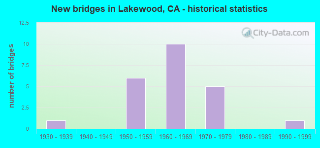
- New bridges - historical statistics
- 11930-1939
- 61950-1959
- 101960-1969
- 51970-1979
- 11990-1999

- Reconstructed bridges - Historical Statistics
- 11970-1979
- 01980-1989
- 11990-1999


- Bridge Condition - Deck
- 78.6%Good
- 7.1%Satisfactory
- 14.3%Fair

- Bridge Condition - Superstructure
- 7.1%Very good
- 78.6%Good
- 14.3%Fair

- Bridge Condition - Channel
- 18.8%Excellent
- 81.3%Very good

- Bridge Condition - Culverts
- 25.0%Very good
- 50.0%Good
- 25.0%Satisfactory
Find on map >> Show street view
Structure Number: 53 1722, Location: 07-LA-605-R1.74-LKW (Lat: 33.831228, Lng: -118.083622), Route carried "on" structure: Interstate 605, Year Built: 1966, Year Reconstructed: 2001, Status: Open, Structure Length: 5.46m (17.91ft), Average Daily Traffic: 209,000 (year 2009), Truck Traffic: 5%, Average Future Daily Traffic: 240,444 (year 2037), Design Load: HS 20, Features Intersected: CARSON STREET
Minimum Vertical Clearance: 30+ m (98+ ft), Kilometerpoint: 1.740, Lanes on structure: 12, Lanes under structure: 4, Base Highway Network: Yes (Inventory Route: 6, Subroute: 3), Owner: State Highway Agency, Approaching Roadway Width: 57.5m (188.6ft), Skew: 32 degrees, Material/Design: Prestressed concrete continuous, Design/Construction: Stringer/Multi-beam, Number Of Spans In Main Unit: 4, Length of Maximum Span: 18.0m (59.1ft), Curb-To-Curb Width: 57.5m (188.6ft), Out-to-Out Width: 58.7m (192.6ft)
Condition: Deck: Good, Superstructure: Good, Substructure: Good, Operating Rating: 37.9 metric tons, Method Used To Determine Operating Rating: Load and Resistance Factor Rating (LRFR) rating reported by rating factor(RF) method using HL-93 loadings, Inventory Rating: 27.2 metric tons, Method Used To Determine Inventory Rating: Load and Resistance Factor Rating (LRFR) rating reported by rating factor(RF) method using HL-93 loadings, Structural Evaluation: Equal to present minimum criteria, Deck Geometry: Superior to present desirable criteria, Underclear: Meets minimum limits, Approach Roadway Alignment: Superior to present desirable criteria, Designated Inspection Frequency: Every 48 months, Inspection Date: July 2019, Deck Structure Type: Concrete Cast-file-Place
Find on map >> Show street view
Structure Number: 53 1724, Location: 07-LA-605-R2.31-LKW (Lat: 33.838592, Lng: -118.088611), Route carried "on" structure: City street L092, Year Built: 1964, Status: Open, Structure Length: 7.72m (25.33ft), Average Daily Traffic: 4,700 (year 2009), Truck Traffic: 2%, Average Future Daily Traffic: 6,491 (year 2037), Design Load: HS 20, Features Intersected: INTERSTATE 605, Facility Carried by Structure: CENTRALIA ROAD
Minimum Vertical Clearance: 30+ m (98+ ft), Kilometerpoint: 0.000, Lanes on structure: 4, Lanes under structure: 10, Owner: State Highway Agency, Approaching Roadway Width: 15.8m (51.8ft), Skew: 2 degrees, Material/Design: Concrete continuous, Design/Construction: Box Beam or Girders - Multiple, Number Of Spans In Main Unit: 4, Length of Maximum Span: 26.8m (87.9ft), Curb or Sidewalk Widths: Left: 1.5m (4.9ft), Right: 1.5m (4.9ft), Curb-To-Curb Width: 15.8m (51.8ft), Out-to-Out Width: 21.3m (69.9ft)
Condition: Deck: Good, Superstructure: Good, Substructure: Good, Operating Rating: 50.9 metric tons, Method Used To Determine Operating Rating: Load and Resistance Factor Rating (LRFR) rating reported by rating factor(RF) method using HL-93 loadings, Inventory Rating: 39.2 metric tons, Method Used To Determine Inventory Rating: Load and Resistance Factor Rating (LRFR) rating reported by rating factor(RF) method using HL-93 loadings, Structural Evaluation: Better than present minimum criteria, Deck Geometry: Meets minimum limits, Underclear: Somewhat better than minimum adequacy, Approach Roadway Alignment: Superior to present desirable criteria, Designated Inspection Frequency: Every 48 months, Inspection Date: July 2019, Deck Structure Type: Concrete Cast-file-Place
Find on map >> Show street view
Structure Number: 53C0232, Location: 50FT S/O DEL AMO BLVD (Lat: 33.846831, Lng: -118.138125), Route carried "on" structure: City street , Year Built: 1952, Status: Open, Structure Length: 1.43m (4.69ft), Average Daily Traffic: 30,568 (year 2012), Truck Traffic: 2%, Average Future Daily Traffic: 36,682 (year 2040), Design Load: HS 20, Features Intersected: DEL AMO DRN CHAN, Facility Carried by Structure: GRAYWOOD AVE
Minimum Vertical Clearance: 30.47m (99.97ft), Kilometerpoint: 0.000, Lanes on structure: 3, Owner: City or Municipal Highway Agency, Approaching Roadway Width: 11.0m (36.1ft), Material/Design: Concrete, Design/Construction: Slab, Number Of Spans In Main Unit: 1, Length of Maximum Span: 13.4m (44.0ft), Curb or Sidewalk Widths: Left: 1.4m (4.6ft), Right: 1.4m (4.6ft), Curb-To-Curb Width: 10.8m (35.4ft), Out-to-Out Width: 14.3m (46.9ft)
Condition: Deck: Good, Superstructure: Good, Substructure: Good, Channel: Very good, Operating Rating: 84.9 metric tons, Method Used To Determine Operating Rating: Load Factor (LF), Inventory Rating: 50.9 metric tons, Method Used To Determine Inventory Rating: Load Factor (LF), Structural Evaluation: Better than present minimum criteria, Deck Geometry: High priority of replacement, Waterway Adequacy: Equal to present desirable criteria, Approach Roadway Alignment: Equal to present desirable criteria, Designated Inspection Frequency: Every 48 months, Inspection Date: December 2020, Deck Structure Type: Concrete Cast-file-Place, Wearing Surface/Protective System: Wearing Surface: Bituminous
Find on map >> Show street view
Structure Number: 53C0422L, Location: 0.5MI W/O I-605 FWY (Lat: 33.831764, Lng: -118.093536), Route carried "on" structure: City street , Year Built: 1971, Status: Open, Structure Length: 6.83m (22.41ft), Average Daily Traffic: 34,632 (year 2012), Truck Traffic: 3%, Average Future Daily Traffic: 41,558 (year 2041), Design Load: HS 20, Features Intersected: SAN GABRIEL RIV, Facility Carried by Structure: CARSON ST
Minimum Vertical Clearance: 30.47m (99.97ft), Kilometerpoint: 0.000, Lanes on structure: 2, Owner: City or Municipal Highway Agency, Approaching Roadway Width: 9.8m (32.2ft), Skew: 1 degrees, Material/Design: Steel, Design/Construction: Stringer/Multi-beam, Number Of Spans In Main Unit: 3, Length of Maximum Span: 21.9m (71.9ft), Curb or Sidewalk Widths: Left: 1.5m (4.9ft), Right: 0.6m (2.0ft), Curb-To-Curb Width: 7.9m (25.9ft), Out-to-Out Width: 10.8m (35.4ft)
Condition: Deck: Fair, Superstructure: Fair, Substructure: Good, Channel: Excellent, Operating Rating: 79.4 metric tons, Method Used To Determine Operating Rating: Load Factor (LF), Inventory Rating: 47.6 metric tons, Method Used To Determine Inventory Rating: Load Factor (LF), Structural Evaluation: Somewhat better than minimum adequacy, Deck Geometry: High priority of replacement, Waterway Adequacy: Superior to present desirable criteria, Approach Roadway Alignment: Equal to present desirable criteria, Designated Inspection Frequency: Every 24 months, Inspection Date: January 2021, Deck Structure Type: Concrete Cast-file-Place
Find on map >> Show street view
Structure Number: 53C0422R, Location: 0.5MI W/O I-605 FWY (Lat: 33.831633, Lng: -118.093564), Route carried "on" structure: City street , Year Built: 1971, Status: Open, Structure Length: 6.83m (22.41ft), Average Daily Traffic: 34,632 (year 2012), Truck Traffic: 3%, Average Future Daily Traffic: 41,558 (year 2041), Design Load: HS 20, Features Intersected: SAN GABRIEL RIV, Facility Carried by Structure: CARSON ST
Minimum Vertical Clearance: 30.47m (99.97ft), Kilometerpoint: 0.000, Lanes on structure: 2, Owner: City or Municipal Highway Agency, Approaching Roadway Width: 9.8m (32.2ft), Skew: 1 degrees, Material/Design: Steel, Design/Construction: Stringer/Multi-beam, Number Of Spans In Main Unit: 3, Length of Maximum Span: 21.9m (71.9ft), Curb or Sidewalk Widths: Left: 0.6m (2.0ft), Right: 1.6m (5.2ft), Curb-To-Curb Width: 7.9m (25.9ft), Out-to-Out Width: 10.6m (34.8ft)
Condition: Deck: Fair, Superstructure: Fair, Substructure: Good, Channel: Excellent, Operating Rating: 78.7 metric tons, Method Used To Determine Operating Rating: Load Factor (LF), Inventory Rating: 47.3 metric tons, Method Used To Determine Inventory Rating: Load Factor (LF), Structural Evaluation: Somewhat better than minimum adequacy, Deck Geometry: High priority of replacement, Waterway Adequacy: Superior to present desirable criteria, Approach Roadway Alignment: Equal to present desirable criteria, Designated Inspection Frequency: Every 24 months, Inspection Date: January 2021, Deck Structure Type: Concrete Cast-file-Place
Find on map >> Show street view
Structure Number: 53C0453, Location: 0.5MI E/O LAKEWOOD BLVD (Lat: 33.860194, Lng: -118.132292), Route carried "on" structure: City street L074, Year Built: 1962, Status: Open, Structure Length: 0.67m (2.20ft), Average Daily Traffic: 24,092 (year 2012), Truck Traffic: 2%, Average Future Daily Traffic: 28,910 (year 2040), Features Intersected: CLARK AVE DRN, Facility Carried by Structure: SOUTH ST
Minimum Vertical Clearance: 30.47m (99.97ft), Kilometerpoint: 0.000, Lanes on structure: 4, Owner: City or Municipal Highway Agency, Approaching Roadway Width: 23.7m (77.8ft), Material/Design: Concrete, Design/Construction: Culvert, Number Of Spans In Main Unit: 2, Length of Maximum Span: 3.0m (9.8ft), Curb or Sidewalk Widths: Left: 2.9m (9.5ft), Right: 0.0m, Curb-To-Curb Width: 23.7m (77.8ft), Out-to-Out Width: 29.9m (98.1ft)
Condition: Channel: Very good, Culverts: Very good, Operating Rating: 40.5 metric tons, Method Used To Determine Operating Rating: Field evaluation and documented engineering judgment, Inventory Rating: 24.3 metric tons, Method Used To Determine Inventory Rating: Field evaluation and documented engineering judgment, Structural Evaluation: Equal to present minimum criteria, Deck Geometry: Superior to present desirable criteria, Waterway Adequacy: Equal to present desirable criteria, Approach Roadway Alignment: Superior to present desirable criteria, Designated Inspection Frequency: Every 24 months, Inspection Date: December 2020
Find on map >> Show street view
Structure Number: 53C0454, Location: 0.3MI E/O WOODRUFF AVE (Lat: 33.858150, Lng: -118.111678), Route carried "on" structure: City street , Year Built: 1955, Status: Open, Structure Length: 1.25m (4.10ft), Average Daily Traffic: 28,625 (year 2012), Truck Traffic: 4%, Average Future Daily Traffic: 34,350 (year 2039), Design Load: HS 20, Features Intersected: PALO VERDE DRN, Facility Carried by Structure: SOUTH ST
Minimum Vertical Clearance: 30.47m (99.97ft), Kilometerpoint: 0.000, Lanes on structure: 4, Owner: City or Municipal Highway Agency, Approaching Roadway Width: 23.2m (76.1ft), Material/Design: Concrete, Design/Construction: Slab, Number Of Spans In Main Unit: 1, Length of Maximum Span: 11.6m (38.1ft), Curb or Sidewalk Widths: Left: 1.6m (5.2ft), Right: 1.6m (5.2ft), Curb-To-Curb Width: 23.2m (76.1ft), Out-to-Out Width: 26.0m (85.3ft)
Condition: Deck: Satisfactory, Superstructure: Good, Substructure: Good, Channel: Very good, Operating Rating: 64.8 metric tons, Method Used To Determine Operating Rating: Load Factor (LF), Inventory Rating: 38.9 metric tons, Method Used To Determine Inventory Rating: Load Factor (LF), Structural Evaluation: Better than present minimum criteria, Deck Geometry: Superior to present desirable criteria, Waterway Adequacy: Equal to present desirable criteria, Approach Roadway Alignment: Equal to present desirable criteria, Designated Inspection Frequency: Every 48 months, Inspection Date: January 2019, Deck Structure Type: Concrete Cast-file-Place, Wearing Surface/Protective System: Wearing Surface: Bituminous
Find on map >> Show street view
Structure Number: 53C0559, Location: 0.5MI W/O LAKEWOOD BLVD (Lat: 33.832256, Lng: -118.152494), Route carried "on" structure: City street L031, Year Built: 1964, Status: Open, Structure Length: 0.64m (2.10ft), Average Daily Traffic: 31,401 (year 2012), Truck Traffic: 2%, Average Future Daily Traffic: 37,681 (year 2040), Features Intersected: LAKEWOOD COUNTRY CLB PUC, Facility Carried by Structure: CARSON ST
Minimum Vertical Clearance: 13.72m (45.01ft), Kilometerpoint: 0.000, Lanes on structure: 6, Owner: City or Municipal Highway Agency, Approaching Roadway Width: 21.2m (69.6ft), Skew: 20 degrees, Material/Design: Concrete, Design/Construction: Frame, Number Of Spans In Main Unit: 2, Length of Maximum Span: 3.0m (9.8ft), Curb or Sidewalk Widths: Left: 1.7m (5.6ft), Right: 2.2m (7.2ft), Curb-To-Curb Width: 21.2m (69.6ft), Out-to-Out Width: 29.7m (97.4ft)
Condition: Deck: Good, Superstructure: Good, Substructure: Good, Channel: Excellent, Operating Rating: 40.5 metric tons, Method Used To Determine Operating Rating: Field evaluation and documented engineering judgment, Inventory Rating: 24.3 metric tons, Method Used To Determine Inventory Rating: Field evaluation and documented engineering judgment, Structural Evaluation: Equal to present minimum criteria, Deck Geometry: High priority of replacement, Waterway Adequacy: Superior to present desirable criteria, Approach Roadway Alignment: Superior to present desirable criteria, Designated Inspection Frequency: Every 48 months, Inspection Date: January 2021, Deck Structure Type: Concrete Cast-file-Place, Wearing Surface/Protective System: Wearing Surface: Bituminous
Find on map >> Show street view
Structure Number: 53C0623, Location: 0.4MI W/O LAKEWOOD BLVD (Lat: 33.847053, Lng: -118.150531), Route carried "on" structure: City street L073, Year Built: 1953, Status: Open, Structure Length: 1.22m (4.00ft), Average Daily Traffic: 29,969 (year 2012), Truck Traffic: 4%, Average Future Daily Traffic: 35,963 (year 2040), Design Load: HS 20, Features Intersected: DOWNEY AVE DRN, Facility Carried by Structure: DEL AMO BLVD
Minimum Vertical Clearance: 30.47m (99.97ft), Kilometerpoint: 0.000, Lanes on structure: 4, Owner: City or Municipal Highway Agency, Approaching Roadway Width: 21.6m (70.9ft), Skew: 20 degrees, Material/Design: Concrete, Design/Construction: Culvert, Number Of Spans In Main Unit: 2, Length of Maximum Span: 5.5m (18.0ft), Curb or Sidewalk Widths: Left: 3.4m (11.2ft), Right: 0.7m (2.3ft), Curb-To-Curb Width: 21.6m (70.9ft), Out-to-Out Width: 27.5m (90.2ft)
Condition: Channel: Very good, Culverts: Good, Operating Rating: 54.1 metric tons, Method Used To Determine Operating Rating: Field evaluation and documented engineering judgment, Inventory Rating: 32.4 metric tons, Method Used To Determine Inventory Rating: Field evaluation and documented engineering judgment, Structural Evaluation: Better than present minimum criteria, Deck Geometry: Superior to present desirable criteria, Waterway Adequacy: Equal to present desirable criteria, Approach Roadway Alignment: Equal to present desirable criteria, Designated Inspection Frequency: Every 48 months, Inspection Date: December 2020
Find on map >> Show street view
Structure Number: 53C0629, Location: 0.1MI E/O BLOOMFIELD AVE (Lat: 33.838703, Lng: -118.061017), Route carried "on" structure: County highway L092, Year Built: 1955, Year Reconstructed: 1976, Status: Open, Structure Length: 6.46m (21.19ft), Average Daily Traffic: 12,000 (year 2012), Truck Traffic: 2%, Average Future Daily Traffic: 13,799 (year 2038), Design Load: HS 20, Features Intersected: COYOTE CRK, Facility Carried by Structure: CENTRALIA ST
Minimum Vertical Clearance: 30.47m (99.97ft), Kilometerpoint: 0.000, Lanes on structure: 4, Owner: County Highway Agency, Approaching Roadway Width: 19.5m (64.0ft), Material/Design: Steel continuous, Design/Construction: Stringer/Multi-beam, Number Of Spans In Main Unit: 3, Length of Maximum Span: 21.3m (69.9ft), Curb or Sidewalk Widths: Left: 1.5m (4.9ft), Right: 1.5m (4.9ft), Curb-To-Curb Width: 19.5m (64.0ft), Out-to-Out Width: 23.2m (76.1ft)
Condition: Deck: Good, Superstructure: Very good, Substructure: Good, Channel: Very good, Operating Rating: 74.2 metric tons, Method Used To Determine Operating Rating: Load Factor (LF), Inventory Rating: 37.3 metric tons, Method Used To Determine Inventory Rating: Load Factor (LF), Structural Evaluation: Better than present minimum criteria, Deck Geometry: Better than present minimum criteria, Waterway Adequacy: Equal to present desirable criteria, Approach Roadway Alignment: Equal to present desirable criteria, Designated Inspection Frequency: Every 48 months, Inspection Date: January 2019, Deck Structure Type: Concrete Cast-file-Place, Wearing Surface/Protective System: Wearing Surface: Monolithic Concrete, Deck Protection: Bituminous
Find on map >> Show street view
Structure Number: 53C0644, Location: 0.9MI E/O BELLFLOWER BLV (Lat: 33.853108, Lng: -118.111428), Route carried "on" structure: City street Q827, Year Built: 1956, Status: Open, Structure Length: 1.62m (5.31ft), Average Daily Traffic: 3,949 (year 2012), Truck Traffic: 1%, Average Future Daily Traffic: 4,344 (year 2040), Design Load: HS 20, Features Intersected: PALO VERDE DRN, Facility Carried by Structure: CANDLEWOOD ST
Minimum Vertical Clearance: 9.14m (29.99ft), Kilometerpoint: 0.000, Lanes on structure: 2, Owner: City or Municipal Highway Agency, Approaching Roadway Width: 14.6m (47.9ft), Skew: 2 degrees, Material/Design: Concrete, Design/Construction: Box Beam or Girders - Single/Spread, Number Of Spans In Main Unit: 1, Length of Maximum Span: 15.2m (49.9ft), Curb or Sidewalk Widths: Left: 1.6m (5.2ft), Right: 1.6m (5.2ft), Curb-To-Curb Width: 19.5m (64.0ft), Out-to-Out Width: 22.9m (75.1ft)
Condition: Deck: Good, Superstructure: Good, Substructure: Good, Channel: Very good, Operating Rating: 82.3 metric tons, Method Used To Determine Operating Rating: Load Factor (LF), Inventory Rating: 49.2 metric tons, Method Used To Determine Inventory Rating: Load Factor (LF), Structural Evaluation: Better than present minimum criteria, Deck Geometry: Superior to present desirable criteria, Waterway Adequacy: Equal to present desirable criteria, Approach Roadway Alignment: Equal to present desirable criteria, Designated Inspection Frequency: Every 48 months, Inspection Date: January 2021, Deck Structure Type: Concrete Cast-file-Place
Find on map >> Show street view
Structure Number: 53C0718, Location: 0.5MI W/O LAKEWOOD BLVD (Lat: 33.850200, Lng: -118.150533), Route carried "on" structure: City street , Year Built: 1959, Status: Open, Structure Length: 0.76m (2.49ft), Average Daily Traffic: 4,379 (year 2012), Truck Traffic: 2%, Average Future Daily Traffic: 4,817 (year 2041), Design Load: HS 20, Features Intersected: DOWNEY AVE DRN, Facility Carried by Structure: HARDWICK ST
Minimum Vertical Clearance: 30.47m (99.97ft), Kilometerpoint: 0.000, Lanes on structure: 2, Owner: City or Municipal Highway Agency, Approaching Roadway Width: 11.0m (36.1ft), Material/Design: Concrete, Design/Construction: Slab, Number Of Spans In Main Unit: 1, Length of Maximum Span: 6.7m (22.0ft), Curb or Sidewalk Widths: Left: 1.2m (3.9ft), Right: 1.2m (3.9ft), Curb-To-Curb Width: 11.0m (36.1ft), Out-to-Out Width: 13.6m (44.6ft)
Condition: Deck: Good, Superstructure: Good, Substructure: Good, Channel: Very good, Operating Rating: 53.8 metric tons, Method Used To Determine Operating Rating: Load Factor (LF), Inventory Rating: 32.4 metric tons, Method Used To Determine Inventory Rating: Load Factor (LF), Structural Evaluation: Better than present minimum criteria, Deck Geometry: Somewhat better than minimum adequacy, Waterway Adequacy: Equal to present desirable criteria, Approach Roadway Alignment: Equal to present desirable criteria, Designated Inspection Frequency: Every 48 months, Inspection Date: January 2021, Deck Structure Type: Concrete Cast-file-Place, Wearing Surface/Protective System: Wearing Surface: Epoxy Overlay
Find on map >> Show street view
Structure Number: 53C0722, Location: 150FT W/O PALO VERDE AVE (Lat: 33.839458, Lng: -118.108383), Route carried "on" structure: City street L092, Year Built: 1977, Status: Open, Structure Length: 0.98m (3.22ft), Average Daily Traffic: 2,130 (year 2012), Truck Traffic: 2%, Average Future Daily Traffic: 2,343 (year 2040), Design Load: HS 20, Features Intersected: PALO VERDE DRN, Facility Carried by Structure: CENTRALIA ST
Minimum Vertical Clearance: 30+ m (98+ ft), Kilometerpoint: 0.000, Lanes on structure: 2, Owner: City or Municipal Highway Agency, Approaching Roadway Width: 11.0m (36.1ft), Material/Design: Concrete, Design/Construction: Slab, Number Of Spans In Main Unit: 1, Length of Maximum Span: 7.9m (25.9ft), Curb or Sidewalk Widths: Left: 2.2m (7.2ft), Right: 2.2m (7.2ft), Curb-To-Curb Width: 10.8m (35.4ft), Out-to-Out Width: 15.8m (51.8ft)
Condition: Deck: Good, Superstructure: Good, Substructure: Good, Channel: Very good, Operating Rating: 63.2 metric tons, Method Used To Determine Operating Rating: Load Factor (LF), Inventory Rating: 37.9 metric tons, Method Used To Determine Inventory Rating: Load Factor (LF), Structural Evaluation: Better than present minimum criteria, Deck Geometry: Somewhat better than minimum adequacy, Waterway Adequacy: Equal to present desirable criteria, Approach Roadway Alignment: Equal to present desirable criteria, Designated Inspection Frequency: Every 48 months, Inspection Date: January 2021, Deck Structure Type: Concrete Cast-file-Place, Wearing Surface/Protective System: Wearing Surface: Epoxy Overlay
Find on map >> Show street view
Structure Number: 53C0723, Location: 150FT W/O PALO VERDE AVE (Lat: 33.835911, Lng: -118.108397), Route carried "on" structure: City street Q823, Year Built: 1977, Status: Open, Structure Length: 0.98m (3.22ft), Average Daily Traffic: 4,374 (year 2012), Truck Traffic: 2%, Average Future Daily Traffic: 4,811 (year 2040), Design Load: HS 20, Features Intersected: PALO VERDE DRN, Facility Carried by Structure: HARVEY WAY
Minimum Vertical Clearance: 30.47m (99.97ft), Kilometerpoint: 0.000, Lanes on structure: 4, Owner: City or Municipal Highway Agency, Approaching Roadway Width: 18.3m (60.0ft), Material/Design: Concrete, Design/Construction: Slab, Number Of Spans In Main Unit: 1, Length of Maximum Span: 7.9m (25.9ft), Curb or Sidewalk Widths: Left: 2.7m (8.9ft), Right: 2.7m (8.9ft), Curb-To-Curb Width: 18.3m (60.0ft), Out-to-Out Width: 24.4m (80.1ft)
Condition: Deck: Good, Superstructure: Good, Substructure: Good, Channel: Very good, Operating Rating: 81.3 metric tons, Method Used To Determine Operating Rating: Load Factor (LF), Inventory Rating: 48.6 metric tons, Method Used To Determine Inventory Rating: Load Factor (LF), Structural Evaluation: Better than present minimum criteria, Deck Geometry: Somewhat better than minimum adequacy, Waterway Adequacy: Equal to present desirable criteria, Approach Roadway Alignment: Equal to present desirable criteria, Designated Inspection Frequency: Every 48 months, Inspection Date: December 2020, Deck Structure Type: Concrete Cast-file-Place
Find on map >> Show street view
Structure Number: 53C0782, Location: 200FT E/O DOWNEY AVE (Lat: 33.853756, Lng: -118.150519), Route carried "on" structure: City street , Year Built: 1960, Status: Open, Structure Length: 0.76m (2.49ft), Average Daily Traffic: 14,639 (year 2012), Truck Traffic: 2%, Average Future Daily Traffic: 16,835 (year 2040), Design Load: HS 20, Features Intersected: DOWNEY AVE DRN, Facility Carried by Structure: CANDLEWOOD ST
Minimum Vertical Clearance: 30.47m (99.97ft), Kilometerpoint: 0.000, Lanes on structure: 4, Owner: City or Municipal Highway Agency, Approaching Roadway Width: 17.1m (56.1ft), Material/Design: Concrete, Design/Construction: Slab, Number Of Spans In Main Unit: 1, Length of Maximum Span: 6.7m (22.0ft), Curb or Sidewalk Widths: Left: 1.2m (3.9ft), Right: 1.2m (3.9ft), Curb-To-Curb Width: 17.1m (56.1ft), Out-to-Out Width: 19.8m (65.0ft)
Condition: Deck: Good, Superstructure: Good, Substructure: Good, Channel: Very good, Operating Rating: 54.4 metric tons, Method Used To Determine Operating Rating: Load Factor (LF), Inventory Rating: 32.7 metric tons, Method Used To Determine Inventory Rating: Load Factor (LF), Structural Evaluation: Better than present minimum criteria, Deck Geometry: Somewhat better than minimum adequacy, Waterway Adequacy: Equal to present desirable criteria, Approach Roadway Alignment: Equal to present desirable criteria, Designated Inspection Frequency: Every 48 months, Inspection Date: January 2021, Deck Structure Type: Concrete Cast-file-Place, Wearing Surface/Protective System: Wearing Surface: Bituminous
Find on map >> Show street view
Structure Number: 53C0841, Location: 400FT E/O CLARK AVE (Lat: 33.853578, Lng: -118.132269), Route carried "on" structure: City street Q827, Year Built: 1977, Status: Open, Structure Length: 0.76m (2.49ft), Average Daily Traffic: 7,200 (year 2012), Truck Traffic: 1%, Average Future Daily Traffic: 8,280 (year 2040), Design Load: HS 20, Features Intersected: CLARK AVE DRN, Facility Carried by Structure: CANDLEWOOD ST
Minimum Vertical Clearance: 30.47m (99.97ft), Kilometerpoint: 0.000, Lanes on structure: 4, Owner: City or Municipal Highway Agency, Approaching Roadway Width: 10.7m (35.1ft), Material/Design: Concrete, Design/Construction: Culvert, Number Of Spans In Main Unit: 1, Length of Maximum Span: 7.0m (23.0ft), Curb or Sidewalk Widths: Left: 2.1m (6.9ft), Right: 0.0m, Curb-To-Curb Width: 18.3m (60.0ft), Out-to-Out Width: 23.2m (76.1ft)
Condition: Channel: Very good, Culverts: Good, Operating Rating: 54.1 metric tons, Method Used To Determine Operating Rating: Field evaluation and documented engineering judgment, Inventory Rating: 32.4 metric tons, Method Used To Determine Inventory Rating: Field evaluation and documented engineering judgment, Structural Evaluation: Better than present minimum criteria, Deck Geometry: Somewhat better than minimum adequacy, Waterway Adequacy: Equal to present desirable criteria, Approach Roadway Alignment: Equal to present desirable criteria, Designated Inspection Frequency: Every 48 months, Inspection Date: December 2020
Find on map >> Show street view
Structure Number: 53C1484, Location: 0.2MI E/O STUDEBAKER RD (Lat: 33.843242, Lng: -118.091681), Route carried "on" structure: City street , Year Built: 1964, Status: Open, Structure Length: 1.48m (4.86ft), Average Daily Traffic: 28,629 (year 2012), Truck Traffic: 2%, Average Future Daily Traffic: 34,355 (year 2040), Design Load: H 20, Features Intersected: GRIDLEY DRN, Facility Carried by Structure: HARVEST AVE
Minimum Vertical Clearance: 30+ m (98+ ft), Kilometerpoint: 0.000, Lanes on structure: 2, Owner: City or Municipal Highway Agency, Approaching Roadway Width: 11.0m (36.1ft), Skew: 2 degrees, Material/Design: Concrete, Design/Construction: Culvert, Number Of Spans In Main Unit: 2, Length of Maximum Span: 7.4m (24.3ft), Curb or Sidewalk Widths: Left: 1.4m (4.6ft), Right: 1.4m (4.6ft), Curb-To-Curb Width: 10.9m (35.8ft), Out-to-Out Width: 14.3m (46.9ft)
Condition: Channel: Very good, Culverts: Satisfactory, Operating Rating: 54.1 metric tons, Method Used To Determine Operating Rating: Field evaluation and documented engineering judgment, Inventory Rating: 32.4 metric tons, Method Used To Determine Inventory Rating: Field evaluation and documented engineering judgment, Structural Evaluation: Equal to present minimum criteria, Deck Geometry: Meets minimum limits, Waterway Adequacy: Equal to present desirable criteria, Approach Roadway Alignment: Equal to present desirable criteria, Designated Inspection Frequency: Every 48 months, Inspection Date: January 2021
Find on map >> Show street view
Structure Number: 53C2017, Location: 50FT S/O DEL AMO BLVD (Lat: 33.846814, Lng: -118.133675), Route carried "on" structure: City street L066, Year Built: 1996, Status: Open, Structure Length: 1.19m (3.90ft), Average Daily Traffic: 30,568 (year 2012), Truck Traffic: 1%, Average Future Daily Traffic: 36,682 (year 2040), Features Intersected: DEL AMO BLVD CHAN, Facility Carried by Structure: CLARK AVE
Minimum Vertical Clearance: 30.47m (99.97ft), Kilometerpoint: 0.000, Lanes on structure: 5, Owner: City or Municipal Highway Agency, Approaching Roadway Width: 16.8m (55.1ft), Material/Design: Concrete, Design/Construction: Slab, Number Of Spans In Main Unit: 1, Length of Maximum Span: 11.0m (36.1ft), Curb or Sidewalk Widths: Left: 1.9m (6.2ft), Right: 1.9m (6.2ft), Curb-To-Curb Width: 19.4m (63.6ft), Out-to-Out Width: 23.8m (78.1ft)
Condition: Deck: Good, Superstructure: Good, Substructure: Good, Channel: Very good, Operating Rating: 54.1 metric tons, Method Used To Determine Operating Rating: Field evaluation and documented engineering judgment, Inventory Rating: 32.4 metric tons, Method Used To Determine Inventory Rating: Field evaluation and documented engineering judgment, Structural Evaluation: Better than present minimum criteria, Deck Geometry: Meets minimum limits, Waterway Adequacy: Equal to present desirable criteria, Approach Roadway Alignment: Equal to present desirable criteria, Designated Inspection Frequency: Every 48 months, Inspection Date: December 2020, Deck Structure Type: Concrete Cast-file-Place
Find on map >> Show street view
Structure Number: 53 1722, Location: 07-LA-605-R1.74-LKW (Lat: 33.831228, Lng: -118.083622), Route carried "under" structure: City street L031, Year Built: 1966, Structure Length: 0. m, Average Daily Traffic: 24,400 (year 2009), Truck Traffic: 3%, Features Intersected: CARSON STREET, Facility Carried by Structure: INTERSTATE 605
Minimum Vertical Clearance: 4.55m (14.93ft), Kilometerpoint: 0.000, Lanes on structure: 12, Lanes under structure: 4, Material/Design: Prestressed concrete continuous, Design/Construction: Stringer/Multi-beam, Length of Maximum Span: 18.0m (59.1ft)
Find on map >> Show street view
Structure Number: 53 1724, Location: 07-LA-605-R2.31-LKW (Lat: 33.838592, Lng: -118.088611), Route carried "under" structure: Interstate 605, Year Built: 1964, Structure Length: 0. m, Average Daily Traffic: 221,000 (year 2009), Truck Traffic: 6%, Features Intersected: INTERSTATE 605, Facility Carried by Structure: CENTRALIA ROAD
Minimum Vertical Clearance: 5.18m (16.99ft), Kilometerpoint: 2.310, Lanes on structure: 4, Lanes under structure: 10, Material/Design: Concrete continuous, Design/Construction: Box Beam or Girders - Multiple, Length of Maximum Span: 26.8m (87.9ft)
Find on map >> Show street view
Structure Number: 53 1742, Location: 07-LA-605-R2.59-LKW (Lat: 33.842231, Lng: -118.090628), Route carried "under" structure: Interstate 605, Year Built: 1966, Structure Length: 0. m, Average Daily Traffic: 183,100 (year 2011), Truck Traffic: 6%, Features Intersected: INTERSTATE 605, Facility Carried by Structure: PEDESTRIAN WALKWAY
Minimum Vertical Clearance: 5.77m (18.93ft), Kilometerpoint: 2.590, Lanes under structure: 10, Material/Design: Concrete continuous, Design/Construction: Box Beam or Girders - Single/Spread, Length of Maximum Span: 25.3m (83.0ft)
Find on map >> Show street view
Structure Number: 53C0592, Location: 0.5MI S/O S ST (Lat: 33.852325, Lng: -118.167794), Route carried "under" structure: City street , Year Built: 1932, Structure Length: 0. m, Average Daily Traffic: 30,266 (year 2012), Truck Traffic: 2%, Features Intersected: CHERRY AVE, Facility Carried by Structure: UNION PACIFIC RR
Minimum Vertical Clearance: 4.39m (14.40ft), Kilometerpoint: 0.000, Lanes under structure: 5, Material/Design: Steel, Design/Construction: Stringer/Multi-beam, Length of Maximum Span: 28.0m (91.9ft)
Find on map >> Show street view
Structure Number: 53C072, Location: 0.5MI W/O I-605 FW (Lat: 33.846139, Lng: -118.101675), Route carried "under" structure: City street , Year Built: 1966, Structure Length: 0. m, Average Daily Traffic: 28,629 (year 2012), Truck Traffic: 4%, Features Intersected: DEL AMO BOULEVARD, Facility Carried by Structure: MAE BOYER PRK POC
Minimum Vertical Clearance: 5.00m (16.40ft), Kilometerpoint: 0.000, Lanes under structure: 4, Material/Design: Concrete, Design/Construction: Slab, Length of Maximum Span: 14.9m (48.9ft)