Bridge Statistics for Lakeland, Tennessee (TN)
Condition, Traffic, Stress, Structural Evaluation, Project Costs
- National Bridge Inventory (NBI) Statistics
- 43Number of bridges
- 515ft / 157mTotal length
- $19,535,000Total costs
- 346,311Total average daily traffic
- 46,818Total average daily truck traffic
- National Bridge Inventory (NBI) Registered Bridges for Lakeland
- No street view available for this location
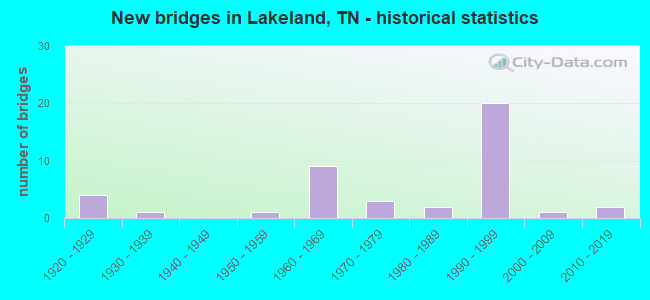
- New bridges - historical statistics
- 41920-1929
- 11930-1939
- 11950-1959
- 91960-1969
- 31970-1979
- 21980-1989
- 201990-1999
- 12000-2009
- 22010-2019

- Reconstructed bridges - Historical Statistics
- 41950-1959
- 01960-1969
- 01970-1979
- 01980-1989
- 11990-1999
- 12000-2009


- Bridge Condition - Deck
- 4.0%Very good
- 36.0%Good
- 44.0%Satisfactory
- 16.0%Fair

- Bridge Condition - Superstructure
- 20.0%Very good
- 24.0%Good
- 32.0%Satisfactory
- 24.0%Fair

- Bridge Condition - Substructure
- 4.0%Very good
- 48.0%Good
- 40.0%Satisfactory
- 8.0%Fair

- Bridge Condition - Channel
- 4.8%Good
- 85.7%Satisfactory
- 9.5%Fair

- Bridge Condition - Culverts
- 14.3%Good
- 85.7%Satisfactory
Find on map >> Show street view
Structure Number: 79014590001, Location: BRUNSWICK RD - SHELBY CO (Lat: 35.279639, Lng: -89.766389), Route carried "on" structure: County highway 1459, Year Built: 1998, Status: Open, Structure Length: 30.78m (100.98ft), Average Daily Traffic: 6,622 (year 2020), Truck Traffic: 4%, Average Future Daily Traffic: 10,944 (year 2041), Design Load: HS 20, Features Intersected: LOOSAHATCHIE RIVER
Minimum Vertical Clearance: 30+ m (98+ ft), Kilometerpoint: 9.543, Lanes on structure: 2, Owner: County Highway Agency, Approaching Roadway Width: 13.3m (43.6ft), Material/Design: Prestressed concrete continuous, Design/Construction: Stringer/Multi-beam, Number Of Spans In Main Unit: 8, Length of Maximum Span: 39.6m (129.9ft), Curb or Sidewalk Widths: Left: 0.0m, Right: 1.5m (4.9ft), Curb-To-Curb Width: 11.6m (38.1ft), Out-to-Out Width: 13.8m (45.3ft)
Condition: Deck: Satisfactory, Superstructure: Good, Substructure: Good, Channel: Satisfactory, Operating Rating: 44.1 metric tons, Method Used To Determine Operating Rating: Assigned rating based on Load Factor Design (LFD) reported in metric tons, Inventory Rating: 32.4 metric tons, Method Used To Determine Inventory Rating: Assigned rating based on Load Factor Design (LFD) reported in metric tons, Structural Evaluation: Better than present minimum criteria, Deck Geometry: Somewhat better than minimum adequacy, Waterway Adequacy: Equal to present desirable criteria, Approach Roadway Alignment: Equal to present desirable criteria, Designated Inspection Frequency: Every 24 months, Inspection Date: Febuary 2021, Deck Structure Type: Concrete Cast-file-Place, Wearing Surface/Protective System: Wearing Surface: Monolithic Concrete, Deck Protection: Epoxy Coated Reinforcing
Find on map >> Show street view
Structure Number: 79014590003, Location: BRUNSWICK RD - SHELBY CO (Lat: 35.332389, Lng: -89.757611), Route carried "on" structure: County highway 1459, Year Built: 1960, Status: Open, Structure Length: 1.55m (5.09ft), Average Daily Traffic: 5,029 (year 2020), Truck Traffic: 3%, Average Future Daily Traffic: 9,920 (year 2041), Design Load: H 10, Features Intersected: BRANCH
Minimum Vertical Clearance: 30+ m (98+ ft), Kilometerpoint: 15.772, Lanes on structure: 2, Owner: County Highway Agency, Approaching Roadway Width: 9.8m (32.2ft), Material/Design: Concrete, Design/Construction: Channel Beam, Number Of Spans In Main Unit: 3, Length of Maximum Span: 5.2m (17.1ft), Curb-To-Curb Width: 8.6m (28.2ft), Out-to-Out Width: 10.4m (34.1ft)
Condition: Deck: Satisfactory, Superstructure: Satisfactory, Substructure: Satisfactory, Channel: Satisfactory, Operating Rating: 36.0 metric tons, Method Used To Determine Operating Rating: Field evaluation and documented engineering judgment, Inventory Rating: 24.3 metric tons, Method Used To Determine Inventory Rating: Field evaluation and documented engineering judgment, Structural Evaluation: Equal to present minimum criteria, Deck Geometry: High priority of replacement, Waterway Adequacy: Equal to present desirable criteria, Approach Roadway Alignment: Equal to present desirable criteria, Length Of Structure Improvement: 1.55m (5.09ft), Designated Inspection Frequency: Every 24 months, Inspection Date: Febuary 2021, Bridge Improvement Cost: $150,000, Roadway Improvement Cost: $16,000, Total Project Cost: $226,000 ( Estimate for 2021), Deck Structure Type: Concrete Precast Panels, Wearing Surface/Protective System: Wearing Surface: Bituminous
Find on map >> Show street view
Structure Number: 79014590005, Location: BRUNSWICK RD - SHELBY CO (Lat: 35.348856, Lng: -89.744222), Route carried "on" structure: County highway 1459, Year Built: 2003, Status: Open, Structure Length: 2.00m (6.56ft), Average Daily Traffic: 5,641 (year 2020), Truck Traffic: 3%, Average Future Daily Traffic: 64 (year 2041), Design Load: HS 20, Features Intersected: BRANCH
Minimum Vertical Clearance: 30+ m (98+ ft), Kilometerpoint: 18.025, Lanes on structure: 2, Owner: County Highway Agency, Approaching Roadway Width: 13.4m (44.0ft), Skew: 3 degrees, Material/Design: Concrete continuous, Design/Construction: Culvert, Number Of Spans In Main Unit: 3, Length of Maximum Span: 5.5m (18.0ft), Curb-To-Curb Width: 10.4m (34.1ft), Out-to-Out Width: 15.9m (52.2ft)
Condition: Channel: Satisfactory, Culverts: Satisfactory, Operating Rating: 44.1 metric tons, Method Used To Determine Operating Rating: Assigned rating based on Load Factor Design (LFD) reported in metric tons, Inventory Rating: 32.4 metric tons, Method Used To Determine Inventory Rating: Assigned rating based on Load Factor Design (LFD) reported in metric tons, Structural Evaluation: Equal to present minimum criteria, Deck Geometry: Meets minimum limits, Waterway Adequacy: Equal to present desirable criteria, Approach Roadway Alignment: Equal to present desirable criteria, Designated Inspection Frequency: Every 24 months, Inspection Date: Febuary 2021, Deck Structure Type: Concrete Cast-file-Place, Wearing Surface/Protective System: Wearing Surface: Monolithic Concrete, Deck Protection: Epoxy Coated Reinforcing
Find on map >> Show street view
Structure Number: 790A1470001, Location: MOOSE RD - SHELBY CO (Lat: 35.364167, Lng: -89.700111), Route carried "on" structure: County highway 10, Year Built: 1931, Status: Posted for load, Structure Length: 3.47m (11.38ft), Average Daily Traffic: 110 (year 2022), Truck Traffic: 2%, Average Future Daily Traffic: 176 (year 2042), Design Load: H 15, Features Intersected: W. BEAVER CREEK
Minimum Vertical Clearance: 30+ m (98+ ft), Kilometerpoint: 2.213, Lanes on structure: 2, Owner: County Highway Agency, Approaching Roadway Width: 11.0m (36.1ft), Material/Design: Steel, Design/Construction: Truss - Thru, Number Of Spans In Main Unit: 1, Length of Maximum Span: 34.7m (113.8ft), Curb-To-Curb Width: 6.1m (20.0ft), Out-to-Out Width: 6.4m (21.0ft)
Condition: Deck: Good, Superstructure: Satisfactory, Substructure: Satisfactory, Channel: Fair, Operating Rating: 10.4 metric tons, Method Used To Determine Operating Rating: Load and Resistance Factor Rating (LRFR) rating reported by rating factor(RF) method using HL-93 loadings, Inventory Rating: 8.1 metric tons, Method Used To Determine Inventory Rating: Load and Resistance Factor Rating (LRFR) rating reported by rating factor(RF) method using HL-93 loadings, Structural Evaluation: High priority of corrective action, Deck Geometry: Meets minimum limits, Waterway Adequacy: Equal to present desirable criteria, Approach Roadway Alignment: Equal to present desirable criteria, Bridge Posting: Required (Relationship of Operating Rating to Maximum Legal Load: 10.0 - 19.9% below), Length Of Structure Improvement: 3.47m (11.38ft), Designated Inspection Frequency: Every 24 months, Critical Feature Inspection Frequency: Every 24 months, Inspection Date: Febuary 2021, Critical Feature Inspection Date: Febuary 2021, Bridge Improvement Cost: $301,000, Roadway Improvement Cost: $31,000, Total Project Cost: $452,000 ( Estimate for 2022), Deck Structure Type: Corrugated Steel, Wearing Surface/Protective System: Wearing Surface: Monolithic Concrete
Find on map >> Show street view
Structure Number: 790A1600001, Location: PLEASANT RIDGE RD-SHELBY (Lat: 35.318111, Lng: -89.711444), Route carried "on" structure: County highway 4, Year Built: 1964, Status: Open, Structure Length: 1.55m (5.09ft), Average Daily Traffic: 190 (year 2022), Truck Traffic: 2%, Average Future Daily Traffic: 304 (year 2041), Design Load: H 15, Features Intersected: BRANCH
Minimum Vertical Clearance: 30+ m (98+ ft), Kilometerpoint: 1.548, Lanes on structure: 2, Owner: County Highway Agency, Approaching Roadway Width: 9.1m (29.9ft), Material/Design: Concrete, Design/Construction: Channel Beam, Number Of Spans In Main Unit: 3, Length of Maximum Span: 5.2m (17.1ft), Curb-To-Curb Width: 8.6m (28.2ft), Out-to-Out Width: 9.9m (32.5ft)
Condition: Deck: Satisfactory, Superstructure: Fair, Substructure: Satisfactory, Channel: Satisfactory, Operating Rating: 36.0 metric tons, Method Used To Determine Operating Rating: Field evaluation and documented engineering judgment, Inventory Rating: 24.3 metric tons, Method Used To Determine Inventory Rating: Field evaluation and documented engineering judgment, Structural Evaluation: Somewhat better than minimum adequacy, Deck Geometry: Equal to present minimum criteria, Waterway Adequacy: Equal to present desirable criteria, Approach Roadway Alignment: Equal to present minimum criteria, Designated Inspection Frequency: Every 24 months, Inspection Date: Febuary 2021, Deck Structure Type: Concrete Precast Panels, Wearing Surface/Protective System: Wearing Surface: Bituminous
Find on map >> Show street view
Structure Number: 790A1650001, Location: STEWART RD - LAKELAND (Lat: 35.287972, Lng: -89.757361), Route carried "on" structure: City street 34, Year Built: 1970, Year Reconstructed: 2013, Status: Open, Structure Length: 1.55m (5.09ft), Average Daily Traffic: 360 (year 2022), Truck Traffic: 2%, Average Future Daily Traffic: 576 (year 2041), Design Load: H 15, Features Intersected: BRANCH
Minimum Vertical Clearance: 30+ m (98+ ft), Kilometerpoint: 0.280, Lanes on structure: 2, Owner: City or Municipal Highway Agency, Approaching Roadway Width: 8.5m (27.9ft), Material/Design: Concrete, Design/Construction: Channel Beam, Number Of Spans In Main Unit: 3, Length of Maximum Span: 5.2m (17.1ft), Curb-To-Curb Width: 8.6m (28.2ft), Out-to-Out Width: 10.0m (32.8ft)
Condition: Deck: Very good, Superstructure: Very good, Substructure: Satisfactory, Channel: Satisfactory, Operating Rating: 36.0 metric tons, Method Used To Determine Operating Rating: Field evaluation and documented engineering judgment, Inventory Rating: 24.3 metric tons, Method Used To Determine Inventory Rating: Field evaluation and documented engineering judgment, Structural Evaluation: Equal to present minimum criteria, Deck Geometry: Equal to present minimum criteria, Waterway Adequacy: Equal to present desirable criteria, Approach Roadway Alignment: Equal to present desirable criteria, Length Of Structure Improvement: 1.55m (5.09ft), Designated Inspection Frequency: Every 24 months, Inspection Date: January 2021, Bridge Improvement Cost: $244,000, Roadway Improvement Cost: $25,000, Total Project Cost: $367,000 ( Estimate for 2021), Deck Structure Type: Concrete Precast Panels, Wearing Surface/Protective System: Wearing Surface: Bituminous
Find on map >> Show street view
Structure Number: 790A1840001, Location: OLD BROWNSVILLE RD (Lat: 35.263917, Lng: -89.764889), Route carried "on" structure: City street 2178, Year Built: 1954, Status: Open, Structure Length: 2.04m (6.69ft), Average Daily Traffic: 2,640 (year 2020), Truck Traffic: 4%, Average Future Daily Traffic: 2,336 (year 2041), Design Load: H 10, Features Intersected: OLIVER CREEK
Minimum Vertical Clearance: 30+ m (98+ ft), Kilometerpoint: 10.203, Lanes on structure: 2, Owner: City or Municipal Highway Agency, Approaching Roadway Width: 8.5m (27.9ft), Material/Design: Concrete, Design/Construction: Tee Beam, Number Of Spans In Main Unit: 1, Number Of Approach Spans: 2, Length of Maximum Span: 10.4m (34.1ft), Curb-To-Curb Width: 8.6m (28.2ft), Out-to-Out Width: 9.8m (32.2ft)
Condition: Deck: Fair, Superstructure: Fair, Substructure: Satisfactory, Channel: Satisfactory, Operating Rating: 36.0 metric tons, Method Used To Determine Operating Rating: Field evaluation and documented engineering judgment, Inventory Rating: 24.3 metric tons, Method Used To Determine Inventory Rating: Field evaluation and documented engineering judgment, Structural Evaluation: Somewhat better than minimum adequacy, Deck Geometry: Meets minimum limits, Waterway Adequacy: Equal to present desirable criteria, Approach Roadway Alignment: Equal to present desirable criteria, Length Of Structure Improvement: 2.04m (6.69ft), Designated Inspection Frequency: Every 24 months, Inspection Date: January 2021, Bridge Improvement Cost: $364,000, Roadway Improvement Cost: $37,000, Total Project Cost: $547,000 ( Estimate for 2021), Deck Structure Type: Other, Wearing Surface/Protective System: Wearing Surface: Bituminous
Find on map >> Show street view
Structure Number: 790A1870001, Location: DONNELL RD - SHELBY CO (Lat: 35.323083, Lng: -89.790528), Route carried "on" structure: County highway 39, Year Built: 1971, Status: Open, Structure Length: 4.30m (14.11ft), Average Daily Traffic: 170 (year 2022), Truck Traffic: 2%, Average Future Daily Traffic: 272 (year 2041), Design Load: H 15, Features Intersected: CROOKED CREEK
Minimum Vertical Clearance: 30+ m (98+ ft), Kilometerpoint: 2.066, Lanes on structure: 2, Owner: County Highway Agency, Approaching Roadway Width: 9.1m (29.9ft), Material/Design: Steel, Design/Construction: Stringer/Multi-beam, Number Of Spans In Main Unit: 1, Number Of Approach Spans: 6, Length of Maximum Span: 11.9m (39.0ft), Curb-To-Curb Width: 8.7m (28.5ft), Out-to-Out Width: 10.0m (32.8ft)
Condition: Deck: Satisfactory, Superstructure: Satisfactory, Substructure: Satisfactory, Channel: Fair, Operating Rating: 32.4 metric tons, Method Used To Determine Operating Rating: Allowable Stress (AS), Inventory Rating: 18.9 metric tons, Method Used To Determine Inventory Rating: Allowable Stress (AS), Structural Evaluation: Somewhat better than minimum adequacy, Deck Geometry: Equal to present minimum criteria, Waterway Adequacy: Equal to present desirable criteria, Approach Roadway Alignment: Equal to present desirable criteria, Length Of Structure Improvement: 4.30m (14.11ft), Designated Inspection Frequency: Every 24 months, Inspection Date: Febuary 2021, Bridge Improvement Cost: $642,000, Roadway Improvement Cost: $65,000, Total Project Cost: $964,000 ( Estimate for 2021), Deck Structure Type: Concrete Cast-file-Place, Wearing Surface/Protective System: Wearing Surface: Bituminous
Find on map >> Show street view
Structure Number: 790A6410001, Location: APPLING RD - MEMPHIS (Lat: 35.218972, Lng: -89.807833), Route carried "on" structure: City street 4452, Year Built: 1965, Status: Open, Structure Length: 0.88m (2.89ft), Average Daily Traffic: 4,157 (year 2020), Truck Traffic: 4%, Average Future Daily Traffic: 5,472 (year 2041), Design Load: H 10, Features Intersected: BRANCH
Minimum Vertical Clearance: 30+ m (98+ ft), Kilometerpoint: 1.593, Lanes on structure: 2, Owner: City or Municipal Highway Agency, Approaching Roadway Width: 9.8m (32.2ft), Skew: 3 degrees, Material/Design: Concrete continuous, Design/Construction: Culvert, Number Of Spans In Main Unit: 2, Length of Maximum Span: 3.7m (12.1ft)
Condition: Channel: Satisfactory, Culverts: Satisfactory, Operating Rating: 72.0 metric tons, Method Used To Determine Operating Rating: Load Factor (LF), Inventory Rating: 32.4 metric tons, Method Used To Determine Inventory Rating: Load Factor (LF), Structural Evaluation: Equal to present minimum criteria, Waterway Adequacy: Equal to present desirable criteria, Approach Roadway Alignment: Equal to present desirable criteria, Designated Inspection Frequency: Every 24 months, Inspection Date: January 2021
Find on map >> Show street view
Structure Number: 790A6480001, Location: MEMPHIS-ARLINGTON RD (Lat: 35.247417, Lng: -89.756861), Route carried "on" structure: City street 889, Year Built: 1976, Status: Open, Structure Length: 0.64m (2.10ft), Average Daily Traffic: 5,156 (year 2020), Truck Traffic: 5%, Average Future Daily Traffic: 544 (year 2041), Design Load: HS 20, Features Intersected: OLIVER CREEK
Minimum Vertical Clearance: 30+ m (98+ ft), Kilometerpoint: 3.093, Lanes on structure: 2, Owner: Town or Township Highway Agency, Approaching Roadway Width: 14.6m (47.9ft), Skew: 1 degrees, Material/Design: Concrete continuous, Design/Construction: Culvert, Number Of Spans In Main Unit: 2, Length of Maximum Span: 3.0m (9.8ft)
Condition: Channel: Satisfactory, Culverts: Good, Operating Rating: 89.9 metric tons, Method Used To Determine Operating Rating: Load Factor (LF), Inventory Rating: 32.4 metric tons, Method Used To Determine Inventory Rating: Load Factor (LF), Structural Evaluation: Better than present minimum criteria, Waterway Adequacy: Equal to present desirable criteria, Approach Roadway Alignment: Equal to present minimum criteria, Designated Inspection Frequency: Every 24 months, Inspection Date: January 2021
Find on map >> Show street view
Structure Number: 790A6480003, Location: MEMPHIS-ARLINGTON RD-SHEL (Lat: 35.268083, Lng: -89.700861), Route carried "on" structure: County highway 889, Year Built: 1994, Status: Open, Structure Length: 4.72m (15.49ft), Average Daily Traffic: 5,156 (year 2020), Truck Traffic: 5%, Average Future Daily Traffic: 1,360 (year 2041), Design Load: HS 20, Features Intersected: CLEAR CREEK, Facility Carried by Structure: NFA K861
Minimum Vertical Clearance: 30+ m (98+ ft), Kilometerpoint: 9.820, Lanes on structure: 2, Owner: City or Municipal Highway Agency, Approaching Roadway Width: 10.1m (33.1ft), Material/Design: Prestressed concrete continuous, Design/Construction: Stringer/Multi-beam, Number Of Spans In Main Unit: 3, Length of Maximum Span: 15.5m (50.9ft), Curb-To-Curb Width: 9.4m (30.8ft), Out-to-Out Width: 10.1m (33.1ft)
Condition: Deck: Good, Superstructure: Very good, Substructure: Good, Channel: Satisfactory, Operating Rating: 44.1 metric tons, Method Used To Determine Operating Rating: Assigned rating based on Load Factor Design (LFD) reported in metric tons, Inventory Rating: 32.4 metric tons, Method Used To Determine Inventory Rating: Assigned rating based on Load Factor Design (LFD) reported in metric tons, Structural Evaluation: Better than present minimum criteria, Deck Geometry: High priority of corrective action, Waterway Adequacy: Equal to present desirable criteria, Approach Roadway Alignment: Equal to present desirable criteria, Designated Inspection Frequency: Every 24 months, Inspection Date: January 2021, Deck Structure Type: Concrete Cast-file-Place, Wearing Surface/Protective System: Wearing Surface: Monolithic Concrete, Deck Protection: Epoxy Coated Reinforcing
Find on map >> Show street view
Structure Number: 790A6630001, Location: COBB RD - SHELBY CO (Lat: 35.213750, Lng: -89.720028), Route carried "on" structure: County highway 963, Year Built: 1965, Status: Open, Structure Length: 0.67m (2.20ft), Average Daily Traffic: 110 (year 2022), Truck Traffic: 2%, Average Future Daily Traffic: 176 (year 2041), Design Load: HS 20, Features Intersected: BRANCH
Minimum Vertical Clearance: 30+ m (98+ ft), Kilometerpoint: 2.235, Lanes on structure: 2, Owner: County Highway Agency, Approaching Roadway Width: 7.3m (24.0ft), Material/Design: Concrete, Design/Construction: Culvert, Number Of Spans In Main Unit: 2, Length of Maximum Span: 2.1m (6.9ft)
Condition: Channel: Satisfactory, Culverts: Satisfactory, Operating Rating: 54.0 metric tons, Method Used To Determine Operating Rating: Field evaluation and documented engineering judgment, Inventory Rating: 32.4 metric tons, Method Used To Determine Inventory Rating: Field evaluation and documented engineering judgment, Structural Evaluation: Equal to present minimum criteria, Waterway Adequacy: Equal to present desirable criteria, Approach Roadway Alignment: Equal to present desirable criteria, Designated Inspection Frequency: Every 24 months, Inspection Date: January 2021
Find on map >> Show street view
Structure Number: 790C0100003, Location: MOOSE RD - SHELBY CO (Lat: 35.364083, Lng: -89.698139), Route carried "on" structure: County highway 10, Year Built: 1988, Status: Open, Structure Length: 0.73m (2.40ft), Average Daily Traffic: 110 (year 2022), Truck Traffic: 2%, Average Future Daily Traffic: 176 (year 2041), Design Load: HS 20, Features Intersected: WEST BEAVER CREEK
Minimum Vertical Clearance: 30+ m (98+ ft), Kilometerpoint: 2.578, Lanes on structure: 2, Owner: County Highway Agency, Approaching Roadway Width: 10.1m (33.1ft), Material/Design: Concrete continuous, Design/Construction: Culvert, Number Of Spans In Main Unit: 2, Length of Maximum Span: 3.0m (9.8ft)
Condition: Channel: Satisfactory, Culverts: Satisfactory, Operating Rating: 54.0 metric tons, Method Used To Determine Operating Rating: Field evaluation and documented engineering judgment, Inventory Rating: 32.4 metric tons, Method Used To Determine Inventory Rating: Field evaluation and documented engineering judgment, Structural Evaluation: Equal to present minimum criteria, Waterway Adequacy: Better than present minimum criteria, Approach Roadway Alignment: Equal to present desirable criteria, Designated Inspection Frequency: Every 24 months, Inspection Date: Febuary 2021
Find on map >> Show street view
Structure Number: 790D9650001, Location: PLANTATION WOODS DRIVE (Lat: 35.212100, Lng: -89.715417), Route carried "on" structure: County highway 965, Year Built: 1965, Status: Open, Structure Length: 0.82m (2.69ft), Average Daily Traffic: 50 (year 2022), Truck Traffic: 2%, Average Future Daily Traffic: 80 (year 2041), Design Load: HS 20, Features Intersected: BRANCH
Minimum Vertical Clearance: 30+ m (98+ ft), Kilometerpoint: 0.439, Lanes on structure: 2, Owner: County Highway Agency, Approaching Roadway Width: 8.5m (27.9ft), Skew: 1 degrees, Material/Design: Concrete continuous, Design/Construction: Culvert, Number Of Spans In Main Unit: 2, Length of Maximum Span: 4.1m (13.5ft), Curb-To-Curb Width: 8.7m (28.5ft), Out-to-Out Width: 10.0m (32.8ft)
Condition: Channel: Satisfactory, Culverts: Satisfactory, Operating Rating: 64.8 metric tons, Method Used To Determine Operating Rating: Load Factor (LF), Inventory Rating: 38.7 metric tons, Method Used To Determine Inventory Rating: Load Factor (LF), Structural Evaluation: Equal to present minimum criteria, Deck Geometry: Better than present minimum criteria, Waterway Adequacy: Equal to present minimum criteria, Approach Roadway Alignment: Equal to present desirable criteria, Length Of Structure Improvement: 0.82m (2.69ft), Designated Inspection Frequency: Every 24 months, Inspection Date: January 2021, Bridge Improvement Cost: $141,000, Roadway Improvement Cost: $15,000, Total Project Cost: $212,000 ( Estimate for 2021), Deck Structure Type: Concrete Cast-file-Place, Wearing Surface/Protective System: Wearing Surface: Bituminous
Find on map >> Show street view
Structure Number: 790L0240001, Location: BRENTBROOK RD-LAKEWOOD (Lat: 35.214889, Lng: -89.717067), Route carried "on" structure: City street 82, Year Built: 1994, Status: Open, Structure Length: 0.80m (2.62ft), Average Daily Traffic: 730 (year 2022), Truck Traffic: 2%, Average Future Daily Traffic: 1,168 (year 2041), Design Load: HS 20, Features Intersected: BRANCH, Facility Carried by Structure: NFA L024
Minimum Vertical Clearance: 30+ m (98+ ft), Kilometerpoint: 0.257, Lanes on structure: 2, Owner: City or Municipal Highway Agency, Approaching Roadway Width: 12.2m (40.0ft), Material/Design: Concrete continuous, Design/Construction: Culvert, Number Of Spans In Main Unit: 2, Length of Maximum Span: 3.0m (9.8ft)
Condition: Channel: Satisfactory, Culverts: Satisfactory, Operating Rating: 63.2 metric tons, Method Used To Determine Operating Rating: Load Factor (LF), Inventory Rating: 32.4 metric tons, Method Used To Determine Inventory Rating: Load Factor (LF), Structural Evaluation: Equal to present minimum criteria, Waterway Adequacy: Equal to present desirable criteria, Approach Roadway Alignment: Equal to present desirable criteria, Designated Inspection Frequency: Every 24 months, Inspection Date: January 2021
Find on map >> Show street view
Structure Number: 79I00400119, Location: 1 M E OF SR177 JCT (Lat: 35.204111, Lng: -89.772500), Route carried "on" structure: Interstate 40, Year Built: 1964, Year Reconstructed: 1997, Status: Open, Structure Length: 11.03m (36.19ft), Average Daily Traffic: 66,152 (year 2020), Truck Traffic: 15%, Average Future Daily Traffic: 105,843 (year 2042), Design Load: HS 20+Mod, Features Intersected: I-40 / US-64
Minimum Vertical Clearance: 30+ m (98+ ft), Kilometerpoint: 34.553, Lanes on structure: 7, Lanes under structure: 5, Base Highway Network: Yes, Owner: State Highway Agency, Approaching Roadway Width: 35.7m (117.1ft), Skew: 35 degrees, Material/Design: Steel continuous, Design/Construction: Stringer/Multi-beam, Number Of Spans In Main Unit: 4, Length of Maximum Span: 33.5m (109.9ft), Curb-To-Curb Width: 35.7m (117.1ft), Out-to-Out Width: 39.8m (130.6ft)
Condition: Deck: Fair, Superstructure: Fair, Substructure: Satisfactory, Operating Rating: 27.9 metric tons, Method Used To Determine Operating Rating: Load and Resistance Factor Rating (LRFR) rating reported by rating factor(RF) method using HL-93 loadings, Inventory Rating: 21.4 metric tons, Method Used To Determine Inventory Rating: Load and Resistance Factor Rating (LRFR) rating reported by rating factor(RF) method using HL-93 loadings, Structural Evaluation: Somewhat better than minimum adequacy, Deck Geometry: Superior to present desirable criteria, Underclear: Somewhat better than minimum adequacy, Approach Roadway Alignment: Equal to present desirable criteria, Length Of Structure Improvement: 11.03m (36.19ft), Designated Inspection Frequency: Every 24 months, Inspection Date: October 2020, Bridge Improvement Cost: $6,900,000, Roadway Improvement Cost: $691,000, Total Project Cost: $10,351,000 ( Estimate for 2022), Deck Structure Type: Concrete Cast-file-Place, Wearing Surface/Protective System: Wearing Surface: Monolithic Concrete, Deck Protection: Epoxy Coated Reinforcing
Find on map >> Show street view
Structure Number: 79I00400123, Location: CANADA RD - LAKELAND (Lat: 35.223083, Lng: -89.736750), Route carried "on" structure: City street 811, Year Built: 2017, Status: Open, Structure Length: 5.17m (16.96ft), Average Daily Traffic: 8,342 (year 2020), Truck Traffic: 4%, Average Future Daily Traffic: 45,104 (year 2040), Design Load: HL 93, Features Intersected: CANADA RD / I-40
Minimum Vertical Clearance: 30+ m (98+ ft), Kilometerpoint: 20.213, Lanes on structure: 60, Lanes under structure: 80, Owner: State Highway Agency, Approaching Roadway Width: 25.6m (84.0ft), Skew: 1 degrees, Material/Design: Prestressed concrete, Design/Construction: Stringer/Multi-beam, Number Of Spans In Main Unit: 2, Length of Maximum Span: 25.8m (84.6ft), Curb-To-Curb Width: 29.6m (97.1ft), Out-to-Out Width: 60.2m (197.5ft)
Condition: Deck: Good, Superstructure: Very good, Substructure: Very good, Operating Rating: 44.1 metric tons, Method Used To Determine Operating Rating: Assigned ratings based on Load and Resistance Factor Design (LRFD) reported by rating factor (RF) using HL93 loadings, Inventory Rating: 32.4 metric tons, Method Used To Determine Inventory Rating: Assigned ratings based on Load and Resistance Factor Design (LRFD) reported by rating factor (RF) using HL93 loadings, Structural Evaluation: Equal to present desirable criteria, Deck Geometry: High priority of replacement, Underclear: Equal to present minimum criteria, Approach Roadway Alignment: Equal to present desirable criteria, Designated Inspection Frequency: Every 24 months, Inspection Date: October 2020, Deck Structure Type: Concrete Cast-file-Place, Wearing Surface/Protective System: Wearing Surface: Monolithic Concrete
Find on map >> Show street view
Structure Number: 79I00400125, Location: CHAMBERS CHAPEL RD-SHELBY (Lat: 35.243278, Lng: -89.700889), Route carried "on" structure: County highway 958, Year Built: 1962, Status: Open, Structure Length: 7.47m (24.51ft), Average Daily Traffic: 190 (year 2022), Truck Traffic: 2%, Average Future Daily Traffic: 304 (year 2042), Design Load: H 20, Features Intersected: CHAMBERS CHAPEL RD / I40
Minimum Vertical Clearance: 30+ m (98+ ft), Kilometerpoint: 4.268, Lanes on structure: 2, Lanes under structure: 4, Owner: State Highway Agency, Approaching Roadway Width: 11.6m (38.1ft), Skew: 1 degrees, Material/Design: Concrete continuous, Design/Construction: Tee Beam, Number Of Spans In Main Unit: 2, Number Of Approach Spans: 2, Length of Maximum Span: 14.6m (47.9ft), Curb-To-Curb Width: 8.5m (27.9ft), Out-to-Out Width: 10.5m (34.4ft)
Condition: Deck: Good, Superstructure: Satisfactory, Substructure: Satisfactory, Operating Rating: 30.5 metric tons, Method Used To Determine Operating Rating: Load and Resistance Factor Rating (LRFR) rating reported by rating factor(RF) method using HL-93 loadings, Inventory Rating: 21.4 metric tons, Method Used To Determine Inventory Rating: Load and Resistance Factor Rating (LRFR) rating reported by rating factor(RF) method using HL-93 loadings, Structural Evaluation: Equal to present minimum criteria, Deck Geometry: Equal to present minimum criteria, Underclear: Equal to present minimum criteria, Approach Roadway Alignment: Equal to present desirable criteria, Designated Inspection Frequency: Every 24 months, Inspection Date: October 2020, Deck Structure Type: Concrete Cast-file-Place, Wearing Surface/Protective System: Wearing Surface: Bituminous
Find on map >> Show street view
Structure Number: 79S80740045, Location: 1.84 MI. E OF SR-14 JCT. (Lat: 35.336361, Lng: -89.758944), Route carried "on" structure: County highway 6052, Year Built: 1989, Status: Open, Structure Length: 1.81m (5.94ft), Average Daily Traffic: 889 (year 2020), Truck Traffic: 5%, Average Future Daily Traffic: 5,296 (year 2041), Design Load: HS 20, Features Intersected: BRANCH, Facility Carried by Structure: NFA K641
Minimum Vertical Clearance: 30+ m (98+ ft), Kilometerpoint: 0.327, Lanes on structure: 2, Owner: County Highway Agency, Approaching Roadway Width: 13.4m (44.0ft), Material/Design: Prestressed concrete continuous, Design/Construction: Box Beam or Girders - Single/Spread, Number Of Spans In Main Unit: 3, Length of Maximum Span: 6.5m (21.3ft), Curb-To-Curb Width: 13.4m (44.0ft), Out-to-Out Width: 14.1m (46.3ft)
Condition: Deck: Good, Superstructure: Very good, Substructure: Good, Channel: Satisfactory, Operating Rating: 44.1 metric tons, Method Used To Determine Operating Rating: Assigned rating based on Load Factor Design (LFD) reported in metric tons, Inventory Rating: 32.4 metric tons, Method Used To Determine Inventory Rating: Assigned rating based on Load Factor Design (LFD) reported in metric tons, Structural Evaluation: Better than present minimum criteria, Deck Geometry: Superior to present desirable criteria, Waterway Adequacy: Equal to present desirable criteria, Approach Roadway Alignment: Equal to present desirable criteria, Designated Inspection Frequency: Every 24 months, Inspection Date: Febuary 2021, Deck Structure Type: Concrete Precast Panels, Wearing Surface/Protective System: Wearing Surface: Monolithic Concrete, Deck Protection: Epoxy Coated Reinforcing
Find on map >> Show street view
Structure Number: 79S80740047, Location: 1.69 MI. E OF SR-14 JCT. (Lat: 35.338222, Lng: -89.760417), Route carried "on" structure: County highway 6052, Year Built: 1990, Status: Open, Structure Length: 3.86m (12.66ft), Average Daily Traffic: 889 (year 2020), Truck Traffic: 5%, Average Future Daily Traffic: 5,296 (year 2041), Design Load: HS 20, Features Intersected: CROOKED CREEK, Facility Carried by Structure: NFA K641
Minimum Vertical Clearance: 30+ m (98+ ft), Kilometerpoint: 0.573, Lanes on structure: 2, Owner: County Highway Agency, Approaching Roadway Width: 13.1m (43.0ft), Skew: 2 degrees, Material/Design: Prestressed concrete continuous, Design/Construction: Stringer/Multi-beam, Number Of Spans In Main Unit: 4, Length of Maximum Span: 11.9m (39.0ft), Curb-To-Curb Width: 13.4m (44.0ft), Out-to-Out Width: 14.1m (46.3ft)
Condition: Deck: Good, Superstructure: Very good, Substructure: Good, Channel: Satisfactory, Operating Rating: 59.4 metric tons, Method Used To Determine Operating Rating: Load Factor (LF), Inventory Rating: 32.4 metric tons, Method Used To Determine Inventory Rating: Load Factor (LF), Structural Evaluation: Better than present minimum criteria, Deck Geometry: Superior to present desirable criteria, Waterway Adequacy: Equal to present desirable criteria, Approach Roadway Alignment: Equal to present desirable criteria, Designated Inspection Frequency: Every 24 months, Inspection Date: Febuary 2021, Deck Structure Type: Concrete Precast Panels, Wearing Surface/Protective System: Wearing Surface: Monolithic Concrete, Deck Protection: Epoxy Coated Reinforcing
Find on map >> Show street view
Structure Number: 79SR0010021, Location: 2 M E OF SR177 (Lat: 35.250528, Lng: -89.760250), Route carried "on" structure: US 70, Year Built: 1926, Year Reconstructed: 1956, Status: Open, Structure Length: 1.37m (4.49ft), Average Daily Traffic: 7,739 (year 2020), Truck Traffic: 5%, Average Future Daily Traffic: 14,640 (year 2040), Design Load: H 15, Features Intersected: OLIVER CREEK, Facility Carried by Structure: FAP 1
Minimum Vertical Clearance: 30+ m (98+ ft), Kilometerpoint: 35.615, Lanes on structure: 4, Base Highway Network: Yes, Owner: State Highway Agency, Approaching Roadway Width: 18.3m (60.0ft), Skew: 2 degrees, Material/Design: Concrete, Design/Construction: Tee Beam, Number Of Spans In Main Unit: 2, Length of Maximum Span: 6.9m (22.6ft), Curb-To-Curb Width: 17.1m (56.1ft), Out-to-Out Width: 19.1m (62.7ft)
Condition: Deck: Satisfactory, Superstructure: Fair, Substructure: Satisfactory, Channel: Satisfactory, Operating Rating: 42.3 metric tons, Method Used To Determine Operating Rating: Load Factor (LF), Inventory Rating: 25.2 metric tons, Method Used To Determine Inventory Rating: Load Factor (LF), Structural Evaluation: Somewhat better than minimum adequacy, Deck Geometry: Somewhat better than minimum adequacy, Waterway Adequacy: Equal to present minimum criteria, Approach Roadway Alignment: Equal to present desirable criteria, Length Of Structure Improvement: 2.04m (6.69ft), Designated Inspection Frequency: Every 24 months, Inspection Date: October 2020, Bridge Improvement Cost: $809,000, Roadway Improvement Cost: $81,000, Total Project Cost: $1,214,000 ( Estimate for 2020), Deck Structure Type: Concrete Cast-file-Place, Wearing Surface/Protective System: Wearing Surface: Bituminous
Find on map >> Show street view
Structure Number: 79SR0010023, Location: 3.5 M E OF SR177 (Lat: 35.258889, Lng: -89.738972), Route carried "on" structure: US 70, Year Built: 1929, Year Reconstructed: 1955, Status: Posted for load, Structure Length: 1.07m (3.51ft), Average Daily Traffic: 14,668 (year 2020), Truck Traffic: 9%, Average Future Daily Traffic: 23,184 (year 2040), Design Load: H 15, Features Intersected: SCOTTS CREEK, Facility Carried by Structure: FAP 1
Minimum Vertical Clearance: 30+ m (98+ ft), Kilometerpoint: 37.771, Lanes on structure: 4, Base Highway Network: Yes, Owner: State Highway Agency, Approaching Roadway Width: 18.3m (60.0ft), Skew: 2 degrees, Material/Design: Concrete, Design/Construction: Tee Beam, Number Of Spans In Main Unit: 1, Length of Maximum Span: 10.7m (35.1ft), Curb-To-Curb Width: 17.1m (56.1ft), Out-to-Out Width: 19.1m (62.7ft)
Condition: Deck: Satisfactory, Superstructure: Satisfactory, Substructure: Satisfactory, Channel: Satisfactory, Operating Rating: 43.2 metric tons, Method Used To Determine Operating Rating: Load Factor (LF), Inventory Rating: 26.1 metric tons, Method Used To Determine Inventory Rating: Load Factor (LF), Structural Evaluation: Equal to present minimum criteria, Deck Geometry: Somewhat better than minimum adequacy, Waterway Adequacy: Equal to present minimum criteria, Approach Roadway Alignment: Equal to present desirable criteria, Length Of Structure Improvement: 1.07m (3.51ft), Designated Inspection Frequency: Every 24 months, Inspection Date: October 2020, Bridge Improvement Cost: $331,000, Roadway Improvement Cost: $34,000, Total Project Cost: $497,000 ( Estimate for 2020), Deck Structure Type: Concrete Cast-file-Place, Wearing Surface/Protective System: Wearing Surface: Bituminous
Find on map >> Show street view
Structure Number: 79SR0010025, Location: 2 M W OF SR205 (Lat: 35.271444, Lng: -89.706833), Route carried "on" structure: US 70, Year Built: 1925, Year Reconstructed: 1955, Status: Open, Structure Length: 2.61m (8.56ft), Average Daily Traffic: 14,668 (year 2020), Truck Traffic: 9%, Average Future Daily Traffic: 23,469 (year 2042), Design Load: H 15, Features Intersected: BRANCH, Facility Carried by Structure: FAP 1
Minimum Vertical Clearance: 30+ m (98+ ft), Kilometerpoint: 41.022, Lanes on structure: 4, Base Highway Network: Yes, Owner: State Highway Agency, Approaching Roadway Width: 18.6m (61.0ft), Material/Design: Concrete, Design/Construction: Tee Beam, Number Of Spans In Main Unit: 3, Length of Maximum Span: 8.7m (28.5ft), Curb-To-Curb Width: 17.1m (56.1ft), Out-to-Out Width: 19.1m (62.7ft)
Condition: Deck: Fair, Superstructure: Fair, Substructure: Fair, Channel: Good, Operating Rating: 43.2 metric tons, Method Used To Determine Operating Rating: Load Factor (LF), Inventory Rating: 26.1 metric tons, Method Used To Determine Inventory Rating: Load Factor (LF), Structural Evaluation: Somewhat better than minimum adequacy, Deck Geometry: Somewhat better than minimum adequacy, Waterway Adequacy: Equal to present minimum criteria, Approach Roadway Alignment: Equal to present desirable criteria, Length Of Structure Improvement: 3.51m (11.52ft), Designated Inspection Frequency: Every 24 months, Inspection Date: October 2020, Bridge Improvement Cost: $1,283,000, Roadway Improvement Cost: $129,000, Total Project Cost: $1,925,000 ( Estimate for 2022), Deck Structure Type: Concrete Cast-file-Place, Wearing Surface/Protective System: Wearing Surface: Bituminous
Find on map >> Show street view
Structure Number: 79SR0010027, Location: 2.1 M W OF SR205 (Lat: 35.272278, Lng: -89.704806), Route carried "on" structure: US 70, Year Built: 1926, Year Reconstructed: 1956, Status: Open, Structure Length: 4.05m (13.29ft), Average Daily Traffic: 14,668 (year 2020), Truck Traffic: 9%, Average Future Daily Traffic: 23,469 (year 2042), Design Load: H 15, Features Intersected: CLEAR CREEK, Facility Carried by Structure: FAP 1
Minimum Vertical Clearance: 30+ m (98+ ft), Kilometerpoint: 41.215, Lanes on structure: 4, Base Highway Network: Yes, Owner: State Highway Agency, Approaching Roadway Width: 20.7m (67.9ft), Skew: 1 degrees, Material/Design: Concrete, Design/Construction: Tee Beam, Number Of Spans In Main Unit: 5, Length of Maximum Span: 13.1m (43.0ft), Curb-To-Curb Width: 17.1m (56.1ft), Out-to-Out Width: 19.1m (62.7ft)
Condition: Deck: Fair, Superstructure: Fair, Substructure: Fair, Channel: Satisfactory, Operating Rating: 45.9 metric tons, Method Used To Determine Operating Rating: Load Factor (LF), Inventory Rating: 27.9 metric tons, Method Used To Determine Inventory Rating: Load Factor (LF), Structural Evaluation: Somewhat better than minimum adequacy, Deck Geometry: Somewhat better than minimum adequacy, Waterway Adequacy: Equal to present minimum criteria, Approach Roadway Alignment: Equal to present desirable criteria, Length Of Structure Improvement: 5.01m (16.44ft), Designated Inspection Frequency: Every 24 months, Inspection Date: October 2020, Bridge Improvement Cost: $1,853,000, Roadway Improvement Cost: $186,000, Total Project Cost: $2,780,000 ( Estimate for 2022), Deck Structure Type: Concrete Cast-file-Place, Wearing Surface/Protective System: Wearing Surface: Bituminous
Find on map >> Show street view
Structure Number: 79SR3850029, Location: PAUL BARRETT PKWY. (Lat: 35.311694, Lng: -89.720361), Route carried "on" structure: State highway 385, Year Built: 1996, Status: Open, Structure Length: 4.63m (15.19ft), Average Daily Traffic: 12,327 (year 2020), Truck Traffic: 13%, Average Future Daily Traffic: 19,723 (year 2041), Design Load: HS 20, Features Intersected: LONG RD
Minimum Vertical Clearance: 30+ m (98+ ft), Kilometerpoint: 8.192, Lanes on structure: 2, Lanes under structure: 2, Base Highway Network: Yes, Owner: State Highway Agency, Approaching Roadway Width: 12.8m (42.0ft), Skew: 10 degrees, Material/Design: Prestressed concrete continuous, Design/Construction: Stringer/Multi-beam, Number Of Spans In Main Unit: 3, Length of Maximum Span: 21.9m (71.9ft), Curb-To-Curb Width: 12.8m (42.0ft), Out-to-Out Width: 13.4m (44.0ft)
Condition: Deck: Good, Superstructure: Good, Substructure: Good, Operating Rating: 46.8 metric tons, Method Used To Determine Operating Rating: Load Factor (LF), Inventory Rating: 32.4 metric tons, Method Used To Determine Inventory Rating: Load Factor (LF), Structural Evaluation: Better than present minimum criteria, Deck Geometry: Equal to present desirable criteria, Underclear: Superior to present desirable criteria, Approach Roadway Alignment: Equal to present desirable criteria, Designated Inspection Frequency: Every 24 months, Inspection Date: November 2020, Deck Structure Type: Concrete Precast Panels, Wearing Surface/Protective System: Wearing Surface: Monolithic Concrete, Deck Protection: Epoxy Coated Reinforcing
Find on map >> Show street view
Structure Number: 79SR385003, Location: PAUL BARRETT PKWY. (Lat: 35.311611, Lng: -89.720333), Route carried "on" structure: State highway 385, Year Built: 1996, Status: Open, Structure Length: 4.63m (15.19ft), Average Daily Traffic: 12,327 (year 2020), Truck Traffic: 13%, Average Future Daily Traffic: 19,723 (year 2041), Design Load: HS 20, Features Intersected: LONG RD
Minimum Vertical Clearance: 30+ m (98+ ft), Kilometerpoint: 8.192, Lanes on structure: 2, Lanes under structure: 2, Base Highway Network: Yes, Owner: State Highway Agency, Approaching Roadway Width: 12.8m (42.0ft), Skew: 10 degrees, Material/Design: Prestressed concrete continuous, Design/Construction: Stringer/Multi-beam, Number Of Spans In Main Unit: 3, Number Of Approach Spans: 9, Length of Maximum Span: 21.9m (71.9ft), Curb-To-Curb Width: 12.8m (42.0ft), Out-to-Out Width: 13.4m (44.0ft)
Condition: Deck: Good, Superstructure: Good, Substructure: Good, Operating Rating: 46.8 metric tons, Method Used To Determine Operating Rating: Load Factor (LF), Inventory Rating: 32.4 metric tons, Method Used To Determine Inventory Rating: Load Factor (LF), Structural Evaluation: Better than present minimum criteria, Deck Geometry: Equal to present desirable criteria, Underclear: Superior to present desirable criteria, Approach Roadway Alignment: Equal to present desirable criteria, Designated Inspection Frequency: Every 24 months, Inspection Date: November 2020, Deck Structure Type: Concrete Precast Panels, Wearing Surface/Protective System: Wearing Surface: Monolithic Concrete, Deck Protection: Epoxy Coated Reinforcing
Find on map >> Show street view
Structure Number: 79SR3850031, Location: STEWART RD. - SHELBY CO. (Lat: 35.311111, Lng: -89.729000), Route carried "on" structure: County highway 34, Year Built: 1994, Status: Open, Structure Length: 7.44m (24.41ft), Average Daily Traffic: 520 (year 2022), Truck Traffic: 1%, Average Future Daily Traffic: 832 (year 2041), Design Load: HS 20, Features Intersected: SR385
Minimum Vertical Clearance: 30+ m (98+ ft), Kilometerpoint: 4.957, Lanes on structure: 3, Lanes under structure: 4, Owner: State Highway Agency, Approaching Roadway Width: 13.4m (44.0ft), Material/Design: Prestressed concrete continuous, Design/Construction: Stringer/Multi-beam, Number Of Spans In Main Unit: 2, Length of Maximum Span: 36.6m (120.1ft), Curb-To-Curb Width: 13.4m (44.0ft), Out-to-Out Width: 14.0m (45.9ft)
Condition: Deck: Good, Superstructure: Satisfactory, Substructure: Good, Operating Rating: 54.9 metric tons, Method Used To Determine Operating Rating: Load Factor (LF), Inventory Rating: 32.4 metric tons, Method Used To Determine Inventory Rating: Load Factor (LF), Structural Evaluation: Equal to present minimum criteria, Deck Geometry: Somewhat better than minimum adequacy, Underclear: Better than present minimum criteria, Approach Roadway Alignment: Equal to present desirable criteria, Designated Inspection Frequency: Every 24 months, Inspection Date: November 2020, Deck Structure Type: Concrete Precast Panels, Wearing Surface/Protective System: Wearing Surface: Monolithic Concrete, Deck Protection: Epoxy Coated Reinforcing
Find on map >> Show street view
Structure Number: 79SR3850045, Location: PAUL BARRETT PKWY. (Lat: 35.310472, Lng: -89.776056), Route carried "on" structure: State highway 385, Year Built: 1996, Status: Open, Structure Length: 12.89m (42.29ft), Average Daily Traffic: 6,560 (year 2020), Truck Traffic: 11%, Average Future Daily Traffic: 10,496 (year 2041), Design Load: HS 20, Features Intersected: PLEASANT RIDGE RD
Minimum Vertical Clearance: 30+ m (98+ ft), Kilometerpoint: 13.277, Lanes on structure: 2, Lanes under structure: 2, Base Highway Network: Yes, Owner: State Highway Agency, Approaching Roadway Width: 12.8m (42.0ft), Skew: 10 degrees, Material/Design: Steel continuous, Design/Construction: Stringer/Multi-beam, Number Of Spans In Main Unit: 3, Length of Maximum Span: 52.6m (172.6ft), Curb-To-Curb Width: 12.8m (42.0ft), Out-to-Out Width: 13.4m (44.0ft)
Condition: Deck: Satisfactory, Superstructure: Good, Substructure: Good, Operating Rating: 46.8 metric tons, Method Used To Determine Operating Rating: Load Factor (LF), Inventory Rating: 36.0 metric tons, Method Used To Determine Inventory Rating: Load Factor (LF), Structural Evaluation: Better than present minimum criteria, Deck Geometry: Equal to present desirable criteria, Approach Roadway Alignment: Equal to present desirable criteria, Designated Inspection Frequency: Every 24 months, Inspection Date: December 2020, Deck Structure Type: Concrete Precast Panels, Wearing Surface/Protective System: Wearing Surface: Monolithic Concrete, Deck Protection: Epoxy Coated Reinforcing
Find on map >> Show street view
Structure Number: 79SR3850046, Location: PAUL BARRETT PKWY. (Lat: 35.310167, Lng: -89.776556), Route carried "on" structure: State highway 385, Year Built: 1996, Status: Open, Structure Length: 12.89m (42.29ft), Average Daily Traffic: 6,560 (year 2020), Truck Traffic: 11%, Average Future Daily Traffic: 10,496 (year 2041), Design Load: HS 20, Features Intersected: PLEASANT RIDGE RD
Minimum Vertical Clearance: 30+ m (98+ ft), Kilometerpoint: 13.325, Lanes on structure: 2, Lanes under structure: 2, Base Highway Network: Yes, Owner: State Highway Agency, Approaching Roadway Width: 12.8m (42.0ft), Skew: 10 degrees, Material/Design: Steel continuous, Design/Construction: Stringer/Multi-beam, Number Of Spans In Main Unit: 3, Length of Maximum Span: 52.6m (172.6ft), Curb-To-Curb Width: 12.8m (42.0ft), Out-to-Out Width: 13.4m (44.0ft)
Condition: Deck: Satisfactory, Superstructure: Good, Substructure: Good, Operating Rating: 46.8 metric tons, Method Used To Determine Operating Rating: Load Factor (LF), Inventory Rating: 36.0 metric tons, Method Used To Determine Inventory Rating: Load Factor (LF), Structural Evaluation: Better than present minimum criteria, Deck Geometry: Equal to present desirable criteria, Underclear: Superior to present desirable criteria, Approach Roadway Alignment: Equal to present desirable criteria, Designated Inspection Frequency: Every 24 months, Inspection Date: December 2020, Deck Structure Type: Concrete Precast Panels, Wearing Surface/Protective System: Wearing Surface: Monolithic Concrete, Deck Protection: Epoxy Coated Reinforcing
Find on map >> Show street view
Structure Number: 79SR3850047, Location: PAUL BARRETT PKWY. (Lat: 35.310333, Lng: -89.762250), Route carried "on" structure: State highway 385, Year Built: 1996, Status: Open, Structure Length: 5.61m (18.41ft), Average Daily Traffic: 6,560 (year 2020), Truck Traffic: 11%, Average Future Daily Traffic: 20,096 (year 2041), Design Load: HS 20, Features Intersected: BRUNSWICK RD
Minimum Vertical Clearance: 30+ m (98+ ft), Kilometerpoint: 12.022, Lanes on structure: 2, Lanes under structure: 2, Base Highway Network: Yes, Owner: State Highway Agency, Approaching Roadway Width: 12.8m (42.0ft), Skew: 10 degrees, Material/Design: Prestressed concrete continuous, Design/Construction: Box Beam or Girders - Single/Spread, Number Of Spans In Main Unit: 3, Length of Maximum Span: 34.4m (112.9ft), Curb-To-Curb Width: 12.8m (42.0ft), Out-to-Out Width: 13.4m (44.0ft)
Condition: Deck: Satisfactory, Superstructure: Satisfactory, Substructure: Good, Operating Rating: 81.3 metric tons, Method Used To Determine Operating Rating: Load Factor (LF), Inventory Rating: 32.4 metric tons, Method Used To Determine Inventory Rating: Load Factor (LF), Structural Evaluation: Equal to present minimum criteria, Deck Geometry: Equal to present desirable criteria, Underclear: Superior to present desirable criteria, Approach Roadway Alignment: Equal to present desirable criteria, Designated Inspection Frequency: Every 24 months, Inspection Date: December 2020, Deck Structure Type: Concrete Precast Panels, Wearing Surface/Protective System: Wearing Surface: Monolithic Concrete, Deck Protection: Epoxy Coated Reinforcing
Find on map >> Show street view
Structure Number: 79SR3850048, Location: PAUL BARRETT PKWY. (Lat: 35.310111, Lng: -89.762306), Route carried "on" structure: State highway 385, Year Built: 1996, Status: Open, Structure Length: 5.61m (18.41ft), Average Daily Traffic: 6,560 (year 2020), Truck Traffic: 11%, Average Future Daily Traffic: 20,096 (year 2041), Design Load: HS 20, Features Intersected: BRUNSWICK RD.
Minimum Vertical Clearance: 30+ m (98+ ft), Kilometerpoint: 12.022, Lanes on structure: 2, Lanes under structure: 2, Base Highway Network: Yes, Owner: State Highway Agency, Approaching Roadway Width: 12.8m (42.0ft), Skew: 10 degrees, Material/Design: Prestressed concrete continuous, Design/Construction: Box Beam or Girders - Single/Spread, Number Of Spans In Main Unit: 3, Length of Maximum Span: 34.4m (112.9ft), Curb-To-Curb Width: 12.8m (42.0ft), Out-to-Out Width: 13.4m (44.0ft)
Condition: Deck: Satisfactory, Superstructure: Satisfactory, Substructure: Good, Operating Rating: 81.3 metric tons, Method Used To Determine Operating Rating: Load Factor (LF), Inventory Rating: 32.4 metric tons, Method Used To Determine Inventory Rating: Load Factor (LF), Structural Evaluation: Equal to present minimum criteria, Deck Geometry: Equal to present desirable criteria, Underclear: Superior to present desirable criteria, Approach Roadway Alignment: Equal to present desirable criteria, Designated Inspection Frequency: Every 24 months, Inspection Date: December 2020, Deck Structure Type: Concrete Precast Panels, Wearing Surface/Protective System: Wearing Surface: Monolithic Concrete, Deck Protection: Epoxy Coated Reinforcing
Find on map >> Show street view
Structure Number: 79SR3850049, Location: SALEM RD. - SHELBY CO. (Lat: 35.310250, Lng: -89.745972), Route carried "on" structure: County highway 32, Year Built: 1994, Status: Open, Structure Length: 8.30m (27.23ft), Average Daily Traffic: 120 (year 2022), Truck Traffic: 1%, Average Future Daily Traffic: 192 (year 2041), Design Load: HS 20, Features Intersected: SALEM RD. / SR-385
Minimum Vertical Clearance: 30+ m (98+ ft), Kilometerpoint: 0.855, Lanes on structure: 2, Lanes under structure: 4, Owner: State Highway Agency, Approaching Roadway Width: 9.1m (29.9ft), Skew: 1 degrees, Material/Design: Steel continuous, Design/Construction: Stringer/Multi-beam, Number Of Spans In Main Unit: 2, Number Of Approach Spans: 1, Length of Maximum Span: 41.1m (134.8ft), Curb-To-Curb Width: 9.1m (29.9ft), Out-to-Out Width: 9.8m (32.2ft)
Condition: Deck: Satisfactory, Superstructure: Good, Substructure: Good, Operating Rating: 44.1 metric tons, Method Used To Determine Operating Rating: Assigned rating based on Load Factor Design (LFD) reported in metric tons, Inventory Rating: 32.4 metric tons, Method Used To Determine Inventory Rating: Assigned rating based on Load Factor Design (LFD) reported in metric tons, Structural Evaluation: Better than present minimum criteria, Deck Geometry: Equal to present minimum criteria, Underclear: Superior to present desirable criteria, Approach Roadway Alignment: Equal to present desirable criteria, Designated Inspection Frequency: Every 24 months, Inspection Date: December 2020, Deck Structure Type: Concrete Precast Panels, Wearing Surface/Protective System: Wearing Surface: Monolithic Concrete, Deck Protection: Epoxy Coated Reinforcing
Find on map >> Show street view
Structure Number: 79I00400119, Location: 1 MI E OF SR177 JCT (Lat: 35.204111, Lng: -89.772500), Route carried "under" structure: US 64, Year Built: 1964, Structure Length: 0. m, Average Daily Traffic: 29,004 (year 2020), Truck Traffic: 9%, Features Intersected: I-40 / US-64, Facility Carried by Structure: I40
Minimum Vertical Clearance: 4.37m (14.34ft), Kilometerpoint: 13.792, Lanes on structure: 7, Lanes under structure: 5, Material/Design: Steel continuous, Design/Construction: Stringer/Multi-beam, Length of Maximum Span: 33.5m (109.9ft)
Find on map >> Show street view
Structure Number: 79I00400123, Location: IN LAKELAND TENNESSEE (Lat: 35.223083, Lng: -89.736750), Route carried "under" structure: Interstate 40, Year Built: 2017, Structure Length: 0. m, Average Daily Traffic: 38,040 (year 2020), Truck Traffic: 27%, Features Intersected: CANADA RD / I-40, Facility Carried by Structure: FAU 811
Minimum Vertical Clearance: 5.18m (16.99ft), Kilometerpoint: 38.399, Lanes on structure: 80, Lanes under structure: 80, Material/Design: Prestressed concrete continuous, Design/Construction: Stringer/Multi-beam, Length of Maximum Span: 25.8m (84.6ft)
Find on map >> Show street view
Structure Number: 79I00400125, Location: 1.9 M N OF SR 15 (Lat: 35.243278, Lng: -89.700889), Route carried "under" structure: Interstate 40, Year Built: 1962, Structure Length: 0. m, Average Daily Traffic: 38,040 (year 2020), Truck Traffic: 26%, Features Intersected: CHAMBERS CHAPEL RD / I40, Facility Carried by Structure: NFA D958
Minimum Vertical Clearance: 5.05m (16.57ft), Kilometerpoint: 42.390, Lanes on structure: 2, Lanes under structure: 4, Material/Design: Concrete continuous, Design/Construction: Tee Beam, Length of Maximum Span: 14.6m (47.9ft)
Find on map >> Show street view
Structure Number: 79SR3850029, Location: LONG RD. - SHELBY CO. (Lat: 35.311694, Lng: -89.720361), Route carried "under" structure: County highway 20, Year Built: 1996, Structure Length: 0. m, Average Daily Traffic: 50 (year 2022), Truck Traffic: 1%, Features Intersected: LONG RD, Facility Carried by Structure: FAP 385
Minimum Vertical Clearance: 6.02m (19.75ft), Kilometerpoint: 5.839, Lanes on structure: 2, Lanes under structure: 2, Material/Design: Prestressed concrete continuous, Design/Construction: Stringer/Multi-beam, Length of Maximum Span: 21.9m (71.9ft)
Find on map >> Show street view
Structure Number: 79SR385003, Location: LONG RD. - SHELBY CO. (Lat: 35.311611, Lng: -89.720333), Route carried "under" structure: County highway 20, Year Built: 1996, Structure Length: 0. m, Average Daily Traffic: 50 (year 2022), Truck Traffic: 1%, Features Intersected: LONG RD, Facility Carried by Structure: FAP 385
Minimum Vertical Clearance: 5.54m (18.18ft), Kilometerpoint: 5.861, Lanes on structure: 2, Lanes under structure: 2, Material/Design: Prestressed concrete continuous, Design/Construction: Stringer/Multi-beam, Length of Maximum Span: 21.9m (71.9ft)
Find on map >> Show street view
Structure Number: 79SR3850031, Location: P.W. BARRETT PWKY (Lat: 35.311111, Lng: -89.729000), Route carried "under" structure: State highway 385, Year Built: 1994, Structure Length: 0. m, Average Daily Traffic: 6,510 (year 2020), Truck Traffic: 11%, Features Intersected: SR385, Facility Carried by Structure: NFA C034
Minimum Vertical Clearance: 5.00m (16.40ft), Kilometerpoint: 8.996, Lanes on structure: 3, Lanes under structure: 4, Material/Design: Prestressed concrete continuous, Design/Construction: Tee Beam, Length of Maximum Span: 36.6m (120.1ft)
Find on map >> Show street view
Structure Number: 79SR3850045, Location: PLEASANT RIDGE RD. (Lat: 35.310472, Lng: -89.776056), Route carried "under" structure: County highway 2256, Year Built: 1996, Structure Length: 0. m, Average Daily Traffic: 243 (year 2020), Truck Traffic: 3%, Features Intersected: PLEASANT RIDGE RD, Facility Carried by Structure: FAP 385
Minimum Vertical Clearance: 6.45m (21.16ft), Kilometerpoint: 1.529, Lanes on structure: 2, Lanes under structure: 2, Material/Design: Steel continuous, Design/Construction: Stringer/Multi-beam, Length of Maximum Span: 52.6m (172.6ft)
Find on map >> Show street view
Structure Number: 79SR3850046, Location: PLEASANT RIDGE RD. (Lat: 35.310167, Lng: -89.776556), Route carried "under" structure: County highway 2256, Year Built: 1996, Structure Length: 0. m, Average Daily Traffic: 243 (year 2020), Truck Traffic: 3%, Features Intersected: PLEASANT RIDGE RD, Facility Carried by Structure: FAP 385
Minimum Vertical Clearance: 7.39m (24.25ft), Kilometerpoint: 1.577, Lanes on structure: 2, Lanes under structure: 2, Material/Design: Steel continuous, Design/Construction: Stringer/Multi-beam, Length of Maximum Span: 52.6m (172.6ft)
Find on map >> Show street view
Structure Number: 79SR3850047, Location: BRUNSWICK RD. - SHELBY CO (Lat: 35.310333, Lng: -89.762250), Route carried "under" structure: County highway 1459, Year Built: 1996, Structure Length: 0. m, Average Daily Traffic: 5,029 (year 2020), Truck Traffic: 3%, Features Intersected: BRUNSWICK RD, Facility Carried by Structure: FAP 385
Minimum Vertical Clearance: 5.18m (16.99ft), Kilometerpoint: 13.229, Lanes on structure: 2, Lanes under structure: 2, Material/Design: Prestressed concrete continuous, Design/Construction: Box Beam or Girders - Single/Spread, Length of Maximum Span: 34.4m (112.9ft)
Find on map >> Show street view
Structure Number: 79SR3850048, Location: BRUNSWICK RD. (Lat: 35.310111, Lng: -89.762306), Route carried "under" structure: County highway 1459, Year Built: 1996, Structure Length: 0. m, Average Daily Traffic: 6,622 (year 2020), Truck Traffic: 4%, Features Intersected: BRUNSWICK RD, Facility Carried by Structure: FAP 385
Minimum Vertical Clearance: 5.08m (16.67ft), Kilometerpoint: 13.213, Lanes on structure: 2, Lanes under structure: 2, Material/Design: Prestressed concrete continuous, Design/Construction: Box Beam or Girders - Single/Spread, Length of Maximum Span: 34.4m (112.9ft)
Find on map >> Show street view
Structure Number: 79SR3850049, Location: P.W. BARRETT PKWY. (Lat: 35.310250, Lng: -89.745972), Route carried "under" structure: State highway 385, Year Built: 1994, Structure Length: 0. m, Average Daily Traffic: 6,510 (year 2020), Truck Traffic: 11%, Features Intersected: SALEM RD / SR385, Facility Carried by Structure: NFA C032
Minimum Vertical Clearance: 5.51m (18.08ft), Kilometerpoint: 10.517, Lanes on structure: 2, Lanes under structure: 4, Material/Design: Steel continuous, Design/Construction: Stringer/Multi-beam, Length of Maximum Span: 41.1m (134.8ft)