Bridge Statistics for La Vergne, Tennessee (TN)
Condition, Traffic, Stress, Structural Evaluation, Project Costs
- National Bridge Inventory (NBI) Statistics
- 17Number of bridges
- 102ft / 31.2mTotal length
- $155,000Total costs
- 303,332Total average daily traffic
- 23,396Total average daily truck traffic
- National Bridge Inventory (NBI) Registered Bridges for La Vergne
- No street view available for this location
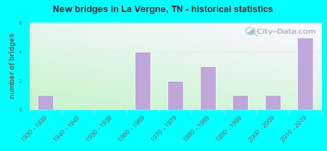
- New bridges - historical statistics
- 11930-1939
- 41960-1969
- 21970-1979
- 31980-1989
- 11990-1999
- 12000-2009
- 52010-2019

- Reconstructed bridges - Historical Statistics
- 21990-1999
- 12000-2009


- Bridge Condition - Superstructure
- 50.0%Good
- 50.0%Satisfactory

- Bridge Condition - Channel
- 42.9%Good
- 35.7%Satisfactory
- 21.4%Fair

- Bridge Condition - Culverts
- 57.1%Good
- 28.6%Satisfactory
- 14.3%Fair
Find on map >> Show street view
Structure Number: 75010570001, Location: 3.5 MI NW JCT SR1&SR266 (Lat: 36.021800, Lng: -86.590633), Route carried "on" structure: City street 1057, Year Built: 1983, Year Reconstructed: 2013, Status: Open, Structure Length: 6.98m (22.90ft), Average Daily Traffic: 27,954 (year 2020), Truck Traffic: 4%, Average Future Daily Traffic: 49,920 (year 2041), Design Load: HL 93, Features Intersected: CSX RAILROAD
Minimum Vertical Clearance: 30+ m (98+ ft), Kilometerpoint: 0.499, Lanes on structure: 5, Owner: City or Municipal Highway Agency, Approaching Roadway Width: 19.5m (64.0ft), Skew: 3 degrees, Material/Design: Prestressed concrete continuous, Design/Construction: Box Beam or Girders - Multiple, Number Of Spans In Main Unit: 3, Length of Maximum Span: 25.0m (82.0ft), Curb or Sidewalk Widths: Left: 1.5m (4.9ft), Right: 1.5m (4.9ft), Curb-To-Curb Width: 19.5m (64.0ft), Out-to-Out Width: 23.2m (76.1ft)
Condition: Deck: Good, Superstructure: Satisfactory, Substructure: Good, Operating Rating: 39.5 metric tons, Method Used To Determine Operating Rating: Load and Resistance Factor Rating (LRFR) rating reported by rating factor(RF) method using HL-93 loadings, Inventory Rating: 32.4 metric tons, Method Used To Determine Inventory Rating: Load and Resistance Factor Rating (LRFR) rating reported by rating factor(RF) method using HL-93 loadings, Structural Evaluation: Equal to present minimum criteria, Deck Geometry: Meets minimum limits, Underclear: Equal to present minimum criteria, Approach Roadway Alignment: Equal to present desirable criteria, Designated Inspection Frequency: Every 24 months, Inspection Date: June 2020, Deck Structure Type: Concrete Cast-file-Place, Wearing Surface/Protective System: Wearing Surface: Monolithic Concrete, Deck Protection: Epoxy Coated Reinforcing
Find on map >> Show street view
Structure Number: 75010590005, Location: 1.5 MI SW JCT SR1&SR266 (Lat: 35.981297, Lng: -86.543564), Route carried "on" structure: County highway 1059, Year Built: 2000, Status: Open, Structure Length: 1.46m (4.79ft), Average Daily Traffic: 11,633 (year 2020), Truck Traffic: 4%, Average Future Daily Traffic: 22,000 (year 2041), Design Load: HS 20, Features Intersected: ROCK SPRINGS BRANCH
Minimum Vertical Clearance: 30+ m (98+ ft), Kilometerpoint: 5.456, Lanes on structure: 4, Owner: City or Municipal Highway Agency, Approaching Roadway Width: 14.0m (45.9ft), Material/Design: Concrete continuous, Design/Construction: Culvert, Number Of Spans In Main Unit: 3, Length of Maximum Span: 4.6m (15.1ft), Curb or Sidewalk Widths: Left: 1.5m (4.9ft), Right: 1.5m (4.9ft), Curb-To-Curb Width: 17.1m (56.1ft), Out-to-Out Width: 23.5m (77.1ft)
Condition: Channel: Good, Culverts: Satisfactory, Operating Rating: 44.1 metric tons, Method Used To Determine Operating Rating: Assigned rating based on Load Factor Design (LFD) reported in metric tons, Inventory Rating: 32.4 metric tons, Method Used To Determine Inventory Rating: Assigned rating based on Load Factor Design (LFD) reported in metric tons, Structural Evaluation: Equal to present minimum criteria, Deck Geometry: Somewhat better than minimum adequacy, Waterway Adequacy: Better than present minimum criteria, Approach Roadway Alignment: Equal to present desirable criteria, Designated Inspection Frequency: Every 24 months, Inspection Date: June 2020, Deck Structure Type: Concrete Cast-file-Place, Wearing Surface/Protective System: Wearing Surface: Monolithic Concrete, Deck Protection: Epoxy Coated Reinforcing
Find on map >> Show street view
Structure Number: 75040440001, Location: 1.3 MI NW JCT SR1&SR266 (Lat: 36.015781, Lng: -86.542322), Route carried "on" structure: City street 4044, Year Built: 1985, Status: Open, Structure Length: 0.67m (2.20ft), Average Daily Traffic: 12,231 (year 2020), Truck Traffic: 3%, Average Future Daily Traffic: 21,008 (year 2040), Design Load: HS 20, Features Intersected: FINCH BRANCH
Minimum Vertical Clearance: 30+ m (98+ ft), Kilometerpoint: 0.604, Lanes on structure: 2, Owner: City or Municipal Highway Agency, Approaching Roadway Width: 6.4m (21.0ft), Material/Design: Concrete continuous, Design/Construction: Culvert, Number Of Spans In Main Unit: 2, Length of Maximum Span: 3.0m (9.8ft), Curb-To-Curb Width: 7.9m (25.9ft), Out-to-Out Width: 8.5m (27.9ft)
Condition: Channel: Satisfactory, Culverts: Good, Operating Rating: 74.7 metric tons, Method Used To Determine Operating Rating: Load Factor (LF), Inventory Rating: 32.4 metric tons, Method Used To Determine Inventory Rating: Load Factor (LF), Structural Evaluation: Better than present minimum criteria, Deck Geometry: High priority of replacement, Waterway Adequacy: Better than present minimum criteria, Approach Roadway Alignment: Equal to present desirable criteria, Length Of Structure Improvement: 0.67m (2.20ft), Designated Inspection Frequency: Every 24 months, Inspection Date: June 2020, Bridge Improvement Cost: $103,000, Roadway Improvement Cost: $11,000, Total Project Cost: $155,000 ( Estimate for 2020), Deck Structure Type: Concrete Cast-file-Place, Wearing Surface/Protective System: Wearing Surface: Bituminous
Find on map >> Show street view
Structure Number: 750A6030001, Location: 0.5 MI SE JCT I24&SR266 (Lat: 35.967961, Lng: -86.566131), Route carried "on" structure: City street 603, Year Built: 1968, Status: Open, Structure Length: 1.55m (5.09ft), Average Daily Traffic: 20 (year 2022), Truck Traffic: 2%, Average Future Daily Traffic: 32 (year 2041), Design Load: HS 20, Features Intersected: ROCK SPRINGS BRANCH
Minimum Vertical Clearance: 30+ m (98+ ft), Kilometerpoint: 0.011, Lanes on structure: 2, Owner: City or Municipal Highway Agency, Approaching Roadway Width: 6.7m (22.0ft), Skew: 3 degrees, Material/Design: Concrete continuous, Design/Construction: Culvert, Number Of Spans In Main Unit: 4, Length of Maximum Span: 3.0m (9.8ft), Curb-To-Curb Width: 8.0m (26.2ft), Out-to-Out Width: 9.4m (30.8ft)
Condition: Channel: Satisfactory, Culverts: Fair, Operating Rating: 52.2 metric tons, Method Used To Determine Operating Rating: Load Factor (LF), Inventory Rating: 32.4 metric tons, Method Used To Determine Inventory Rating: Load Factor (LF), Structural Evaluation: Somewhat better than minimum adequacy, Deck Geometry: Equal to present minimum criteria, Waterway Adequacy: Better than present minimum criteria, Approach Roadway Alignment: Equal to present desirable criteria, Designated Inspection Frequency: Every 24 months, Inspection Date: June 2020, Deck Structure Type: Concrete Cast-file-Place, Wearing Surface/Protective System: Wearing Surface: Bituminous
Find on map >> Show street view
Structure Number: 750A6070001, Location: INDUSTRIAL ST NEAR WALDON (Lat: 35.998153, Lng: -86.595936), Route carried "on" structure: City street 607, Year Built: 1970, Year Reconstructed: 2002, Status: Open, Structure Length: 1.37m (4.49ft), Average Daily Traffic: 9,650 (year 2022), Truck Traffic: 2%, Average Future Daily Traffic: 15,440 (year 2041), Features Intersected: E BRANCH HURRICANE CREEK
Minimum Vertical Clearance: 30+ m (98+ ft), Kilometerpoint: 0.064, Lanes on structure: 3, Owner: City or Municipal Highway Agency, Approaching Roadway Width: 15.8m (51.8ft), Skew: 3 degrees, Material/Design: Concrete continuous, Design/Construction: Culvert, Number Of Spans In Main Unit: 3, Length of Maximum Span: 4.3m (14.1ft), Curb-To-Curb Width: 32.9m (107.9ft), Out-to-Out Width: 33.5m (109.9ft)
Condition: Channel: Satisfactory, Culverts: Satisfactory, Operating Rating: 89.1 metric tons, Method Used To Determine Operating Rating: Field evaluation and documented engineering judgment, Inventory Rating: 32.4 metric tons, Method Used To Determine Inventory Rating: Field evaluation and documented engineering judgment, Structural Evaluation: Equal to present minimum criteria, Deck Geometry: Superior to present desirable criteria, Waterway Adequacy: Better than present minimum criteria, Approach Roadway Alignment: Equal to present desirable criteria, Designated Inspection Frequency: Every 24 months, Inspection Date: June 2020
Find on map >> Show street view
Structure Number: 750A6100003, Location: ON FIRESTONE PARKWAY (Lat: 36.005103, Lng: -86.603514), Route carried "on" structure: City street 2, Year Built: 1974, Status: Open, Structure Length: 1.01m (3.31ft), Average Daily Traffic: 8,339 (year 2020), Truck Traffic: 4%, Average Future Daily Traffic: 15,184 (year 2041), Design Load: HS 20, Features Intersected: E BRANCH HURRICANE CREEK, Facility Carried by Structure: NFA B438
Minimum Vertical Clearance: 30+ m (98+ ft), Kilometerpoint: 0.756, Lanes on structure: 2, Owner: City or Municipal Highway Agency, Approaching Roadway Width: 9.8m (32.2ft), Material/Design: Concrete continuous, Design/Construction: Culvert, Number Of Spans In Main Unit: 3, Length of Maximum Span: 3.0m (9.8ft)
Condition: Channel: Good, Culverts: Fair, Operating Rating: 54.9 metric tons, Method Used To Determine Operating Rating: Load Factor (LF), Inventory Rating: 32.4 metric tons, Method Used To Determine Inventory Rating: Load Factor (LF), Structural Evaluation: Somewhat better than minimum adequacy, Waterway Adequacy: Better than present minimum criteria, Approach Roadway Alignment: Equal to present desirable criteria, Designated Inspection Frequency: Every 24 months, Inspection Date: June 2020
Find on map >> Show street view
Structure Number: 750A7340001, Location: SUN DR.NEAR WALDRON RD. (Lat: 36.000250, Lng: -86.595344), Route carried "on" structure: City street 734, Year Built: 1982, Status: Open, Structure Length: 1.46m (4.79ft), Average Daily Traffic: 9,990 (year 2022), Truck Traffic: 2%, Average Future Daily Traffic: 15,984 (year 2040), Design Load: HS 20, Features Intersected: E BRANCH HURRICANE CREEK
Minimum Vertical Clearance: 30+ m (98+ ft), Kilometerpoint: 0.089, Lanes on structure: 2, Owner: City or Municipal Highway Agency, Approaching Roadway Width: 15.8m (51.8ft), Material/Design: Concrete continuous, Design/Construction: Culvert, Number Of Spans In Main Unit: 3, Length of Maximum Span: 4.6m (15.1ft), Curb-To-Curb Width: 15.8m (51.8ft), Out-to-Out Width: 17.1m (56.1ft)
Condition: Channel: Good, Culverts: Good, Operating Rating: 53.1 metric tons, Method Used To Determine Operating Rating: Load Factor (LF), Inventory Rating: 32.4 metric tons, Method Used To Determine Inventory Rating: Load Factor (LF), Structural Evaluation: Better than present minimum criteria, Deck Geometry: Superior to present desirable criteria, Waterway Adequacy: Equal to present minimum criteria, Approach Roadway Alignment: Equal to present desirable criteria, Designated Inspection Frequency: Every 24 months, Inspection Date: June 2020, Deck Structure Type: Concrete Cast-file-Place, Wearing Surface/Protective System: Wearing Surface: Bituminous
Find on map >> Show street view
Structure Number: 750B9690001, Location: 2.8 MI NW JCT SR1&SR266 (Lat: 36.028667, Lng: -86.570333), Route carried "on" structure: City street 706, Year Built: 1990, Status: Open, Structure Length: 0.67m (2.20ft), Average Daily Traffic: 920 (year 2022), Truck Traffic: 1%, Average Future Daily Traffic: 1,472 (year 2040), Design Load: HS 20, Features Intersected: DRAINAGE DITCH
Minimum Vertical Clearance: 30+ m (98+ ft), Kilometerpoint: 0.451, Lanes on structure: 2, Owner: City or Municipal Highway Agency, Approaching Roadway Width: 6.7m (22.0ft), Material/Design: Concrete continuous, Design/Construction: Culvert, Number Of Spans In Main Unit: 2, Length of Maximum Span: 3.0m (9.8ft)
Condition: Channel: Satisfactory, Culverts: Good, Operating Rating: 54.0 metric tons, Method Used To Determine Operating Rating: Field evaluation and documented engineering judgment, Inventory Rating: 32.4 metric tons, Method Used To Determine Inventory Rating: Field evaluation and documented engineering judgment, Structural Evaluation: Better than present minimum criteria, Waterway Adequacy: Better than present minimum criteria, Approach Roadway Alignment: Equal to present desirable criteria, Designated Inspection Frequency: Every 24 months, Inspection Date: June 2020
Find on map >> Show street view
Structure Number: 750E9190001, Location: 0.4 MI NE OF JCT SR1&E919 (Lat: 36.025258, Lng: -86.579986), Route carried "on" structure: City street 101, Year Built: 2010, Status: Open, Structure Length: 1.37m (4.49ft), Average Daily Traffic: 210 (year 2022), Truck Traffic: 1%, Average Future Daily Traffic: 336 (year 2041), Design Load: HS 20, Features Intersected: BRANCH, Facility Carried by Structure: NFA A002
Minimum Vertical Clearance: 30+ m (98+ ft), Kilometerpoint: 0.595, Lanes on structure: 2, Owner: City or Municipal Highway Agency, Approaching Roadway Width: 12.3m (40.4ft), Skew: 4 degrees, Material/Design: Concrete continuous, Design/Construction: Culvert, Number Of Spans In Main Unit: 3, Length of Maximum Span: 5.5m (18.0ft), Curb-To-Curb Width: 20.0m (65.6ft), Out-to-Out Width: 20.0m (65.6ft)
Condition: Channel: Good, Culverts: Satisfactory, Operating Rating: 44.1 metric tons, Method Used To Determine Operating Rating: Assigned ratings based on Load and Resistance Factor Design (LRFD) reported by rating factor (RF) using HL93 loadings, Inventory Rating: 32.4 metric tons, Method Used To Determine Inventory Rating: Assigned ratings based on Load and Resistance Factor Design (LRFD) reported by rating factor (RF) using HL93 loadings, Structural Evaluation: Equal to present minimum criteria, Deck Geometry: Superior to present desirable criteria, Waterway Adequacy: Better than present minimum criteria, Approach Roadway Alignment: Equal to present desirable criteria, Designated Inspection Frequency: Every 24 months, Inspection Date: June 2020, Deck Structure Type: Concrete Cast-file-Place, Wearing Surface/Protective System: Wearing Surface: Bituminous
Find on map >> Show street view
Structure Number: 750E9190003, Location: 0.9 MI NE OF JCT SR1&E919 (Lat: 36.031058, Lng: -86.570894), Route carried "on" structure: City street 101, Year Built: 2010, Status: Open, Structure Length: 1.82m (5.97ft), Average Daily Traffic: 210 (year 2022), Truck Traffic: 1%, Average Future Daily Traffic: 336 (year 2041), Design Load: HS 20, Features Intersected: BRANCH, Facility Carried by Structure: NFA A002
Minimum Vertical Clearance: 30+ m (98+ ft), Kilometerpoint: 1.666, Lanes on structure: 2, Owner: City or Municipal Highway Agency, Approaching Roadway Width: 12.7m (41.7ft), Skew: 2 degrees, Material/Design: Concrete continuous, Design/Construction: Culvert, Number Of Spans In Main Unit: 3, Length of Maximum Span: 2.7m (8.9ft), Curb-To-Curb Width: 30.5m (100.1ft), Out-to-Out Width: 30.5m (100.1ft)
Condition: Channel: Fair, Culverts: Satisfactory, Operating Rating: 44.1 metric tons, Method Used To Determine Operating Rating: Assigned ratings based on Load and Resistance Factor Design (LRFD) reported by rating factor (RF) using HL93 loadings, Inventory Rating: 32.4 metric tons, Method Used To Determine Inventory Rating: Assigned ratings based on Load and Resistance Factor Design (LRFD) reported by rating factor (RF) using HL93 loadings, Structural Evaluation: Equal to present minimum criteria, Deck Geometry: Superior to present desirable criteria, Waterway Adequacy: Better than present minimum criteria, Approach Roadway Alignment: Equal to present desirable criteria, Designated Inspection Frequency: Every 24 months, Inspection Date: June 2020, Deck Structure Type: Concrete Cast-file-Place, Wearing Surface/Protective System: Wearing Surface: Bituminous
Find on map >> Show street view
Structure Number: 750E9190005, Location: 1.7 MI NE OF JCT SR1&E919 (Lat: 36.033103, Lng: -86.568853), Route carried "on" structure: City street 101, Year Built: 2010, Status: Open, Structure Length: 1.01m (3.31ft), Average Daily Traffic: 210 (year 2022), Truck Traffic: 1%, Average Future Daily Traffic: 336 (year 2040), Design Load: HS 20, Features Intersected: BRANCH, Facility Carried by Structure: NFA A002
Minimum Vertical Clearance: 30+ m (98+ ft), Kilometerpoint: 1.963, Lanes on structure: 2, Owner: City or Municipal Highway Agency, Approaching Roadway Width: 10.7m (35.1ft), Material/Design: Concrete continuous, Design/Construction: Culvert, Number Of Spans In Main Unit: 3, Length of Maximum Span: 3.0m (9.8ft), Curb-To-Curb Width: 14.3m (46.9ft), Out-to-Out Width: 14.3m (46.9ft)
Condition: Channel: Fair, Culverts: Good, Operating Rating: 44.1 metric tons, Method Used To Determine Operating Rating: Assigned ratings based on Load and Resistance Factor Design (LRFD) reported by rating factor (RF) using HL93 loadings, Inventory Rating: 32.4 metric tons, Method Used To Determine Inventory Rating: Assigned ratings based on Load and Resistance Factor Design (LRFD) reported by rating factor (RF) using HL93 loadings, Structural Evaluation: Better than present minimum criteria, Deck Geometry: Superior to present desirable criteria, Waterway Adequacy: Better than present minimum criteria, Approach Roadway Alignment: Equal to present desirable criteria, Designated Inspection Frequency: Every 24 months, Inspection Date: June 2020, Deck Structure Type: Concrete Cast-file-Place, Wearing Surface/Protective System: Wearing Surface: Bituminous
Find on map >> Show street view
Structure Number: 750E9190007, Location: 2 MI NE OF JCT SR1&E919 (Lat: 36.033450, Lng: -86.567003), Route carried "on" structure: City street 101, Year Built: 2010, Status: Open, Structure Length: 1.01m (3.31ft), Average Daily Traffic: 210 (year 2022), Truck Traffic: 1%, Average Future Daily Traffic: 336 (year 2040), Design Load: HS 20, Features Intersected: BRANCH, Facility Carried by Structure: NFA A002
Minimum Vertical Clearance: 30+ m (98+ ft), Kilometerpoint: 2.124, Lanes on structure: 2, Owner: City or Municipal Highway Agency, Approaching Roadway Width: 14.5m (47.6ft), Material/Design: Concrete continuous, Design/Construction: Culvert, Number Of Spans In Main Unit: 3, Length of Maximum Span: 3.0m (9.8ft), Curb-To-Curb Width: 16.2m (53.1ft), Out-to-Out Width: 16.2m (53.1ft)
Condition: Channel: Good, Culverts: Good, Operating Rating: 44.1 metric tons, Method Used To Determine Operating Rating: Assigned ratings based on Load and Resistance Factor Design (LRFD) reported by rating factor (RF) using HL93 loadings, Inventory Rating: 32.4 metric tons, Method Used To Determine Inventory Rating: Assigned ratings based on Load and Resistance Factor Design (LRFD) reported by rating factor (RF) using HL93 loadings, Structural Evaluation: Better than present minimum criteria, Deck Geometry: Superior to present desirable criteria, Waterway Adequacy: Better than present minimum criteria, Approach Roadway Alignment: Equal to present desirable criteria, Designated Inspection Frequency: Every 24 months, Inspection Date: June 2020, Deck Structure Type: Concrete Cast-file-Place, Wearing Surface/Protective System: Wearing Surface: Bituminous
Find on map >> Show street view
Structure Number: 75F00490001, Location: 2.4 MI NW JCT I24&SR266 (Lat: 36.002683, Lng: -86.596033), Route carried "on" structure: City street 1057, Year Built: 2014, Status: Open, Structure Length: 1.74m (5.71ft), Average Daily Traffic: 27,954 (year 2020), Truck Traffic: 4%, Average Future Daily Traffic: 49,920 (year 2040), Design Load: HL 93, Features Intersected: HURRICANE CREEK
Minimum Vertical Clearance: 30+ m (98+ ft), Kilometerpoint: 2.712, Lanes on structure: 50, Owner: City or Municipal Highway Agency, Approaching Roadway Width: 26.8m (87.9ft), Material/Design: Concrete continuous, Design/Construction: Culvert, Number Of Spans In Main Unit: 5, Length of Maximum Span: 5.5m (18.0ft), Curb or Sidewalk Widths: Left: 1.5m (4.9ft), Right: 1.5m (4.9ft), Curb-To-Curb Width: 26.8m (87.9ft), Out-to-Out Width: 30.5m (100.1ft)
Condition: Channel: Good, Culverts: Good, Operating Rating: 54.1 metric tons, Method Used To Determine Operating Rating: Assigned ratings based on Load and Resistance Factor Design (LRFD) reported by rating factor (RF) using HL93 loadings, Inventory Rating: 32.4 metric tons, Method Used To Determine Inventory Rating: Assigned ratings based on Load and Resistance Factor Design (LRFD) reported by rating factor (RF) using HL93 loadings, Structural Evaluation: Better than present minimum criteria, Deck Geometry: High priority of replacement, Waterway Adequacy: Better than present minimum criteria, Approach Roadway Alignment: Equal to present desirable criteria, Designated Inspection Frequency: Every 24 months, Inspection Date: June 2020
Find on map >> Show street view
Structure Number: 75F00490003, Location: 2.2 MI NW JCT I24&SR266 (Lat: 35.997683, Lng: -86.596683), Route carried "on" structure: City street 1057, Year Built: 1968, Status: Open, Structure Length: 1.37m (4.49ft), Average Daily Traffic: 27,954 (year 2020), Truck Traffic: 4%, Average Future Daily Traffic: 49,920 (year 2040), Design Load: HS 20, Features Intersected: HURRICANE CREEK
Minimum Vertical Clearance: 30+ m (98+ ft), Kilometerpoint: 3.251, Lanes on structure: 4, Owner: City or Municipal Highway Agency, Approaching Roadway Width: 19.5m (64.0ft), Skew: 3 degrees, Material/Design: Concrete continuous, Design/Construction: Culvert, Number Of Spans In Main Unit: 3, Length of Maximum Span: 3.7m (12.1ft)
Condition: Channel: Satisfactory, Culverts: Good, Operating Rating: 48.6 metric tons, Method Used To Determine Operating Rating: Load Factor (LF), Inventory Rating: 28.8 metric tons, Method Used To Determine Inventory Rating: Load Factor (LF), Structural Evaluation: Better than present minimum criteria, Waterway Adequacy: Better than present minimum criteria, Approach Roadway Alignment: Equal to present desirable criteria, Designated Inspection Frequency: Every 24 months, Inspection Date: June 2020
Find on map >> Show street view
Structure Number: 75I00240003, Location: 2.1 MI NW JCT I24&SR266 (Lat: 35.995000, Lng: -86.596650), Route carried "on" structure: City street 1057, Year Built: 1968, Year Reconstructed: 2002, Status: Open, Structure Length: 6.55m (21.49ft), Average Daily Traffic: 27,954 (year 2020), Truck Traffic: 4%, Average Future Daily Traffic: 49,920 (year 2040), Design Load: H 20, Features Intersected: WALDRON RD / I24
Minimum Vertical Clearance: 30+ m (98+ ft), Kilometerpoint: 3.492, Lanes on structure: 4, Lanes under structure: 8, Owner: State Highway Agency, Approaching Roadway Width: 23.2m (76.1ft), Skew: 3 degrees, Material/Design: Steel continuous, Design/Construction: Stringer/Multi-beam, Number Of Spans In Main Unit: 2, Length of Maximum Span: 32.0m (105.0ft), Curb-To-Curb Width: 23.2m (76.1ft), Out-to-Out Width: 26.8m (87.9ft)
Condition: Deck: Good, Superstructure: Good, Substructure: Good, Operating Rating: 56.7 metric tons, Method Used To Determine Operating Rating: Load Factor (LF), Inventory Rating: 32.4 metric tons, Method Used To Determine Inventory Rating: Load Factor (LF), Structural Evaluation: Better than present minimum criteria, Deck Geometry: Superior to present desirable criteria, Underclear: Somewhat better than minimum adequacy, Approach Roadway Alignment: Equal to present desirable criteria, Designated Inspection Frequency: Every 24 months, Inspection Date: June 2020, Deck Structure Type: Concrete Cast-file-Place, Wearing Surface/Protective System: Wearing Surface: Monolithic Concrete, Deck Protection: Epoxy Coated Reinforcing
Find on map >> Show street view
Structure Number: 75I00240301, Location: JCT I-24 AND WALDRON RD. (Lat: 35.997000, Lng: -86.597250), Route carried "on" structure: Ramp Interstate 24, Year Built: 1969, Status: Open, Structure Length: 1.20m (3.94ft), Average Daily Traffic: 131,512 (year 2020), Truck Traffic: 13%, Average Future Daily Traffic: 16,400 (year 2040), Design Load: HS 20, Features Intersected: I-24 WEST RAMP / BRANCH
Minimum Vertical Clearance: 30+ m (98+ ft), Kilometerpoint: 1.963, Lanes on structure: 1, Base Highway Network: Yes, Owner: State Highway Agency, Approaching Roadway Width: 12.2m (40.0ft), Material/Design: Concrete continuous, Design/Construction: Culvert, Number Of Spans In Main Unit: 3, Length of Maximum Span: 3.7m (12.1ft)
Condition: Channel: Fair, Culverts: Good, Operating Rating: 77.4 metric tons, Method Used To Determine Operating Rating: Load Factor (LF), Inventory Rating: 32.4 metric tons, Method Used To Determine Inventory Rating: Load Factor (LF), Structural Evaluation: Better than present minimum criteria, Waterway Adequacy: Better than present minimum criteria, Approach Roadway Alignment: Equal to present desirable criteria, Designated Inspection Frequency: Every 24 months, Inspection Date: June 2020
Find on map >> Show street view
Structure Number: 75010590007, Location: 2.9 MI NW JCT SR 1& SR266 (Lat: 36.018350, Lng: -86.578400), Route carried "under" structure: City street 1059, Year Built: 1930, Structure Length: 0. m, Average Daily Traffic: 6,381 (year 2020), Truck Traffic: 4%, Features Intersected: CSX RR / FAU 1059, Facility Carried by Structure: CSX RR 349233P
Minimum Vertical Clearance: 3.97m (13.02ft), Kilometerpoint: 0.274, Lanes under structure: 2, Material/Design: Prestressed concrete, Design/Construction: Box Beam or Girders - Multiple, Length of Maximum Span: 7.3m (24.0ft)