Bridge Statistics for Kodiak, Alaska (AK)
Condition, Traffic, Stress, Structural Evaluation, Project Costs
- National Bridge Inventory (NBI) Statistics
- 15Number of bridges
- 338ft / 103mTotal length
- 9,740Total average daily traffic
- 1,114Total average daily truck traffic
- National Bridge Inventory (NBI) Registered Bridges for Kodiak
- No street view available for this location
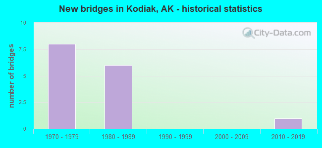
- New bridges - historical statistics
- 81970-1979
- 61980-1989
- 12010-2019

- Bridge Condition - Deck
- 15.4%Very good
- 69.2%Good
- 15.4%Satisfactory

- Bridge Condition - Superstructure
- 7.7%Very good
- 15.4%Good
- 61.5%Satisfactory
- 15.4%Poor

- Bridge Condition - Substructure
- 7.7%Very good
- 53.8%Good
- 30.8%Satisfactory
- 7.7%Fair

- Bridge Condition - Channel
- 14.3%Excellent
- 21.4%Very good
- 50.0%Good
- 7.1%Satisfactory
- 7.1%Fair
Find on map >> Show street view
Structure Number: 208, Location: MILE POINT 25.7 (Lat: 57.618047, Lng: -152.324300), Route carried "on" structure: State highway 391, Year Built: 1974, Status: Open, Structure Length: 1.92m (6.30ft), Average Daily Traffic: 166 (year 2018), Truck Traffic: 11%, Average Future Daily Traffic: 300 (year 2035), Design Load: HS 20, Features Intersected: ROSLYN CREEK, Facility Carried by Structure: CHINIAK HIGHWAY
Minimum Vertical Clearance: 30+ m (98+ ft), Kilometerpoint: 41.313, Lanes on structure: 2, Owner: State Highway Agency, Approaching Roadway Width: 8.5m (27.9ft), Material/Design: Prestressed concrete, Design/Construction: Tee Beam, Number Of Spans In Main Unit: 2, Length of Maximum Span: 9.4m (30.8ft), Curb-To-Curb Width: 7.2m (23.6ft), Out-to-Out Width: 8.5m (27.9ft)
Condition: Deck: Good, Superstructure: Satisfactory, Substructure: Good, Channel: Good, Operating Rating: 84.6 metric tons, Method Used To Determine Operating Rating: Load Factor (LF), Inventory Rating: 38.6 metric tons, Method Used To Determine Inventory Rating: Load Factor (LF), Structural Evaluation: Equal to present minimum criteria, Deck Geometry: Meets minimum limits, Waterway Adequacy: Equal to present desirable criteria, Approach Roadway Alignment: Equal to present desirable criteria, Designated Inspection Frequency: Every 24 months, Inspection Date: September 2020, Deck Structure Type: Other, Wearing Surface/Protective System: Wearing Surface: Bituminous, Membrane: Preformed Fabric
Find on map >> Show street view
Structure Number: 284, Location: MILE POINT 9.4 (Lat: 57.640964, Lng: -152.513111), Route carried "on" structure: State highway 391, Year Built: 1974, Status: Open, Structure Length: 4.78m (15.68ft), Average Daily Traffic: 600 (year 2020), Truck Traffic: 15%, Average Future Daily Traffic: 1,200 (year 2039), Design Load: HS 20, Features Intersected: AMERICAN RIVER, Facility Carried by Structure: CHINIAK HIGHWAY
Minimum Vertical Clearance: 30+ m (98+ ft), Kilometerpoint: 15.118, Lanes on structure: 2, Owner: State Highway Agency, Approaching Roadway Width: 10.1m (33.1ft), Material/Design: Prestressed concrete, Design/Construction: Tee Beam, Number Of Spans In Main Unit: 5, Length of Maximum Span: 9.4m (30.8ft), Curb-To-Curb Width: 7.3m (24.0ft), Out-to-Out Width: 8.5m (27.9ft)
Condition: Deck: Good, Superstructure: Satisfactory, Substructure: Good, Channel: Good, Operating Rating: 84.2 metric tons, Method Used To Determine Operating Rating: Load Factor (LF), Inventory Rating: 38.6 metric tons, Method Used To Determine Inventory Rating: Load Factor (LF), Structural Evaluation: Equal to present minimum criteria, Deck Geometry: Meets minimum limits, Waterway Adequacy: Equal to present desirable criteria, Approach Roadway Alignment: Equal to present desirable criteria, Designated Inspection Frequency: Every 24 months, Inspection Date: September 2020, Deck Structure Type: Other, Wearing Surface/Protective System: Wearing Surface: Bituminous, Membrane: Preformed Fabric
Find on map >> Show street view
Structure Number: 286, Location: MILE POINT 17.7 (Lat: 57.594561, Lng: -152.479981), Route carried "on" structure: State highway 391, Year Built: 1974, Status: Open, Structure Length: 1.92m (6.30ft), Average Daily Traffic: 470 (year 2020), Truck Traffic: 15%, Average Future Daily Traffic: 1,300 (year 2039), Design Load: HS 20, Features Intersected: DEADMAN CREEK, Facility Carried by Structure: CHINIAK HIGHWAY
Minimum Vertical Clearance: 30+ m (98+ ft), Kilometerpoint: 28.429, Lanes on structure: 2, Owner: State Highway Agency, Approaching Roadway Width: 8.5m (27.9ft), Material/Design: Prestressed concrete, Design/Construction: Tee Beam, Number Of Spans In Main Unit: 2, Length of Maximum Span: 9.4m (30.8ft), Curb-To-Curb Width: 7.2m (23.6ft), Out-to-Out Width: 8.5m (27.9ft)
Condition: Deck: Good, Superstructure: Satisfactory, Substructure: Good, Channel: Good, Operating Rating: 84.2 metric tons, Method Used To Determine Operating Rating: Load Factor (LF), Inventory Rating: 38.6 metric tons, Method Used To Determine Inventory Rating: Load Factor (LF), Structural Evaluation: Equal to present minimum criteria, Deck Geometry: Meets minimum limits, Waterway Adequacy: Equal to present minimum criteria, Approach Roadway Alignment: Better than present minimum criteria, Designated Inspection Frequency: Every 24 months, Inspection Date: September 2020, Deck Structure Type: Other, Wearing Surface/Protective System: Wearing Surface: Bituminous, Membrane: Preformed Fabric
Find on map >> Show street view
Structure Number: 291, Location: MILE POINT 18.8 (Lat: 57.583547, Lng: -152.460089), Route carried "on" structure: State highway 391, Year Built: 1974, Status: Open, Structure Length: 2.87m (9.42ft), Average Daily Traffic: 470 (year 2020), Truck Traffic: 15%, Average Future Daily Traffic: 1,300 (year 2039), Design Load: HS 20, Features Intersected: KALSIN CREEK, Facility Carried by Structure: CHINIAK HIGHWAY
Minimum Vertical Clearance: 30+ m (98+ ft), Kilometerpoint: 30.299, Lanes on structure: 2, Owner: State Highway Agency, Approaching Roadway Width: 8.5m (27.9ft), Material/Design: Prestressed concrete, Design/Construction: Tee Beam, Number Of Spans In Main Unit: 3, Length of Maximum Span: 9.4m (30.8ft), Curb-To-Curb Width: 7.2m (23.6ft), Out-to-Out Width: 8.5m (27.9ft)
Condition: Deck: Good, Superstructure: Satisfactory, Substructure: Good, Channel: Good, Operating Rating: 84.3 metric tons, Method Used To Determine Operating Rating: Load Factor (LF), Inventory Rating: 38.6 metric tons, Method Used To Determine Inventory Rating: Load Factor (LF), Structural Evaluation: Equal to present minimum criteria, Deck Geometry: Meets minimum limits, Waterway Adequacy: Better than present minimum criteria, Approach Roadway Alignment: Equal to present desirable criteria, Designated Inspection Frequency: Every 24 months, Inspection Date: September 2020, Deck Structure Type: Other, Wearing Surface/Protective System: Wearing Surface: Bituminous, Membrane: Preformed Fabric
Find on map >> Show street view
Structure Number: 292, Location: MILE POINT 21.7 (Lat: 57.603997, Lng: -152.405456), Route carried "on" structure: State highway 391, Year Built: 1974, Status: Open, Structure Length: 2.87m (9.42ft), Average Daily Traffic: 166 (year 2018), Truck Traffic: 11%, Average Future Daily Traffic: 200 (year 2035), Design Load: HS 20, Features Intersected: MYRTLE CREEK, Facility Carried by Structure: CHINIAK HIGHWAY
Minimum Vertical Clearance: 30+ m (98+ ft), Kilometerpoint: 34.949, Lanes on structure: 2, Owner: State Highway Agency, Approaching Roadway Width: 8.5m (27.9ft), Material/Design: Prestressed concrete, Design/Construction: Tee Beam, Number Of Spans In Main Unit: 3, Length of Maximum Span: 9.4m (30.8ft), Curb-To-Curb Width: 7.2m (23.6ft), Out-to-Out Width: 8.5m (27.9ft)
Condition: Deck: Good, Superstructure: Satisfactory, Substructure: Satisfactory, Channel: Fair, Operating Rating: 84.6 metric tons, Method Used To Determine Operating Rating: Load Factor (LF), Inventory Rating: 38.6 metric tons, Method Used To Determine Inventory Rating: Load Factor (LF), Structural Evaluation: Equal to present minimum criteria, Deck Geometry: Meets minimum limits, Waterway Adequacy: Superior to present desirable criteria, Approach Roadway Alignment: Equal to present minimum criteria, Designated Inspection Frequency: Every 24 months, Inspection Date: September 2020, Deck Structure Type: Other, Wearing Surface/Protective System: Wearing Surface: Bituminous, Membrane: Preformed Fabric
Find on map >> Show street view
Structure Number: 983, Location: MILE POINT 7.5 (Lat: 57.816586, Lng: -152.625639), Route carried "on" structure: State highway 391, Year Built: 1974, Status: Open, Structure Length: 1.92m (6.30ft), Average Daily Traffic: 90 (year 2020), Truck Traffic: 6%, Average Future Daily Traffic: 140 (year 2039), Design Load: HS 20, Features Intersected: RED CLOUD RIVER, Facility Carried by Structure: ANTON LARSEN BAY
Minimum Vertical Clearance: 30+ m (98+ ft), Kilometerpoint: 12.012, Lanes on structure: 2, Owner: State Highway Agency, Approaching Roadway Width: 8.5m (27.9ft), Material/Design: Prestressed concrete, Design/Construction: Tee Beam, Number Of Spans In Main Unit: 2, Length of Maximum Span: 9.4m (30.8ft), Curb-To-Curb Width: 7.1m (23.3ft), Out-to-Out Width: 8.5m (27.9ft)
Condition: Deck: Good, Superstructure: Satisfactory, Substructure: Fair, Channel: Good, Operating Rating: 84.6 metric tons, Method Used To Determine Operating Rating: Load Factor (LF), Inventory Rating: 38.6 metric tons, Method Used To Determine Inventory Rating: Load Factor (LF), Structural Evaluation: Somewhat better than minimum adequacy, Deck Geometry: Somewhat better than minimum adequacy, Waterway Adequacy: Equal to present desirable criteria, Approach Roadway Alignment: Equal to present minimum criteria, Designated Inspection Frequency: Every 24 months, Inspection Date: September 2020, Deck Structure Type: Other, Wearing Surface/Protective System: Wearing Surface: Bituminous, Membrane: Preformed Fabric
Find on map >> Show street view
Structure Number: 989, Location: MILE POINT 13.5 (Lat: 57.709164, Lng: -152.568464), Route carried "on" structure: State highway 391, Year Built: 1980, Status: Open, Structure Length: 2.33m (7.64ft), Average Daily Traffic: 2,530 (year 2020), Truck Traffic: 11%, Average Future Daily Traffic: 4,950 (year 2039), Design Load: HS 20, Features Intersected: SARGENT CREEK, Facility Carried by Structure: REZANOF DRIVE
Minimum Vertical Clearance: 30+ m (98+ ft), Kilometerpoint: 21.757, Lanes on structure: 2, Owner: State Highway Agency, Approaching Roadway Width: 10.1m (33.1ft), Material/Design: Prestressed concrete, Design/Construction: Tee Beam, Number Of Spans In Main Unit: 2, Length of Maximum Span: 11.3m (37.1ft), Curb-To-Curb Width: 8.5m (27.9ft), Out-to-Out Width: 9.0m (29.5ft)
Condition: Deck: Satisfactory, Superstructure: Poor, Substructure: Satisfactory, Channel: Very good, Operating Rating: 87.8 metric tons, Method Used To Determine Operating Rating: Load Factor (LF), Inventory Rating: 40.5 metric tons, Method Used To Determine Inventory Rating: Load Factor (LF), Structural Evaluation: Meets minimum limits, Deck Geometry: Meets minimum limits, Waterway Adequacy: Equal to present desirable criteria, Approach Roadway Alignment: Better than present minimum criteria, Designated Inspection Frequency: Every 24 months, Inspection Date: September 2020, Deck Structure Type: Concrete Precast Panels, Wearing Surface/Protective System: Wearing Surface: Bituminous, Membrane: Preformed Fabric
Find on map >> Show street view
Structure Number: 99, Location: MILE POINT 13.7 (Lat: 57.706322, Lng: -152.571353), Route carried "on" structure: State highway 391, Year Built: 1980, Status: Open, Structure Length: 3.47m (11.38ft), Average Daily Traffic: 1,770 (year 2020), Truck Traffic: 15%, Average Future Daily Traffic: 2,700 (year 2039), Design Load: HS 20, Features Intersected: RUSSIAN RIVER, Facility Carried by Structure: REZANOF DRIVE
Minimum Vertical Clearance: 30+ m (98+ ft), Kilometerpoint: 22.120, Lanes on structure: 2, Owner: State Highway Agency, Approaching Roadway Width: 9.1m (29.9ft), Material/Design: Prestressed concrete, Design/Construction: Tee Beam, Number Of Spans In Main Unit: 3, Length of Maximum Span: 11.3m (37.1ft), Curb-To-Curb Width: 7.3m (24.0ft), Out-to-Out Width: 9.0m (29.5ft)
Condition: Deck: Good, Superstructure: Poor, Substructure: Satisfactory, Channel: Good, Operating Rating: 87.8 metric tons, Method Used To Determine Operating Rating: Load Factor (LF), Inventory Rating: 40.5 metric tons, Method Used To Determine Inventory Rating: Load Factor (LF), Structural Evaluation: Meets minimum limits, Deck Geometry: Meets minimum limits, Waterway Adequacy: Equal to present desirable criteria, Approach Roadway Alignment: Equal to present desirable criteria, Designated Inspection Frequency: Every 24 months, Inspection Date: September 2020, Deck Structure Type: Concrete Precast Panels, Wearing Surface/Protective System: Wearing Surface: Bituminous, Membrane: Preformed Fabric
Find on map >> Show street view
Structure Number: 992, Location: MILE POINT 0.7 (Lat: 57.696308, Lng: -152.560664), Route carried "on" structure: State highway 391, Year Built: 1980, Status: Open, Structure Length: 3.47m (11.38ft), Average Daily Traffic: 600 (year 2020), Truck Traffic: 15%, Average Future Daily Traffic: 1,200 (year 2039), Design Load: HS 20, Features Intersected: SALONIE CREEK NO. 1, Facility Carried by Structure: CHINIAK HIGHWAY
Minimum Vertical Clearance: 30+ m (98+ ft), Kilometerpoint: 1.115, Lanes on structure: 2, Owner: State Highway Agency, Approaching Roadway Width: 8.8m (28.9ft), Material/Design: Prestressed concrete, Design/Construction: Tee Beam, Number Of Spans In Main Unit: 3, Length of Maximum Span: 11.6m (38.1ft), Curb-To-Curb Width: 8.2m (26.9ft), Out-to-Out Width: 9.4m (30.8ft)
Condition: Deck: Satisfactory, Superstructure: Satisfactory, Substructure: Satisfactory, Channel: Good, Operating Rating: 87.8 metric tons, Method Used To Determine Operating Rating: Load Factor (LF), Inventory Rating: 40.5 metric tons, Method Used To Determine Inventory Rating: Load Factor (LF), Structural Evaluation: Equal to present minimum criteria, Deck Geometry: Somewhat better than minimum adequacy, Waterway Adequacy: Superior to present desirable criteria, Approach Roadway Alignment: Somewhat better than minimum adequacy, Designated Inspection Frequency: Every 24 months, Inspection Date: September 2020, Deck Structure Type: Other, Wearing Surface/Protective System: Wearing Surface: Bituminous, Membrane: Preformed Fabric
Find on map >> Show street view
Structure Number: 1189, Location: MILE POINT 0.1 (Lat: 57.788697, Lng: -152.397369), Route carried "on" structure: ServiceCounty highway NSP, Year Built: 1986, Status: Open, Structure Length: 38.33m (125.75ft), Average Daily Traffic: 1,970 (year 2020), Truck Traffic: 8%, Average Future Daily Traffic: 5,290 (year 2039), Design Load: HS 20, Features Intersected: KODIAK HARBOR CHANNEL, Facility Carried by Structure: NEAR ISLAND ROAD
Minimum Vertical Clearance: 30+ m (98+ ft), Kilometerpoint: 0.161, Lanes on structure: 2, Lanes under structure: 2, Owner: State Highway Agency, Approaching Roadway Width: 13.7m (44.9ft), Skew: 20 degrees, Navigation Control: Yes ( Vertical Clearance: 30.5m (100.1ft), Horizontal Clearance: 61.0m (200.1ft)), Material/Design: Steel continuous, Design/Construction: Stringer/Multi-beam, Number Of Spans In Main Unit: 4, Length of Maximum Span: 118.9m (390.1ft), Curb or Sidewalk Widths: Left: 2.7m (8.9ft), Right: 0.0m, Curb-To-Curb Width: 11.0m (36.1ft), Out-to-Out Width: 14.6m (47.9ft)
Condition: Deck: Very good, Superstructure: Good, Substructure: Good, Channel: Excellent, Operating Rating: 51.8 metric tons, Method Used To Determine Operating Rating: Load Factor (LF), Inventory Rating: 27.3 metric tons, Method Used To Determine Inventory Rating: Load Factor (LF), Structural Evaluation: Equal to present minimum criteria, Deck Geometry: Equal to present minimum criteria, Underclear: Superior to present desirable criteria, Waterway Adequacy: Superior to present desirable criteria, Approach Roadway Alignment: Superior to present desirable criteria, Designated Inspection Frequency: Every 24 months, Inspection Date: November 2021, Deck Structure Type: Concrete Cast-file-Place, Wearing Surface/Protective System: Wearing Surface: Monolithic Concrete, Deck Protection: Epoxy Coated Reinforcing
Find on map >> Show street view
Structure Number: 1274, Location: MILE POINT 7.2 (Lat: 57.841397, Lng: -152.445467), Route carried "on" structure: State highway 389, Year Built: 1972, Status: Open, Structure Length: 3.09m (10.14ft), Average Daily Traffic: 220 (year 2020), Truck Traffic: 8%, Average Future Daily Traffic: 320 (year 2039), Design Load: HS 20, Features Intersected: MONASHKA CREEK, Facility Carried by Structure: MONASHKA BAY ROAD
Minimum Vertical Clearance: 30+ m (98+ ft), Kilometerpoint: 11.565, Lanes on structure: 2, Owner: State Highway Agency, Approaching Roadway Width: 9.1m (29.9ft), Material/Design: Wood or Timber, Design/Construction: Stringer/Multi-beam, Number Of Spans In Main Unit: 4, Length of Maximum Span: 7.6m (24.9ft), Curb-To-Curb Width: 8.5m (27.9ft), Out-to-Out Width: 9.1m (29.9ft)
Condition: Deck: Good, Superstructure: Satisfactory, Substructure: Good, Channel: Very good, Operating Rating: 55.7 metric tons, Method Used To Determine Operating Rating: Load Factor (LF), Inventory Rating: 31.9 metric tons, Method Used To Determine Inventory Rating: Load Factor (LF), Structural Evaluation: Equal to present minimum criteria, Deck Geometry: Equal to present minimum criteria, Waterway Adequacy: Equal to present desirable criteria, Approach Roadway Alignment: Equal to present desirable criteria, Designated Inspection Frequency: Every 24 months, Inspection Date: September 2020, Deck Structure Type: Wood or Timber, Wearing Surface/Protective System: Wearing Surface: Wood or Timber
Find on map >> Show street view
Structure Number: 1425, Location: KODIAK (Lat: 57.787189, Lng: -152.402539), Route carried "on" structure: State highway 389, Year Built: 2016, Status: Open, Structure Length: 7.01m (23.00ft), Average Daily Traffic: 216 (year 2018), Truck Traffic: 6%, Average Future Daily Traffic: 250 (year 2035), Design Load: HL 93, Features Intersected: KODIAK CITY DOCK, Facility Carried by Structure: MARINE HWY ROUTE
Minimum Vertical Clearance: 30+ m (98+ ft), Kilometerpoint: 0.161, Lanes on structure: 2, Toll: On toll road, Owner: City or Municipal Highway Agency, Approaching Roadway Width: 9.1m (29.9ft), Material/Design: Prestressed concrete, Design/Construction: Slab, Number Of Spans In Main Unit: 2, Number Of Approach Spans: 4, Length of Maximum Span: 6.4m (21.0ft), Curb-To-Curb Width: 12.5m (41.0ft), Out-to-Out Width: 22.9m (75.1ft)
Condition: Deck: Very good, Superstructure: Very good, Substructure: Very good, Channel: Excellent, Operating Rating: 65.3 metric tons, Method Used To Determine Operating Rating: Load Factor (LF), Inventory Rating: 32.7 metric tons, Method Used To Determine Inventory Rating: Load Factor (LF), Structural Evaluation: Equal to present desirable criteria, Deck Geometry: Superior to present desirable criteria, Waterway Adequacy: Superior to present desirable criteria, Approach Roadway Alignment: Equal to present minimum criteria, Designated Inspection Frequency: Every 24 months, Underwater Inspection Frequency: Every 60 months, Inspection Date: August 2020, Underwater Inspection Date: August 2021, Deck Structure Type: Concrete Precast Panels, Wearing Surface/Protective System: Wearing Surface: Monolithic Concrete
Find on map >> Show street view
Structure Number: 2095, Location: NEAR USCG BASE (Lat: 57.783725, Lng: -152.428325), Route carried "on" structure: State highway 389, Year Built: 1988, Year Reconstructed: 2005, Status: Open, Structure Length: 28.19m (92.49ft), Average Daily Traffic: 100 (year 2018), Truck Traffic: 4%, Average Future Daily Traffic: 110 (year 2035), Features Intersected: KODIAK PIER 2, Facility Carried by Structure: MARINE HWY ROUTE
Minimum Vertical Clearance: 30+ m (98+ ft), Kilometerpoint: 0.161, Lanes on structure: 2, Toll: On toll road, Owner: City or Municipal Highway Agency, Approaching Roadway Width: 6.1m (20.0ft), Material/Design: Steel, Design/Construction: Stringer/Multi-beam, Number Of Spans In Main Unit: 46, Length of Maximum Span: 6.4m (21.0ft), Curb-To-Curb Width: 22.0m (72.2ft), Out-to-Out Width: 22.3m (73.2ft)
Condition: Deck: Good, Superstructure: Good, Substructure: Good, Channel: Very good, Inventory Rating: 75.5 metric tons, Method Used To Determine Inventory Rating: Load Factor (LF), Structural Evaluation: Better than present minimum criteria, Deck Geometry: Superior to present desirable criteria, Waterway Adequacy: Equal to present desirable criteria, Approach Roadway Alignment: Equal to present minimum criteria, Designated Inspection Frequency: Every 24 months, Underwater Inspection Frequency: Every 60 months, Inspection Date: August 2020, Underwater Inspection Date: July 2019, Deck Structure Type: Concrete Precast Panels, Wearing Surface/Protective System: Wearing Surface: Monolithic Concrete
Find on map >> Show street view
Structure Number: 4057, Location: MILE POINT 28.5 (Lat: 57.620997, Lng: -152.265164), Route carried "on" structure: State highway 391, Year Built: 1975, Status: Open, Structure Length: 0.73m (2.40ft), Average Daily Traffic: 166 (year 2018), Truck Traffic: 11%, Average Future Daily Traffic: 300 (year 2035), Design Load: H 20, Features Intersected: WEST FORK TWIN CREEK, Facility Carried by Structure: CHINIAK HIGHWAY
Minimum Vertical Clearance: 30+ m (98+ ft), Kilometerpoint: 45.824, Lanes on structure: 2, Owner: State Highway Agency, Approaching Roadway Width: 8.5m (27.9ft), Material/Design: Steel, Design/Construction: Culvert, Number Of Spans In Main Unit: 1, Length of Maximum Span: 3.4m (11.2ft)
Condition: Channel: Satisfactory, Culverts: Very good, Operating Rating: 53.3 metric tons, Method Used To Determine Operating Rating: Load Factor (LF), Inventory Rating: 47.0 metric tons, Method Used To Determine Inventory Rating: Load Factor (LF), Structural Evaluation: Equal to present desirable criteria, Waterway Adequacy: Equal to present desirable criteria, Approach Roadway Alignment: Equal to present minimum criteria, Designated Inspection Frequency: Every 24 months, Inspection Date: September 2020
Find on map >> Show street view
Structure Number: 1189, Location: MILE POINT 0.1 (Lat: 57.788697, Lng: -152.397369), Route carried "under" structure: ServiceCity street , Year Built: 1986, Structure Length: 0. m, Average Daily Traffic: 206 (year 2018), Truck Traffic: 1%, Features Intersected: KODIAK HARBOR CHANNEL, Facility Carried by Structure: NEAR ISLAND ROAD
Minimum Vertical Clearance: 7.32m (24.02ft), Kilometerpoint: 0.000, Lanes on structure: 2, Lanes under structure: 2, Material/Design: Steel continuous, Design/Construction: Stringer/Multi-beam, Length of Maximum Span: 118.9m (390.1ft)