Bridge Statistics for Kirkland, Washington (WA)
Condition, Traffic, Stress, Structural Evaluation, Project Costs
- National Bridge Inventory (NBI) Statistics
- 31Number of bridges
- 325ft / 99.3mTotal length
- $80,519,000Total costs
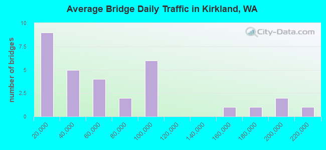
- 1,979,641Total average daily traffic
- 112,676Total average daily truck traffic
- National Bridge Inventory (NBI) Registered Bridges for Kirkland
- No street view available for this location
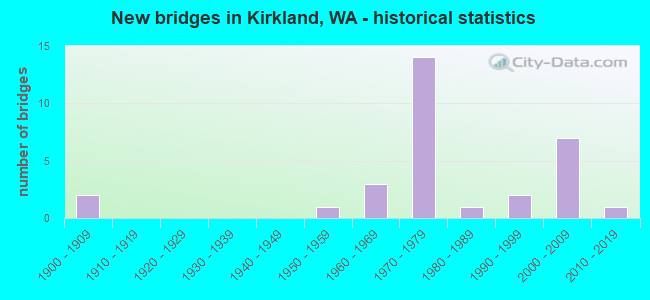
- New bridges - historical statistics
- 21900-1909
- 11950-1959
- 31960-1969
- 141970-1979
- 11980-1989
- 21990-1999
- 72000-2009
- 12010-2019
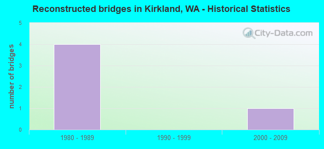
- Reconstructed bridges - Historical Statistics
- 41980-1989
- 01990-1999
- 12000-2009
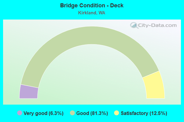
- Bridge Condition - Deck
- 6.3%Very good
- 81.3%Good
- 12.5%Satisfactory
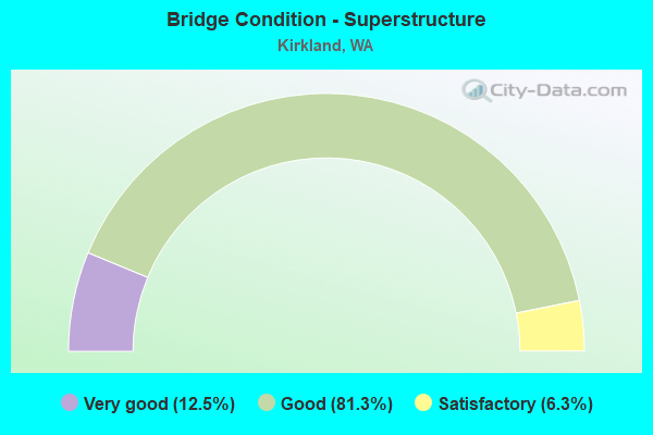
- Bridge Condition - Superstructure
- 12.5%Very good
- 81.3%Good
- 6.3%Satisfactory
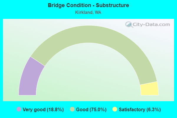
- Bridge Condition - Substructure
- 18.8%Very good
- 75.0%Good
- 6.3%Satisfactory
Find on map >> Show street view
Structure Number: 4978A, Location: 5.2 N JCT SR 520 (Lat: 47.705722, Lng: -122.180306), Route carried "on" structure: Interstate 405, Year Built: 1956, Year Reconstructed: 1994, Status: Posted for load, Structure Length: 6.07m (19.91ft), Average Daily Traffic: 91,545 (year 2019), Truck Traffic: 6%, Average Future Daily Traffic: 129,261 (year 2039), Design Load: HS 20+Mod, Features Intersected: PEDESTRIAN TRAIL
Minimum Vertical Clearance: 30+ m (98+ ft), Kilometerpoint: 32.187, Lanes on structure: 6, Base Highway Network: Yes, Owner: State Highway Agency, Approaching Roadway Width: 31.7m (104.0ft), Skew: 9 degrees, Material/Design: Concrete continuous, Design/Construction: Tee Beam, Number Of Spans In Main Unit: 3, Length of Maximum Span: 23.5m (77.1ft), Curb-To-Curb Width: 31.7m (104.0ft), Out-to-Out Width: 32.6m (107.0ft)
Condition: Deck: Good, Superstructure: Good, Substructure: Good, Operating Rating: 19.8 metric tons, Method Used To Determine Operating Rating: Load and Resistance Factor Rating (LRFR) rating reported by rating factor(RF) method using HL-93 loadings, Inventory Rating: 15.2 metric tons, Method Used To Determine Inventory Rating: Load and Resistance Factor Rating (LRFR) rating reported by rating factor(RF) method using HL-93 loadings, Structural Evaluation: High priority of corrective action, Deck Geometry: Superior to present desirable criteria, Approach Roadway Alignment: Equal to present desirable criteria, Bridge Posting: Required (Relationship of Operating Rating to Maximum Legal Load: 10.0 - 19.9% below), Length Of Structure Improvement: 6.07m (19.91ft), Designated Inspection Frequency: Every 24 months, Inspection Date: July 2021, Bridge Improvement Cost: $4,219,000, Roadway Improvement Cost: $844,000, Total Project Cost: $8,438,000 ( Estimate for 2014), Deck Structure Type: Concrete Cast-file-Place, Wearing Surface/Protective System: Wearing Surface: Bituminous, Deck Protection: Epoxy Coated Reinforcing
Find on map >> Show street view
Structure Number: 7548A, Location: 3.3 N JCT SR 520 (Lat: 47.675000, Lng: -122.188333), Route carried "on" structure: City street 625, Year Built: 1965, Status: Open, Structure Length: 4.54m (14.90ft), Average Daily Traffic: 24,500 (year 2019), Truck Traffic: 5%, Average Future Daily Traffic: 33,000 (year 2036), Design Load: HS 20, Features Intersected: NP RY, Facility Carried by Structure: CENTRAL WAY
Minimum Vertical Clearance: 30+ m (98+ ft), Kilometerpoint: 0.001, Lanes on structure: 4, Owner: City or Municipal Highway Agency, Approaching Roadway Width: 15.2m (49.9ft), Skew: 1 degrees, Material/Design: Prestressed concrete, Design/Construction: Stringer/Multi-beam, Number Of Spans In Main Unit: 3, Length of Maximum Span: 16.2m (53.1ft), Curb or Sidewalk Widths: Left: 0.6m (2.0ft), Right: 0.2m (0.7ft), Curb-To-Curb Width: 15.6m (51.2ft), Out-to-Out Width: 16.8m (55.1ft)
Condition: Deck: Good, Superstructure: Good, Substructure: Satisfactory, Operating Rating: 47.2 metric tons, Method Used To Determine Operating Rating: Load and Resistance Factor (LRFR), Inventory Rating: 32.7 metric tons, Method Used To Determine Inventory Rating: Load and Resistance Factor (LRFR), Structural Evaluation: Equal to present minimum criteria, Deck Geometry: Meets minimum limits, Underclear: Superior to present desirable criteria, Approach Roadway Alignment: Equal to present desirable criteria, Designated Inspection Frequency: Every 24 months, Inspection Date: Febuary 2021, Deck Structure Type: Concrete Cast-file-Place, Wearing Surface/Protective System: Wearing Surface: Latex Concrete
Find on map >> Show street view
Structure Number: 8615C, Location: 5.2 N JCT SR 520 (Lat: 47.706667, Lng: -122.178333), Route carried "on" structure: Interstate 405, Year Built: 1970, Year Reconstructed: 1994, Status: Open, Structure Length: 7.41m (24.31ft), Average Daily Traffic: 91,545 (year 2019), Truck Traffic: 6%, Average Future Daily Traffic: 129,261 (year 2039), Design Load: HS 20+Mod, Features Intersected: PEDESTRIAN TRAIL
Minimum Vertical Clearance: 30+ m (98+ ft), Kilometerpoint: 32.155, Lanes on structure: 6, Base Highway Network: Yes, Owner: State Highway Agency, Approaching Roadway Width: 23.8m (78.1ft), Skew: 3 degrees, Material/Design: Prestressed concrete continuous, Design/Construction: Stringer/Multi-beam, Number Of Spans In Main Unit: 3, Length of Maximum Span: 26.2m (86.0ft), Curb-To-Curb Width: 23.8m (78.1ft), Out-to-Out Width: 24.7m (81.0ft)
Condition: Deck: Good, Superstructure: Good, Substructure: Good, Operating Rating: 28.2 metric tons, Method Used To Determine Operating Rating: Load and Resistance Factor Rating (LRFR) rating reported by rating factor(RF) method using HL-93 loadings, Inventory Rating: 21.7 metric tons, Method Used To Determine Inventory Rating: Load and Resistance Factor Rating (LRFR) rating reported by rating factor(RF) method using HL-93 loadings, Structural Evaluation: Somewhat better than minimum adequacy, Deck Geometry: Meets minimum limits, Approach Roadway Alignment: Equal to present desirable criteria, Length Of Structure Improvement: 7.41m (24.31ft), Designated Inspection Frequency: Every 24 months, Inspection Date: July 2021, Bridge Improvement Cost: $3,888,000, Roadway Improvement Cost: $778,000, Total Project Cost: $7,776,000 ( Estimate for 2014), Deck Structure Type: Concrete Cast-file-Place, Wearing Surface/Protective System: Wearing Surface: Bituminous, Deck Protection: Epoxy Coated Reinforcing
Find on map >> Show street view
Structure Number: 8615D, Location: 5.5 N JCT SR 520 (Lat: 47.710472, Lng: -122.183389), Route carried "on" structure: City street , Year Built: 1969, Status: Open, Structure Length: 13.47m (44.19ft), Average Daily Traffic: 39,499 (year 2015), Truck Traffic: 5%, Average Future Daily Traffic: 59,867 (year 2036), Design Load: HS 20+Mod, Features Intersected: I-405, Facility Carried by Structure: NE 124TH ST
Minimum Vertical Clearance: 30+ m (98+ ft), Kilometerpoint: 0.290, Lanes on structure: 5, Lanes under structure: 13, Base Highway Network: Yes, Owner: State Highway Agency, Approaching Roadway Width: 21.3m (69.9ft), Material/Design: Concrete continuous, Design/Construction: Box Beam or Girders - Multiple, Number Of Spans In Main Unit: 4, Length of Maximum Span: 43.6m (143.0ft), Curb or Sidewalk Widths: Left: 1.8m (5.9ft), Right: 0.2m (0.7ft), Curb-To-Curb Width: 18.2m (59.7ft), Out-to-Out Width: 20.2m (66.3ft)
Condition: Deck: Good, Superstructure: Satisfactory, Substructure: Good, Operating Rating: 78.0 metric tons, Method Used To Determine Operating Rating: Load Factor (LF), Inventory Rating: 46.3 metric tons, Method Used To Determine Inventory Rating: Load Factor (LF), Structural Evaluation: Equal to present minimum criteria, Deck Geometry: High priority of replacement, Underclear: High priority of corrective action, Approach Roadway Alignment: Equal to present desirable criteria, Length Of Structure Improvement: 13.47m (44.19ft), Designated Inspection Frequency: Every 48 months, Inspection Date: April 2018, Bridge Improvement Cost: $6,365,000, Roadway Improvement Cost: $1,273,000, Total Project Cost: $12,730,000 ( Estimate for 2014), Deck Structure Type: Concrete Cast-file-Place, Wearing Surface/Protective System: Wearing Surface: Bituminous
Find on map >> Show street view
Structure Number: 8674A, Location: 2.6 N JCT SR 520 (Lat: 47.669444, Lng: -122.187833), Route carried "on" structure: City street , Year Built: 1970, Status: Open, Structure Length: 12.92m (42.39ft), Average Daily Traffic: 20,179 (year 2013), Truck Traffic: 5%, Average Future Daily Traffic: 30,594 (year 2035), Design Load: HS 20+Mod, Features Intersected: I-405, Facility Carried by Structure: NE 72ND PLACE
Minimum Vertical Clearance: 30+ m (98+ ft), Kilometerpoint: 0.129, Lanes on structure: 4, Lanes under structure: 13, Base Highway Network: Yes, Owner: State Highway Agency, Approaching Roadway Width: 14.6m (47.9ft), Skew: 20 degrees, Material/Design: Concrete continuous, Design/Construction: Box Beam or Girders - Multiple, Number Of Spans In Main Unit: 4, Length of Maximum Span: 33.5m (109.9ft), Curb or Sidewalk Widths: Left: 1.5m (4.9ft), Right: 1.5m (4.9ft), Curb-To-Curb Width: 14.6m (47.9ft), Out-to-Out Width: 18.4m (60.4ft)
Condition: Deck: Satisfactory, Superstructure: Good, Substructure: Good, Operating Rating: 40.8 metric tons, Method Used To Determine Operating Rating: Load and Resistance Factor Rating (LRFR) rating reported by rating factor(RF) method using HL-93 loadings, Inventory Rating: 31.4 metric tons, Method Used To Determine Inventory Rating: Load and Resistance Factor Rating (LRFR) rating reported by rating factor(RF) method using HL-93 loadings, Structural Evaluation: Better than present minimum criteria, Deck Geometry: High priority of replacement, Underclear: Meets minimum limits, Approach Roadway Alignment: Equal to present desirable criteria, Length Of Structure Improvement: 12.92m (42.39ft), Designated Inspection Frequency: Every 48 months, Inspection Date: April 2018, Bridge Improvement Cost: $4,240,000, Roadway Improvement Cost: $848,000, Total Project Cost: $8,480,000 ( Estimate for 2014), Deck Structure Type: Concrete Cast-file-Place, Wearing Surface/Protective System: Wearing Surface: Bituminous
Find on map >> Show street view
Structure Number: 8674D, Location: 3.3 N JCT SR 520 (Lat: 47.678889, Lng: -122.184167), Route carried "on" structure: Ramp Interstate 405, Year Built: 1970, Status: Open, Structure Length: 6.43m (21.10ft), Average Daily Traffic: 6,098 (year 2019), Truck Traffic: 5%, Average Future Daily Traffic: 8,610 (year 2039), Design Load: HS 20+Mod, Features Intersected: NE 85TH ST
Minimum Vertical Clearance: 30+ m (98+ ft), Kilometerpoint: 0.563, Lanes on structure: 2, Lanes under structure: 6, Owner: State Highway Agency, Approaching Roadway Width: 14.0m (45.9ft), Material/Design: Prestressed concrete continuous, Design/Construction: Stringer/Multi-beam, Number Of Spans In Main Unit: 3, Length of Maximum Span: 32.3m (106.0ft), Curb or Sidewalk Widths: Left: 0.2m (0.7ft), Right: 0.2m (0.7ft), Curb-To-Curb Width: 11.0m (36.1ft), Out-to-Out Width: 13.1m (43.0ft)
Condition: Deck: Good, Superstructure: Good, Substructure: Good, Operating Rating: 29.8 metric tons, Method Used To Determine Operating Rating: Load and Resistance Factor Rating (LRFR) rating reported by rating factor(RF) method using HL-93 loadings, Inventory Rating: 23.0 metric tons, Method Used To Determine Inventory Rating: Load and Resistance Factor Rating (LRFR) rating reported by rating factor(RF) method using HL-93 loadings, Structural Evaluation: Somewhat better than minimum adequacy, Deck Geometry: Better than present minimum criteria, Underclear: Equal to present minimum criteria, Approach Roadway Alignment: Equal to present desirable criteria, Length Of Structure Improvement: 6.43m (21.10ft), Designated Inspection Frequency: Every 48 months, Inspection Date: April 2018, Bridge Improvement Cost: $2,026,000, Roadway Improvement Cost: $405,000, Total Project Cost: $4,051,000 ( Estimate for 2014), Deck Structure Type: Concrete Cast-file-Place, Wearing Surface/Protective System: Wearing Surface: Bituminous
Find on map >> Show street view
Structure Number: 8674E, Location: 3.3 N JCT SR 520 (Lat: 47.678889, Lng: -122.184417), Route carried "on" structure: Interstate 405, Year Built: 1971, Year Reconstructed: 1994, Status: Open, Structure Length: 6.80m (22.31ft), Average Daily Traffic: 89,508 (year 2019), Truck Traffic: 6%, Average Future Daily Traffic: 126,385 (year 2039), Design Load: HS 20+Mod, Features Intersected: NE 85TH ST
Minimum Vertical Clearance: 30+ m (98+ ft), Kilometerpoint: 29.113, Lanes on structure: 5, Lanes under structure: 6, Base Highway Network: Yes, Owner: State Highway Agency, Approaching Roadway Width: 19.5m (64.0ft), Material/Design: Prestressed concrete continuous, Design/Construction: Stringer/Multi-beam, Number Of Spans In Main Unit: 3, Length of Maximum Span: 32.3m (106.0ft), Curb-To-Curb Width: 19.5m (64.0ft), Out-to-Out Width: 20.4m (66.9ft)
Condition: Deck: Good, Superstructure: Good, Substructure: Good, Operating Rating: 73.5 metric tons, Method Used To Determine Operating Rating: Load Factor (LF), Inventory Rating: 44.4 metric tons, Method Used To Determine Inventory Rating: Load Factor (LF), Structural Evaluation: Better than present minimum criteria, Deck Geometry: Meets minimum limits, Underclear: Equal to present minimum criteria, Approach Roadway Alignment: Equal to present desirable criteria, Length Of Structure Improvement: 6.80m (22.31ft), Designated Inspection Frequency: Every 48 months, Inspection Date: April 2018, Bridge Improvement Cost: $2,944,000, Roadway Improvement Cost: $589,000, Total Project Cost: $5,887,000 ( Estimate for 2014), Deck Structure Type: Concrete Cast-file-Place, Wearing Surface/Protective System: Wearing Surface: Bituminous
Find on map >> Show street view
Structure Number: 8674F, Location: 3.3 N JCT SR 520 (Lat: 47.678889, Lng: -122.184694), Route carried "on" structure: Interstate 405, Year Built: 1971, Year Reconstructed: 1994, Status: Open, Structure Length: 6.68m (21.92ft), Average Daily Traffic: 89,508 (year 2019), Truck Traffic: 6%, Average Future Daily Traffic: 126,385 (year 2039), Design Load: HS 20+Mod, Features Intersected: NE 85TH ST
Minimum Vertical Clearance: 30+ m (98+ ft), Kilometerpoint: 29.113, Lanes on structure: 5, Lanes under structure: 6, Base Highway Network: Yes, Owner: State Highway Agency, Approaching Roadway Width: 19.5m (64.0ft), Material/Design: Prestressed concrete continuous, Design/Construction: Stringer/Multi-beam, Number Of Spans In Main Unit: 3, Length of Maximum Span: 32.3m (106.0ft), Curb-To-Curb Width: 19.5m (64.0ft), Out-to-Out Width: 20.4m (66.9ft)
Condition: Deck: Good, Superstructure: Good, Substructure: Good, Operating Rating: 70.7 metric tons, Method Used To Determine Operating Rating: Load Factor (LF), Inventory Rating: 42.6 metric tons, Method Used To Determine Inventory Rating: Load Factor (LF), Structural Evaluation: Better than present minimum criteria, Deck Geometry: Meets minimum limits, Underclear: Equal to present minimum criteria, Approach Roadway Alignment: Equal to present desirable criteria, Length Of Structure Improvement: 6.68m (21.92ft), Designated Inspection Frequency: Every 48 months, Inspection Date: April 2018, Bridge Improvement Cost: $2,891,000, Roadway Improvement Cost: $578,000, Total Project Cost: $5,782,000 ( Estimate for 2014), Deck Structure Type: Concrete Cast-file-Place, Wearing Surface/Protective System: Wearing Surface: Bituminous
Find on map >> Show street view
Structure Number: 8674G, Location: 3.3 N JCT SR 520 (Lat: 47.678861, Lng: -122.184944), Route carried "on" structure: Ramp Interstate 405, Year Built: 1971, Status: Open, Structure Length: 6.80m (22.31ft), Average Daily Traffic: 7,592 (year 2019), Truck Traffic: 5%, Average Future Daily Traffic: 10,719 (year 2039), Design Load: HS 20+Mod, Features Intersected: NE 85TH ST
Minimum Vertical Clearance: 30+ m (98+ ft), Kilometerpoint: 0.756, Lanes on structure: 2, Lanes under structure: 6, Owner: State Highway Agency, Approaching Roadway Width: 11.3m (37.1ft), Material/Design: Prestressed concrete continuous, Design/Construction: Stringer/Multi-beam, Number Of Spans In Main Unit: 3, Length of Maximum Span: 32.3m (106.0ft), Curb or Sidewalk Widths: Left: 0.2m (0.7ft), Right: 0.2m (0.7ft), Curb-To-Curb Width: 11.0m (36.1ft), Out-to-Out Width: 11.9m (39.0ft)
Condition: Deck: Good, Superstructure: Good, Substructure: Good, Operating Rating: 25.3 metric tons, Method Used To Determine Operating Rating: Load and Resistance Factor Rating (LRFR) rating reported by rating factor(RF) method using HL-93 loadings, Inventory Rating: 19.4 metric tons, Method Used To Determine Inventory Rating: Load and Resistance Factor Rating (LRFR) rating reported by rating factor(RF) method using HL-93 loadings, Structural Evaluation: Meets minimum limits, Deck Geometry: Better than present minimum criteria, Underclear: Equal to present minimum criteria, Approach Roadway Alignment: Equal to present desirable criteria, Length Of Structure Improvement: 6.80m (22.31ft), Designated Inspection Frequency: Every 48 months, Inspection Date: April 2018, Bridge Improvement Cost: $1,740,000, Roadway Improvement Cost: $348,000, Total Project Cost: $3,479,000 ( Estimate for 2014), Deck Structure Type: Concrete Cast-file-Place, Wearing Surface/Protective System: Wearing Surface: Bituminous
Find on map >> Show street view
Structure Number: 13716A, Location: 5.5 N JCT SR 520 (Lat: 47.709417, Lng: -122.180167), Route carried "on" structure: City street , Year Built: 1990, Year Reconstructed: 2005, Status: Open, Structure Length: 1.10m (3.61ft), Average Daily Traffic: 35,856 (year 2013), Truck Traffic: 5%, Average Future Daily Traffic: 55,018 (year 2033), Design Load: HS 20, Features Intersected: RAMP/120TH AVE, Facility Carried by Structure: NE 124TH ST
Minimum Vertical Clearance: 30+ m (98+ ft), Kilometerpoint: 0.563, Lanes on structure: 6, Lanes under structure: 1, Base Highway Network: Yes, Owner: State Highway Agency, Approaching Roadway Width: 34.1m (111.9ft), Material/Design: Concrete, Design/Construction: Slab, Number Of Spans In Main Unit: 1, Length of Maximum Span: 9.4m (30.8ft), Curb-To-Curb Width: 34.1m (111.9ft), Out-to-Out Width: 35.1m (115.2ft)
Condition: Deck: Good, Superstructure: Good, Substructure: Good, Operating Rating: 60.8 metric tons, Method Used To Determine Operating Rating: Load Factor (LF), Inventory Rating: 36.3 metric tons, Method Used To Determine Inventory Rating: Load Factor (LF), Structural Evaluation: Better than present minimum criteria, Deck Geometry: Superior to present desirable criteria, Underclear: Somewhat better than minimum adequacy, Approach Roadway Alignment: Equal to present desirable criteria, Length Of Structure Improvement: 1.10m (3.61ft), Designated Inspection Frequency: Every 48 months, Inspection Date: September 2019, Bridge Improvement Cost: $821,000, Roadway Improvement Cost: $164,000, Total Project Cost: $1,642,000 ( Estimate for 2014), Deck Structure Type: Concrete Cast-file-Place, Wearing Surface/Protective System: Wearing Surface: Monolithic Concrete, Deck Protection: Epoxy Coated Reinforcing
Find on map >> Show street view
Structure Number: 16932A, Location: 5.7 N JCT SR 520 (Lat: 47.714833, Lng: -122.185917), Route carried "on" structure: City street , Year Built: 2006, Status: Open, Structure Length: 3.78m (12.40ft), Average Daily Traffic: 1,200 (year 2003), Truck Traffic: 5%, Design Load: HL 93, Features Intersected: SB I-405, Facility Carried by Structure: NE 128TH ST
Minimum Vertical Clearance: 30+ m (98+ ft), Kilometerpoint: 0.097, Lanes on structure: 6, Lanes under structure: 5, Owner: State Highway Agency, Approaching Roadway Width: 24.7m (81.0ft), Skew: 2 degrees, Material/Design: Steel, Design/Construction: Stringer/Multi-beam, Number Of Spans In Main Unit: 1, Length of Maximum Span: 37.8m (124.0ft), Curb or Sidewalk Widths: Left: 5.7m (18.7ft), Right: 3.0m (9.8ft), Curb-To-Curb Width: 24.6m (80.7ft), Out-to-Out Width: 34.1m (111.9ft)
Condition: Deck: Good, Superstructure: Good, Substructure: Good, Operating Rating: 69.8 metric tons, Method Used To Determine Operating Rating: Load Factor (LF), Inventory Rating: 41.7 metric tons, Method Used To Determine Inventory Rating: Load Factor (LF), Structural Evaluation: Better than present minimum criteria, Deck Geometry: Somewhat better than minimum adequacy, Underclear: High priority of corrective action, Approach Roadway Alignment: Equal to present desirable criteria, Length Of Structure Improvement: 3.78m (12.40ft), Designated Inspection Frequency: Every 24 months, Inspection Date: Febuary 2020, Bridge Improvement Cost: $2,058,000, Roadway Improvement Cost: $412,000, Total Project Cost: $4,117,000 ( Estimate for 2014), Deck Structure Type: Concrete Cast-file-Place, Wearing Surface/Protective System: Wearing Surface: Monolithic Concrete
Find on map >> Show street view
Structure Number: 16932B, Location: 5.7 N JCT SR 520 (Lat: 47.714833, Lng: -122.185247), Route carried "on" structure: City street , Year Built: 2006, Status: Open, Structure Length: 3.90m (12.80ft), Average Daily Traffic: 7,766 (year 2007), Truck Traffic: 5%, Design Load: HL 93, Features Intersected: NB I-405, Facility Carried by Structure: NE 128TH ST
Minimum Vertical Clearance: 30+ m (98+ ft), Kilometerpoint: 0.161, Lanes on structure: 6, Lanes under structure: 5, Owner: State Highway Agency, Approaching Roadway Width: 26.8m (87.9ft), Skew: 2 degrees, Material/Design: Steel, Design/Construction: Stringer/Multi-beam, Number Of Spans In Main Unit: 1, Length of Maximum Span: 39.0m (128.0ft), Curb or Sidewalk Widths: Left: 5.7m (18.7ft), Right: 3.0m (9.8ft), Curb-To-Curb Width: 26.8m (87.9ft), Out-to-Out Width: 36.0m (118.1ft)
Condition: Deck: Satisfactory, Superstructure: Very good, Substructure: Very good, Operating Rating: 64.4 metric tons, Method Used To Determine Operating Rating: Load Factor (LF), Inventory Rating: 38.1 metric tons, Method Used To Determine Inventory Rating: Load Factor (LF), Structural Evaluation: Equal to present desirable criteria, Deck Geometry: Better than present minimum criteria, Underclear: High priority of corrective action, Approach Roadway Alignment: Equal to present desirable criteria, Length Of Structure Improvement: 3.90m (12.80ft), Designated Inspection Frequency: Every 24 months, Inspection Date: Febuary 2020, Bridge Improvement Cost: $2,304,000, Roadway Improvement Cost: $461,000, Total Project Cost: $4,608,000 ( Estimate for 2014), Deck Structure Type: Concrete Cast-file-Place, Wearing Surface/Protective System: Wearing Surface: Bituminous
Find on map >> Show street view
Structure Number: 17042A, Location: 5.0 N JCT SR 520 (Lat: 47.703803, Lng: -122.179286), Route carried "on" structure: Interstate 405, Year Built: 2007, Status: Open, Structure Length: 4.02m (13.19ft), Average Daily Traffic: 91,545 (year 2019), Truck Traffic: 6%, Average Future Daily Traffic: 129,261 (year 2039), Design Load: HL 93, Features Intersected: NE 116TH ST
Minimum Vertical Clearance: 30+ m (98+ ft), Kilometerpoint: 31.913, Lanes on structure: 5, Lanes under structure: 5, Base Highway Network: Yes, Owner: State Highway Agency, Approaching Roadway Width: 24.4m (80.1ft), Material/Design: Prestressed concrete, Design/Construction: Stringer/Multi-beam, Number Of Spans In Main Unit: 1, Length of Maximum Span: 39.3m (128.9ft), Curb-To-Curb Width: 24.4m (80.1ft), Out-to-Out Width: 25.1m (82.3ft)
Condition: Deck: Good, Superstructure: Good, Substructure: Very good, Operating Rating: 81.6 metric tons, Method Used To Determine Operating Rating: Load Factor (LF), Inventory Rating: 49.0 metric tons, Method Used To Determine Inventory Rating: Load Factor (LF), Structural Evaluation: Better than present minimum criteria, Deck Geometry: Equal to present minimum criteria, Underclear: Meets minimum limits, Approach Roadway Alignment: Equal to present desirable criteria, Length Of Structure Improvement: 4.02m (13.19ft), Designated Inspection Frequency: Every 24 months, Inspection Date: July 2021, Bridge Improvement Cost: $2,165,000, Roadway Improvement Cost: $433,000, Total Project Cost: $4,330,000 ( Estimate for 2014), Deck Structure Type: Concrete Cast-file-Place, Wearing Surface/Protective System: Wearing Surface: Monolithic Concrete, Deck Protection: Epoxy Coated Reinforcing
Find on map >> Show street view
Structure Number: 17042B, Location: 5.0 N JCT SR 520 (Lat: 47.703806, Lng: -122.179758), Route carried "on" structure: Interstate 405, Year Built: 2006, Status: Open, Structure Length: 4.02m (13.19ft), Average Daily Traffic: 91,545 (year 2019), Truck Traffic: 6%, Average Future Daily Traffic: 129,261 (year 2039), Design Load: HL 93, Features Intersected: NE 116TH ST
Minimum Vertical Clearance: 30+ m (98+ ft), Kilometerpoint: 31.913, Lanes on structure: 5, Lanes under structure: 5, Base Highway Network: Yes, Owner: State Highway Agency, Approaching Roadway Width: 29.3m (96.1ft), Material/Design: Prestressed concrete, Design/Construction: Stringer/Multi-beam, Number Of Spans In Main Unit: 1, Length of Maximum Span: 39.3m (128.9ft), Curb-To-Curb Width: 29.3m (96.1ft), Out-to-Out Width: 30.1m (98.8ft)
Condition: Deck: Good, Superstructure: Good, Substructure: Good, Operating Rating: 81.6 metric tons, Method Used To Determine Operating Rating: Load Factor (LF), Inventory Rating: 49.0 metric tons, Method Used To Determine Inventory Rating: Load Factor (LF), Structural Evaluation: Better than present minimum criteria, Deck Geometry: Superior to present desirable criteria, Underclear: Equal to present desirable criteria, Approach Roadway Alignment: Equal to present desirable criteria, Length Of Structure Improvement: 4.02m (13.19ft), Designated Inspection Frequency: Every 24 months, Inspection Date: July 2021, Bridge Improvement Cost: $2,587,000, Roadway Improvement Cost: $517,000, Total Project Cost: $5,174,000 ( Estimate for 2014), Deck Structure Type: Concrete Cast-file-Place, Wearing Surface/Protective System: Wearing Surface: Monolithic Concrete, Deck Protection: Epoxy Coated Reinforcing
Find on map >> Show street view
Structure Number: 18053A, Location: 0.1 W I-405 (Lat: 47.704083, Lng: -122.181944), Route carried "on" structure: City street 625, Year Built: 2012, Status: Open, Structure Length: 3.93m (12.89ft), Average Daily Traffic: 18,100 (year 2019), Truck Traffic: 8%, Average Future Daily Traffic: 25,000 (year 2037), Design Load: HL 93, Features Intersected: RAILROAD, Facility Carried by Structure: NE 116TH ST
Minimum Vertical Clearance: 30+ m (98+ ft), Kilometerpoint: 2.092, Lanes on structure: 6, Owner: City or Municipal Highway Agency, Maintenance Responsibility: State Highway Agency, Approaching Roadway Width: 23.2m (76.1ft), Skew: 1 degrees, Material/Design: Prestressed concrete continuous, Design/Construction: Slab, Number Of Spans In Main Unit: 3, Length of Maximum Span: 17.7m (58.1ft), Curb or Sidewalk Widths: Left: 1.9m (6.2ft), Right: 2.0m (6.6ft), Curb-To-Curb Width: 23.2m (76.1ft), Out-to-Out Width: 27.7m (90.9ft)
Condition: Deck: Very good, Superstructure: Very good, Substructure: Very good, Operating Rating: 45.4 metric tons, Method Used To Determine Operating Rating: Load and Resistance Factor Rating (LRFR) rating reported by rating factor(RF) method using HL-93 loadings, Inventory Rating: 35.0 metric tons, Method Used To Determine Inventory Rating: Load and Resistance Factor Rating (LRFR) rating reported by rating factor(RF) method using HL-93 loadings, Structural Evaluation: Equal to present desirable criteria, Deck Geometry: Meets minimum limits, Approach Roadway Alignment: Equal to present desirable criteria, Length Of Structure Improvement: 3.93m (12.89ft), Designated Inspection Frequency: Every 24 months, Inspection Date: Febuary 2021, Bridge Improvement Cost: $2,012,000, Roadway Improvement Cost: $402,000, Total Project Cost: $4,025,000 ( Estimate for 2014), Deck Structure Type: Concrete Cast-file-Place, Wearing Surface/Protective System: Wearing Surface: Monolithic Concrete, Deck Protection: Epoxy Coated Reinforcing
Find on map >> Show street view
Structure Number: 85561, Location: 1.5 MI N CENTRAL W (Lat: 47.698333, Lng: -122.206667), Route carried "on" structure: City street 625, Year Built: 1974, Status: Open, Structure Length: 7.47m (24.51ft), Average Daily Traffic: 20,400 (year 2017), Truck Traffic: 8%, Average Future Daily Traffic: 28,000 (year 2036), Design Load: HS 20, Features Intersected: FORBES CREEK, Facility Carried by Structure: 98 AVE NE
Minimum Vertical Clearance: 30+ m (98+ ft), Kilometerpoint: 0.001, Lanes on structure: 3, Owner: City or Municipal Highway Agency, Approaching Roadway Width: 15.8m (51.8ft), Material/Design: Concrete continuous, Design/Construction: Slab, Number Of Spans In Main Unit: 4, Length of Maximum Span: 21.3m (69.9ft), Curb or Sidewalk Widths: Left: 1.4m (4.6ft), Right: 1.4m (4.6ft), Curb-To-Curb Width: 15.8m (51.8ft), Out-to-Out Width: 19.6m (64.3ft)
Condition: Deck: Good, Superstructure: Good, Substructure: Good, Channel: Very good, Operating Rating: 44.4 metric tons, Method Used To Determine Operating Rating: Load and Resistance Factor (LRFR), Inventory Rating: 32.7 metric tons, Method Used To Determine Inventory Rating: Load and Resistance Factor (LRFR), Structural Evaluation: Better than present minimum criteria, Deck Geometry: Better than present minimum criteria, Waterway Adequacy: Equal to present desirable criteria, Approach Roadway Alignment: Equal to present desirable criteria, Designated Inspection Frequency: Every 24 months, Inspection Date: Febuary 2021, Deck Structure Type: Concrete Cast-file-Place, Wearing Surface/Protective System: Wearing Surface: Bituminous
Find on map >> Show street view
Structure Number: 8615D, Location: 5.5 N JCT SR 520 (Lat: 47.710472, Lng: -122.183389), Route carried "under" structure: Interstate 405, Year Built: 1969, Structure Length: 0. m, Average Daily Traffic: 144,425 (year 2019), Truck Traffic: 6%, Features Intersected: I-405, Facility Carried by Structure: NE 124TH ST
Minimum Vertical Clearance: 5.59m (18.34ft), Kilometerpoint: 32.686, Lanes on structure: 5, Lanes under structure: 13, Material/Design: Concrete continuous, Design/Construction: Box Beam or Girders - Multiple, Length of Maximum Span: 43.6m (143.0ft)
Find on map >> Show street view
Structure Number: 8674A, Location: 2.6 N JCT SR 520 (Lat: 47.669444, Lng: -122.187833), Route carried "under" structure: Interstate 405, Year Built: 1970, Structure Length: 0. m, Average Daily Traffic: 186,398 (year 2019), Truck Traffic: 6%, Features Intersected: I-405, Facility Carried by Structure: NE 72ND PLACE
Minimum Vertical Clearance: 6.17m (20.24ft), Kilometerpoint: 28.067, Lanes on structure: 4, Lanes under structure: 11, Material/Design: Concrete continuous, Design/Construction: Box Beam or Girders - Multiple, Length of Maximum Span: 33.5m (109.9ft)
Find on map >> Show street view
Structure Number: 8674C, Location: 3.0 N JCT SR 520 (Lat: 47.675236, Lng: -122.184997), Route carried "under" structure: Interstate 405, Year Built: 1970, Structure Length: 0. m, Average Daily Traffic: 179,015 (year 2019), Truck Traffic: 6%, Features Intersected: I-405, Facility Carried by Structure: NE 80TH ST PED
Minimum Vertical Clearance: 5.49m (18.01ft), Kilometerpoint: 28.711, Lanes under structure: 10, Material/Design: Steel, Design/Construction: Arch - Thru, Length of Maximum Span: 99.1m (325.1ft)
Find on map >> Show street view
Structure Number: 8674D, Location: JCT I-405 (Lat: 47.678889, Lng: -122.184167), Route carried "under" structure: City street 405, Year Built: 1970, Structure Length: 0. m, Average Daily Traffic: 44,198 (year 2012), Truck Traffic: 3%, Features Intersected: NE 85TH ST
Minimum Vertical Clearance: 5.54m (18.18ft), Kilometerpoint: 0.225, Lanes on structure: 2, Lanes under structure: 6, Material/Design: Prestressed concrete continuous, Design/Construction: Stringer/Multi-beam, Length of Maximum Span: 32.3m (106.0ft)
Find on map >> Show street view
Structure Number: 8674E, Location: JCT I-405 (Lat: 47.678889, Lng: -122.184417), Route carried "under" structure: City street 405, Year Built: 1971, Structure Length: 0. m, Average Daily Traffic: 44,198 (year 2012), Truck Traffic: 3%, Features Intersected: NE 85TH ST
Minimum Vertical Clearance: 5.94m (19.49ft), Kilometerpoint: 0.225, Lanes on structure: 5, Lanes under structure: 6, Material/Design: Prestressed concrete continuous, Design/Construction: Stringer/Multi-beam, Length of Maximum Span: 32.3m (106.0ft)
Find on map >> Show street view
Structure Number: 8674F, Location: JCT I-405 (Lat: 47.678889, Lng: -122.184694), Route carried "under" structure: City street 405, Year Built: 1971, Structure Length: 0. m, Average Daily Traffic: 44,198 (year 2012), Truck Traffic: 3%, Features Intersected: NE 85TH ST
Minimum Vertical Clearance: 5.46m (17.91ft), Kilometerpoint: 0.193, Lanes on structure: 5, Lanes under structure: 6, Material/Design: Prestressed concrete continuous, Design/Construction: Stringer/Multi-beam, Length of Maximum Span: 32.3m (106.0ft)
Find on map >> Show street view
Structure Number: 8674G, Location: JCT I-405 (Lat: 47.678861, Lng: -122.184944), Route carried "under" structure: City street 405, Year Built: 1971, Structure Length: 0. m, Average Daily Traffic: 44,198 (year 2012), Truck Traffic: 3%, Features Intersected: NE 85TH ST
Minimum Vertical Clearance: 6.73m (22.08ft), Kilometerpoint: 0.161, Lanes on structure: 2, Lanes under structure: 6, Material/Design: Prestressed concrete continuous, Design/Construction: Stringer/Multi-beam, Length of Maximum Span: 32.3m (106.0ft)
Find on map >> Show street view
Structure Number: 10918A, Location: 2.0 N JCT SR 520 (Lat: 47.661131, Lng: -122.187039), Route carried "under" structure: Interstate 405, Year Built: 1978, Structure Length: 0. m, Average Daily Traffic: 199,131 (year 2019), Truck Traffic: 6%, Features Intersected: I-405, Facility Carried by Structure: PEDESTRIAN TRAFFIC
Minimum Vertical Clearance: 5.74m (18.83ft), Kilometerpoint: 27.117, Lanes under structure: 10, Material/Design: Concrete continuous, Design/Construction: Tee Beam, Length of Maximum Span: 27.4m (89.9ft)
Find on map >> Show street view
Structure Number: 11604A, Location: 2.6 N JCT SR 520 (Lat: 47.668722, Lng: -122.187722), Route carried "under" structure: Ramp Interstate 405, Year Built: 1980, Structure Length: 0. m, Average Daily Traffic: 6,124 (year 2012), Truck Traffic: 5%, Features Intersected: SB 405 OFF RAMP TO 72ND, Facility Carried by Structure: FLYER STOP PED TRF
Minimum Vertical Clearance: 5.77m (18.93ft), Kilometerpoint: 0.338, Lanes under structure: 2, Material/Design: Concrete continuous, Design/Construction: Tee Beam, Length of Maximum Span: 28.7m (94.2ft)
Find on map >> Show street view
Structure Number: 13716A, Location: 5.5 N JCT SR 520 (Lat: 47.709417, Lng: -122.180167), Route carried "under" structure: Ramp Interstate 405, Year Built: 1990, Structure Length: 0. m, Average Daily Traffic: 6,271 (year 2008), Truck Traffic: 5%, Features Intersected: RAMP/120TH AVE, Facility Carried by Structure: NE 124TH ST
Minimum Vertical Clearance: 5.18m (16.99ft), Kilometerpoint: 0.241, Lanes on structure: 6, Lanes under structure: 1, Material/Design: Concrete, Design/Construction: Slab, Length of Maximum Span: 9.4m (30.8ft)
Find on map >> Show street view
Structure Number: 16221A, Location: 4.0 N JCT SR 520 (Lat: 47.689583, Lng: -122.181722), Route carried "under" structure: Interstate 405, Year Built: 2002, Structure Length: 0. m, Average Daily Traffic: 210,671 (year 2019), Truck Traffic: 6%, Features Intersected: I-405, Facility Carried by Structure: PED/EMRGNCY ACCESS
Minimum Vertical Clearance: 5.79m (19.00ft), Kilometerpoint: 30.320, Lanes under structure: 8, Material/Design: Prestressed concrete continuous, Design/Construction: Stringer/Multi-beam, Length of Maximum Span: 29.6m (97.1ft)
Find on map >> Show street view
Structure Number: 16932A, Location: 5.7 N JCT SR 520 (Lat: 47.714833, Lng: -122.185917), Route carried "under" structure: Interstate 405, Year Built: 2006, Structure Length: 0. m, Average Daily Traffic: 72,213 (year 2019), Truck Traffic: 6%, Features Intersected: SB I-405, Facility Carried by Structure: NE 128TH ST
Minimum Vertical Clearance: 5.49m (18.01ft), Kilometerpoint: 33.233, Lanes on structure: 6, Lanes under structure: 5, Material/Design: Steel, Design/Construction: Stringer/Multi-beam, Length of Maximum Span: 37.8m (124.0ft)
Find on map >> Show street view
Structure Number: 16932B, Location: 5.7 N JCT SR 520 (Lat: 47.714833, Lng: -122.185247), Route carried "under" structure: Interstate 405, Year Built: 2006, Structure Length: 0. m, Average Daily Traffic: 72,213 (year 2019), Truck Traffic: 6%, Features Intersected: NB I-405, Facility Carried by Structure: NE 128TH ST
Minimum Vertical Clearance: 5.72m (18.77ft), Kilometerpoint: 33.233, Lanes on structure: 6, Lanes under structure: 5, Material/Design: Steel, Design/Construction: Stringer/Multi-beam, Length of Maximum Span: 39.0m (128.0ft)
Find on map >> Show street view
Structure Number: 89062, Location: .42 W I405 & 85th (Lat: 47.676081, Lng: -122.191372), Route carried "under" structure: City street 2226, Year Built: 1900, Structure Length: 0. m, Average Daily Traffic: 1 (year 2019), Features Intersected: Kirkland Way, Facility Carried by Structure: Cross Kirkland Cor
Minimum Vertical Clearance: 3.51m (11.52ft), Kilometerpoint: 0.001, Lanes under structure: 2, Material/Design: Steel, Design/Construction: Stringer/Multi-beam, Length of Maximum Span: 12.2m (40.0ft)
Find on map >> Show street view
Structure Number: 89063, Location: .16 W 108th Ave N.E. (Lat: 47.666667, Lng: -122.199633), Route carried "under" structure: City street 2072, Year Built: 1900, Structure Length: 0. m, Average Daily Traffic: 1 (year 2019), Features Intersected: NE 68th Street, Facility Carried by Structure: Coss Kirkland Cor
Minimum Vertical Clearance: 4.57m (14.99ft), Kilometerpoint: 0.001, Lanes under structure: 2, Material/Design: Steel, Design/Construction: Stringer/Multi-beam, Length of Maximum Span: 16.8m (55.1ft)