Bridge Statistics for King City, California (CA)
Condition, Traffic, Stress, Structural Evaluation, Project Costs
- National Bridge Inventory (NBI) Statistics
- 15Number of bridges
- 518ft / 158mTotal length
- 142,508Total average daily traffic
- 11,345Total average daily truck traffic
- National Bridge Inventory (NBI) Registered Bridges for King City
- No street view available for this location
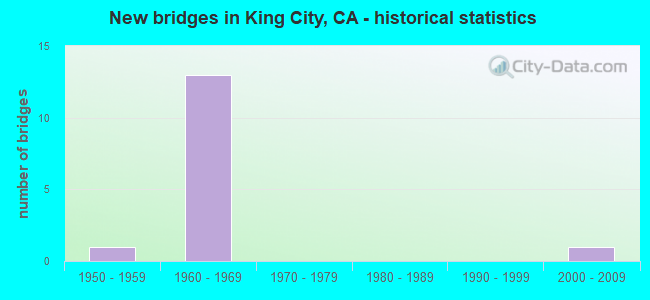
- New bridges - historical statistics
- 11950-1959
- 131960-1969
- 12000-2009


- Bridge Condition - Deck
- 70.0%Good
- 30.0%Fair

- Bridge Condition - Superstructure
- 90.0%Good
- 10.0%Fair

- Bridge Condition - Substructure
- 80.0%Good
- 10.0%Satisfactory
- 10.0%Fair

- Bridge Condition - Channel
- 20.0%Excellent
- 80.0%Satisfactory
Find on map >> Show street view
Structure Number: 44 0032L, Location: 05-MON-101-R41.36L (Lat: 36.203603, Lng: -121.139200), Route carried "on" structure: US 101, Year Built: 1968, Status: Open, Structure Length: 60.24m (197.64ft), Average Daily Traffic: 11,750 (year 2010), Truck Traffic: 19%, Average Future Daily Traffic: 23,378 (year 2041), Design Load: HS 20+Mod, Features Intersected: SALINAS RIVER
Minimum Vertical Clearance: 30+ m (98+ ft), Kilometerpoint: 41.360, Lanes on structure: 2, Base Highway Network: Yes (Inventory Route: 1, Subroute: 1), Owner: State Highway Agency, Approaching Roadway Width: 11.3m (37.1ft), Skew: 9 degrees, Material/Design: Concrete continuous, Design/Construction: Box Beam or Girders - Multiple, Number Of Spans In Main Unit: 19, Length of Maximum Span: 33.7m (110.6ft), Curb-To-Curb Width: 11.3m (37.1ft), Out-to-Out Width: 11.9m (39.0ft)
Condition: Deck: Fair, Superstructure: Good, Substructure: Good, Channel: Satisfactory, Operating Rating: 35.0 metric tons, Method Used To Determine Operating Rating: Load and Resistance Factor Rating (LRFR) rating reported by rating factor(RF) method using HL-93 loadings, Inventory Rating: 26.9 metric tons, Method Used To Determine Inventory Rating: Load and Resistance Factor Rating (LRFR) rating reported by rating factor(RF) method using HL-93 loadings, Structural Evaluation: Equal to present minimum criteria, Deck Geometry: Equal to present minimum criteria, Waterway Adequacy: Superior to present desirable criteria, Approach Roadway Alignment: Equal to present desirable criteria, Designated Inspection Frequency: Every 24 months, Inspection Date: October 2021, Deck Structure Type: Concrete Cast-file-Place
Find on map >> Show street view
Structure Number: 44 0032R, Location: 05-MON-101-R41.36R (Lat: 36.203792, Lng: -121.140797), Route carried "on" structure: US 101, Year Built: 1956, Year Reconstructed: 1968, Status: Open, Structure Length: 55.04m (180.58ft), Average Daily Traffic: 15,900 (year 2009), Truck Traffic: 13%, Average Future Daily Traffic: 25,980 (year 2041), Design Load: HS 20+Mod, Features Intersected: SALINAS RIVER
Minimum Vertical Clearance: 30+ m (98+ ft), Kilometerpoint: 41.360, Lanes on structure: 2, Base Highway Network: Yes (Inventory Route: 1, Subroute: 1), Owner: State Highway Agency, Approaching Roadway Width: 8.5m (27.9ft), Skew: 2 degrees, Material/Design: Steel, Design/Construction: Stringer/Multi-beam, Number Of Spans In Main Unit: 17, Length of Maximum Span: 39.5m (129.6ft), Curb or Sidewalk Widths: Left: 0.6m (2.0ft), Right: 0.6m (2.0ft), Curb-To-Curb Width: 8.5m (27.9ft), Out-to-Out Width: 10.2m (33.5ft)
Condition: Deck: Fair, Superstructure: Good, Substructure: Good, Channel: Satisfactory, Operating Rating: 78.4 metric tons, Method Used To Determine Operating Rating: Load Factor (LF), Inventory Rating: 47.0 metric tons, Method Used To Determine Inventory Rating: Load Factor (LF), Structural Evaluation: Better than present minimum criteria, Deck Geometry: High priority of corrective action, Waterway Adequacy: Superior to present desirable criteria, Approach Roadway Alignment: Equal to present desirable criteria, Designated Inspection Frequency: Every 24 months, Inspection Date: October 2021, Deck Structure Type: Concrete Cast-file-Place
Find on map >> Show street view
Structure Number: 44 0127L, Location: 05-MON-101-R41.19L (Lat: 36.204097, Lng: -121.137381), Route carried "on" structure: US 101, Year Built: 1968, Status: Open, Structure Length: 3.44m (11.29ft), Average Daily Traffic: 17,600 (year 2010), Truck Traffic: 20%, Average Future Daily Traffic: 35,817 (year 2041), Design Load: HS 20+Mod, Features Intersected: BROADWAY
Minimum Vertical Clearance: 30+ m (98+ ft), Kilometerpoint: 41.190, Lanes on structure: 3, Lanes under structure: 2, Base Highway Network: Yes (Inventory Route: 1, Subroute: 1), Owner: State Highway Agency, Approaching Roadway Width: 21.0m (68.9ft), Material/Design: Concrete continuous, Design/Construction: Box Beam or Girders - Multiple, Number Of Spans In Main Unit: 3, Length of Maximum Span: 16.8m (55.1ft), Curb-To-Curb Width: 21.0m (68.9ft), Out-to-Out Width: 21.6m (70.9ft)
Condition: Deck: Good, Superstructure: Good, Substructure: Good, Operating Rating: 30.1 metric tons, Method Used To Determine Operating Rating: Load and Resistance Factor Rating (LRFR) rating reported by rating factor(RF) method using HL-93 loadings, Inventory Rating: 23.3 metric tons, Method Used To Determine Inventory Rating: Load and Resistance Factor Rating (LRFR) rating reported by rating factor(RF) method using HL-93 loadings, Structural Evaluation: Somewhat better than minimum adequacy, Deck Geometry: Superior to present desirable criteria, Underclear: High priority of corrective action, Approach Roadway Alignment: Equal to present desirable criteria, Designated Inspection Frequency: Every 24 months, Inspection Date: October 2021, Deck Structure Type: Concrete Cast-file-Place
Find on map >> Show street view
Structure Number: 44 0127R, Location: 05-MON-101-R41.19R (Lat: 36.204564, Lng: -121.137539), Route carried "on" structure: US 101, Year Built: 1968, Status: Open, Structure Length: 3.54m (11.61ft), Average Daily Traffic: 15,900 (year 2009), Average Future Daily Traffic: 25,980 (year 2041), Design Load: HS 20+Mod, Features Intersected: BROADWAY
Minimum Vertical Clearance: 30+ m (98+ ft), Kilometerpoint: 41.190, Lanes on structure: 2, Lanes under structure: 2, Base Highway Network: Yes (Inventory Route: 1, Subroute: 1), Owner: State Highway Agency, Approaching Roadway Width: 11.3m (37.1ft), Skew: 1 degrees, Material/Design: Concrete continuous, Design/Construction: Box Beam or Girders - Multiple, Number Of Spans In Main Unit: 3, Length of Maximum Span: 17.1m (56.1ft), Curb-To-Curb Width: 11.3m (37.1ft), Out-to-Out Width: 11.9m (39.0ft)
Condition: Deck: Good, Superstructure: Good, Substructure: Good, Operating Rating: 47.0 metric tons, Method Used To Determine Operating Rating: Load and Resistance Factor Rating (LRFR) rating reported by rating factor(RF) method using HL-93 loadings, Inventory Rating: 33.7 metric tons, Method Used To Determine Inventory Rating: Load and Resistance Factor Rating (LRFR) rating reported by rating factor(RF) method using HL-93 loadings, Structural Evaluation: Better than present minimum criteria, Deck Geometry: Somewhat better than minimum adequacy, Underclear: High priority of corrective action, Approach Roadway Alignment: Equal to present desirable criteria, Designated Inspection Frequency: Every 24 months, Inspection Date: October 2021, Deck Structure Type: Concrete Cast-file-Place, Wearing Surface/Protective System: Wearing Surface: Bituminous
Find on map >> Show street view
Structure Number: 44 0178, Location: 05-MON-101-R39.77 (Lat: 36.201056, Lng: -121.112408), Route carried "on" structure: City street , Year Built: 1968, Status: Open, Structure Length: 5.86m (19.23ft), Average Daily Traffic: 5,500 (year 2010), Truck Traffic: 5%, Average Future Daily Traffic: 9,116 (year 2041), Design Load: HS 20+Mod, Features Intersected: US HIGHWAY 101, Facility Carried by Structure: 1ST ST (CO RD G15)
Minimum Vertical Clearance: 30+ m (98+ ft), Kilometerpoint: 0.000, Lanes on structure: 2, Lanes under structure: 4, Owner: State Highway Agency, Approaching Roadway Width: 12.2m (40.0ft), Skew: 3 degrees, Material/Design: Concrete continuous, Design/Construction: Box Beam or Girders - Multiple, Number Of Spans In Main Unit: 2, Length of Maximum Span: 29.3m (96.1ft), Curb or Sidewalk Widths: Left: 1.5m (4.9ft), Right: 0.0m, Curb-To-Curb Width: 12.2m (40.0ft), Out-to-Out Width: 14.3m (46.9ft)
Condition: Deck: Good, Superstructure: Good, Substructure: Satisfactory, Operating Rating: 47.6 metric tons, Method Used To Determine Operating Rating: Load and Resistance Factor Rating (LRFR) rating reported by rating factor(RF) method using HL-93 loadings, Inventory Rating: 34.0 metric tons, Method Used To Determine Inventory Rating: Load and Resistance Factor Rating (LRFR) rating reported by rating factor(RF) method using HL-93 loadings, Structural Evaluation: Equal to present minimum criteria, Deck Geometry: Somewhat better than minimum adequacy, Underclear: High priority of corrective action, Approach Roadway Alignment: Equal to present desirable criteria, Designated Inspection Frequency: Every 24 months, Inspection Date: October 2021, Deck Structure Type: Concrete Cast-file-Place
Find on map >> Show street view
Structure Number: 44 0179L, Location: 05-MON-101-R40.42 (Lat: 36.202458, Lng: -121.123342), Route carried "on" structure: US 101, Year Built: 1968, Status: Open, Structure Length: 7.99m (26.21ft), Average Daily Traffic: 7,950 (year 2009), Average Future Daily Traffic: 13,429 (year 2043), Design Load: HS 20+Mod, Features Intersected: SAN LORENZO CREEK
Minimum Vertical Clearance: 30+ m (98+ ft), Kilometerpoint: 40.420, Lanes on structure: 2, Base Highway Network: Yes (Inventory Route: 1, Subroute: 1), Owner: State Highway Agency, Approaching Roadway Width: 11.9m (39.0ft), Skew: 2 degrees, Material/Design: Concrete continuous, Design/Construction: Box Beam or Girders - Multiple, Number Of Spans In Main Unit: 4, Length of Maximum Span: 21.3m (69.9ft), Curb-To-Curb Width: 9.8m (32.2ft), Out-to-Out Width: 10.4m (34.1ft)
Condition: Deck: Good, Superstructure: Good, Substructure: Good, Channel: Satisfactory, Operating Rating: 42.1 metric tons, Method Used To Determine Operating Rating: Load and Resistance Factor Rating (LRFR) rating reported by rating factor(RF) method using HL-93 loadings, Inventory Rating: 31.4 metric tons, Method Used To Determine Inventory Rating: Load and Resistance Factor Rating (LRFR) rating reported by rating factor(RF) method using HL-93 loadings, Structural Evaluation: Better than present minimum criteria, Deck Geometry: Meets minimum limits, Waterway Adequacy: Superior to present desirable criteria, Approach Roadway Alignment: Equal to present desirable criteria, Designated Inspection Frequency: Every 24 months, Inspection Date: October 2021, Deck Structure Type: Concrete Cast-file-Place
Find on map >> Show street view
Structure Number: 44 0179R, Location: 05-MON-101-R40.42 (Lat: 36.202653, Lng: -121.123408), Route carried "on" structure: US 101, Year Built: 1968, Status: Open, Structure Length: 7.99m (26.21ft), Average Daily Traffic: 7,950 (year 2009), Average Future Daily Traffic: 13,429 (year 2043), Design Load: HS 20+Mod, Features Intersected: SAN LORENZO CREEK
Minimum Vertical Clearance: 30+ m (98+ ft), Kilometerpoint: 40.420, Lanes on structure: 2, Base Highway Network: Yes (Inventory Route: 1, Subroute: 1), Owner: State Highway Agency, Approaching Roadway Width: 11.9m (39.0ft), Skew: 2 degrees, Material/Design: Concrete continuous, Design/Construction: Box Beam or Girders - Multiple, Number Of Spans In Main Unit: 4, Length of Maximum Span: 21.3m (69.9ft), Curb-To-Curb Width: 9.8m (32.2ft), Out-to-Out Width: 10.4m (34.1ft)
Condition: Deck: Good, Superstructure: Fair, Substructure: Good, Channel: Satisfactory, Operating Rating: 41.5 metric tons, Method Used To Determine Operating Rating: Load and Resistance Factor Rating (LRFR) rating reported by rating factor(RF) method using HL-93 loadings, Inventory Rating: 31.4 metric tons, Method Used To Determine Inventory Rating: Load and Resistance Factor Rating (LRFR) rating reported by rating factor(RF) method using HL-93 loadings, Structural Evaluation: Somewhat better than minimum adequacy, Deck Geometry: Meets minimum limits, Waterway Adequacy: Superior to present desirable criteria, Approach Roadway Alignment: Equal to present desirable criteria, Designated Inspection Frequency: Every 24 months, Inspection Date: October 2021, Deck Structure Type: Concrete Cast-file-Place
Find on map >> Show street view
Structure Number: 44 0180R, Location: 05-MON-101-R40.72-KNC (Lat: 36.203436, Lng: -121.129425), Route carried "on" structure: US 101, Year Built: 1968, Status: Open, Structure Length: 3.72m (12.20ft), Average Daily Traffic: 7,950 (year 2009), Average Future Daily Traffic: 13,429 (year 2043), Design Load: HS 20+Mod, Features Intersected: CANAL STREET
Minimum Vertical Clearance: 30+ m (98+ ft), Kilometerpoint: 40.720, Lanes on structure: 2, Lanes under structure: 2, Base Highway Network: Yes (Inventory Route: 1, Subroute: 1), Owner: State Highway Agency, Approaching Roadway Width: 11.3m (37.1ft), Skew: 3 degrees, Material/Design: Concrete continuous, Design/Construction: Box Beam or Girders - Multiple, Number Of Spans In Main Unit: 3, Length of Maximum Span: 20.0m (65.6ft), Curb-To-Curb Width: 11.3m (37.1ft), Out-to-Out Width: 11.9m (39.0ft)
Condition: Deck: Good, Superstructure: Good, Substructure: Fair, Operating Rating: 39.5 metric tons, Method Used To Determine Operating Rating: Load and Resistance Factor Rating (LRFR) rating reported by rating factor(RF) method using HL-93 loadings, Inventory Rating: 30.5 metric tons, Method Used To Determine Inventory Rating: Load and Resistance Factor Rating (LRFR) rating reported by rating factor(RF) method using HL-93 loadings, Structural Evaluation: Somewhat better than minimum adequacy, Deck Geometry: Somewhat better than minimum adequacy, Underclear: Meets minimum limits, Approach Roadway Alignment: Equal to present desirable criteria, Designated Inspection Frequency: Every 24 months, Inspection Date: October 2021, Deck Structure Type: Concrete Cast-file-Place
Find on map >> Show street view
Structure Number: 44 0190R, Location: 05-MON-101-R37.31 (Lat: 36.187619, Lng: -121.072064), Route carried "on" structure: US 101, Year Built: 1969, Status: Open, Structure Length: 2.98m (9.78ft), Average Daily Traffic: 7,950 (year 2009), Truck Traffic: 19%, Average Future Daily Traffic: 13,914 (year 2043), Design Load: HS 20+Mod, Features Intersected: WILD HORSE ROAD
Minimum Vertical Clearance: 30+ m (98+ ft), Kilometerpoint: 37.310, Lanes on structure: 2, Lanes under structure: 2, Base Highway Network: Yes (Inventory Route: 1, Subroute: 1), Owner: State Highway Agency, Approaching Roadway Width: 11.9m (39.0ft), Material/Design: Prestressed concrete, Design/Construction: Box Beam or Girders - Multiple, Number Of Spans In Main Unit: 1, Length of Maximum Span: 29.3m (96.1ft), Curb-To-Curb Width: 11.9m (39.0ft), Out-to-Out Width: 12.5m (41.0ft)
Condition: Deck: Good, Superstructure: Good, Substructure: Good, Operating Rating: 42.8 metric tons, Method Used To Determine Operating Rating: Load and Resistance Factor Rating (LRFR) rating reported by rating factor(RF) method using HL-93 loadings, Inventory Rating: 30.5 metric tons, Method Used To Determine Inventory Rating: Load and Resistance Factor Rating (LRFR) rating reported by rating factor(RF) method using HL-93 loadings, Structural Evaluation: Better than present minimum criteria, Deck Geometry: Better than present minimum criteria, Underclear: Meets minimum limits, Approach Roadway Alignment: Equal to present desirable criteria, Designated Inspection Frequency: Every 24 months, Inspection Date: October 2021, Deck Structure Type: Concrete Cast-file-Place
Find on map >> Show street view
Structure Number: 44C0188, Location: 0.15 MI NW LONOAK RD (Lat: 36.208492, Lng: -121.118381), Route carried "on" structure: City street , Year Built: 2009, Status: Open, Structure Length: 7.39m (24.25ft), Average Daily Traffic: 6,518 (year 2009), Truck Traffic: 15%, Average Future Daily Traffic: 7,825 (year 2041), Features Intersected: SAN LORENZO CREEK, Facility Carried by Structure: SOUTH FIRST STREET
Minimum Vertical Clearance: 30+ m (98+ ft), Kilometerpoint: 0.000, Lanes on structure: 2, Owner: City or Municipal Highway Agency, Approaching Roadway Width: 12.8m (42.0ft), Material/Design: Prestressed concrete continuous, Design/Construction: Box Beam or Girders - Multiple, Number Of Spans In Main Unit: 3, Length of Maximum Span: 29.6m (97.1ft), Curb or Sidewalk Widths: Left: 1.5m (4.9ft), Right: 0.0m, Curb-To-Curb Width: 12.8m (42.0ft), Out-to-Out Width: 15.2m (49.9ft)
Condition: Deck: Fair, Superstructure: Good, Substructure: Good, Channel: Excellent, Operating Rating: 46.0 metric tons, Method Used To Determine Operating Rating: Load and Resistance Factor Rating (LRFR) rating reported by rating factor(RF) method using HL-93 loadings, Inventory Rating: 35.3 metric tons, Method Used To Determine Inventory Rating: Load and Resistance Factor Rating (LRFR) rating reported by rating factor(RF) method using HL-93 loadings, Structural Evaluation: Better than present minimum criteria, Deck Geometry: Somewhat better than minimum adequacy, Waterway Adequacy: Equal to present desirable criteria, Approach Roadway Alignment: Equal to present desirable criteria, Designated Inspection Frequency: Every 24 months, Inspection Date: Febuary 2021, Deck Structure Type: Concrete Cast-file-Place
Find on map >> Show street view
Structure Number: 44 0127L, Location: 05-MON-101-R41.19L (Lat: 36.204097, Lng: -121.137381), Route carried "under" structure: Business City street , Year Built: 1968, Structure Length: 0. m, Average Daily Traffic: 10,000 (year 2007), Truck Traffic: 3%, Features Intersected: BROADWAY, Facility Carried by Structure: US HIGHWAY 101 SB
Minimum Vertical Clearance: 4.57m (14.99ft), Kilometerpoint: 41.190, Lanes on structure: 3, Lanes under structure: 2, Material/Design: Concrete continuous, Design/Construction: Box Beam or Girders - Multiple, Length of Maximum Span: 16.8m (55.1ft)
Find on map >> Show street view
Structure Number: 44 0127R, Location: 05-MON-101-R41.19R (Lat: 36.204564, Lng: -121.137539), Route carried "under" structure: Business City street , Year Built: 1968, Structure Length: 0. m, Average Daily Traffic: 10,000 (year 2007), Truck Traffic: 3%, Features Intersected: BROADWAY, Facility Carried by Structure: US HIGHWAY 101 NB
Minimum Vertical Clearance: 4.77m (15.65ft), Kilometerpoint: 41.190, Lanes on structure: 2, Lanes under structure: 2, Material/Design: Concrete continuous, Design/Construction: Box Beam or Girders - Multiple, Length of Maximum Span: 17.1m (56.1ft)
Find on map >> Show street view
Structure Number: 44 0178, Location: 05-MON-101-R39.77 (Lat: 36.201056, Lng: -121.112408), Route carried "under" structure: US 101, Year Built: 1968, Structure Length: 0. m, Average Daily Traffic: 15,900 (year 2009), Features Intersected: US HIGHWAY 101, Facility Carried by Structure: 1ST ST (CO RD G15)
Minimum Vertical Clearance: 4.77m (15.65ft), Kilometerpoint: 39.770, Lanes on structure: 2, Lanes under structure: 4, Material/Design: Concrete continuous, Design/Construction: Box Beam or Girders - Multiple, Length of Maximum Span: 29.3m (96.1ft)
Find on map >> Show street view
Structure Number: 44 0180L, Location: 05-MON-101-R40.72-KNC (Lat: 36.203217, Lng: -121.129306), Route carried "under" structure: Business City street , Year Built: 1968, Structure Length: 0. m, Average Daily Traffic: 840 (year 2010), Truck Traffic: 10%, Features Intersected: CANAL STREET, Facility Carried by Structure: US HIGHWAY 101 SB
Minimum Vertical Clearance: 4.67m (15.32ft), Kilometerpoint: 0.000, Lanes on structure: 2, Lanes under structure: 2, Material/Design: Concrete continuous, Design/Construction: Box Beam or Girders - Multiple, Length of Maximum Span: 20.0m (65.6ft)
Find on map >> Show street view
Structure Number: 44 0180R, Location: 05-MON-101-R40.72-KNC (Lat: 36.203436, Lng: -121.129425), Route carried "under" structure: Business City street , Year Built: 1968, Structure Length: 0. m, Average Daily Traffic: 800 (year 2010), Truck Traffic: 10%, Features Intersected: CANAL STREET, Facility Carried by Structure: US HIGHWAY 101 NB
Minimum Vertical Clearance: 4.67m (15.32ft), Kilometerpoint: 0.000, Lanes on structure: 2, Lanes under structure: 2, Material/Design: Concrete continuous, Design/Construction: Box Beam or Girders - Multiple, Length of Maximum Span: 20.0m (65.6ft)