Bridge Statistics for Kennett Square, Pennsylvania (PA)
Condition, Traffic, Stress, Structural Evaluation, Project Costs
- National Bridge Inventory (NBI) Statistics
- 30Number of bridges
- 148ft / 45.3mTotal length
- $4,386,000Total costs
- 254,406Total average daily traffic
- 21,749Total average daily truck traffic
- National Bridge Inventory (NBI) Registered Bridges for Kennett Square
- No street view available for this location
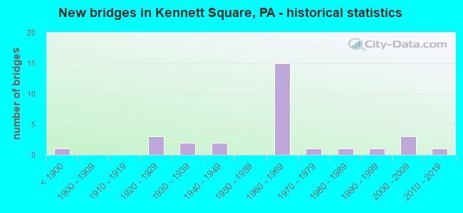
- New bridges - historical statistics
- 1Before 1900
- 31920-1929
- 21930-1939
- 21940-1949
- 151960-1969
- 11970-1979
- 11980-1989
- 11990-1999
- 32000-2009
- 12010-2019
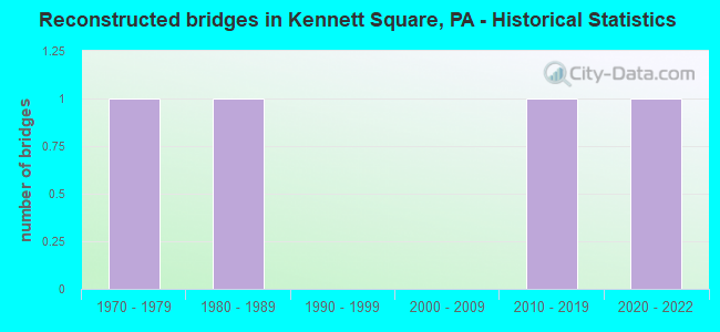
- Reconstructed bridges - Historical Statistics
- 11970-1979
- 11980-1989
- 01990-1999
- 02000-2009
- 12010-2019
- 12020-2022
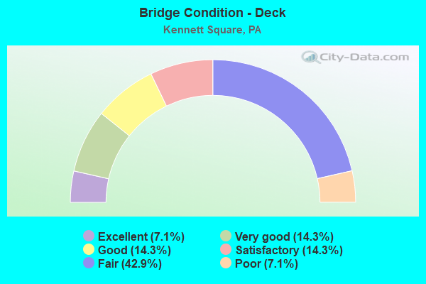
- Bridge Condition - Deck
- 7.1%Excellent
- 14.3%Very good
- 14.3%Good
- 14.3%Satisfactory
- 42.9%Fair
- 7.1%Poor
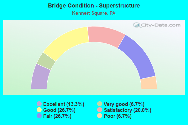
- Bridge Condition - Superstructure
- 13.3%Excellent
- 6.7%Very good
- 26.7%Good
- 20.0%Satisfactory
- 26.7%Fair
- 6.7%Poor
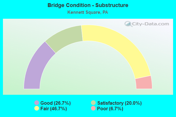
- Bridge Condition - Substructure
- 26.7%Good
- 20.0%Satisfactory
- 46.7%Fair
- 6.7%Poor
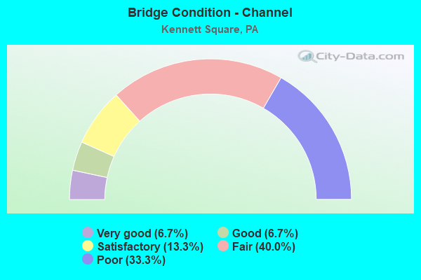
- Bridge Condition - Channel
- 6.7%Very good
- 6.7%Good
- 13.3%Satisfactory
- 40.0%Fair
- 33.3%Poor
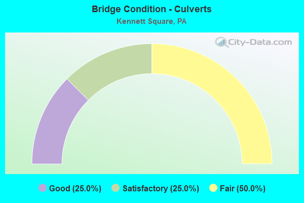
- Bridge Condition - Culverts
- 25.0%Good
- 25.0%Satisfactory
- 50.0%Fair
Find on map >> Show street view
Structure Number: 9911, Location: Near Mi Mark 20.4 47C4 (Lat: 39.853589, Lng: -75.730139), Route carried "on" structure: US 1, Year Built: 1965, Status: Open, Structure Length: 1.07m (3.51ft), Average Daily Traffic: 32,893 (year 2022), Truck Traffic: 8%, Average Future Daily Traffic: 36,255 (year 2032), Design Load: HS 20, Features Intersected: W.BRANCH RED CLAY CREEK
Minimum Vertical Clearance: 30+ m (98+ ft), Kilometerpoint: 32.778, Lanes on structure: 4, Base Highway Network: Yes, Owner: State Highway Agency, Approaching Roadway Width: 32.9m (107.9ft), Skew: 21 degrees, Material/Design: Concrete, Design/Construction: Culvert, Number Of Spans In Main Unit: 1, Length of Maximum Span: 10.7m (35.1ft)
Condition: Channel: Poor, Culverts: Fair, Operating Rating: 71.7 metric tons, Method Used To Determine Operating Rating: Field evaluation and documented engineering judgment, Inventory Rating: 42.6 metric tons, Method Used To Determine Inventory Rating: Field evaluation and documented engineering judgment, Structural Evaluation: Somewhat better than minimum adequacy, Waterway Adequacy: Superior to present desirable criteria, Approach Roadway Alignment: Equal to present desirable criteria, Length Of Structure Improvement: 1.80m (5.91ft), Designated Inspection Frequency: Every 24 months, Underwater Inspection Frequency: Every 24 months, Inspection Date: September 2021, Underwater Inspection Date: September 2021
Find on map >> Show street view
Structure Number: 10051, Location: NO. KENNETT SQUARE 47E3 (Lat: 39.856747, Lng: -75.715350), Route carried "on" structure: State highway 82, Year Built: 1965, Status: Open, Structure Length: 6.37m (20.90ft), Average Daily Traffic: 13,146 (year 2022), Truck Traffic: 7%, Average Future Daily Traffic: 17,049 (year 2032), Design Load: HS 20, Features Intersected: US 1 BY-PASS, Facility Carried by Structure: UNIONVILLE ROAD
Minimum Vertical Clearance: 30+ m (98+ ft), Kilometerpoint: 7.321, Lanes on structure: 2, Lanes under structure: 4, Owner: State Highway Agency, Approaching Roadway Width: 18.3m (60.0ft), Skew: 21 degrees, Material/Design: Prestressed concrete, Design/Construction: Box Beam or Girders - Single/Spread, Number Of Spans In Main Unit: 4, Length of Maximum Span: 19.8m (65.0ft), Curb-To-Curb Width: 17.2m (56.4ft), Out-to-Out Width: 20.0m (65.6ft)
Condition: Deck: Fair, Superstructure: Fair, Substructure: Fair, Operating Rating: 53.5 metric tons, Method Used To Determine Operating Rating: Load Factor (LF), Inventory Rating: 25.4 metric tons, Method Used To Determine Inventory Rating: Load Factor (LF), Structural Evaluation: Somewhat better than minimum adequacy, Deck Geometry: Superior to present desirable criteria, Underclear: High priority of corrective action, Approach Roadway Alignment: Equal to present desirable criteria, Length Of Structure Improvement: 7.30m (23.95ft), Designated Inspection Frequency: Every 24 months, Inspection Date: April 2020, Bridge Improvement Cost: $127,000, Roadway Improvement Cost: $375,000, Total Project Cost: $1,719,000, Deck Structure Type: Concrete Cast-file-Place, Wearing Surface/Protective System: Wearing Surface: Bituminous
Find on map >> Show street view
Structure Number: 10052, Location: KENNETT SQUARE; 47F06 (Lat: 39.842039, Lng: -75.710567), Route carried "on" structure: State highway 82, Year Built: 1932, Year Reconstructed: 1982, Status: Open, Structure Length: 1.95m (6.40ft), Average Daily Traffic: 8,095 (year 2022), Truck Traffic: 6%, Average Future Daily Traffic: 12,959 (year 2032), Design Load: HS 20, Features Intersected: EAST PENN RAILROAD, Facility Carried by Structure: UNION STREET
Minimum Vertical Clearance: 30+ m (98+ ft), Kilometerpoint: 5.478, Lanes on structure: 2, Owner: State Highway Agency, Approaching Roadway Width: 9.8m (32.2ft), Material/Design: Steel, Design/Construction: Girder and Floorbeam System, Number Of Spans In Main Unit: 1, Length of Maximum Span: 18.0m (59.1ft), Curb or Sidewalk Widths: Left: 0.0m, Right: 1.5m (4.9ft), Curb-To-Curb Width: 6.7m (22.0ft), Out-to-Out Width: 7.6m (24.9ft)
Condition: Deck: Satisfactory, Superstructure: Good, Substructure: Satisfactory, Operating Rating: 54.4 metric tons, Method Used To Determine Operating Rating: Load Factor (LF), Inventory Rating: 32.7 metric tons, Method Used To Determine Inventory Rating: Load Factor (LF), Structural Evaluation: Equal to present minimum criteria, Deck Geometry: High priority of replacement, Underclear: High priority of corrective action, Approach Roadway Alignment: Somewhat better than minimum adequacy, Length Of Structure Improvement: 2.40m (7.87ft), Designated Inspection Frequency: Every 24 months, Critical Feature Inspection Frequency: Every 24 months, Inspection Date: October 2020, Critical Feature Inspection Date: October 2020, Bridge Improvement Cost: $11,000, Roadway Improvement Cost: $32,000, Total Project Cost: $146,000, Deck Structure Type: Concrete Cast-file-Place, Wearing Surface/Protective System: Wearing Surface: Monolithic Concrete, Deck Protection: Epoxy Coated Reinforcing
Find on map >> Show street view
Structure Number: 10055, Location: 1.5MI.N.DELAWARE 47H9 (Lat: 39.826858, Lng: -75.691606), Route carried "on" structure: State highway 82, Year Built: 1938, Year Reconstructed: 2019, Status: Open, Structure Length: 1.58m (5.18ft), Average Daily Traffic: 2,901 (year 2022), Truck Traffic: 4%, Average Future Daily Traffic: 2,558 (year 2032), Design Load: HL 93, Features Intersected: EAST BR RED CLAY CREEK, Facility Carried by Structure: CREEK ROAD
Minimum Vertical Clearance: 30+ m (98+ ft), Kilometerpoint: 2.113, Lanes on structure: 2, Owner: State Highway Agency, Approaching Roadway Width: 6.7m (22.0ft), Material/Design: Steel continuous, Design/Construction: Stringer/Multi-beam, Number Of Spans In Main Unit: 2, Length of Maximum Span: 7.6m (24.9ft), Curb-To-Curb Width: 6.7m (22.0ft), Out-to-Out Width: 7.6m (24.9ft)
Condition: Deck: Very good, Superstructure: Excellent, Substructure: Good, Channel: Good, Operating Rating: 71.9 metric tons, Method Used To Determine Operating Rating: Assigned ratings based on Load and Resistance Factor Design (LRFD) reported by rating factor (RF) using HL93 loadings, Inventory Rating: 55.4 metric tons, Method Used To Determine Inventory Rating: Assigned ratings based on Load and Resistance Factor Design (LRFD) reported by rating factor (RF) using HL93 loadings, Structural Evaluation: Better than present minimum criteria, Deck Geometry: High priority of replacement, Waterway Adequacy: Equal to present minimum criteria, Approach Roadway Alignment: Somewhat better than minimum adequacy, Length Of Structure Improvement: 2.10m (6.89ft), Designated Inspection Frequency: Every 24 months, Inspection Date: July 2021, Bridge Improvement Cost: $19,000, Roadway Improvement Cost: $55,000, Total Project Cost: $254,000, Deck Structure Type: Closed Grating, Wearing Surface/Protective System: Wearing Surface: Monolithic Concrete, Deck Protection: Galvanized Reinforcing
Find on map >> Show street view
Structure Number: 10439, Location: 1MI.CLIFTON MILL 47G06 (Lat: 39.841242, Lng: -75.702864), Route carried "on" structure: Spur State highway , Year Built: 1923, Status: Open, Structure Length: 1.28m (4.20ft), Average Daily Traffic: 2,385 (year 2020), Truck Traffic: 5%, Average Future Daily Traffic: 3,499 (year 2032), Design Load: H 20, Features Intersected: EAST BRANCH RED CLAY CR., Facility Carried by Structure: WALNUT STREET
Minimum Vertical Clearance: 30+ m (98+ ft), Kilometerpoint: 0.000, Lanes on structure: 2, Owner: State Highway Agency, Approaching Roadway Width: 9.1m (29.9ft), Material/Design: Concrete continuous, Design/Construction: Slab, Number Of Spans In Main Unit: 2, Length of Maximum Span: 6.1m (20.0ft), Curb-To-Curb Width: 9.1m (29.9ft), Out-to-Out Width: 10.1m (33.1ft)
Condition: Deck: Fair, Superstructure: Fair, Substructure: Satisfactory, Channel: Poor, Operating Rating: 62.6 metric tons, Method Used To Determine Operating Rating: Field evaluation and documented engineering judgment, Inventory Rating: 37.2 metric tons, Method Used To Determine Inventory Rating: Field evaluation and documented engineering judgment, Structural Evaluation: Somewhat better than minimum adequacy, Deck Geometry: Meets minimum limits, Waterway Adequacy: Equal to present minimum criteria, Approach Roadway Alignment: Equal to present desirable criteria, Length Of Structure Improvement: 1.90m (6.23ft), Designated Inspection Frequency: Every 24 months, Inspection Date: August 2020, Bridge Improvement Cost: $49,000, Roadway Improvement Cost: $145,000, Total Project Cost: $665,000, Deck Structure Type: Concrete Cast-file-Place, Wearing Surface/Protective System: Wearing Surface: Bituminous
Find on map >> Show street view
Structure Number: 10481, Location: KENNETT SQUARE 47F06 (Lat: 39.841958, Lng: -75.707114), Route carried "on" structure: State highway , Year Built: 1926, Status: Open, Structure Length: 1.49m (4.89ft), Average Daily Traffic: 1,569 (year 2021), Truck Traffic: 7%, Average Future Daily Traffic: 2,761 (year 2032), Design Load: H 15, Features Intersected: EAST BRANCH RED CLAY CR., Facility Carried by Structure: BIRCH STREET
Minimum Vertical Clearance: 30+ m (98+ ft), Kilometerpoint: 0.000, Lanes on structure: 2, Owner: State Highway Agency, Approaching Roadway Width: 10.1m (33.1ft), Material/Design: Concrete continuous, Design/Construction: Slab, Number Of Spans In Main Unit: 2, Length of Maximum Span: 6.1m (20.0ft), Curb or Sidewalk Widths: Left: 1.5m (4.9ft), Right: 1.5m (4.9ft), Curb-To-Curb Width: 10.1m (33.1ft), Out-to-Out Width: 14.3m (46.9ft)
Condition: Deck: Poor, Superstructure: Poor, Substructure: Poor, Channel: Poor, Operating Rating: 61.7 metric tons, Method Used To Determine Operating Rating: Load Factor (LF), Inventory Rating: 37.2 metric tons, Method Used To Determine Inventory Rating: Load Factor (LF), Structural Evaluation: Meets minimum limits, Deck Geometry: Somewhat better than minimum adequacy, Waterway Adequacy: Better than present minimum criteria, Approach Roadway Alignment: Equal to present desirable criteria, Length Of Structure Improvement: 1.90m (6.23ft), Designated Inspection Frequency: Every 24 months, Inspection Date: August 2020, Bridge Improvement Cost: $45,000, Roadway Improvement Cost: $134,000, Total Project Cost: $612,000, Deck Structure Type: Concrete Cast-file-Place, Wearing Surface/Protective System: Wearing Surface: Bituminous
Find on map >> Show street view
Structure Number: 10502, Location: 1MI.S.KENNETT SQ. 47D05 (Lat: 39.844364, Lng: -75.721425), Route carried "on" structure: State highway , Year Built: 1940, Status: Open, Structure Length: 1.52m (4.99ft), Average Daily Traffic: 5,441 (year 2021), Truck Traffic: 6%, Average Future Daily Traffic: 9,174 (year 2032), Design Load: H 20, Features Intersected: WEST BR.RED CLAY CREEK, Facility Carried by Structure: WEST CYPRESS ST
Minimum Vertical Clearance: 30+ m (98+ ft), Kilometerpoint: 4.931, Lanes on structure: 2, Owner: State Highway Agency, Approaching Roadway Width: 12.8m (42.0ft), Skew: 2 degrees, Material/Design: Concrete, Design/Construction: Tee Beam, Number Of Spans In Main Unit: 1, Length of Maximum Span: 11.3m (37.1ft), Curb or Sidewalk Widths: Left: 1.5m (4.9ft), Right: 1.5m (4.9ft), Curb-To-Curb Width: 12.3m (40.4ft), Out-to-Out Width: 16.2m (53.1ft)
Condition: Deck: Fair, Superstructure: Satisfactory, Substructure: Fair, Channel: Poor, Operating Rating: 56.2 metric tons, Method Used To Determine Operating Rating: Load Factor (LF), Inventory Rating: 33.6 metric tons, Method Used To Determine Inventory Rating: Load Factor (LF), Structural Evaluation: Somewhat better than minimum adequacy, Deck Geometry: Better than present minimum criteria, Waterway Adequacy: Equal to present minimum criteria, Approach Roadway Alignment: Equal to present desirable criteria, Length Of Structure Improvement: 2.10m (6.89ft), Designated Inspection Frequency: Every 24 months, Underwater Inspection Frequency: Every 24 months, Inspection Date: October 2020, Underwater Inspection Date: September 2021, Bridge Improvement Cost: $33,000, Roadway Improvement Cost: $96,000, Total Project Cost: $442,000, Deck Structure Type: Concrete Cast-file-Place, Wearing Surface/Protective System: Wearing Surface: Bituminous
Find on map >> Show street view
Structure Number: 10503, Location: 4 MI. TO YORKLYN 47F5 (Lat: 39.846464, Lng: -75.706256), Route carried "on" structure: State highway , Year Built: 1940, Status: Open, Structure Length: 1.28m (4.20ft), Average Daily Traffic: 7,447 (year 2022), Truck Traffic: 3%, Average Future Daily Traffic: 11,951 (year 2032), Design Load: H 20, Features Intersected: EAST BR.RED CLAY CREEK, Facility Carried by Structure: EAST CYPRESS STR.
Minimum Vertical Clearance: 30+ m (98+ ft), Kilometerpoint: 5.749, Lanes on structure: 2, Owner: State Highway Agency, Approaching Roadway Width: 9.4m (30.8ft), Material/Design: Concrete, Design/Construction: Tee Beam, Number Of Spans In Main Unit: 1, Length of Maximum Span: 12.5m (41.0ft), Curb or Sidewalk Widths: Left: 1.5m (4.9ft), Right: 1.5m (4.9ft), Curb-To-Curb Width: 9.5m (31.2ft), Out-to-Out Width: 13.6m (44.6ft)
Condition: Deck: Fair, Superstructure: Fair, Substructure: Fair, Channel: Poor, Operating Rating: 62.6 metric tons, Method Used To Determine Operating Rating: Load Factor (LF), Inventory Rating: 37.2 metric tons, Method Used To Determine Inventory Rating: Load Factor (LF), Structural Evaluation: Somewhat better than minimum adequacy, Deck Geometry: Meets minimum limits, Waterway Adequacy: Equal to present desirable criteria, Approach Roadway Alignment: Equal to present desirable criteria, Length Of Structure Improvement: 1.90m (6.23ft), Designated Inspection Frequency: Every 24 months, Inspection Date: April 2020, Bridge Improvement Cost: $6,000, Roadway Improvement Cost: $18,000, Total Project Cost: $83,000, Deck Structure Type: Concrete Cast-file-Place, Wearing Surface/Protective System: Wearing Surface: Bituminous
Find on map >> Show street view
Structure Number: 10507, Location: NEAR KENNETT SQUARE 47D5 (Lat: 39.845361, Lng: -75.721500), Route carried "on" structure: State highway , Year Built: 1929, Year Reconstructed: 2020, Status: Open, Structure Length: 1.19m (3.90ft), Average Daily Traffic: 5,759 (year 2022), Truck Traffic: 8%, Average Future Daily Traffic: 9,833 (year 2032), Design Load: HL 93, Features Intersected: WEST BR. RED CLAY CREEK, Facility Carried by Structure: WEST STATE STREET
Minimum Vertical Clearance: 30+ m (98+ ft), Kilometerpoint: 4.920, Lanes on structure: 2, Owner: State Highway Agency, Approaching Roadway Width: 12.2m (40.0ft), Skew: 1 degrees, Material/Design: Prestressed concrete, Design/Construction: Box Beam or Girders - Single/Spread, Number Of Spans In Main Unit: 1, Length of Maximum Span: 11.3m (37.1ft), Curb or Sidewalk Widths: Left: 2.2m (7.2ft), Right: 1.3m (4.3ft), Curb-To-Curb Width: 11.6m (38.1ft), Out-to-Out Width: 16.2m (53.1ft)
Condition: Deck: Excellent, Superstructure: Excellent, Substructure: Fair, Channel: Satisfactory, Operating Rating: 45.0 metric tons, Method Used To Determine Operating Rating: Assigned ratings based on Load and Resistance Factor Design (LRFD) reported by rating factor (RF) using HL93 loadings, Inventory Rating: 34.7 metric tons, Method Used To Determine Inventory Rating: Assigned ratings based on Load and Resistance Factor Design (LRFD) reported by rating factor (RF) using HL93 loadings, Structural Evaluation: Somewhat better than minimum adequacy, Deck Geometry: Better than present minimum criteria, Waterway Adequacy: Better than present minimum criteria, Approach Roadway Alignment: Equal to present desirable criteria, Length Of Structure Improvement: 1.80m (5.91ft), Designated Inspection Frequency: Every 24 months, Inspection Date: September 2020, Bridge Improvement Cost: $19,000, Roadway Improvement Cost: $57,000, Total Project Cost: $260,000, Deck Structure Type: Concrete Cast-file-Place, Wearing Surface/Protective System: Wearing Surface: Monolithic Concrete, Deck Protection: Epoxy Coated Reinforcing
Find on map >> Show street view
Structure Number: 10508, Location: 1 MI. ROUTE 131 SP E 47F5 (Lat: 39.848700, Lng: -75.706278), Route carried "on" structure: State highway , Year Built: 1962, Status: Open, Structure Length: 1.22m (4.00ft), Average Daily Traffic: 10,483 (year 2022), Truck Traffic: 5%, Average Future Daily Traffic: 12,370 (year 2032), Design Load: HS 20, Features Intersected: EAST BR. RED CLAY CREEK, Facility Carried by Structure: EAST STATE STREET
Minimum Vertical Clearance: 30+ m (98+ ft), Kilometerpoint: 5.835, Lanes on structure: 2, Owner: State Highway Agency, Approaching Roadway Width: 15.2m (49.9ft), Material/Design: Prestressed concrete, Design/Construction: Box Beam or Girders - Single/Spread, Number Of Spans In Main Unit: 1, Length of Maximum Span: 12.2m (40.0ft), Curb or Sidewalk Widths: Left: 1.5m (4.9ft), Right: 1.5m (4.9ft), Curb-To-Curb Width: 11.1m (36.4ft), Out-to-Out Width: 14.8m (48.6ft)
Condition: Deck: Fair, Superstructure: Fair, Substructure: Fair, Channel: Fair, Operating Rating: 75.3 metric tons, Method Used To Determine Operating Rating: Load Factor (LF), Inventory Rating: 39.9 metric tons, Method Used To Determine Inventory Rating: Load Factor (LF), Structural Evaluation: Somewhat better than minimum adequacy, Deck Geometry: Equal to present minimum criteria, Waterway Adequacy: Equal to present desirable criteria, Approach Roadway Alignment: Equal to present desirable criteria, Length Of Structure Improvement: 1.90m (6.23ft), Designated Inspection Frequency: Every 24 months, Underwater Inspection Frequency: Every 24 months, Inspection Date: April 2020, Underwater Inspection Date: April 2020, Deck Structure Type: Concrete Cast-file-Place, Wearing Surface/Protective System: Wearing Surface: Monolithic Concrete
Find on map >> Show street view
Structure Number: 10509, Location: EAST KENNETT SQ. 47H03 (Lat: 39.857467, Lng: -75.692283), Route carried "on" structure: State highway , Year Built: 1965, Status: Open, Structure Length: 3.38m (11.09ft), Average Daily Traffic: 6,837 (year 2022), Truck Traffic: 6%, Average Future Daily Traffic: 8,826 (year 2032), Design Load: HS 20, Features Intersected: US 1 BY-PASS, Facility Carried by Structure: BALTIMORE PIKE
Minimum Vertical Clearance: 30+ m (98+ ft), Kilometerpoint: 7.026, Lanes on structure: 1, Lanes under structure: 4, Owner: State Highway Agency, Approaching Roadway Width: 9.1m (29.9ft), Skew: 4 degrees, Material/Design: Steel, Design/Construction: Stringer/Multi-beam, Number Of Spans In Main Unit: 1, Length of Maximum Span: 32.3m (106.0ft), Curb or Sidewalk Widths: Left: 0.5m (1.6ft), Right: 0.5m (1.6ft), Curb-To-Curb Width: 7.9m (25.9ft), Out-to-Out Width: 9.6m (31.5ft)
Condition: Deck: Satisfactory, Superstructure: Good, Substructure: Fair, Operating Rating: 78.9 metric tons, Method Used To Determine Operating Rating: Load Factor (LF), Inventory Rating: 47.2 metric tons, Method Used To Determine Inventory Rating: Load Factor (LF), Structural Evaluation: Somewhat better than minimum adequacy, Deck Geometry: High priority of replacement, Underclear: High priority of corrective action, Approach Roadway Alignment: Better than present minimum criteria, Length Of Structure Improvement: 4.20m (13.78ft), Designated Inspection Frequency: Every 24 months, Inspection Date: August 2020, Deck Structure Type: Concrete Cast-file-Place, Wearing Surface/Protective System: Wearing Surface: Monolithic Concrete
Find on map >> Show street view
Structure Number: 10661, Location: KENNETT TOWNSHIP 47C06 (Lat: 39.837775, Lng: -75.725344), Route carried "on" structure: City street , Year Built: 1980, Status: Open, Structure Length: 1.68m (5.51ft), Average Daily Traffic: 4,267 (year 2019), Truck Traffic: 9%, Average Future Daily Traffic: 5,207 (year 2039), Design Load: HS 20, Features Intersected: WEST BR RED CLAY CREEK, Facility Carried by Structure: WEST SOUTH STREET
Minimum Vertical Clearance: 30+ m (98+ ft), Kilometerpoint: 0.000, Lanes on structure: 2, Owner: County Highway Agency, Approaching Roadway Width: 8.5m (27.9ft), Material/Design: Prestressed concrete, Design/Construction: Box Beam or Girders - Multiple, Number Of Spans In Main Unit: 1, Length of Maximum Span: 16.5m (54.1ft), Curb-To-Curb Width: 8.5m (27.9ft), Out-to-Out Width: 9.6m (31.5ft)
Condition: Deck: Good, Superstructure: Satisfactory, Substructure: Satisfactory, Channel: Fair, Operating Rating: 72.6 metric tons, Method Used To Determine Operating Rating: Load Factor (LF), Inventory Rating: 28.1 metric tons, Method Used To Determine Inventory Rating: Load Factor (LF), Structural Evaluation: Equal to present minimum criteria, Deck Geometry: Meets minimum limits, Waterway Adequacy: Better than present minimum criteria, Approach Roadway Alignment: Equal to present desirable criteria, Length Of Structure Improvement: 2.40m (7.87ft), Designated Inspection Frequency: Every 24 months, Inspection Date: July 2020, Deck Structure Type: Concrete Cast-file-Place, Wearing Surface/Protective System: Wearing Surface: Monolithic Concrete, Deck Protection: Epoxy Coated Reinforcing
Find on map >> Show street view
Structure Number: 10679, Location: E.MARLBORO TWP. 47B03 (Lat: 39.858753, Lng: -75.732167), Route carried "on" structure: City street , Year Built: 1889, Year Reconstructed: 1992, Status: Posted for load, Structure Length: 1.83m (6.00ft), Average Daily Traffic: 659 (year 2018), Truck Traffic: 3%, Average Future Daily Traffic: 725 (year 2023), Design Load: HS 20, Features Intersected: WEST BR RED CLAY CREEK, Facility Carried by Structure: MILL ROAD(T402)
Minimum Vertical Clearance: 30+ m (98+ ft), Kilometerpoint: 0.000, Lanes on structure: 1, Owner: County Highway Agency, Approaching Roadway Width: 5.2m (17.1ft), Skew: 1 degrees, Material/Design: Steel, Design/Construction: Stringer/Multi-beam, Number Of Spans In Main Unit: 1, Length of Maximum Span: 18.3m (60.0ft), Curb-To-Curb Width: 4.0m (13.1ft), Out-to-Out Width: 5.0m (16.4ft)
Condition: Deck: Fair, Superstructure: Satisfactory, Substructure: Fair, Channel: Fair, Operating Rating: 73.5 metric tons, Method Used To Determine Operating Rating: Load Factor (LF), Inventory Rating: 43.5 metric tons, Method Used To Determine Inventory Rating: Load Factor (LF), Structural Evaluation: Somewhat better than minimum adequacy, Deck Geometry: High priority of replacement, Waterway Adequacy: Equal to present desirable criteria, Approach Roadway Alignment: Meets minimum limits, Length Of Structure Improvement: 1.60m (5.25ft), Designated Inspection Frequency: Every 24 months, Other Special Inspection Frequency: Every 12 months, Inspection Date: July 2020, Other Special Inspection Date: July 2021, Deck Structure Type: Open Grating, Wearing Surface/Protective System: Wearing Surface: Wood or Timber
Find on map >> Show street view
Structure Number: 10793, Location: 0.4 MI SW OF SR01 3801-E5 (Lat: 39.849875, Lng: -75.724394), Route carried "on" structure: City street , Year Built: 2004, Status: Open, Structure Length: 0.73m (2.40ft), Average Daily Traffic: 420 (year 2012), Average Future Daily Traffic: 540 (year 2032), Design Load: HS 20, Features Intersected: W.BR.RED CLAY CREEK, Facility Carried by Structure: PEMBERTON ROAD
Minimum Vertical Clearance: 30+ m (98+ ft), Kilometerpoint: 0.000, Lanes on structure: 2, Owner: Town or Township Highway Agency, Approaching Roadway Width: 6.4m (21.0ft), Material/Design: Concrete, Design/Construction: Arch - Deck, Number Of Spans In Main Unit: 1, Length of Maximum Span: 7.3m (24.0ft), Curb-To-Curb Width: 6.4m (21.0ft), Out-to-Out Width: 7.3m (24.0ft)
Condition: Superstructure: Good, Substructure: Good, Channel: Fair, Operating Rating: 78.0 metric tons, Method Used To Determine Operating Rating: Load Factor (LF), Inventory Rating: 59.9 metric tons, Method Used To Determine Inventory Rating: Load Factor (LF), Structural Evaluation: Better than present minimum criteria, Deck Geometry: High priority of corrective action, Waterway Adequacy: Meets minimum limits, Approach Roadway Alignment: Equal to present desirable criteria, Length Of Structure Improvement: 1.10m (3.61ft), Designated Inspection Frequency: Every 24 months, Inspection Date: April 2020, Bridge Improvement Cost: $15,000, Roadway Improvement Cost: $45,000, Total Project Cost: $205,000
Find on map >> Show street view
Structure Number: 10808, Location: 0.7 MI N SR52 ADC 3692-C7 (Lat: 39.898000, Lng: -75.670633), Route carried "on" structure: State highway , Year Built: 1966, Status: Open, Structure Length: 0.67m (2.20ft), Average Daily Traffic: 750 (year 2017), Truck Traffic: 1%, Average Future Daily Traffic: 1,000 (year 2037), Design Load: HS 20, Features Intersected: BRANCH POCOPSON CREEK, Facility Carried by Structure: LOCUST GROVE ROAD
Minimum Vertical Clearance: 30+ m (98+ ft), Kilometerpoint: 0.000, Lanes on structure: 2, Owner: Town or Township Highway Agency, Approaching Roadway Width: 9.8m (32.2ft), Material/Design: Concrete, Design/Construction: Culvert, Number Of Spans In Main Unit: 1, Length of Maximum Span: 6.1m (20.0ft)
Condition: Channel: Fair, Culverts: Satisfactory, Operating Rating: 54.4 metric tons, Method Used To Determine Operating Rating: Load Factor (LF), Inventory Rating: 32.7 metric tons, Method Used To Determine Inventory Rating: Load Factor (LF), Structural Evaluation: Equal to present minimum criteria, Waterway Adequacy: Better than present minimum criteria, Approach Roadway Alignment: Equal to present desirable criteria, Length Of Structure Improvement: 1.30m (4.27ft), Designated Inspection Frequency: Every 24 months, Inspection Date: June 2020
Find on map >> Show street view
Structure Number: 10809, Location: 1.0 MI S OF SR842 3692-A7 (Lat: 39.898606, Lng: -75.706761), Route carried "on" structure: State highway , Year Built: 1970, Status: Open, Structure Length: 0.91m (2.99ft), Average Daily Traffic: 850 (year 2015), Truck Traffic: 1%, Average Future Daily Traffic: 1,000 (year 2035), Design Load: HS 20, Features Intersected: POCOPSON CREEK, Facility Carried by Structure: MARLBORO ROAD
Minimum Vertical Clearance: 30+ m (98+ ft), Kilometerpoint: 0.000, Lanes on structure: 2, Owner: Town or Township Highway Agency, Approaching Roadway Width: 6.7m (22.0ft), Skew: 3 degrees, Material/Design: Concrete, Design/Construction: Culvert, Number Of Spans In Main Unit: 1, Length of Maximum Span: 8.5m (27.9ft)
Condition: Channel: Fair, Culverts: Good, Operating Rating: 40.8 metric tons, Method Used To Determine Operating Rating: Load Factor (LF), Inventory Rating: 24.5 metric tons, Method Used To Determine Inventory Rating: Load Factor (LF), Structural Evaluation: Equal to present minimum criteria, Waterway Adequacy: Better than present minimum criteria, Approach Roadway Alignment: Equal to present desirable criteria, Length Of Structure Improvement: 1.60m (5.25ft), Designated Inspection Frequency: Every 24 months, Inspection Date: July 2020
Find on map >> Show street view
Structure Number: 41513, Location: ADL LONGWOOD GARD 39K12 (Lat: 39.878253, Lng: -75.681292), Route carried "on" structure: State highway 926, Year Built: 2001, Status: Open, Structure Length: 1.01m (3.31ft), Average Daily Traffic: 9,207 (year 2022), Truck Traffic: 5%, Average Future Daily Traffic: 10,904 (year 2032), Design Load: HS 25 or greater, Features Intersected: LONGWOOD GARDENS ACCESS, Facility Carried by Structure: STREET ROAD
Minimum Vertical Clearance: 30+ m (98+ ft), Kilometerpoint: 21.984, Lanes on structure: 2, Lanes under structure: 2, Owner: State Highway Agency, Approaching Roadway Width: 11.0m (36.1ft), Material/Design: Prestressed concrete, Design/Construction: Box Beam or Girders - Single/Spread, Number Of Spans In Main Unit: 1, Length of Maximum Span: 9.8m (32.2ft), Curb or Sidewalk Widths: Left: 0.2m (0.7ft), Right: 0.2m (0.7ft), Curb-To-Curb Width: 10.9m (35.8ft), Out-to-Out Width: 11.9m (39.0ft)
Condition: Deck: Good, Superstructure: Good, Substructure: Good, Operating Rating: 68.0 metric tons, Method Used To Determine Operating Rating: Load Factor (LF), Inventory Rating: 40.8 metric tons, Method Used To Determine Inventory Rating: Load Factor (LF), Structural Evaluation: Better than present minimum criteria, Deck Geometry: Meets minimum limits, Underclear: High priority of corrective action, Approach Roadway Alignment: Equal to present desirable criteria, Length Of Structure Improvement: 1.60m (5.25ft), Designated Inspection Frequency: Every 24 months, Inspection Date: April 2020, Deck Structure Type: Concrete Cast-file-Place, Wearing Surface/Protective System: Wearing Surface: Monolithic Concrete, Deck Protection: Epoxy Coated Reinforcing
Find on map >> Show street view
Structure Number: 47014, Location: .5 MI. N. U.S. 1 40B12 (Lat: 39.874750, Lng: -75.661656), Route carried "on" structure: State highway 52, Year Built: 2011, Status: Open, Structure Length: 15.39m (50.49ft), Average Daily Traffic: 17,502 (year 2022), Truck Traffic: 8%, Average Future Daily Traffic: 16,774 (year 2032), Design Load: HL 93, Features Intersected: BENNETT'S RUN POND, Facility Carried by Structure: LENAPE ROAD
Minimum Vertical Clearance: 30+ m (98+ ft), Kilometerpoint: 5.470, Lanes on structure: 2, Owner: State Highway Agency, Approaching Roadway Width: 14.6m (47.9ft), Material/Design: Prestressed concrete continuous, Design/Construction: Stringer/Multi-beam, Number Of Spans In Main Unit: 4, Length of Maximum Span: 38.1m (125.0ft), Curb or Sidewalk Widths: Left: 0.2m (0.7ft), Right: 0.2m (0.7ft), Curb-To-Curb Width: 14.8m (48.6ft), Out-to-Out Width: 15.8m (51.8ft)
Condition: Deck: Very good, Superstructure: Very good, Substructure: Good, Channel: Very good, Operating Rating: 56.1 metric tons, Method Used To Determine Operating Rating: Assigned ratings based on Load and Resistance Factor Design (LRFD) reported by rating factor (RF) using HL93 loadings, Inventory Rating: 35.0 metric tons, Method Used To Determine Inventory Rating: Assigned ratings based on Load and Resistance Factor Design (LRFD) reported by rating factor (RF) using HL93 loadings, Structural Evaluation: Better than present minimum criteria, Deck Geometry: Superior to present desirable criteria, Waterway Adequacy: Superior to present desirable criteria, Approach Roadway Alignment: Equal to present desirable criteria, Designated Inspection Frequency: Every 24 months, Inspection Date: June 2020, Deck Structure Type: Concrete Cast-file-Place, Wearing Surface/Protective System: Wearing Surface: Monolithic Concrete, Membrane: Other, Deck Protection: Epoxy Coated Reinforcing
Find on map >> Show street view
Structure Number: 54178, Location: N OF CANTERBURY DR3802B03 (Lat: 39.858947, Lng: -75.678647), Route carried "on" structure: City street , Year Built: 1992, Status: Open, Structure Length: 0.73m (2.40ft), Average Daily Traffic: 1,500 (year 2017), Truck Traffic: 2%, Average Future Daily Traffic: 2,000 (year 2037), Design Load: HS 20, Features Intersected: EAST BR. RED CLAY CREEK, Facility Carried by Structure: BAYARD ROAD
Minimum Vertical Clearance: 30+ m (98+ ft), Kilometerpoint: 0.000, Lanes on structure: 2, Owner: Town or Township Highway Agency, Approaching Roadway Width: 6.7m (22.0ft), Skew: 1 degrees, Material/Design: Concrete, Design/Construction: Culvert, Number Of Spans In Main Unit: 2, Length of Maximum Span: 3.4m (11.2ft), Curb-To-Curb Width: 14.6m (47.9ft), Out-to-Out Width: 16.2m (53.1ft)
Condition: Channel: Satisfactory, Culverts: Fair, Operating Rating: 52.6 metric tons, Method Used To Determine Operating Rating: Field evaluation and documented engineering judgment, Inventory Rating: 30.8 metric tons, Method Used To Determine Inventory Rating: Field evaluation and documented engineering judgment, Structural Evaluation: Somewhat better than minimum adequacy, Deck Geometry: Superior to present desirable criteria, Waterway Adequacy: Better than present minimum criteria, Approach Roadway Alignment: Equal to present desirable criteria, Designated Inspection Frequency: Every 24 months, Inspection Date: March 2021, Wearing Surface/Protective System: Wearing Surface: Bituminous
Find on map >> Show street view
Structure Number: 9912, Location: NW KENNETT SQUARE 47C4 (Lat: 39.853958, Lng: -75.728328), Route carried "under" structure: County highway , Year Built: 1965, Structure Length: 0. m, Average Daily Traffic: 1,800 (year 1980), Truck Traffic: 7%, Features Intersected: MILL ROAD (T-432), Facility Carried by Structure: US-1 BYPASS (NB)
Minimum Vertical Clearance: 4.37m (14.34ft), Kilometerpoint: 0.000, Lanes on structure: 2, Lanes under structure: 2, Material/Design: Prestressed concrete, Design/Construction: Box Beam or Girders - Single/Spread, Length of Maximum Span: 12.8m (42.0ft)
Find on map >> Show street view
Structure Number: 9913, Location: NW KENNETT SQUARE 47C4 (Lat: 39.854111, Lng: -75.728694), Route carried "under" structure: County highway , Year Built: 1965, Structure Length: 0. m, Average Daily Traffic: 1,800 (year 1980), Truck Traffic: 7%, Features Intersected: MILL ROAD (T-432), Facility Carried by Structure: US-1 BYPASS (SB)
Minimum Vertical Clearance: 4.42m (14.50ft), Kilometerpoint: 0.000, Lanes on structure: 2, Lanes under structure: 2, Material/Design: Prestressed concrete, Design/Construction: Box Beam or Girders - Single/Spread, Length of Maximum Span: 12.8m (42.0ft)
Find on map >> Show street view
Structure Number: 9915, Location: NO. KENNETT SQUARE 47G3 (Lat: 39.856856, Lng: -75.703542), Route carried "under" structure: US 1, Year Built: 1965, Structure Length: 0. m, Average Daily Traffic: 13,063 (year 2022), Truck Traffic: 11%, Features Intersected: US-1 BY-PASS, Facility Carried by Structure: WALNUT ROAD (T422)
Minimum Vertical Clearance: 4.67m (15.32ft), Kilometerpoint: 35.129, Lanes on structure: 2, Lanes under structure: 2, Material/Design: Prestressed concrete, Design/Construction: Stringer/Multi-beam, Length of Maximum Span: 20.4m (66.9ft)
Find on map >> Show street view
Structure Number: 9915, Location: NO. KENNETT SQUARE 47G3 (Lat: 39.856856, Lng: -75.703542), Route carried "under" structure: US 1, Year Built: 1965, Structure Length: 0. m, Average Daily Traffic: 14,235 (year 2022), Truck Traffic: 11%, Features Intersected: US-1 BY-PASS, Facility Carried by Structure: WALNUT ROAD (T422)
Minimum Vertical Clearance: 4.42m (14.50ft), Kilometerpoint: 35.113, Lanes on structure: 2, Lanes under structure: 2, Material/Design: Prestressed concrete, Design/Construction: Stringer/Multi-beam, Length of Maximum Span: 20.4m (66.9ft)
Find on map >> Show street view
Structure Number: 9918, Location: AT ROUTE 52 48B01 (Lat: 39.867944, Lng: -75.670333), Route carried "under" structure: US 1, Year Built: 1962, Structure Length: 0. m, Average Daily Traffic: 18,720 (year 2022), Truck Traffic: 12%, Features Intersected: BALTIMORE PIKE, Facility Carried by Structure: LONGWOOD GDNS RAMP
Minimum Vertical Clearance: 5.46m (17.91ft), Kilometerpoint: 38.199, Lanes on structure: 2, Lanes under structure: 3, Material/Design: Concrete, Design/Construction: Arch - Deck, Length of Maximum Span: 36.3m (119.1ft)
Find on map >> Show street view
Structure Number: 9918, Location: AT ROUTE 52 48B01 (Lat: 39.867944, Lng: -75.670333), Route carried "under" structure: US 1, Year Built: 1962, Structure Length: 0. m, Average Daily Traffic: 17,581 (year 2022), Truck Traffic: 9%, Features Intersected: BALTIMORE PIKE, Facility Carried by Structure: LONGWOOD GDNS RAMP
Minimum Vertical Clearance: 5.46m (17.91ft), Kilometerpoint: 38.211, Lanes on structure: 2, Lanes under structure: 4, Material/Design: Concrete, Design/Construction: Arch - Deck, Length of Maximum Span: 36.3m (119.1ft)
Find on map >> Show street view
Structure Number: 10051, Location: NO. KENNETT SQUARE 47E3 (Lat: 39.856747, Lng: -75.715350), Route carried "under" structure: US 1, Year Built: 1965, Structure Length: 0. m, Average Daily Traffic: 14,235 (year 2022), Truck Traffic: 11%, Features Intersected: US 1 BY-PASS, Facility Carried by Structure: UNIONVILLE ROAD
Minimum Vertical Clearance: 5.21m (17.09ft), Kilometerpoint: 34.100, Lanes on structure: 2, Lanes under structure: 2, Material/Design: Prestressed concrete, Design/Construction: Box Beam or Girders - Single/Spread, Length of Maximum Span: 19.8m (65.0ft)
Find on map >> Show street view
Structure Number: 10051, Location: NO. KENNETT SQUARE 47E3 (Lat: 39.856747, Lng: -75.715350), Route carried "under" structure: US 1, Year Built: 1965, Structure Length: 0. m, Average Daily Traffic: 13,063 (year 2022), Truck Traffic: 11%, Features Intersected: US 1 BY-PASS, Facility Carried by Structure: UNIONVILLE ROAD
Minimum Vertical Clearance: 4.72m (15.49ft), Kilometerpoint: 34.107, Lanes on structure: 2, Lanes under structure: 2, Material/Design: Prestressed concrete, Design/Construction: Box Beam or Girders - Single/Spread, Length of Maximum Span: 19.8m (65.0ft)
Find on map >> Show street view
Structure Number: 10509, Location: EAST KENNETT SQ. 47H03 (Lat: 39.857467, Lng: -75.692283), Route carried "under" structure: US 1, Year Built: 1965, Structure Length: 0. m, Average Daily Traffic: 14,235 (year 2022), Truck Traffic: 11%, Features Intersected: US 1 BY-PASS, Facility Carried by Structure: BALTIMORE PIKE
Minimum Vertical Clearance: 4.62m (15.16ft), Kilometerpoint: 35.692, Lanes on structure: 1, Lanes under structure: 2, Material/Design: Steel, Design/Construction: Stringer/Multi-beam, Length of Maximum Span: 32.3m (106.0ft)
Find on map >> Show street view
Structure Number: 10509, Location: EAST KENNETT SQ. 47H03 (Lat: 39.857467, Lng: -75.692283), Route carried "under" structure: US 1, Year Built: 1965, Structure Length: 0. m, Average Daily Traffic: 13,063 (year 2022), Truck Traffic: 11%, Features Intersected: US 1 BY-PASS, Facility Carried by Structure: BALTIMORE PIKE
Minimum Vertical Clearance: 5.26m (17.26ft), Kilometerpoint: 35.710, Lanes on structure: 1, Lanes under structure: 2, Material/Design: Steel, Design/Construction: Stringer/Multi-beam, Length of Maximum Span: 32.3m (106.0ft)
Find on map >> Show street view
Structure Number: 41513, Location: ADL LONGWOOD GARD 39K12 (Lat: 39.878253, Lng: -75.681292), Route carried "under" structure: ServiceOther road , Year Built: 2001, Structure Length: 0. m, Average Daily Traffic: 500 (year 2006), Truck Traffic: 7%, Features Intersected: LONGWOOD GARDENS ACCESS, Facility Carried by Structure: STREET ROAD
Minimum Vertical Clearance: 3.81m (12.50ft), Kilometerpoint: 0.000, Lanes on structure: 2, Lanes under structure: 2, Material/Design: Prestressed concrete, Design/Construction: Box Beam or Girders - Single/Spread, Length of Maximum Span: 9.8m (32.2ft)