Bridge Statistics for Kearny, New Jersey (NJ)
Condition, Traffic, Stress, Structural Evaluation, Project Costs
- National Bridge Inventory (NBI) Statistics
- 36Number of bridges
- 1,407ft / 429mTotal length
- $10,456,000Total costs
- 1,659,387Total average daily traffic
- 198,908Total average daily truck traffic
- National Bridge Inventory (NBI) Registered Bridges for Kearny
- No street view available for this location
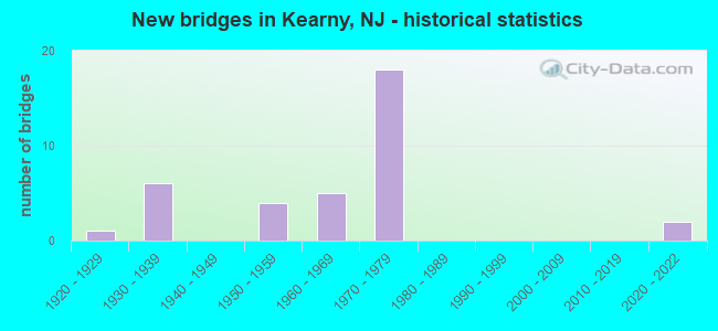
- New bridges - historical statistics
- 11920-1929
- 61930-1939
- 41950-1959
- 51960-1969
- 181970-1979
- 22020-2022

- Reconstructed bridges - Historical Statistics
- 31970-1979
- 01980-1989
- 01990-1999
- 22000-2009
- 12010-2019


- Bridge Condition - Deck
- 4.5%Excellent
- 4.5%Very good
- 31.8%Good
- 31.8%Satisfactory
- 22.7%Fair
- 4.5%Poor

- Bridge Condition - Superstructure
- 9.1%Excellent
- 36.4%Good
- 22.7%Satisfactory
- 31.8%Fair

- Bridge Condition - Substructure
- 4.5%Excellent
- 9.1%Good
- 54.5%Satisfactory
- 31.8%Fair

- Bridge Condition - Channel
- 66.7%Good
- 33.3%Satisfactory
Find on map >> Show street view
Structure Number: 900014, Location: 0.04 MI S OF COLUMBIA AVE (Lat: 40.772339, Lng: -74.144189), Route carried "on" structure: City street , Year Built: 1938, Year Reconstructed: 1975, Status: Open, Structure Length: 5.88m (19.29ft), Average Daily Traffic: 11,988 (year 2021), Truck Traffic: 3%, Average Future Daily Traffic: 14,385 (year 2041), Features Intersected: CONRAIL & NJT(ABANDONED), Facility Carried by Structure: KEARNY AVENUE
Minimum Vertical Clearance: 30+ m (98+ ft), Kilometerpoint: 2.559, Lanes on structure: 2, Owner: Town or Township Highway Agency, Approaching Roadway Width: 14.6m (47.9ft), Material/Design: Steel, Design/Construction: Girder and Floorbeam System, Number Of Spans In Main Unit: 3, Length of Maximum Span: 29.3m (96.1ft), Curb or Sidewalk Widths: Left: 2.4m (7.9ft), Right: 2.4m (7.9ft), Curb-To-Curb Width: 14.6m (47.9ft), Out-to-Out Width: 20.0m (65.6ft)
Condition: Deck: Satisfactory, Superstructure: Satisfactory, Substructure: Satisfactory, Operating Rating: 39.9 metric tons, Method Used To Determine Operating Rating: Load Factor (LF), Inventory Rating: 23.6 metric tons, Method Used To Determine Inventory Rating: Load Factor (LF), Structural Evaluation: Somewhat better than minimum adequacy, Deck Geometry: Superior to present desirable criteria, Underclear: Somewhat better than minimum adequacy, Approach Roadway Alignment: Equal to present desirable criteria, Designated Inspection Frequency: Every 24 months, Critical Feature Inspection Frequency: Every 24 months, Inspection Date: Febuary 2021, Critical Feature Inspection Date: Febuary 2021, Deck Structure Type: Concrete Cast-file-Place, Wearing Surface/Protective System: Wearing Surface: Latex Concrete
Find on map >> Show street view
Structure Number: 900029, Location: 0.09 MI S OF LAUREL AVE (Lat: 40.776389, Lng: -74.149561), Route carried "on" structure: County highway 699, Year Built: 1932, Status: Open, Structure Length: 5.55m (18.21ft), Average Daily Traffic: 15,824 (year 2021), Truck Traffic: 4%, Average Future Daily Traffic: 18,988 (year 2041), Features Intersected: PASSAIC RIVER BANK
Minimum Vertical Clearance: 30+ m (98+ ft), Kilometerpoint: 3.766, Lanes on structure: 2, Owner: County Highway Agency, Approaching Roadway Width: 9.1m (29.9ft), Material/Design: Concrete, Design/Construction: Tee Beam, Number Of Spans In Main Unit: 9, Length of Maximum Span: 6.1m (20.0ft), Curb or Sidewalk Widths: Left: 0.2m (0.7ft), Right: 1.7m (5.6ft), Curb-To-Curb Width: 9.1m (29.9ft), Out-to-Out Width: 11.5m (37.7ft)
Condition: Deck: Fair, Superstructure: Fair, Substructure: Satisfactory, Operating Rating: 48.1 metric tons, Method Used To Determine Operating Rating: Field evaluation and documented engineering judgment, Inventory Rating: 29.0 metric tons, Method Used To Determine Inventory Rating: Field evaluation and documented engineering judgment, Structural Evaluation: Somewhat better than minimum adequacy, Deck Geometry: High priority of corrective action, Approach Roadway Alignment: Equal to present minimum criteria, Length Of Structure Improvement: 5.55m (18.21ft), Designated Inspection Frequency: Every 24 months, Inspection Date: Febuary 2021, Bridge Improvement Cost: $282,000, Roadway Improvement Cost: $28,000, Total Project Cost: $487,000 ( Estimate for 2021), Deck Structure Type: Concrete Cast-file-Place, Wearing Surface/Protective System: Wearing Surface: Bituminous
Find on map >> Show street view
Structure Number: 90515, Location: 1.1 MI W of 440-1+9 JCT (Lat: 40.730100, Lng: -74.109381), Route carried "on" structure: County highway 659, Year Built: 1938, Status: Open, Structure Length: 3.47m (11.38ft), Average Daily Traffic: 16,215 (year 2021), Truck Traffic: 4%, Average Future Daily Traffic: 19,458 (year 2041), Features Intersected: ROUTE US 1&9T
Minimum Vertical Clearance: 30+ m (98+ ft), Kilometerpoint: 2.929, Lanes on structure: 4, Lanes under structure: 6, Owner: State Highway Agency, Approaching Roadway Width: 15.2m (49.9ft), Material/Design: Steel, Design/Construction: Stringer/Multi-beam, Number Of Spans In Main Unit: 2, Length of Maximum Span: 18.3m (60.0ft), Curb-To-Curb Width: 15.3m (50.2ft), Out-to-Out Width: 16.7m (54.8ft)
Condition: Deck: Poor, Superstructure: Fair, Substructure: Fair, Operating Rating: 34.5 metric tons, Method Used To Determine Operating Rating: Load Factor (LF), Inventory Rating: 20.0 metric tons, Method Used To Determine Inventory Rating: Load Factor (LF), Structural Evaluation: Somewhat better than minimum adequacy, Deck Geometry: High priority of corrective action, Underclear: Somewhat better than minimum adequacy, Approach Roadway Alignment: Somewhat better than minimum adequacy, Length Of Structure Improvement: 4.42m (14.50ft), Designated Inspection Frequency: Every 24 months, Inspection Date: May 2021, Bridge Improvement Cost: $4,099,000, Roadway Improvement Cost: $212,000, Total Project Cost: $5,901,000 ( Estimate for 2021), Deck Structure Type: Concrete Cast-file-Place, Wearing Surface/Protective System: Wearing Surface: Bituminous
Find on map >> Show street view
Structure Number: 909151, Location: 1.0 MILE SOUTH OF RT 95 (Lat: 40.746700, Lng: -74.096419), Route carried "on" structure: State highway 7, Year Built: 1973, Status: Open, Structure Length: 45.02m (147.70ft), Average Daily Traffic: 58,960 (year 2018), Truck Traffic: 4%, Average Future Daily Traffic: 71,940 (year 2038), Design Load: HS 20, Features Intersected: NJ TRANSIT & CONRAIL
Minimum Vertical Clearance: 30+ m (98+ ft), Kilometerpoint: 1.867, Lanes on structure: 6, Base Highway Network: Yes, Owner: State Highway Agency, Approaching Roadway Width: 31.1m (102.0ft), Skew: 39 degrees, Material/Design: Steel, Design/Construction: Stringer/Multi-beam, Number Of Spans In Main Unit: 12, Number Of Approach Spans: 4, Length of Maximum Span: 38.1m (125.0ft), Curb or Sidewalk Widths: Left: 1.2m (3.9ft), Right: 1.2m (3.9ft), Curb-To-Curb Width: 31.1m (102.0ft), Out-to-Out Width: 34.7m (113.8ft)
Condition: Deck: Fair, Superstructure: Good, Substructure: Satisfactory, Operating Rating: 89.8 metric tons, Method Used To Determine Operating Rating: Load Factor (LF), Inventory Rating: 71.7 metric tons, Method Used To Determine Inventory Rating: Load Factor (LF), Structural Evaluation: Equal to present minimum criteria, Deck Geometry: Superior to present desirable criteria, Underclear: Better than present minimum criteria, Approach Roadway Alignment: Equal to present desirable criteria, Designated Inspection Frequency: Every 24 months, Critical Feature Inspection Frequency: Every 24 months, Inspection Date: July 2020, Critical Feature Inspection Date: July 2020, Deck Structure Type: Concrete Cast-file-Place, Wearing Surface/Protective System: Wearing Surface: Monolithic Concrete
Find on map >> Show street view
Structure Number: 909154, Location: 2.2 MI NEOFUS1&9&I-95 JCT (Lat: 40.741919, Lng: -74.082461), Route carried "on" structure: Ramp State highway 7, Year Built: 2021, Status: Open, Structure Length: 42.89m (140.72ft), Average Daily Traffic: 6,428 (year 2021), Truck Traffic: 4%, Average Future Daily Traffic: 6,575 (year 2021), Design Load: HL 93, Features Intersected: Wittpenn Br, CR 659, RR
Minimum Vertical Clearance: 30+ m (98+ ft), Kilometerpoint: 0.579, Lanes on structure: 1, Lanes under structure: 6, Base Highway Network: Yes, Owner: State Highway Agency, Approaching Roadway Width: 8.2m (26.9ft), Skew: 9 degrees, Material/Design: Steel continuous, Design/Construction: Stringer/Multi-beam, Number Of Spans In Main Unit: 10, Length of Maximum Span: 57.9m (190.0ft), Curb-To-Curb Width: 8.2m (26.9ft), Out-to-Out Width: 8.9m (29.2ft)
Condition: Deck: Excellent, Superstructure: Excellent, Substructure: Excellent, Operating Rating: 89.8 metric tons, Method Used To Determine Operating Rating: Load Factor (LF), Inventory Rating: 89.8 metric tons, Method Used To Determine Inventory Rating: Load Factor (LF), Structural Evaluation: Superior to present desirable criteria, Deck Geometry: Superior to present desirable criteria, Underclear: Somewhat better than minimum adequacy, Approach Roadway Alignment: Equal to present desirable criteria, Designated Inspection Frequency: Every 24 months, Inspection Date: December 2021, Deck Structure Type: Concrete Cast-file-Place, Wearing Surface/Protective System: Wearing Surface: Monolithic Concrete, Deck Protection: Epoxy Coated Reinforcing
Find on map >> Show street view
Structure Number: 91015, Location: 1.54 MI EAST OF I-280 INT (Lat: 40.746461, Lng: -74.099881), Route carried "on" structure: County highway 508, Year Built: 1975, Status: Open, Structure Length: 4.48m (14.70ft), Average Daily Traffic: 34,408 (year 2020), Truck Traffic: 4%, Average Future Daily Traffic: 41,289 (year 2040), Design Load: HS 20+Mod, Features Intersected: NJ 7 SB, RAMP H NB
Minimum Vertical Clearance: 30+ m (98+ ft), Kilometerpoint: 25.428, Lanes on structure: 5, Lanes under structure: 4, Owner: State Highway Agency, Approaching Roadway Width: 24.4m (80.1ft), Skew: 33 degrees, Material/Design: Steel, Design/Construction: Stringer/Multi-beam, Number Of Spans In Main Unit: 1, Length of Maximum Span: 42.7m (140.1ft), Curb or Sidewalk Widths: Left: 1.1m (3.6ft), Right: 1.1m (3.6ft), Curb-To-Curb Width: 24.2m (79.4ft), Out-to-Out Width: 27.8m (91.2ft)
Condition: Deck: Fair, Superstructure: Good, Substructure: Fair, Operating Rating: 59.0 metric tons, Method Used To Determine Operating Rating: Load Factor (LF), Inventory Rating: 35.4 metric tons, Method Used To Determine Inventory Rating: Load Factor (LF), Structural Evaluation: Somewhat better than minimum adequacy, Deck Geometry: Superior to present desirable criteria, Underclear: Equal to present minimum criteria, Approach Roadway Alignment: Equal to present desirable criteria, Designated Inspection Frequency: Every 24 months, Inspection Date: July 2020, Deck Structure Type: Concrete Cast-file-Place, Wearing Surface/Protective System: Wearing Surface: Monolithic Concrete
Find on map >> Show street view
Structure Number: 910153, Location: 0.2 mi S of NJ TPK E SPUR (Lat: 40.756531, Lng: -74.111319), Route carried "on" structure: State highway 7, Year Built: 1937, Year Reconstructed: 2017, Status: Open, Structure Length: 37.31m (122.41ft), Average Daily Traffic: 18,980 (year 2021), Truck Traffic: 4%, Average Future Daily Traffic: 22,775 (year 2041), Design Load: HL 93, Features Intersected: Abandoned Conr. Nwrk Br.
Minimum Vertical Clearance: 30+ m (98+ ft), Kilometerpoint: 3.853, Lanes on structure: 2, Base Highway Network: Yes, Owner: State Highway Agency, Approaching Roadway Width: 14.6m (47.9ft), Skew: 2 degrees, Material/Design: Steel, Design/Construction: Stringer/Multi-beam, Number Of Spans In Main Unit: 21, Number Of Approach Spans: 24, Length of Maximum Span: 21.3m (69.9ft), Curb or Sidewalk Widths: Left: 0.0m, Right: 1.5m (4.9ft), Curb-To-Curb Width: 12.2m (40.0ft), Out-to-Out Width: 14.6m (47.9ft)
Condition: Deck: Very good, Superstructure: Excellent, Substructure: Good, Operating Rating: 43.4 metric tons, Method Used To Determine Operating Rating: Load and Resistance Factor Rating (LRFR) rating reported by rating factor(RF) method using HL-93 loadings, Inventory Rating: 33.7 metric tons, Method Used To Determine Inventory Rating: Load and Resistance Factor Rating (LRFR) rating reported by rating factor(RF) method using HL-93 loadings, Structural Evaluation: Better than present minimum criteria, Deck Geometry: Somewhat better than minimum adequacy, Approach Roadway Alignment: Better than present minimum criteria, Designated Inspection Frequency: Every 24 months, Inspection Date: July 2021, Deck Structure Type: Concrete Cast-file-Place, Wearing Surface/Protective System: Wearing Surface: Monolithic Concrete
Find on map >> Show street view
Structure Number: 910154, Location: 0.28 MI N OF I-95 W ALIGN (Lat: 40.761769, Lng: -74.117200), Route carried "on" structure: State highway 7, Year Built: 1937, Year Reconstructed: 1984, Status: Open, Structure Length: 40.48m (132.81ft), Average Daily Traffic: 18,045 (year 2021), Truck Traffic: 4%, Average Future Daily Traffic: 25,263 (year 2041), Design Load: H 20, Features Intersected: NJTransit Aband. Booton
Minimum Vertical Clearance: 30+ m (98+ ft), Kilometerpoint: 4.844, Lanes on structure: 2, Base Highway Network: Yes, Owner: State Highway Agency, Approaching Roadway Width: 12.2m (40.0ft), Skew: 5 degrees, Material/Design: Steel, Design/Construction: Girder and Floorbeam System, Number Of Spans In Main Unit: 1, Number Of Approach Spans: 48, Length of Maximum Span: 33.2m (108.9ft), Curb or Sidewalk Widths: Left: 0.0m, Right: 1.0m (3.3ft), Curb-To-Curb Width: 12.3m (40.4ft), Out-to-Out Width: 13.0m (42.7ft)
Condition: Deck: Fair, Superstructure: Fair, Substructure: Satisfactory, Operating Rating: 36.3 metric tons, Method Used To Determine Operating Rating: Load Factor (LF), Inventory Rating: 21.8 metric tons, Method Used To Determine Inventory Rating: Load Factor (LF), Structural Evaluation: Somewhat better than minimum adequacy, Deck Geometry: Somewhat better than minimum adequacy, Approach Roadway Alignment: Equal to present minimum criteria, Designated Inspection Frequency: Every 24 months, Critical Feature Inspection Frequency: Every 24 months, Inspection Date: April 2021, Critical Feature Inspection Date: April 2021, Deck Structure Type: Concrete Cast-file-Place, Wearing Surface/Protective System: Wearing Surface: Latex Concrete
Find on map >> Show street view
Structure Number: 91415, Location: 1.75 MI EAST OF NJ 21 JCT (Lat: 40.744600, Lng: -74.137261), Route carried "on" structure: Interstate 280, Year Built: 1979, Status: Open, Structure Length: 6.34m (20.80ft), Average Daily Traffic: 79,300 (year 2021), Truck Traffic: 9%, Average Future Daily Traffic: 95,200 (year 2041), Design Load: HS 20+Mod, Features Intersected: NJ TRANSIT & SERVICE RD
Minimum Vertical Clearance: 30+ m (98+ ft), Kilometerpoint: 26.087, Lanes on structure: 6, Lanes under structure: 2, Base Highway Network: Yes, Owner: State Highway Agency, Approaching Roadway Width: 33.1m (108.6ft), Skew: 32 degrees, Material/Design: Steel, Design/Construction: Stringer/Multi-beam, Number Of Spans In Main Unit: 4, Length of Maximum Span: 23.2m (76.1ft), Curb-To-Curb Width: 33.1m (108.6ft), Out-to-Out Width: 35.0m (114.8ft)
Condition: Deck: Satisfactory, Superstructure: Good, Substructure: Satisfactory, Inventory Rating: 54.4 metric tons, Method Used To Determine Inventory Rating: Load Factor (LF), Structural Evaluation: Equal to present minimum criteria, Deck Geometry: Superior to present desirable criteria, Underclear: Somewhat better than minimum adequacy, Approach Roadway Alignment: Equal to present desirable criteria, Designated Inspection Frequency: Every 24 months, Inspection Date: March 2021, Deck Structure Type: Concrete Cast-file-Place, Wearing Surface/Protective System: Wearing Surface: Bituminous, Deck Protection: Epoxy Coated Reinforcing
Find on map >> Show street view
Structure Number: 914152, Location: 2.0 MI EAST OF NJ 21 JCT (Lat: 40.744819, Lng: -74.136231), Route carried "on" structure: Interstate 280, Year Built: 1978, Status: Open, Structure Length: 0.61m (2.00ft), Average Daily Traffic: 79,300 (year 2021), Truck Traffic: 9%, Average Future Daily Traffic: 95,200 (year 2041), Design Load: HS 20+Mod, Features Intersected: FRANK'S CREEK
Minimum Vertical Clearance: 30+ m (98+ ft), Kilometerpoint: 26.168, Lanes on structure: 6, Base Highway Network: Yes, Owner: State Highway Agency, Approaching Roadway Width: 37.3m (122.4ft), Skew: 30 degrees, Material/Design: Concrete, Design/Construction: Culvert, Number Of Spans In Main Unit: 1, Length of Maximum Span: 6.1m (20.0ft)
Condition: Channel: Good, Culverts: Good, Structural Evaluation: Better than present minimum criteria, Waterway Adequacy: Superior to present desirable criteria, Approach Roadway Alignment: Equal to present desirable criteria, Designated Inspection Frequency: Every 24 months, Inspection Date: March 2021
Find on map >> Show street view
Structure Number: 914153, Location: 2.2 MI EAST OF RT 21 JCT. (Lat: 40.747511, Lng: -74.130219), Route carried "on" structure: Ramp Interstate 280, Year Built: 1979, Status: Open, Structure Length: 7.62m (25.00ft), Average Daily Traffic: 14,780 (year 2020), Truck Traffic: 9%, Average Future Daily Traffic: 18,040 (year 2040), Design Load: HS 20+Mod, Features Intersected: I-280 EB
Minimum Vertical Clearance: 30+ m (98+ ft), Kilometerpoint: 26.796, Lanes on structure: 2, Lanes under structure: 2, Owner: State Highway Agency, Approaching Roadway Width: 12.8m (42.0ft), Material/Design: Steel, Design/Construction: Stringer/Multi-beam, Number Of Spans In Main Unit: 2, Length of Maximum Span: 38.4m (126.0ft), Curb-To-Curb Width: 13.0m (42.7ft), Out-to-Out Width: 14.1m (46.3ft)
Condition: Deck: Satisfactory, Superstructure: Good, Substructure: Satisfactory, Inventory Rating: 62.6 metric tons, Method Used To Determine Inventory Rating: Load Factor (LF), Structural Evaluation: Equal to present minimum criteria, Deck Geometry: Superior to present desirable criteria, Underclear: Somewhat better than minimum adequacy, Approach Roadway Alignment: Equal to present desirable criteria, Designated Inspection Frequency: Every 24 months, Critical Feature Inspection Frequency: Every 24 months, Inspection Date: June 2020, Critical Feature Inspection Date: June 2020, Deck Structure Type: Concrete Cast-file-Place, Wearing Surface/Protective System: Wearing Surface: Bituminous, Deck Protection: Epoxy Coated Reinforcing
Find on map >> Show street view
Structure Number: 914154, Location: JCT OF I-280 AND CR 508 (Lat: 40.750281, Lng: -74.128189), Route carried "on" structure: Interstate 280, Year Built: 1979, Status: Open, Structure Length: 5.00m (16.40ft), Average Daily Traffic: 57,270 (year 2021), Truck Traffic: 9%, Average Future Daily Traffic: 68,700 (year 2041), Design Load: HS 20+Mod, Features Intersected: NEWARK TPK (CR 508)
Minimum Vertical Clearance: 30+ m (98+ ft), Kilometerpoint: 27.134, Lanes on structure: 6, Lanes under structure: 5, Base Highway Network: Yes, Owner: State Highway Agency, Approaching Roadway Width: 32.9m (107.9ft), Skew: 32 degrees, Material/Design: Steel, Design/Construction: Stringer/Multi-beam, Number Of Spans In Main Unit: 2, Length of Maximum Span: 24.4m (80.1ft), Curb-To-Curb Width: 32.9m (107.9ft), Out-to-Out Width: 34.8m (114.2ft)
Condition: Deck: Good, Superstructure: Good, Substructure: Satisfactory, Inventory Rating: 58.1 metric tons, Method Used To Determine Inventory Rating: Load Factor (LF), Structural Evaluation: Equal to present minimum criteria, Deck Geometry: Superior to present desirable criteria, Underclear: Equal to present minimum criteria, Approach Roadway Alignment: Equal to present desirable criteria, Designated Inspection Frequency: Every 24 months, Inspection Date: March 2021, Deck Structure Type: Concrete Cast-file-Place, Wearing Surface/Protective System: Wearing Surface: Monolithic Concrete, Deck Protection: Epoxy Coated Reinforcing
Find on map >> Show street view
Structure Number: 914155, Location: 2.6 MI EAST OF RT 21 JCT. (Lat: 40.750111, Lng: -74.124581), Route carried "on" structure: Ramp Interstate 280, Year Built: 1979, Status: Open, Structure Length: 10.03m (32.91ft), Average Daily Traffic: 14,680 (year 2020), Truck Traffic: 9%, Average Future Daily Traffic: 179,220 (year 2040), Design Load: HS 20+Mod, Features Intersected: NEWARK TURNPIKE (CR 508)
Minimum Vertical Clearance: 30+ m (98+ ft), Kilometerpoint: 27.134, Lanes on structure: 2, Lanes under structure: 4, Owner: State Highway Agency, Approaching Roadway Width: 12.8m (42.0ft), Material/Design: Steel, Design/Construction: Stringer/Multi-beam, Number Of Spans In Main Unit: 3, Length of Maximum Span: 36.9m (121.1ft), Curb-To-Curb Width: 13.0m (42.7ft), Out-to-Out Width: 14.1m (46.3ft)
Condition: Deck: Good, Superstructure: Good, Substructure: Satisfactory, Inventory Rating: 61.7 metric tons, Method Used To Determine Inventory Rating: Load Factor (LF), Structural Evaluation: Equal to present minimum criteria, Deck Geometry: Superior to present desirable criteria, Underclear: Equal to present minimum criteria, Approach Roadway Alignment: Better than present minimum criteria, Designated Inspection Frequency: Every 24 months, Critical Feature Inspection Frequency: Every 24 months, Inspection Date: July 2020, Critical Feature Inspection Date: July 2020, Deck Structure Type: Concrete Cast-file-Place, Wearing Surface/Protective System: Wearing Surface: Bituminous, Deck Protection: Epoxy Coated Reinforcing
Find on map >> Show street view
Structure Number: 95716, Location: 0.4MI NE OF NJ21&I280 JCT (Lat: 40.752050, Lng: -74.157481), Route carried "on" structure: County highway 697, Year Built: 1976, Status: Open, Structure Length: 1.74m (5.71ft), Average Daily Traffic: 12,008 (year 2021), Truck Traffic: 3%, Average Future Daily Traffic: 14,652 (year 2041), Features Intersected: NEWARK BRANCH (ABNDND)
Minimum Vertical Clearance: 30+ m (98+ ft), Kilometerpoint: 2.092, Lanes on structure: 2, Maintenance Responsibility: State Highway Agency, Approaching Roadway Width: 13.4m (44.0ft), Material/Design: Steel, Design/Construction: Stringer/Multi-beam, Number Of Spans In Main Unit: 1, Length of Maximum Span: 15.8m (51.8ft), Curb or Sidewalk Widths: Left: 2.0m (6.6ft), Right: 2.0m (6.6ft), Curb-To-Curb Width: 13.4m (44.0ft), Out-to-Out Width: 18.9m (62.0ft)
Condition: Deck: Satisfactory, Superstructure: Good, Substructure: Satisfactory, Inventory Rating: 73.5 metric tons, Method Used To Determine Inventory Rating: Load Factor (LF), Structural Evaluation: Equal to present minimum criteria, Deck Geometry: Equal to present minimum criteria, Approach Roadway Alignment: Equal to present minimum criteria, Designated Inspection Frequency: Every 24 months, Inspection Date: September 2021, Deck Structure Type: Concrete Cast-file-Place, Wearing Surface/Protective System: Wearing Surface: Monolithic Concrete
Find on map >> Show street view
Structure Number: 964161, Location: 2.0MI NE OF NJ21&I280 JCT (Lat: 40.767850, Lng: -74.137500), Route carried "on" structure: County highway 507, Year Built: 1968, Status: Open, Structure Length: 2.90m (9.51ft), Average Daily Traffic: 12,980 (year 2021), Truck Traffic: 4%, Average Future Daily Traffic: 15,838 (year 2041), Design Load: HS 20, Features Intersected: BOONTON LINE (ABND)
Minimum Vertical Clearance: 30+ m (98+ ft), Kilometerpoint: 2.366, Lanes on structure: 2, Maintenance Responsibility: State Highway Agency, Approaching Roadway Width: 9.1m (29.9ft), Material/Design: Prestressed concrete, Design/Construction: Box Beam or Girders - Multiple, Number Of Spans In Main Unit: 1, Length of Maximum Span: 27.4m (89.9ft), Curb or Sidewalk Widths: Left: 1.7m (5.6ft), Right: 0.2m (0.7ft), Curb-To-Curb Width: 9.1m (29.9ft), Out-to-Out Width: 11.9m (39.0ft)
Condition: Deck: Satisfactory, Superstructure: Satisfactory, Substructure: Satisfactory, Operating Rating: 82.6 metric tons, Method Used To Determine Operating Rating: Load Factor (LF), Inventory Rating: 49.0 metric tons, Method Used To Determine Inventory Rating: Load Factor (LF), Structural Evaluation: Equal to present minimum criteria, Deck Geometry: High priority of corrective action, Approach Roadway Alignment: Better than present minimum criteria, Length Of Structure Improvement: 2.90m (9.51ft), Designated Inspection Frequency: Every 24 months, Inspection Date: September 2021, Bridge Improvement Cost: $47,000, Roadway Improvement Cost: $21,000, Total Project Cost: $68,000 ( Estimate for 2021), Deck Structure Type: Concrete Precast Panels, Wearing Surface/Protective System: Wearing Surface: Bituminous
Find on map >> Show street view
Structure Number: 964162, Location: 0.70 MILES SOUTH OF NJ 7 (Lat: 40.770781, Lng: -74.141900), Route carried "on" structure: City street , Year Built: 1929, Year Reconstructed: 1979, Status: Open, Structure Length: 5.33m (17.49ft), Average Daily Traffic: 3,027 (year 2021), Truck Traffic: 3%, Average Future Daily Traffic: 3,632 (year 2041), Features Intersected: NJT & CONRAIL(ABANDONED), Facility Carried by Structure: CHESTNUT STREET
Minimum Vertical Clearance: 30+ m (98+ ft), Kilometerpoint: 0.000, Lanes on structure: 2, Owner: Town or Township Highway Agency, Approaching Roadway Width: 11.0m (36.1ft), Material/Design: Concrete, Design/Construction: Stringer/Multi-beam, Number Of Spans In Main Unit: 5, Length of Maximum Span: 10.7m (35.1ft), Curb or Sidewalk Widths: Left: 1.9m (6.2ft), Right: 1.9m (6.2ft), Curb-To-Curb Width: 11.0m (36.1ft), Out-to-Out Width: 15.1m (49.5ft)
Condition: Deck: Fair, Superstructure: Fair, Substructure: Fair, Operating Rating: 49.9 metric tons, Method Used To Determine Operating Rating: Field evaluation and documented engineering judgment, Inventory Rating: 32.7 metric tons, Method Used To Determine Inventory Rating: Field evaluation and documented engineering judgment, Structural Evaluation: Somewhat better than minimum adequacy, Deck Geometry: Somewhat better than minimum adequacy, Underclear: Meets minimum limits, Approach Roadway Alignment: Equal to present minimum criteria, Designated Inspection Frequency: Every 24 months, Inspection Date: Febuary 2021, Deck Structure Type: Concrete Cast-file-Place, Wearing Surface/Protective System: Wearing Surface: Monolithic Concrete
Find on map >> Show street view
Structure Number: E10902, Location: 0.1 MI NORTH OF INTER 15W (Lat: 40.754028, Lng: -74.109139), Route carried "on" structure: Interstate 95, Year Built: 1950, Year Reconstructed: 2005, Status: Open, Structure Length: 6.86m (22.51ft), Average Daily Traffic: 140,100 (year 2020), Truck Traffic: 15%, Average Future Daily Traffic: 170,900 (year 2040), Design Load: HS 20, Features Intersected: BELLVILLE TPK (NJ RT 7), Facility Carried by Structure: NJ TURNPIKE
Minimum Vertical Clearance: 30+ m (98+ ft), Kilometerpoint: 102.451, Lanes on structure: 7, Lanes under structure: 4, Base Highway Network: Yes, Toll: On toll road, Owner: State Toll Authority, Approaching Roadway Width: 33.5m (109.9ft), Skew: 31 degrees, Material/Design: Steel continuous, Design/Construction: Stringer/Multi-beam, Number Of Spans In Main Unit: 3, Length of Maximum Span: 67.1m (220.1ft), Curb-To-Curb Width: 33.1m (108.6ft), Out-to-Out Width: 35.4m (116.1ft)
Condition: Deck: Good, Superstructure: Satisfactory, Substructure: Good, Operating Rating: 43.7 metric tons, Method Used To Determine Operating Rating: Load and Resistance Factor Rating (LRFR) rating reported by rating factor(RF) method using HL-93 loadings, Inventory Rating: 33.7 metric tons, Method Used To Determine Inventory Rating: Load and Resistance Factor Rating (LRFR) rating reported by rating factor(RF) method using HL-93 loadings, Structural Evaluation: Equal to present minimum criteria, Deck Geometry: Better than present minimum criteria, Underclear: High priority of corrective action, Approach Roadway Alignment: Equal to present desirable criteria, Designated Inspection Frequency: Every 24 months, Inspection Date: April 2020, Deck Structure Type: Concrete Cast-file-Place, Wearing Surface/Protective System: Wearing Surface: Monolithic Concrete, Membrane: Other, Deck Protection: Other
Find on map >> Show street view
Structure Number: E10983, Location: 2.0 MI SOUTH OF INTER 16E (Lat: 40.753333, Lng: -74.108333), Route carried "on" structure: Interstate 95, Year Built: 1952, Year Reconstructed: 2014, Status: Open, Structure Length: 171.21m (561.71ft), Average Daily Traffic: 126,356 (year 2020), Truck Traffic: 13%, Average Future Daily Traffic: 154,179 (year 2040), Design Load: HS 20, Features Intersected: HACKENSACK RV & ERIE RR, Facility Carried by Structure: TURNPIKE NSE/SNE
Minimum Vertical Clearance: 30+ m (98+ ft), Kilometerpoint: 103.771, Lanes on structure: 6, Base Highway Network: Yes, Toll: On toll road, Owner: State Toll Authority, Approaching Roadway Width: 30.2m (99.1ft), Skew: 30 degrees, Navigation Control: Yes ( Vertical Clearance: 33.5m (109.9ft), Horizontal Clearance: 78.9m (258.9ft)), Material/Design: Steel continuous, Design/Construction: Girder and Floorbeam System, Number Of Spans In Main Unit: 3, Number Of Approach Spans: 35, Length of Maximum Span: 114.3m (375.0ft), Curb-To-Curb Width: 30.2m (99.1ft), Out-to-Out Width: 32.8m (107.6ft)
Condition: Deck: Good, Superstructure: Fair, Substructure: Satisfactory, Channel: Satisfactory, Operating Rating: 13.9 metric tons, Method Used To Determine Operating Rating: Load and Resistance Factor Rating (LRFR) rating reported by rating factor(RF) method using HL-93 loadings, Inventory Rating: 10.7 metric tons, Method Used To Determine Inventory Rating: Load and Resistance Factor Rating (LRFR) rating reported by rating factor(RF) method using HL-93 loadings, Structural Evaluation: High priority of corrective action, Deck Geometry: Superior to present desirable criteria, Underclear: Superior to present desirable criteria, Waterway Adequacy: Superior to present desirable criteria, Approach Roadway Alignment: Equal to present desirable criteria, Length Of Structure Improvement: 171.21m (561.71ft), Designated Inspection Frequency: Every 24 months, Critical Feature Inspection Frequency: Every 24 months, Underwater Inspection Frequency: Every 48 months, Other Special Inspection Frequency: Every 6 months, Inspection Date: May 2020, Critical Feature Inspection Date: May 2020, Underwater Inspection Date: June 2018, Other Special Inspection Date: September 2021, Bridge Improvement Cost: $3,800,000, Roadway Improvement Cost: $200,000, Total Project Cost: $4,000,000 ( Estimate for 2016), Deck Structure Type: Concrete Cast-file-Place, Wearing Surface/Protective System: Wearing Surface: Monolithic Concrete, Deck Protection: Epoxy Coated Reinforcing
Find on map >> Show street view
Structure Number: W10879A, Location: .8 MI N PASSAIC RIVER (Lat: 40.755000, Lng: -74.117917), Route carried "on" structure: Interstate 95, Year Built: 1968, Status: Open, Structure Length: 4.79m (15.72ft), Average Daily Traffic: 151,700 (year 2021), Truck Traffic: 17%, Average Future Daily Traffic: 185,100 (year 2041), Design Load: HS 20, Features Intersected: NJTPK RMPS TNW,SWT,NET, Facility Carried by Structure: TURNPIKE NSW/SNW
Minimum Vertical Clearance: 30+ m (98+ ft), Kilometerpoint: 5.246, Lanes on structure: 7, Lanes under structure: 3, Base Highway Network: Yes, Toll: On toll road, Owner: State Toll Authority, Approaching Roadway Width: 38.7m (127.0ft), Skew: 32 degrees, Material/Design: Steel, Design/Construction: Stringer/Multi-beam, Number Of Spans In Main Unit: 3, Length of Maximum Span: 25.0m (82.0ft), Curb or Sidewalk Widths: Left: 0.6m (2.0ft), Right: 0.6m (2.0ft), Curb-To-Curb Width: 37.5m (123.0ft), Out-to-Out Width: 40.5m (132.9ft)
Condition: Deck: Satisfactory, Superstructure: Satisfactory, Substructure: Fair, Operating Rating: 65.1 metric tons, Method Used To Determine Operating Rating: Load and Resistance Factor Rating (LRFR) rating reported by rating factor(RF) method using HL-93 loadings, Inventory Rating: 50.2 metric tons, Method Used To Determine Inventory Rating: Load and Resistance Factor Rating (LRFR) rating reported by rating factor(RF) method using HL-93 loadings, Structural Evaluation: Somewhat better than minimum adequacy, Deck Geometry: Superior to present desirable criteria, Underclear: High priority of corrective action, Approach Roadway Alignment: Equal to present desirable criteria, Designated Inspection Frequency: Every 24 months, Inspection Date: April 2021, Deck Structure Type: Concrete Cast-file-Place, Wearing Surface/Protective System: Wearing Surface: Bituminous, Membrane: Other
Find on map >> Show street view
Structure Number: W10891, Location: .2 MI N INTERCHANGE 15W (Lat: 40.756667, Lng: -74.117594), Route carried "on" structure: Interstate 95, Year Built: 1968, Status: Open, Structure Length: 5.52m (18.11ft), Average Daily Traffic: 136,599 (year 2021), Truck Traffic: 16%, Average Future Daily Traffic: 166,676 (year 2041), Design Load: HS 20, Features Intersected: CONRAIL, Facility Carried by Structure: TURNPIKE NSW/SNW
Minimum Vertical Clearance: 30+ m (98+ ft), Kilometerpoint: 5.423, Lanes on structure: 8, Base Highway Network: Yes, Toll: On toll road, Owner: State Toll Authority, Approaching Roadway Width: 42.1m (138.1ft), Skew: 33 degrees, Material/Design: Steel, Design/Construction: Stringer/Multi-beam, Number Of Spans In Main Unit: 3, Length of Maximum Span: 18.6m (61.0ft), Curb or Sidewalk Widths: Left: 0.6m (2.0ft), Right: 0.6m (2.0ft), Curb-To-Curb Width: 41.3m (135.5ft), Out-to-Out Width: 43.9m (144.0ft)
Condition: Deck: Good, Superstructure: Fair, Substructure: Fair, Operating Rating: 52.5 metric tons, Method Used To Determine Operating Rating: Load and Resistance Factor Rating (LRFR) rating reported by rating factor(RF) method using HL-93 loadings, Inventory Rating: 40.5 metric tons, Method Used To Determine Inventory Rating: Load and Resistance Factor Rating (LRFR) rating reported by rating factor(RF) method using HL-93 loadings, Structural Evaluation: Somewhat better than minimum adequacy, Deck Geometry: Superior to present desirable criteria, Approach Roadway Alignment: Equal to present desirable criteria, Designated Inspection Frequency: Every 24 months, Inspection Date: April 2021, Deck Structure Type: Concrete Cast-file-Place, Wearing Surface/Protective System: Wearing Surface: Bituminous, Membrane: Other
Find on map >> Show street view
Structure Number: W10916, Location: .4 MI N INTERCHANGE 15W (Lat: 40.760000, Lng: -74.115000), Route carried "on" structure: Interstate 95, Year Built: 1970, Status: Open, Structure Length: 7.80m (25.59ft), Average Daily Traffic: 136,599 (year 2021), Truck Traffic: 10%, Average Future Daily Traffic: 166,676 (year 2041), Design Load: HS 20, Features Intersected: NJ RTE 7 & NJ TPK U-TURN, Facility Carried by Structure: Turnpike NSW / SNW
Minimum Vertical Clearance: 30+ m (98+ ft), Kilometerpoint: 5.810, Lanes on structure: 6, Lanes under structure: 4, Base Highway Network: Yes, Toll: On toll road, Owner: State Toll Authority, Approaching Roadway Width: 37.2m (122.0ft), Skew: 32 degrees, Material/Design: Steel, Design/Construction: Stringer/Multi-beam, Number Of Spans In Main Unit: 3, Length of Maximum Span: 36.6m (120.1ft), Curb or Sidewalk Widths: Left: 0.6m (2.0ft), Right: 0.6m (2.0ft), Curb-To-Curb Width: 36.1m (118.4ft), Out-to-Out Width: 39.0m (128.0ft)
Condition: Deck: Satisfactory, Superstructure: Fair, Substructure: Fair, Operating Rating: 32.7 metric tons, Method Used To Determine Operating Rating: Load and Resistance Factor Rating (LRFR) rating reported by rating factor(RF) method using HL-93 loadings, Inventory Rating: 25.3 metric tons, Method Used To Determine Inventory Rating: Load and Resistance Factor Rating (LRFR) rating reported by rating factor(RF) method using HL-93 loadings, Structural Evaluation: Somewhat better than minimum adequacy, Deck Geometry: Superior to present desirable criteria, Underclear: High priority of corrective action, Approach Roadway Alignment: Equal to present desirable criteria, Designated Inspection Frequency: Every 24 months, Inspection Date: March 2021, Deck Structure Type: Concrete Cast-file-Place, Wearing Surface/Protective System: Wearing Surface: Bituminous, Membrane: Other
Find on map >> Show street view
Structure Number: W10934, Location: .6 MI N INTERCHANGE 15W (Lat: 40.762111, Lng: -74.113861), Route carried "on" structure: Interstate 95, Year Built: 1968, Status: Open, Structure Length: 4.51m (14.80ft), Average Daily Traffic: 136,600 (year 2021), Truck Traffic: 12%, Average Future Daily Traffic: 166,650 (year 2041), Design Load: HS 20, Features Intersected: NJ TRANSIT (Abandoned), Facility Carried by Structure: Turnpike NSW/SNW
Minimum Vertical Clearance: 30+ m (98+ ft), Kilometerpoint: 6.116, Lanes on structure: 6, Base Highway Network: Yes, Toll: On toll road, Owner: State Toll Authority, Approaching Roadway Width: 36.3m (119.1ft), Skew: 32 degrees, Material/Design: Steel, Design/Construction: Stringer/Multi-beam, Number Of Spans In Main Unit: 3, Length of Maximum Span: 15.8m (51.8ft), Curb or Sidewalk Widths: Left: 0.6m (2.0ft), Right: 0.6m (2.0ft), Curb-To-Curb Width: 36.3m (119.1ft), Out-to-Out Width: 39.0m (128.0ft)
Condition: Deck: Good, Superstructure: Satisfactory, Substructure: Satisfactory, Operating Rating: 60.3 metric tons, Method Used To Determine Operating Rating: Load and Resistance Factor Rating (LRFR) rating reported by rating factor(RF) method using HL-93 loadings, Inventory Rating: 46.3 metric tons, Method Used To Determine Inventory Rating: Load and Resistance Factor Rating (LRFR) rating reported by rating factor(RF) method using HL-93 loadings, Structural Evaluation: Equal to present minimum criteria, Deck Geometry: Superior to present desirable criteria, Approach Roadway Alignment: Equal to present desirable criteria, Designated Inspection Frequency: Every 24 months, Inspection Date: April 2021, Deck Structure Type: Concrete Cast-file-Place, Wearing Surface/Protective System: Wearing Surface: Bituminous, Membrane: Other
Find on map >> Show street view
Structure Number: W11042, Location: 1.8 MI N INTERCHANGE 15 W (Lat: 40.775150, Lng: -74.101961), Route carried "on" structure: Interstate 95, Year Built: 1970, Status: Open, Structure Length: 3.41m (11.19ft), Average Daily Traffic: 139,340 (year 2021), Truck Traffic: 17%, Average Future Daily Traffic: 167,210 (year 2041), Design Load: HS 20, Features Intersected: SAWMILL CREEK, Facility Carried by Structure: NJTPK NSW-SNW RWY
Minimum Vertical Clearance: 30+ m (98+ ft), Kilometerpoint: 7.854, Lanes on structure: 6, Base Highway Network: Yes, Toll: On toll road, Owner: State Toll Authority, Approaching Roadway Width: 36.3m (119.1ft), Skew: 30 degrees, Material/Design: Concrete, Design/Construction: Slab, Number Of Spans In Main Unit: 3, Length of Maximum Span: 10.7m (35.1ft), Curb or Sidewalk Widths: Left: 0.6m (2.0ft), Right: 0.6m (2.0ft), Curb-To-Curb Width: 36.3m (119.1ft), Out-to-Out Width: 39.0m (128.0ft)
Condition: Deck: Good, Superstructure: Good, Substructure: Fair, Channel: Good, Operating Rating: 49.2 metric tons, Method Used To Determine Operating Rating: Load and Resistance Factor Rating (LRFR) rating reported by rating factor(RF) method using HL-93 loadings, Inventory Rating: 38.2 metric tons, Method Used To Determine Inventory Rating: Load and Resistance Factor Rating (LRFR) rating reported by rating factor(RF) method using HL-93 loadings, Structural Evaluation: Somewhat better than minimum adequacy, Deck Geometry: Superior to present desirable criteria, Waterway Adequacy: Superior to present desirable criteria, Approach Roadway Alignment: Equal to present desirable criteria, Designated Inspection Frequency: Every 24 months, Underwater Inspection Frequency: Every 24 months, Inspection Date: April 2021, Underwater Inspection Date: April 2021, Deck Structure Type: Concrete Cast-file-Place, Wearing Surface/Protective System: Wearing Surface: Bituminous, Membrane: Other
Find on map >> Show street view
Structure Number: 90515, Location: 1.1 MI W of 440-1+9 JCT (Lat: 40.730100, Lng: -74.109381), Route carried "under" structure: US 1, Year Built: 1938, Structure Length: 0. m, Average Daily Traffic: 84,487 (year 2021), Truck Traffic: 25%, Features Intersected: ROUTE US 1&9T, Facility Carried by Structure: CENTRAL AVE CR 659
Minimum Vertical Clearance: 4.54m (14.90ft), Kilometerpoint: 1.819, Lanes on structure: 4, Lanes under structure: 6, Material/Design: Steel, Design/Construction: Stringer/Multi-beam, Length of Maximum Span: 18.3m (60.0ft)
Find on map >> Show street view
Structure Number: 909154, Location: 2.2 MI NEOFUS1&9&I-95 JCT (Lat: 40.741919, Lng: -74.082461), Route carried "under" structure: County highway 659, Year Built: 2021, Structure Length: 0. m, Average Daily Traffic: 11,964 (year 2021), Truck Traffic: 4%, Features Intersected: Wittpenn Br, CR 659, RR, Facility Carried by Structure: Ramp C - RT 7WB
Minimum Vertical Clearance: 5.82m (19.09ft), Kilometerpoint: 0.000, Lanes on structure: 1, Lanes under structure: 2, Material/Design: Steel continuous, Design/Construction: Stringer/Multi-beam, Length of Maximum Span: 57.9m (190.0ft)
Find on map >> Show street view
Structure Number: 91015, Location: 1.54 MI EAST OF I-280 INT (Lat: 40.746461, Lng: -74.099881), Route carried "under" structure: State highway 7, Year Built: 1975, Structure Length: 0. m, Average Daily Traffic: 17,872 (year 2020), Truck Traffic: 4%, Features Intersected: NJ 7 SB, RAMP H NB, Facility Carried by Structure: RT508 (NEWARK TPK)
Minimum Vertical Clearance: 4.52m (14.83ft), Kilometerpoint: 2.269, Lanes on structure: 5, Lanes under structure: 3, Material/Design: Steel, Design/Construction: Stringer/Multi-beam, Length of Maximum Span: 42.7m (140.1ft)
Find on map >> Show street view
Structure Number: 91015, Location: 1.54 MI EAST OF I-280 INT (Lat: 40.746461, Lng: -74.099881), Route carried "under" structure: Ramp State highway 7, Year Built: 1975, Structure Length: 0. m, Average Daily Traffic: 1,365 (year 2020), Truck Traffic: 4%, Features Intersected: NJ 7 SB, RAMP H NB, Facility Carried by Structure: RT508 (NEWARK TPK)
Minimum Vertical Clearance: 4.52m (14.83ft), Kilometerpoint: 2.269, Lanes on structure: 5, Lanes under structure: 1, Material/Design: Steel, Design/Construction: Stringer/Multi-beam, Length of Maximum Span: 42.7m (140.1ft)
Find on map >> Show street view
Structure Number: 91415, Location: 1.75 MI EAST OF NJ 21 JCT (Lat: 40.744600, Lng: -74.137261), Route carried "under" structure: ServiceOther road , Year Built: 1979, Structure Length: 0. m, Average Daily Traffic: 95 (year 2021), Truck Traffic: 1%, Features Intersected: NJ TRANSIT & SERVICE RD, Facility Carried by Structure: I-280
Minimum Vertical Clearance: 6.55m (21.49ft), Kilometerpoint: 0.000, Lanes on structure: 6, Lanes under structure: 2, Material/Design: Steel, Design/Construction: Stringer/Multi-beam, Length of Maximum Span: 23.2m (76.1ft)
Find on map >> Show street view
Structure Number: 914153, Location: 2.2 MI EAST OF RT 21 JCT. (Lat: 40.747511, Lng: -74.130219), Route carried "under" structure: Interstate 280, Year Built: 1979, Structure Length: 0. m, Average Daily Traffic: 41,320 (year 2020), Truck Traffic: 9%, Features Intersected: I-280 EB
Minimum Vertical Clearance: 5.08m (16.67ft), Kilometerpoint: 26.796, Lanes on structure: 2, Lanes under structure: 2, Material/Design: Steel, Design/Construction: Stringer/Multi-beam, Length of Maximum Span: 38.4m (126.0ft)
Find on map >> Show street view
Structure Number: 914154, Location: JCT OF I-280 AND CR 508 (Lat: 40.750281, Lng: -74.128189), Route carried "under" structure: County highway 508, Year Built: 1979, Structure Length: 0. m, Average Daily Traffic: 13,500 (year 2021), Truck Traffic: 4%, Features Intersected: NEWARK TPK (CR 508), Facility Carried by Structure: I-280
Minimum Vertical Clearance: 4.78m (15.68ft), Kilometerpoint: 22.949, Lanes on structure: 6, Lanes under structure: 5, Material/Design: Steel, Design/Construction: Stringer/Multi-beam, Length of Maximum Span: 24.4m (80.1ft)
Find on map >> Show street view
Structure Number: 914155, Location: 2.6 MI EAST OF RT 21 JCT. (Lat: 40.750111, Lng: -74.124581), Route carried "under" structure: County highway 508, Year Built: 1979, Structure Length: 0. m, Average Daily Traffic: 13,740 (year 2020), Truck Traffic: 4%, Features Intersected: NEWARK TURNPIKE (CR 508), Facility Carried by Structure: I-280 WB CONN
Minimum Vertical Clearance: 4.82m (15.81ft), Kilometerpoint: 23.303, Lanes on structure: 2, Lanes under structure: 4, Material/Design: Steel, Design/Construction: Stringer/Multi-beam, Length of Maximum Span: 36.9m (121.1ft)
Find on map >> Show street view
Structure Number: E10902, Location: 0.1 MI NORTH OF INTER 15W (Lat: 40.754028, Lng: -74.109139), Route carried "under" structure: Ramp Interstate 95, Year Built: 1950, Structure Length: 0. m, Average Daily Traffic: 255 (year 2020), Truck Traffic: 15%, Features Intersected: BELLVILLE TPK (NJ RT 7), Facility Carried by Structure: NJ TURNPIKE
Minimum Vertical Clearance: 4.54m (14.90ft), Kilometerpoint: 102.451, Lanes on structure: 7, Lanes under structure: 2, Toll: On toll road, Material/Design: Steel continuous, Design/Construction: Stringer/Multi-beam, Length of Maximum Span: 67.1m (220.1ft)
Find on map >> Show street view
Structure Number: E10902, Location: 0.1 MI NORTH OF INTER 15W (Lat: 40.754028, Lng: -74.109139), Route carried "under" structure: State highway 7, Year Built: 1950, Structure Length: 0. m, Average Daily Traffic: 19,936 (year 2020), Truck Traffic: 10%, Features Intersected: BELLVILLE TPK (NJ RT 7), Facility Carried by Structure: NJ TURNPIKE
Minimum Vertical Clearance: 4.50m (14.76ft), Kilometerpoint: 3.541, Lanes on structure: 7, Lanes under structure: 2, Material/Design: Steel continuous, Design/Construction: Stringer/Multi-beam, Length of Maximum Span: 67.1m (220.1ft)
Find on map >> Show street view
Structure Number: W10879A, Location: .8 MI N PASSAIC RIVER (Lat: 40.755000, Lng: -74.117917), Route carried "under" structure: Interstate 280, Year Built: 1968, Structure Length: 0. m, Average Daily Traffic: 13,935 (year 2021), Features Intersected: NJTPK RMPS TNW,SWT,NET, Facility Carried by Structure: TURNPIKE NSW/SNW
Minimum Vertical Clearance: 5.00m (16.40ft), Kilometerpoint: 27.761, Lanes on structure: 7, Lanes under structure: 3, Toll: On toll road, Material/Design: Steel, Design/Construction: Stringer/Multi-beam, Length of Maximum Span: 25.0m (82.0ft)
Find on map >> Show street view
Structure Number: W10916, Location: .4 MI N INTERCHANGE 15W (Lat: 40.760000, Lng: -74.115000), Route carried "under" structure: Ramp Interstate 95, Year Built: 1970, Structure Length: 0. m, Average Daily Traffic: 1,375 (year 2021), Features Intersected: NJ RTE 7 & NJ TPK U-TURN, Facility Carried by Structure: Turnpike NSW / SNW
Minimum Vertical Clearance: 6.93m (22.74ft), Kilometerpoint: 5.810, Lanes on structure: 6, Lanes under structure: 2, Toll: On toll road, Material/Design: Steel, Design/Construction: Stringer/Multi-beam, Length of Maximum Span: 36.6m (120.1ft)
Find on map >> Show street view
Structure Number: W10916, Location: .4 MI N INTERCHANGE 15W (Lat: 40.760000, Lng: -74.115000), Route carried "under" structure: US 7, Year Built: 1970, Structure Length: 0. m, Average Daily Traffic: 18,056 (year 2021), Truck Traffic: 4%, Features Intersected: NJ RTE 7 & NJ TPK U-TURN, Facility Carried by Structure: Turnpike NSW / SNW
Minimum Vertical Clearance: 7.24m (23.75ft), Kilometerpoint: 4.377, Lanes on structure: 6, Lanes under structure: 2, Toll: On toll road, Material/Design: Steel, Design/Construction: Stringer/Multi-beam, Length of Maximum Span: 36.6m (120.1ft)